The Toronto Islands are a chain of 15 small islands in Lake Ontario, sitting just offshore from downtown Toronto's waterfront. Car-free and green, they offer beaches, cycling trails, skyline panoramas, and a quiet residential community that feels completely removed from the city just across the water.
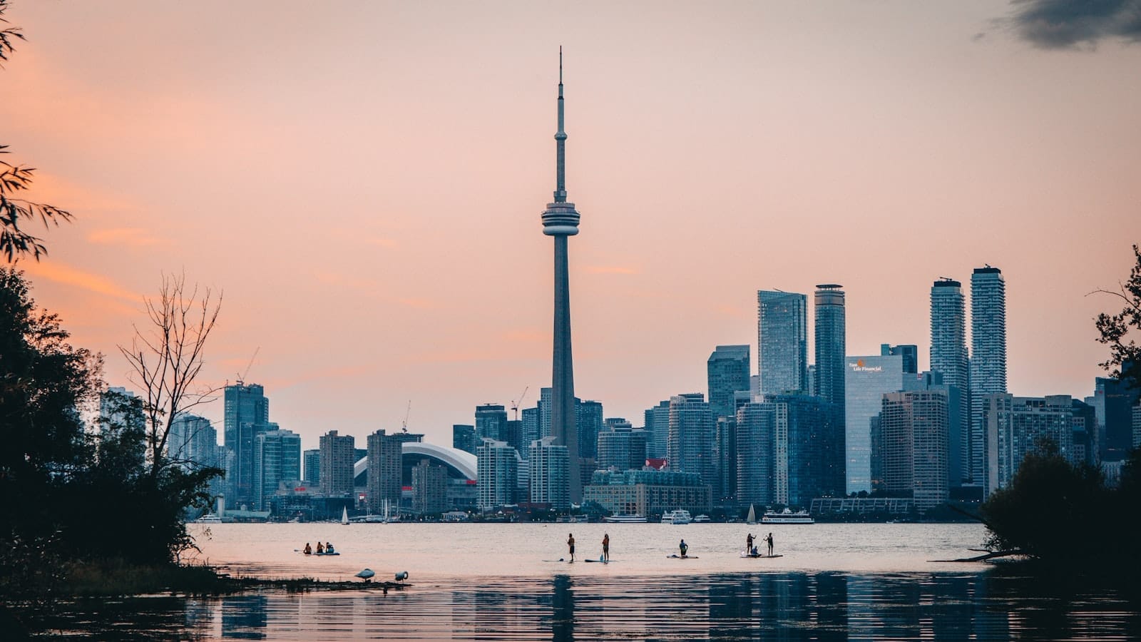
The Toronto Islands sit so close to the city that you can see the CN Tower from the shoreline, yet stepping off the ferry feels like crossing into a different world entirely. A car-free archipelago of 15 islands stretching roughly 5 kilometres across Toronto Harbour, this is where the city comes to exhale: to cycle, swim, picnic, and stare back at the skyline from a distance that makes everything look manageable.
Orientation
The Toronto Islands form a curved arc of land directly south of downtown Toronto, separated from the mainland by the narrow channel of Toronto Harbour. The archipelago stretches about 5 kilometres from Ward's Island in the east to Hanlan's Point in the west, covering roughly 332 hectares of parkland, beaches, trails, and a small year-round residential community. They sit at the front door of the city's central waterfront district, close enough that the crossings take under 15 minutes by ferry.
The islands break down into three main zones for visitors. Centre Island is the most developed and most visited: this is where you'll find the formal gardens, the amusement park, the widest beaches, and the busiest summer crowds. Ward's Island, at the eastern end, is quieter and more residential, with a tight-knit community of about 600 people living in small cottages. Hanlan's Point at the western tip is the least visited by casual day-trippers, known for its beach (including a designated clothing-optional section), its sports fields, and its adjacency to Billy Bishop Toronto City Airport.
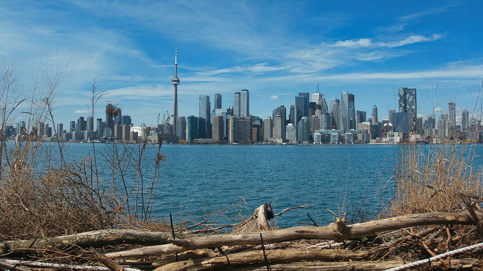
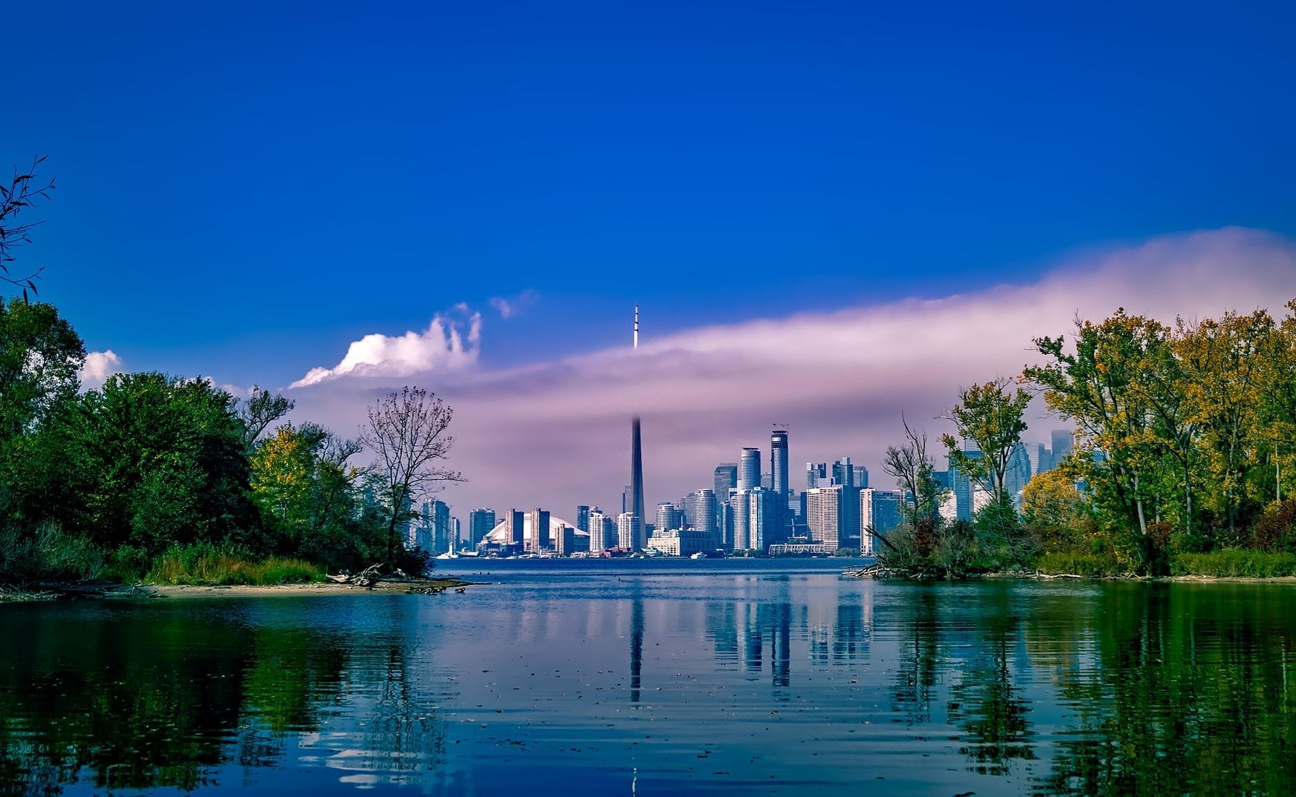
The islands curve gently around Toronto Harbour, which means the north-facing shores look directly back at the city skyline, while the south-facing shores front open Lake Ontario. The contrast between these two sides is striking: one faces towers of glass and steel, the other faces open water and, on a clear day, nothing but horizon. The interior of the islands is laced with paved and unpaved paths connecting beaches, picnic areas, and the handful of services available.
ℹ️ Good to know
Billy Bishop Toronto City Airport (YTZ) occupies the western section of Hanlan's Point but is completely separate from the island park area. There is no public access between the airport and the rest of the islands park area. Arriving at YTZ does not grant access to the park.
Character & Atmosphere
Early morning on the islands belongs to residents and committed cyclists. The ferry to Ward's Island starts running before most visitors are awake, and the paths are quiet enough at 8am that you can hear the water. The air smells of lake and cut grass. Mist sometimes sits low over the harbour on summer mornings, with the CN Tower rising above it like a needle through cloud. It is the kind of stillness that feels earned.
By midday in July or August, Centre Island transforms entirely. The ferry from Jack Layton Ferry Terminal disgorges families with strollers, school groups, couples with bikes rented at the mainland, and tourists clutching island maps. The paths near Centreville fill with the sound of children, and the snack counters develop queues. This is not a criticism so much as a description: the islands function as Toronto's most-loved urban park, and on a hot Saturday, the whole city seems to want to be here. If you're after solitude in peak summer, aim for Ward's Island or the southeast beaches rather than Centre Island at noon.
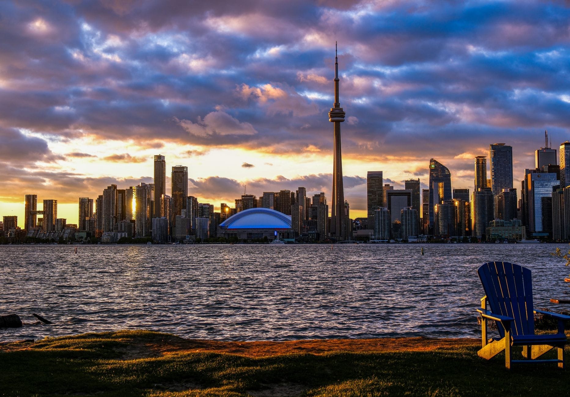
Late afternoon shifts the mood again. The light in the last two hours before sunset falls across the harbour from the west, and the skyline turns gold. Cyclists drift back toward the ferry docks slowly. People spread out on the grass near the Centre Island beach and watch the light change. It is the best time for photography, and the best time to understand why Torontonians return here so reliably, year after year.
Outside of summer, the islands become something quieter and stranger. The park closes most of its facilities in the off-season, but the Ward's Island ferry continues to run year-round for residents. Winter crossings reveal a raw, wind-scoured landscape: ice sometimes forms along the harbour edges, the paths are empty, and the skyline looks different without foliage. A handful of visitors make the winter trip for the experience itself, but honest advice is that the islands earn their reputation specifically as a warm-weather destination.
History and Cultural Significance
The land now called the Toronto Islands carries deep significance for Indigenous peoples, particularly the Mississaugas of the Credit First Nation, for whom this place has long held cultural and spiritual importance. The name Tkaronto, from which Toronto is derived, referred to a place where trees stand in the water, a description tied to this very landscape of land and lake.
The islands in their current form are relatively recent. They were a peninsula connected to the mainland until a major storm in 1858 broke the connection and created the harbour channel. Through the 19th and early 20th centuries, the islands hosted hotels, amusements, and summer residences. Much of this was cleared in the mid-20th century when the City decided to convert most of the land to parkland, removing hundreds of residents in a controversial process that left a lasting small community on Ward's and Algonquin Islands. That community, which survived years of legal uncertainty, still lives under lease arrangements with the City of Toronto.
Gibraltar Point Lighthouse, near Hanlan's Point, is one of the oldest surviving structures in Toronto, built in 1808. It no longer functions as an active lighthouse but remains standing and is worth locating on a walk through the western island. The Centreville Amusement Park on Centre Island dates to 1967 and has become a kind of institution for Toronto families across generations.
What to See & Do
The single most popular activity on the islands is cycling. The network of paved and gravel paths connects all three main island areas, and the flat terrain makes it genuinely easy for most fitness levels. Bikes can be rented near the Centre Island ferry dock. The full loop from Centre Island east to Ward's Island and back, or west toward Hanlan's Point, covers enough ground for a solid half-day. For a guide to other outdoor activities across the city, the best parks in Toronto guide offers useful context on how the islands compare to places like High Park and the Don Valley trail system.
The beaches are the other anchor of an islands visit. Centre Island Beach faces south toward open water and is the most accessible. Ward's Island Beach is smaller and quieter. Hanlan's Point Beach is the most secluded, a long sandy arc that includes a designated clothing-optional section at its northern end. All of the island beaches are free to use. For Lake Ontario's place in Toronto's geography and the broader waterfront context, the Lake Ontario guide covers the water itself in useful detail.
Centreville Amusement Park: a small-scale family amusement park on Centre Island with rides and a farm area, geared toward children. Entry to the park grounds is free; rides require tickets.
Gibraltar Point Lighthouse: the oldest lighthouse structure in Toronto, built 1808. Not open for interior visits but worth the walk.
Wards Island boardwalk and community gardens: a quiet residential streetscape unlike anything else in the city.
Algonquin Island bridge walk: cross between islands on foot to explore the residential western section.
Trout pond and nature trails: a small trout pond near Centre Island is popular with younger children.
Formal gardens near Centre Island dock: maintained flower beds and open lawn areas good for picnics.
The views back toward the city are consistently spectacular from the northern shores. The skyline, which includes the CN Tower, Rogers Centre, and the glass towers of the financial district, is best seen from the Centre Island beach or the promenade near the ferry dock. These are among the best views in Toronto available from any point in the city, and they cost nothing beyond the ferry fare.
💡 Local tip
For families visiting with young children, Centre Island is the right ferry to take. For adults looking for beaches, quiet cycling, and a slower pace, take the Ward's Island ferry and work westward from there. The two experiences are genuinely different.
Eating & Drinking
Food options on the islands are limited and almost entirely operated as seasonal concessions tied to the park. Near the Centre Island ferry dock, you will find snack counters, ice cream stands, and casual takeaway food: the kind of thing suited to a hot summer day rather than a sit-down lunch. Prices are higher than comparable mainland options, which is worth accepting as a logistical reality of operating on a car-free island.
The Rectory Café on Ward's Island is the most notable sit-down eating option on the islands. It operates as a seasonal restaurant with a proper menu, a patio overlooking the gardens, and the kind of relaxed pace that suits Ward's Island's character. It serves a mix of café food and light meals, and the patio alone is worth the eastern ferry crossing. Check opening dates before your visit, as it operates on a seasonal schedule and hours vary.
The practical reality for most visitors is to pack a picnic. The islands are explicitly built for this: there are picnic tables, open grassy areas, and barbeque pits available throughout the park. Stocking up at the mainland beforehand, whether from the St. Lawrence Market or any grocery store near the waterfront, is both cheaper and more satisfying than relying on island concessions.
Toronto's broader food scene is best explored on the mainland. The Toronto food guide covers the city's diverse restaurant landscape in depth, from the markets of Kensington to the dining strips of the east end.
Getting There & Around
The only public way to reach the Toronto Islands is by water. The City of Toronto operates the Jack Layton Ferry Terminal at the foot of Bay Street and Queen's Quay West, in the Harbourfront area. Three ferry routes serve the islands: to Centre Island (seasonal), to Ward's Island (year-round), and to Hanlan's Point (seasonal). The Centre Island ferry is the busiest, the Ward's Island ferry is the quietest, and Hanlan's Point falls somewhere in between.
The ferry terminal is about a 10-minute walk south from Union Station. From Union, walk south along Bay Street, cross Queen's Quay, and continue to the terminal. Alternatively, TTC streetcars on Queen's Quay and the 509 and 510 streetcar routes stop near Harbourfront Centre, a short walk west of the ferry terminal. The 509 Harbourfront and 510 Spadina streetcars both pass through the Harbourfront area. Full transit information is available in the getting around Toronto guide.
Ferries run frequently during summer, with service approximately every 15 to 30 minutes depending on the route and season. In peak summer, Centre Island ferries can run more frequently to handle demand. Ferry fares are paid at the terminal. Children under a certain age travel free; the exact age threshold and fare amounts can change, so check the City of Toronto's ferry page before visiting.
Private water taxis also operate between the mainland and the islands, typically departing from Harbourfront Centre or nearby docks. They are faster than the ferry and more expensive, but useful if you've missed the last ferry or want a flexible return time. Once on the islands, everything is on foot or by bicycle. There are no motor vehicles in the park area. Bikes can be rented near the Centre Island dock.
⚠️ What to skip
Ferry queues on summer weekends, especially on hot Saturdays and holiday weekends, can be very long. Arrive at the terminal at least 30 to 45 minutes before you want to depart, or consider an early morning or late afternoon crossing to avoid the worst crowds. The last ferry back to the mainland departs late in the evening in peak season, but always confirm the schedule before your visit.
Where to Stay
There are no hotels or traditional visitor accommodation on the Toronto Islands. The residential community on Ward's and Algonquin Islands consists of privately owned cottages under lease arrangements with the City, not vacation rentals or tourist lodging. If you want to sleep near the islands, the waterfront mainland is your base.
Hotels along Queen's Quay and in the Harbourfront district put you closest to the ferry terminal, with some rooms offering direct views of the harbour and the islands. The broader question of where to stay in Toronto relative to your priorities is covered in the where to stay in Toronto guide. For most visitors, staying in the downtown core or on the waterfront gives the easiest access to the islands while keeping the rest of the city within reach.
The Toronto waterfront area is worth considering as a base if the islands are a priority for your trip. You can walk to the ferry terminal in under 10 minutes from most waterfront hotels, and the Harbourfront Centre, Sugar Beach, and the western beaches are all accessible on foot.
Practical Tips and Honest Drawbacks
The Toronto Islands have a quality that is genuinely hard to replicate elsewhere in the city: a combination of proximity and separation that feels unlikely given how close you are to several million people. That said, there are real limitations worth knowing before you go.
Services on the islands are sparse. There are information hubs staffed by city personnel during peak season, first aid stations, and basic restroom facilities, but nothing like the infrastructure of the mainland. ATMs are very limited on the islands. Bring cash or cards for the concessions. Bring sunscreen, water, and more food than you think you need if you are planning a full day.
The islands are not particularly well suited to visitors with significant mobility limitations. Paved paths connect the main areas, but the distances are real, the terrain is occasionally uneven, and there is no motorized transport within the park. The ferry boarding process can also require standing in a queue for extended periods on busy days. The City of Toronto provides some accessibility accommodations at the terminal; contact the ferry service in advance if this is a concern.
For those incorporating the islands into a broader Toronto trip, the 3 days in Toronto itinerary suggests how to fit an islands day alongside visits to attractions like the CN Tower and the Harbourfront Centre, both of which are within walking distance of the ferry terminal.
💡 Local tip
The best single day on the islands: take the early Ward's Island ferry, walk west through the residential streets and along the south-facing boardwalk, continue to Hanlan's Point beach for a swim, then loop back east through the interior trails to Centre Island for late afternoon. Return on the last comfortable ferry before peak evening crowds.
TL;DR
The Toronto Islands are a car-free archipelago in Lake Ontario, less than a kilometre from downtown, best visited from late May through September.
Ideal for: families with children (Centre Island), cyclists, beach-goers, and anyone wanting skyline views from across the water.
Not ideal for: visitors looking for restaurants, nightlife, or accessible walking infrastructure. Services on the islands are limited and seasonal.
Getting there: ferry from Jack Layton Ferry Terminal at Bay Street and Queen's Quay. Approximately 10 minutes walk south from Union Station.
Peak summer weekends bring significant crowds and ferry queues. Early morning or weekday visits offer a completely different, quieter experience.
Three days is enough time to cover the best of Toronto's downtown core, historic districts, waterfront, and cultural institutions — if you plan smartly. This itinerary is built around the TTC subway and streetcar network, so you never need a rental car. Expect a mix of landmark sights, neighbourhood wandering, and genuine local texture.
Toronto punches well above its weight for museum culture. Whether you're drawn to ancient civilisations, contemporary art, or the history of hockey, this guide covers the best museums in Toronto across every interest and budget.
Toronto has over 1,500 parks and more than 8,000 hectares of green space, from sweeping urban forests and lakefront trails to formal gardens and island beaches. This guide covers the best of them, organised by type and neighbourhood, so you can find exactly the kind of outdoor escape you're looking for.
Toronto has four genuinely distinct seasons, and the best time to visit depends entirely on what you want from the trip. This guide breaks down weather, crowds, pricing, and events month by month so you can make an informed decision.
Toronto's skyline is one of the most dramatic in North America, dominated by the CN Tower and framed by Lake Ontario. This guide covers the best vantage points in the city, from high-rise observation decks and waterfront parks to island ferry crossings and hilltop lookouts.
Toronto sits at the centre of one of Canada's richest regions for day-tripping. Within two hours in any direction you'll find roaring waterfalls, wine country, historic theatre towns, wilderness beaches, and mountain resorts. This guide covers the top day trips from Toronto, with practical details on how to get there and what to do once you arrive.
Toronto is a surprisingly generous city for budget travellers. From free museum evenings and sprawling parks to street art laneways and historic neighbourhoods, here are the best free things to do in Toronto across every season.
Toronto's transit network spans the TTC subway, streetcars, GO Transit regional rail, the UP Express airport link, ferries, and bike share. This guide breaks down every option with fares, routes, timings, and practical advice on what actually works for visitors.
Toronto is one of the safest major cities in North America, but that doesn't mean risk-free. This guide breaks down real crime patterns, which areas to be aware of, seasonal hazards, and the practical precautions that actually make a difference for visitors.
Toronto sits on the northwestern shore of Lake Ontario, the easternmost and smallest of the Great Lakes by surface area. From the Toronto Islands and the Martin Goodman Trail to the towering Scarborough Bluffs, this guide covers every major way to experience the lake — with seasonal advice, transit details, and honest assessments of what's worth your time.
Toronto is Canada's largest city and one of North America's most genuinely diverse destinations. This guide covers the best things to do in Toronto across every budget, season, and interest — with honest assessments, current prices, and practical logistics.
Five days in Toronto is enough time to cover the iconic landmarks, dig into the city's diverse neighbourhoods, and still squeeze in a day trip to Niagara Falls. This itinerary is structured for efficiency without sacrificing depth, whether you're arriving at Pearson Airport or Billy Bishop.
Everything you need to navigate Toronto Pearson International Airport (YYZ), from terminal layouts and airside connections to the fastest and cheapest ways into downtown Toronto. Covers the UP Express, taxis, ride-hailing, public transit, and key practical details for first-timers and connecting passengers.
Toronto's skyline tells a 200-year story in brick, glass, and concrete. This guide covers the city's most architecturally significant buildings across every era, from Victorian flatirons and Beaux-Arts civic halls to Gehry-designed galleries and record-breaking towers, with practical visiting tips for each.
Toronto Caribbean Carnival, still widely known as Caribana, draws over a million visitors to the city each summer for more than a week of soca music, steelpan competitions, costumed masquerade, and street food. This guide covers everything: dates, the Grand Parade route, ticket prices, what to skip, and how to plan your visit like someone who has been before.
Toronto's sakura season is spectacular but brutally short. This guide covers the exact bloom window, the best viewing locations beyond High Park, how to get there without a car, and what the City's official trackers actually tell you in real time.
Toronto's food scene is one of North America's most diverse, shaped by over 200 ethnic communities and anchored by legendary markets, neighbourhood food districts, and a Michelin Guide earned in 2022. This guide breaks down what to eat, where to eat it, and how to navigate the city's culinary landscape like a local.
Toronto's food market scene ranges from a historic 200-year-old market hall to shipping-container villages and neighbourhood farmers' markets. This guide covers the best places to browse, graze, and stock up across the city.
Toronto delivers a surprising range of romantic experiences, from skyline dining and waterfront ferry rides to candlelit heritage districts and world-class performing arts. This guide breaks down the best date ideas by season, budget, and vibe, with honest assessments of what's worth the effort.
Summer turns Toronto into one of North America's most active outdoor cities. From June jazz on Bloor Street to Caribbean Carnival floats and lakefront beaches with lifeguards on duty until Labour Day, this guide covers every major event, the best swimming spots, and the practical logistics to make the most of the season.
Toronto winters are cold, but the city leans into the season rather than shutting down. From free outdoor skating rinks under the Gardiner Expressway to the glittering Distillery District Christmas Market, this guide covers every practical detail you need to enjoy Toronto from late November through March.
The Toronto International Film Festival is one of the world's most accessible and influential film events, open to the public every September. This guide covers dates, ticket prices, venues, logistics, and how to get the most out of your visit.
The Toronto Islands are a chain of 15 car-free islands just a short ferry ride from downtown, offering beaches, cycling trails, skyline views, and a rare slice of calm in the middle of a major city. This guide covers ferry logistics, the best spots on each island, seasonal realities, and the common mistakes first-time visitors make.
Toronto's upscale travel scene goes well beyond five-star hotels. This guide covers the best luxury hotels in downtown Toronto and Yorkville, premium dining, exclusive experiences, and practical logistics for high-end visitors to Canada's largest city.
Toronto is one of the most diverse cities in the world, with roughly half its population born outside Canada. This guide covers the key ethnic districts, what makes each distinct, how to get there, and what to prioritize on a visit.
Niagara Falls sits about 136 km from downtown Toronto, making it the most popular day trip from the city. This guide covers every transport option, realistic costs, seasonal timing advice, and practical tips on what is worth your time once you arrive.
Toronto nightlife runs deeper than most visitors expect. From the dense bar corridor along King West to indie live music rooms on Queen West and all-night clubs in the Entertainment District, this guide breaks down where to go, what to spend, and how to plan your night like a local.
Nuit Blanche Toronto is a free, city-run all-night contemporary art festival that transforms public spaces across Toronto from dusk to dawn each October. This guide covers the event's history, logistics, what to expect on the night, and how to make the most of 12 hours of outdoor art.
Toronto is Canada's largest city and one of North America's most expensive destinations — but with the right approach, you can experience it without draining your wallet. This guide covers free attractions, affordable transit, budget eats, and the smartest times to visit to keep costs low.
Toronto's PATH is the world's largest underground pedestrian network, stretching more than 30 km through the heart of downtown. This guide covers how to navigate it without getting lost, which routes to use, when it's open, and what to realistically expect from the experience.
Toronto's ravine system is one of the largest urban greenspace networks in North America, threading through neighbourhoods most visitors never see. This guide covers the best trails, how to reach them by transit, what conditions to expect by season, and how to string routes together for a full day outdoors.
Toronto's shopping scene spans luxury boutiques in Yorkville, 230-plus retailers at the Eaton Centre, historic indoor markets, and independent street strips that reward slow browsing. This guide breaks down every major option by category, with transit directions, honest assessments, and seasonal tips.
Toronto is one of North America's most practical cities for solo travel, with an extensive transit network, walkable districts, and a concentration of world-class attractions in the downtown core. This guide covers everything from airport arrivals and neighbourhood logistics to safety realities and the best solo-friendly experiences across Canada's largest city.
Toronto rewards walkers. From the Victorian laneways of the Distillery District to the lakefront trail and Kensington Market's chaotic grid, the city's best stories are told on foot. This guide covers the top guided walking tours, free tip-based options, City-published self-guided routes, and the neighbourhoods worth exploring on your own schedule.
Toronto's waterfront runs approximately 37 kilometres along Lake Ontario, from Etobicoke in the west to the Rouge River in the east. This guide covers the best things to do, how to get around, seasonal conditions, and which parts of the lakeshore are actually worth your time.
From shark tunnels at Ripley's Aquarium to free ferry rides and dinosaur bones at the ROM, Toronto delivers serious options for families with children of all ages. This guide covers the top attractions, practical logistics, honest pricing, and seasonal advice to help you plan a trip that actually works.
Toronto has dozens of distinct neighbourhoods, and choosing the right one to stay in makes a real difference to your trip. This guide breaks down the best areas by location, price range, transit access, and atmosphere — so you can book with confidence.