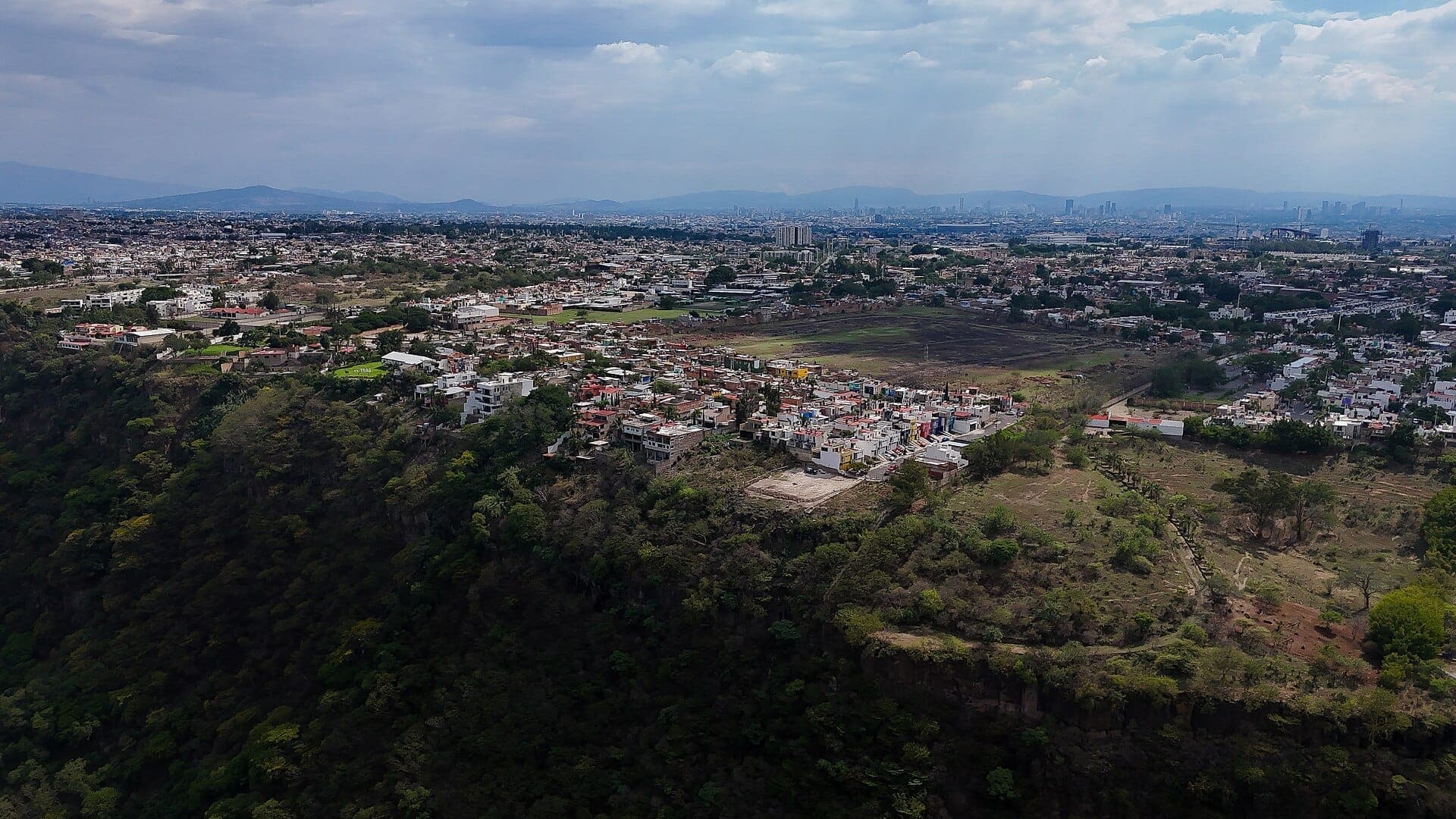
Huentitán is a residential district on Guadalajara's northern edge where the city abruptly ends at the rim of a 600-meter canyon carved by the Río Grande de Santiago. The Barranca de Huentitán, also known as the Barranca de Oblatos, is one of the most dramatic natural features within any major Mexican city, offering steep trail hikes, canyon-floor access, and sweeping views that most visitors to Guadalajara never see.
At the northern limit of Guadalajara, the city grid stops and the earth drops away into the Barranca de Huentitán, a canyon up to 600 meters deep carved by the Río Grande de Santiago. This is not a neighborhood for sightseeing in the conventional sense: no boutique hotels, no café rows, no art galleries. What it offers instead is raw urban geography, serious hiking inside a protected natural area, and a window into a part of Guadalajara that functions entirely on its own terms.
Orientation
Huentitán sits at the far northern end of Guadalajara municipality, roughly 10 to 13 kilometers north of the Centro Histórico. The district divides broadly into Huentitán El Bajo, closer to the canyon floor, and Huentitán El Alto, which occupies the plateau rim where most residents live and where the main trail access begins. The canyon itself forms the natural northern boundary of the city, beyond which the terrain falls into the gorge before the municipality of Zapotlanejo begins on the far side.
The Barranca de Huentitán is part of a wider canyon system that touches several municipalities: Guadalajara, Tonalá, Zapotlanejo, Ixtlahuacán del Río, and Zapopan all share borders along this geological feature. The protected urban segment, where most visitor access is concentrated, sits within Guadalajara municipality. Calzada Independencia Norte is the main artery that connects the district southward to the Centro Histórico, running parallel to the barranca's eastern edge for several kilometers before reaching the city center.
For orientation within the wider city, Huentitán is easiest to understand as the northern terminus of the Calzada Independencia corridor, the same avenue that runs past Parque Agua Azul and the Mercado San Juan de Dios in the south before climbing all the way to the canyon rim. Everything north of the Parque Mirador Independencia belongs to this district's gravitational field.
Character & Atmosphere
Huentitán El Alto is a dense, working-class residential colonia. The streets are lined with small tiendas, taco stands, mechanics, and the kind of neighborhood infrastructure that supports families who have lived here for generations rather than newcomers or tourists. There are no craft cocktail bars on the corner and no co-working spaces. The pace is practical and the noise is ordinary urban Mexico: delivery trucks, cumbia from a window, children out after school.
The closer you get to the canyon rim, the more the character shifts. Near the mirador and the trail entrance, the urban fabric gives way to scrubby vegetation, chain-link fencing, and then suddenly nothing, just a view that falls hundreds of meters to the river below. On weekend mornings, local families and serious hikers congregate near the access point. Vendors sell water, snacks, and electrolyte drinks to people heading down. By midday on a warm day, the canyon trail becomes quiet: the heat at the bottom is genuinely punishing and most people are already back up.
After dark, the canyon area offers nothing and the residential streets are typical of any working neighborhood at night: quiet but not particularly welcoming to strangers on foot without purpose. This is not an area with a nightlife economy. Visitors who come for the hike typically arrive early in the morning and leave by early afternoon.
ℹ️ Good to know
The Barranca de Huentitán is sometimes listed under two names: Barranca de Huentitán and Barranca de Oblatos. Both refer to the same canyon system. The name used tends to depend on which access point or municipality is being referenced, but for visitors approaching from Guadalajara city, Huentitán El Alto is the practical entry point.
What to See & Do
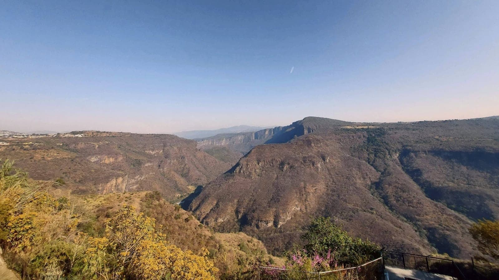
The primary draw is the canyon itself. The Barranca de Huentitán trail descends from the rim in Huentitán El Alto to the canyon floor near the Río Grande de Santiago. The descent involves a significant elevation change, steep switchbacks, and exposed sections with little shade. The round trip typically takes between three and five hours depending on pace, fitness, and how long you spend at the bottom. The trail is not a gentle nature walk: it demands proper footwear, plenty of water, and an honest assessment of your fitness level.
At the canyon floor, the relocated Puente de Arcediano spans the river and marks the lowest accessible point for most visitors. The scale of the gorge from the bottom is different from anything you see at the rim: the walls rise steeply on both sides, the air is warmer and more humid, and the sound of the city disappears entirely. Bring more water than you think you need, because the climb back out in afternoon heat is substantially harder than the descent.
Near the canyon rim, the Parque Mirador Independencia provides a paved, accessible viewpoint with benches and barriers where you can look out over the barranca without committing to the full hike. This is where families gather on Sunday mornings, where teenagers come to take photographs, and where the sheer scale of the geography becomes clear. It is worth the trip from the center even if you do not plan to descend.
Hike the Barranca de Huentitán trail to the canyon floor and the Puente de Arcediano
Watch the sunrise from the Parque Mirador Independencia rim viewpoint
Look for bird species in the canyon's protected vegetation zones, including raptors that ride thermals above the gorge
Walk the residential streets of Huentitán El Alto for an unfiltered view of working Guadalajara life
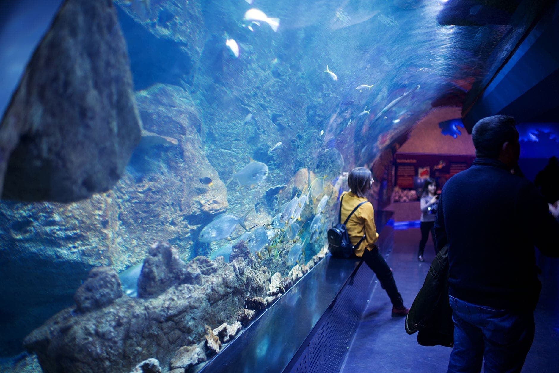
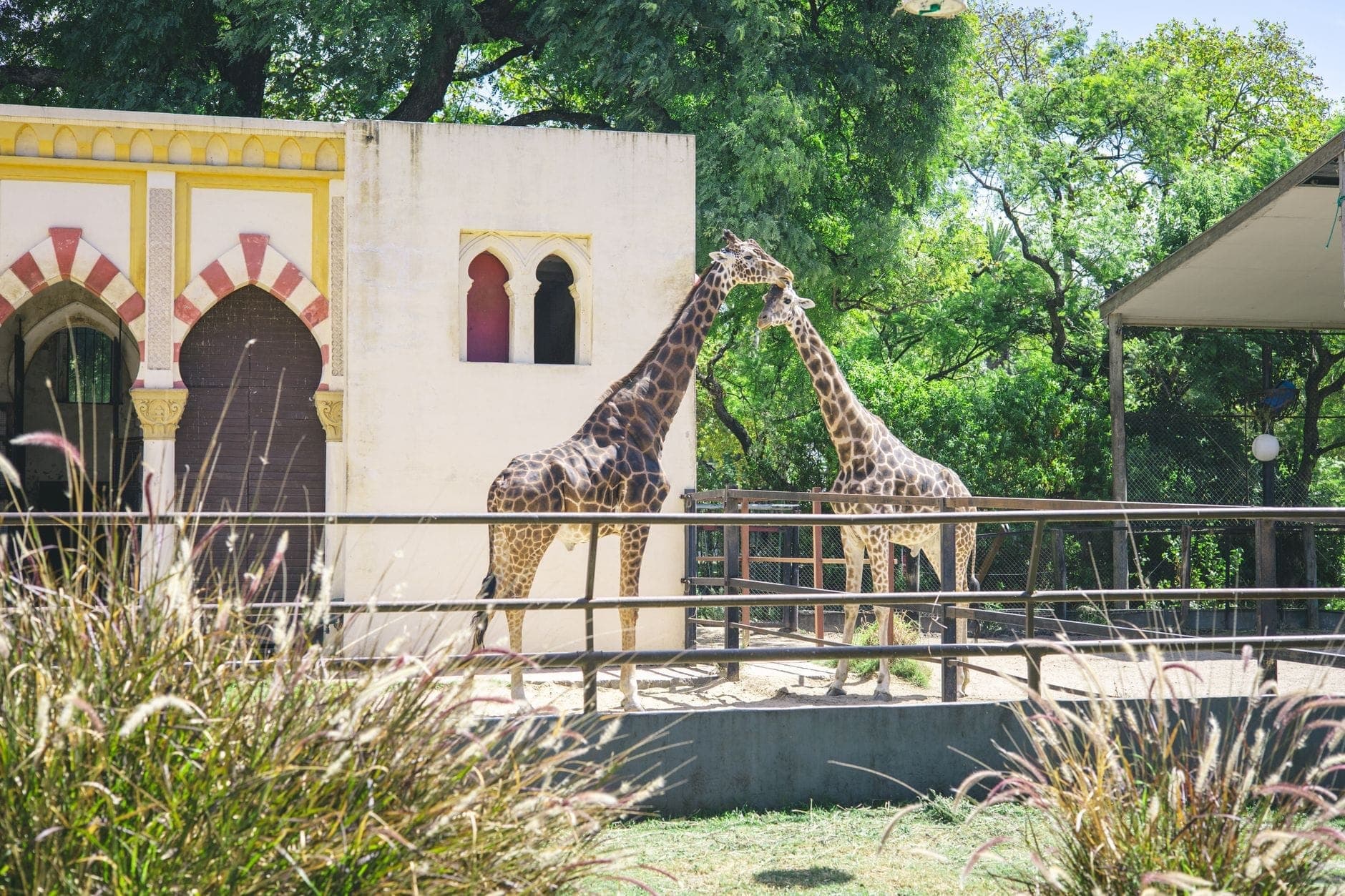
Visit the zoo: Zoológico Guadalajara is located at the canyon edge, accessible from this district
One attraction that often surprises visitors is the Zoológico Guadalajara, which sits at the canyon rim and is considered one of the better zoological parks in western Mexico. It is a legitimate draw for families and is close enough to the mirador that a morning can include both. The zoo's location at the edge of the barranca means some enclosures have canyon backdrops that are genuinely unusual.
⚠️ What to skip
The canyon hike should not be attempted in the midday heat, especially between May and September when temperatures at the canyon floor can exceed 35°C. Start no later than 7am if you plan the full descent and return. Carry at least two liters of water per person. There is no infrastructure at the bottom: no vendors, no medical support, no shade structures.
Eating & Drinking
The food scene in Huentitán is entirely local and entirely practical. There are no destination restaurants here and no tourist-facing dining strips. What you find are neighborhood taquerías, small fondas serving set comida corrida lunches, aguas frescas vendors near the mirador, and corner stores selling provisions. The cooking is straightforward Jaliscan home food: birria, tacos de canasta, pozole on weekends, tamales in the morning.
Near the Parque Mirador Independencia and the zoo entrance, informal vendors and small food stalls set up on weekend mornings. This is where you can get a torta ahogada or a cup of atole before heading down into the canyon. Prices are low by any standard: a full breakfast from a street vendor will typically cost under 60 pesos. There are no cafés in the specialty coffee sense of the word anywhere in this district.
Anyone wanting a more varied meal before or after the hike should plan to eat in the Centro Histórico or along Calzada Independencia on the way back south. The neighborhood's eating options are worth experiencing for their authenticity and price, but they will not satisfy someone looking for variety or dietary alternatives.
💡 Local tip
If you are planning the canyon hike, buy your water and any snacks at the small stores in Huentitán El Alto before you reach the trailhead. Options thin out quickly once you leave the residential streets, and nothing is available at the canyon floor.
Getting There & Around
The most direct public transit route from the city center to Huentitán El Alto is via the Mi Macro Calzada BRT line (formerly Macrobús), which runs along Calzada Independencia from the south of the city northward. The route terminates at northern stations near the canyon area, making it the most convenient transit option for visitors approaching from downtown or the Centro Histórico. Journey time from the center is approximately 25 to 40 minutes depending on traffic and stops.
For detailed guidance on Guadalajara's transit network, including how to use the BRT and city bus system, see the getting around Guadalajara guide. The Mi Macro Calzada is integrated with the broader Mi Transporte bus network, and a single fare covers transfers within the system within a set time window.
Ride-hailing apps including Uber and DiDi operate throughout Guadalajara and will take you directly to the Parque Mirador Independencia or the zoo entrance without difficulty. From the Centro Histórico, the fare is modest and the journey takes around 20 to 30 minutes depending on time of day. Driving independently is straightforward: Calzada Independencia Norte is the main road north. Parking near the mirador is limited on weekend mornings when the area is busiest.
Line 1 of the SITEUR metro system runs along a north-south corridor in Guadalajara but does not extend as far north as Huentitán. The closest metro access points are several kilometers south of the canyon area, meaning the BRT or ride-hailing is the more practical choice for reaching this neighborhood. Walking from the Centro Histórico is not a realistic option: the distance is roughly 8 to 10 kilometers on a route that passes through unremarkable urban streets.
Where to Stay
There are essentially no hotels in Huentitán El Alto aimed at tourists, and staying in this neighborhood is not something most visitors would choose. The accommodation infrastructure does not exist here: no hostels, no boutique properties, no serviced apartments marketed to visitors. Families visiting the zoo might find a basic guesthouse in the broader northern zone, but there is no reason to look.
For visitors whose primary goal is the canyon hike, the practical strategy is to stay in the Centro Histórico or along Avenida Vallarta and make a morning trip north. Both areas offer a full range of accommodation options and are well connected to the Calzada Independencia corridor. See the where to stay in Guadalajara guide for a comparison of the city's main accommodation neighborhoods.
Practical Notes for Visitors
Huentitán fits into a broader picture of Guadalajara's outdoor and nature options. If you are building a multi-day itinerary, the canyon works well as a half-day excursion combined with an afternoon in the Centro Histórico. Start at the canyon rim at dawn, descend and return by 11am, then take the BRT south to the historic center for the afternoon.
The best months to attempt the hike align with Guadalajara's dry season, roughly November through April, when temperatures are more moderate and the trail surface is drier. During the rainy season from June through September, the descent can become slippery and the river level at the bottom rises. For general seasonal guidance on visiting Guadalajara, the best time to visit Guadalajara covers climate patterns across the year.
For visitors interested in Guadalajara's wider outdoor geography, the canyon connects thematically with other natural areas around the city, including Bosque La Primavera on the western edge of the metro area. Both represent a side of Guadalajara that exists in parallel with the colonial architecture and food markets, and both reward early starts.
Safety in the canyon itself is primarily a matter of physical preparation rather than crime. The trail is used regularly by local hikers and there are no specific security advisories for the access area. As with any urban fringe area, standard urban awareness applies in the residential streets: avoid displaying expensive equipment and do not linger after dark. For current safety context across Guadalajara more broadly, the is Guadalajara safe guide covers the relevant considerations.
TL;DR
Huentitán is for hikers and outdoor visitors: the Barranca de Huentitán offers one of the most dramatic natural landscapes accessible from any major Mexican city, with a trail that descends about 500–520 meters to the Río Grande de Santiago.
The Parque Mirador Independencia provides canyon views without the physical commitment of the full hike, making it accessible for families and casual visitors.
The Zoológico Guadalajara at the canyon rim is a legitimate draw for families and is easy to combine with a morning at the mirador.
There are no tourist amenities, hotels, or destination restaurants here: this is a working neighborhood that happens to sit above a spectacular canyon.
Best approached as a morning excursion from the Centro Histórico or Vallarta corridor, via the Mi Macro Calzada BRT or ride-hailing. Not recommended for afternoon visits in summer due to canyon heat.
Top Attractions in Huentitán & Barranca de Oblatos
Three days is enough to cover Guadalajara's colonial core, its craft-focused suburbs, and a day trip to the town that gave tequila its name. This itinerary is structured around walking distance, public transport, and realistic timing — not nierealnych oczekiwań.
Guadalajara is a stronger museum city than many visitors expect. From the UNESCO-listed Hospicio Cabañas to free contemporary art at MUSA, here are the best museums in Guadalajara, organized by theme so you can plan your time well.
Guadalajara's climate divides cleanly into a dry season and a rainy season, but the best time to visit depends on what you're after. This guide breaks down weather, festivals, crowds, and pricing by season so you can plan with confidence.
Guadalajara sits at the center of one of Mexico's richest regions for day tripping. Within about two hours in any direction you'll find UNESCO World Heritage sites, mountain Pueblos Mágicos, Mexico's largest freshwater lake, and ancient circular pyramids unlike anything else in the country.
Guadalajara rewards budget travelers more generously than almost any city in Mexico. Its historic plazas, colonial churches, world-class murals, urban forests, and street markets are largely free to enter, making it possible to spend days here without opening your wallet.
Guadalajara has one of the most practical urban transport networks in Mexico. This guide breaks down every option — from the MiTren metro to MiBici bike-share — with real prices, route logic, and clear guidance on what to skip.
Miguel Hidalgo y Costilla International Airport (GDL) is Mexico's third-busiest airport, handling over 17 million passengers a year. This guide covers every transfer option from the airport to Guadalajara city center, terminal layouts, facilities, and practical arrival tips so you know exactly what to expect before you land.
Guadalajara's architectural story spans five centuries, from the towering twin spires of its Metropolitan Cathedral to the clean geometric lines of Luis Barragán's early modernist houses. This guide covers the landmark buildings worth your time, how to visit them, and the historical context that makes each one matter.
Day of the Dead in Guadalajara is a multi-week affair that blends pre-Hispanic tradition, Catholic observance, and the city's own Fiestas de Octubre into something far bigger than a single night. This guide covers the best altar displays, cultural events, practical logistics, and common misconceptions so you can experience it properly.
Guadalajara, Jalisco is quietly becoming one of Latin America's most practical bases for remote workers. This guide covers monthly costs, coworking spaces, the best neighborhoods, visa options, internet reliability, and everything else you need to decide if Mexico's second-largest city is right for your nomad setup.
Guadalajara, Jalisco, Mexico hosts some of Latin America's most significant cultural events — a world-class film festival, the largest Spanish-language book fair, October-long celebrations, and a mariachi gathering with deep roots in Jalisco identity. This guide breaks down the full annual calendar with practical detail on timing, crowds, and what actually deserves your attention.
Guadalajara, Jalisco is one of Mexico's most important food cities, home to torta ahogada, birria, carne en su jugo, and jericalla. This guide covers every essential dish, where to find the best versions, what to pay, and how to eat like a local from breakfast through late-night cantina.
Guadalajara, Jalisco's capital, rewards couples with colonial plazas, candlelit Tlaquepaque galleries, agave-field train rides, and one of Mexico's most walkable lake shores. This guide covers the most genuinely romantic experiences in the city, with honest timing advice, neighborhood breakdowns, and booking details.
October is one of Guadalajara's most eventful months, with the citywide Fiestas de Octubre, the lead-up to Día de los Muertos, and weather that finally starts to ease off the rainy season. This guide covers what to expect, what to pack, how to book smart, and which events are worth your time.
Guadalajara, Jalisco, is the cultural capital of mariachi music. This guide covers the best places to hear live performances, how to hire a band, what the International Mariachi Festival involves, and what to expect as a first-time visitor — including honest notes on pricing, crowds, and common misconceptions.
Guadalajara has one of Mexico's most dynamic nightlife scenes, built around world-class tequila bars, craft cocktail lounges, and clubs that run until dawn. This guide covers the best neighborhoods, top venues by category, what things actually cost, and how to navigate the scene like a local.
Guadalajara, Jalisco, Mexico is one of the most affordable major cities in North America for travelers. This guide breaks down real costs for transport, accommodation, food, and attractions, plus timing tips to stretch your pesos further.
Guadalajara and Mexico City are both world-class destinations, but they offer very different experiences. This guide breaks down the key differences in size, cost, climate, culture, and logistics so you can make an informed choice — or plan both.
Guadalajara's Centro Histórico is one of Mexico's most walkable downtown cores, with a chain of linked plazas connecting colonial churches, world-class murals, and a UNESCO World Heritage site within roughly 5 kilometres. This guide gives you a practical route, landmark-by-landmark breakdown, opening hours, and the practical tips you need to do it right.
Guadalajara, Jalisco, Mexico packs a remarkable range of kid-friendly attractions into a compact, navigable city. This guide covers the top family activities, practical logistics, seasonal advice, and honest rankings to help you plan a trip your kids will actually enjoy.
Guadalajara is one of Mexico's largest metropolitan areas and one of the country's most culturally significant cities. But is it worth your trip? This guide cuts through the hype with a clear-eyed look at what the city actually offers, who it suits best, and what to watch out for.
Guadalajara, Mexico is moderately safe for tourists who travel smart. This guide breaks down the real risks by neighborhood, time of day, and transport type, so you can plan your trip with accurate expectations rather than fear or false confidence.
Mexico's largest freshwater lake sits just one hour from Guadalajara, making it one of the most rewarding day trips in Jalisco. This guide covers how to get there independently or on a guided tour, what to do in Chapala and the Pueblo Mágico of Ajijic, honest seasonal advice, and what the tourism brochures tend to leave out.
Guadalajara holds the greatest concentration of José Clemente Orozco murals in the world, anchored by the UNESCO-listed Hospicio Cabañas and the Palacio de Gobierno. This guide covers every major site, what to look for in each fresco cycle, practical visiting logistics, and clear guidance on what to skip.
Guadalajara, Jalisco, Mexico offers one of Mexico's most diverse shopping landscapes — from one of the country's largest indoor markets to artisan towns, high-end malls, and a major shoe district. This guide breaks down where to go, what to buy, and how to avoid overpaying.
The town of Tequila is 60–70 km northwest of Guadalajara and one of the most rewarding day trips in all of Mexico. This guide covers every transport option, the best distillery tours, what the Jose Cuervo Express train actually delivers, and how to avoid the most common tourist mistakes.
Guadalajara, the capital of Jalisco, is one of Mexico's most rewarding cities for travelers who look beyond the obvious. This guide covers the best things to do in Guadalajara, from the UNESCO-listed Hospicio Cabañas to craft markets in Tlaquepaque, with practical details on timing, pricing, and what to skip.
Choosing where to stay in Guadalajara, Jalisco shapes your entire trip. This guide breaks down the city's top neighbourhoods by travel style, with straightforward assessments of what each area delivers, what it lacks, and who it suits best.