Barranca de Huentitán: Guadalajara's Deepest Natural Escape
Barranca de Huentitán (officially Barranca de Oblatos) is a protected 1,136-hectare canyon on Guadalajara's northeastern edge, carved by the Río Grande de Santiago to a depth of roughly 500–600 meters at its deepest points. Access is free, the hiking is demanding, and the scale of the landscape is unlike anything else within the city limits.
Quick Facts
- Location
- Huentitán El Alto, northeast Guadalajara. Trailhead near Av. Belisario Domínguez 4446, Col. Dr. Atl
- Getting There
- Metro Line 1 to Periférico Norte, then taxi or Uber to trailhead (~10 min). Or Macrobús Line 1 to Mirador, then taxi.
- Time Needed
- 4–5 hours for the full round-trip hike (approx. 9–10 km)
- Cost
- Free (canyon trail access). Guided tours charge their own fees.
- Best for
- Hikers, nature lovers, photography, early-morning solitude
What Barranca de Huentitán Actually Is
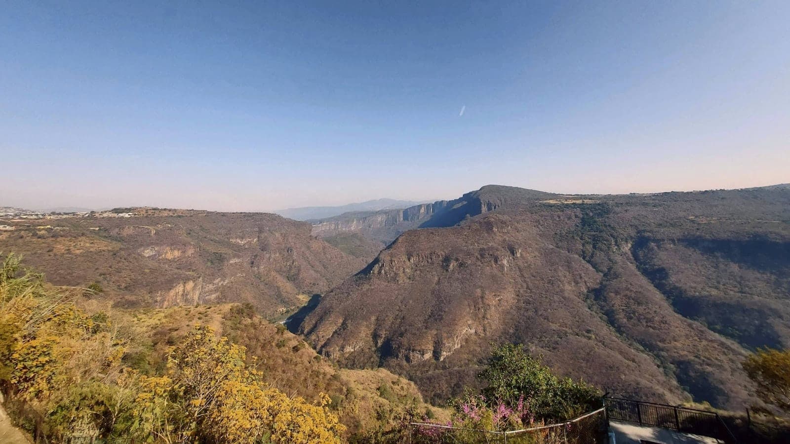
Most visitors come to Guadalajara and never realize the city ends abruptly at one of its edges in a sheer drop of roughly 500–600 meters. The Barranca de Huentitán, also known as Barranca de Oblatos, is a protected natural area of approximately 1,136 hectares carved over millennia by the Río Grande de Santiago. The river still runs at the canyon floor, invisible from the rim until you have descended far enough into the vegetation to hear it.
The canyon sits to the north of the municipality of Guadalajara, where the urban grid simply stops and the earth falls away. The rim elevation hovers around 1,520 meters above sea level; the river at the bottom sits near 1,000 meters. That 520-meter difference in a single descent is what defines the physical experience. You are not walking in a gentle park. You are descending into a different ecological zone.
The area was declared a Protected Natural Area in 1997, recognized as a biogeographic corridor. This status matters: the canyon shelters species of birds, reptiles, and plants that do not exist in the urban fabric above. For context, this canyon is a natural counterpart to the cultural sites that define the city's historic core. If you are building a fuller picture of Guadalajara beyond its plazas and colonial architecture, see the Guadalajara architecture guide for how the built and natural environments of this city relate to each other.
The Descent: What the Trail Feels Like
The main trailhead used by most visitors is near the Capilla de la Barranca de Huentitán on Avenida Belisario Domínguez in the Colonia Dr. Atl neighborhood. From the street, the change is immediate: one moment you are on a residential road with corner tiendas and parked cars, the next you are looking at a wall of tropical-dry forest dropping below your feet.
The trail down is loose in places, rocky in others, and consistently steep. Trekking poles are genuinely useful, not just for comfort. The path descends through several distinct vegetation bands: the scrubby, sun-bleached upper rim gives way to increasingly dense tree cover as you lose altitude, and the air temperature drops noticeably. By the time you reach the river zone, the light is different, the humidity is higher, and the sounds of the city have completely disappeared. What replaces them is the river, birds, and wind in the canyon walls.
⚠️ What to skip
The return ascent is harder than the descent and takes longer than most visitors expect. Budget more time going up than coming down. In warm months, carry at least 2 liters of water per person. There are no vendors, no water sources, and no shade guarantees on the upper sections.
The round trip covers approximately 9 to 10 kilometers and typically takes 4 to 5 hours for a fit adult at a moderate pace. The trail is described consistently by those who have done it as demanding rather than technical: you do not need climbing equipment, but you do need decent footwear with grip, physical stamina, and the willingness to take the climb back out seriously.
Best Time of Day and Best Season
Start as early as possible, ideally at first light. The canyon rim faces northeast, which means early morning light hits the opposite canyon walls in ways that are difficult to photograph later in the day. More practically, the upper sections of the trail are fully exposed, and once the sun is high, the heat on the descent becomes a real factor, particularly from April through June when temperatures at the rim can reach 30 to 32 degrees Celsius.
Guadalajara's rainy season runs from June through September, with July and August typically the wettest months. Rain transforms the canyon: the vegetation becomes intensely green, waterfalls appear on the canyon walls, and the river runs higher and faster. It is also when the trail turns slippery and flash flooding risk at the bottom increases. If you visit during rainy season, check conditions locally before descending, and avoid going down if there has been heavy rain in the previous 24 hours.
For the most comfortable hiking conditions, November through February offers drier trails, cooler temperatures, and better visibility across the canyon. This aligns with the broader best time to visit Guadalajara in terms of climate. The canyon is at its lushest after rainy season ends in October, making October and November a sweet spot for both conditions and scenery.
💡 Local tip
Weekday mornings between 7 and 9 a.m. offer the quietest experience. Weekends attract local hikers and small tour groups; the trail becomes more social and occasionally crowded near the trailhead.
Photography and What You Actually See
The canyon's scale is hard to communicate in a single frame. From the rim, you are looking at a landscape that has no parallel elsewhere in the metropolitan area. The far walls are layered in color: pale volcanic rock near the top, darkening to green-grey where moisture collects, and disappearing into tree canopy below. On clear mornings, the river appears as a thin silver line at the bottom.
Bird activity is highest in early morning and late afternoon. The canyon is known among local naturalists for its raptor sightings, including species that use the thermal columns rising from the heated canyon walls. Bring binoculars if birds are a priority. The mid-canyon sections offer some of the most dramatic framing for landscape photography, particularly where the trail crosses open scree slopes with unobstructed views in both directions along the canyon.
For views of the canyon without the full hike, the nearby Parque Mirador Independencia offers accessible rim viewpoints that require no trail descents. It is a legitimate alternative for visitors who want the visual experience without the physical commitment.
Getting There: Transit and Practical Logistics
The canyon trailhead is not walking distance from central Guadalajara. The most practical approach by public transit is Metro Line 1 (SITEUR) to the Periférico Norte station, followed by a short taxi or Uber ride to the Huentitán El Alto neighborhood and the Belisario Domínguez trailhead area. Alternatively, the Macrobús Line 1 (Mi Macro Calzada) stops at the Mirador station, from which a taxi completes the journey. Either way, budget time for the final transfer: ride-hailing apps work well in this area, but confirm the pickup address precisely before requesting.
Driving is straightforward if you have a vehicle. Parking exists near the Capilla de la Barranca de Huentitán on Avenida Belisario Domínguez, though spaces fill quickly on weekend mornings. If you arrive after 8 a.m. on a Saturday, expect to park further away and walk.
ℹ️ Good to know
There is no dedicated official website for Barranca de Huentitán. Information on guided tours and current trail conditions is best found through local tour operators or recent traveler reports. The canyon itself has no ticket booth, ranger station, or formal visitor infrastructure at the main trailhead.
What to Bring and How to Prepare
- Hiking footwear with ankle support and grip: the trail surface varies from packed dirt to loose rock
- Minimum 2 liters of water per person; more in warm or dry season
- Sun protection for the exposed upper sections: hat, sunscreen, sunglasses
- Snacks for energy on the return ascent
- A light layer for the canyon floor, which can be noticeably cooler and more humid than the rim
- Charged phone with an offline map downloaded, as cell coverage inside the canyon is unreliable
- Cash is unnecessary for trail access, but useful for transport and post-hike food near the neighborhood
Accessibility and Who Should Skip This
The Barranca de Huentitán is not accessible to visitors with limited mobility. The trail involves a steep, uneven descent and an equally demanding return ascent, with no paved paths, handrails, or alternative routes to the canyon floor. There are no benches, shelters, or rest facilities along the trail itself.
Visitors who want nature without physical exertion should consider Bosque Los Colomos instead, which offers flat walking paths in a well-maintained urban forest setting. The Parque Mirador Independencia rim viewpoints are also accessible and free, providing canyon views without the hike.
This is also not a good choice for visitors in a hurry. The canyon rewards those who give it a full morning. If you have one day in Guadalajara and a list of cultural sites to cover, the historic center will deliver more concentrated content per hour. The canyon is the right call when you want to step completely outside the urban experience and have the physical capacity to do it properly.
For a fuller itinerary that balances natural and cultural Guadalajara, the things to do in Guadalajara guide helps sequence the canyon alongside the city's other major attractions.
Insider Tips
- The 5-hour guided hikes departing near the Capilla de la Barranca are led by local guides who know the trail's less-obvious side paths and can point out wildlife that most independent hikers walk past. If it is your first visit, a guided group is worth considering.
- Bring a trekking pole or a sturdy walking stick even if you do not usually use one. The descent is manageable without support, but the return ascent on tired legs benefits significantly from it.
- The trail is unmarked in several sections. If you are going independently, download an offline GPS track before you arrive. Several detailed GPS routes for this specific canyon appear in hiking-focused apps and travel blogs focused on Guadalajara hiking.
- The canyon floor near the Río Grande de Santiago can smell strongly of sulfur and agricultural runoff in dry season when the river runs lower. This does not affect the trail experience significantly, but it is worth knowing before you build up a romantic image of a pristine river swim at the bottom.
- Local hikers typically finish by mid-morning on weekdays. If you want the trail to yourself, go on a Tuesday or Wednesday and start before 7 a.m.
Who Is Barranca de Huentitán (Barranca de Oblatos) For?
- Fit travelers who want a serious half-day hike within a major Mexican city
- Nature and wildlife observers, particularly birders
- Photographers looking for dramatic landscape scale and early-morning canyon light
- Travelers who have already covered Guadalajara's main cultural sites and want something different
- Anyone seeking genuine solitude and a complete break from urban noise
Nearby Attractions
Other things to see while in Huentitán & Barranca de Oblatos:
- Acuario Michin Guadalajara
Acuario Michin Guadalajara is the city's main aquarium, home to nearly 10,000 live organisms across multiple themed exhibits. Located near Parque Alcalde in central Guadalajara (Mezquitán / Zona Centro), it opened in 2017 after a construction investment of close to 300 million Mexican pesos and draws a wide range of visitors, from families with young children to marine-life enthusiasts.
- Parque Mirador Independencia
Perched at the northern terminus of Calzada Independencia Norte, Parque Mirador Independencia sits at the dramatic rim of the Barranca de Huentitán. The park offers open-air viewpoints, shaded walking paths, and a genuine sense of escape from the city grid, all for free.
- Zoológico Guadalajara
Opened in March 1988 and spread across 50 developed hectares above the Barranca de Huentitán, Zoológico Guadalajara is one of Latin America's larger urban zoos. With 392 species, a roughly 70-meter elevation drop through the grounds, and a 280-hectare ecological reserve next door, it rewards more than a quick afternoon visit.