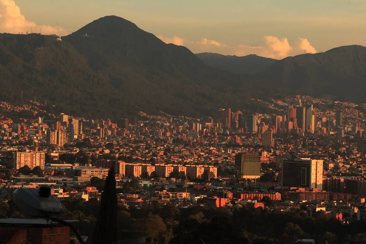
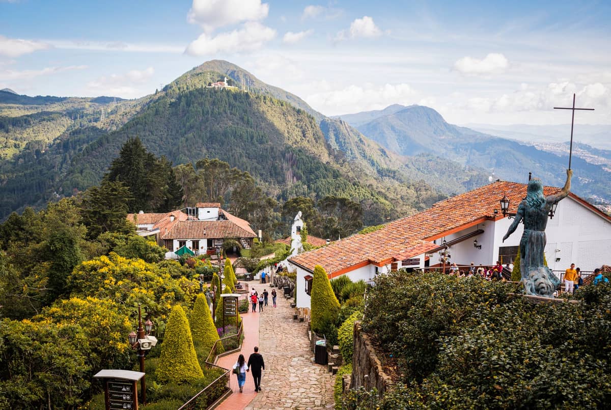
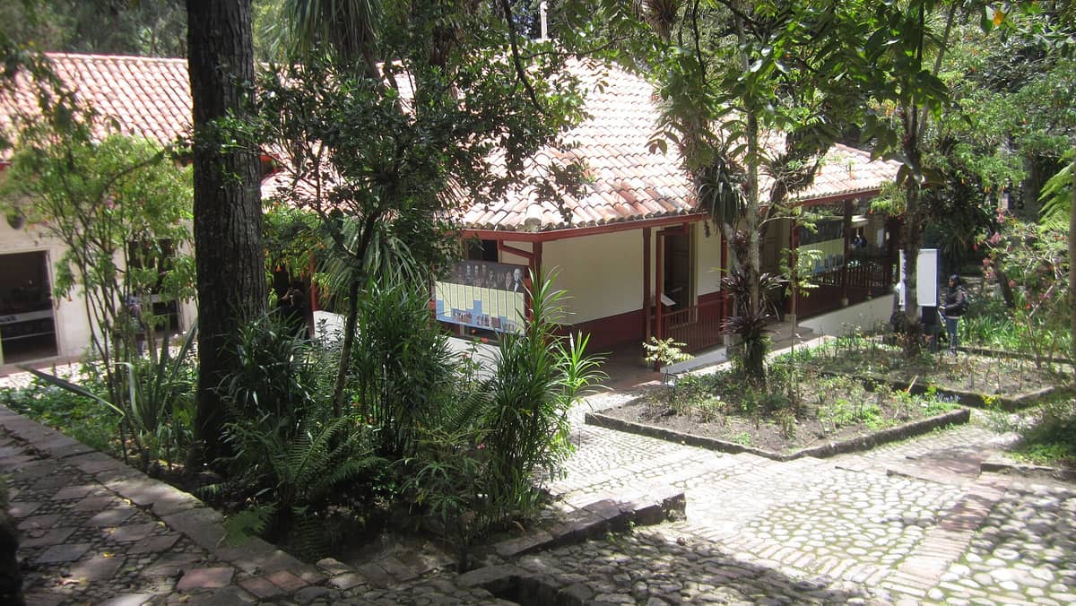
The Cerros Orientales are the forested mountain range that forms Bogotá's entire eastern boundary, stretching from Usme in the south to Usaquén in the north. More than a scenic backdrop, this 13,142-hectare protected reserve is a functioning ecological corridor, a trail network, and the physical reason Bogotá cannot grow eastward. For visitors, it is the city's most accessible wilderness, minutes from the urban grid.
Bogotá's eastern skyline is defined not by towers but by mountains: the Cerros Orientales, a forested ridge that rises sharply above the city and holds it in place like a green wall. Protected as the Reserva Forestal Protectora Bosque Oriental de Bogotá, these hills are where the urban fabric abruptly ends and cloud forest begins, offering trails, sweeping city views, and a daily reminder that Bogotá sits at 2,640 metres above sea level on the edge of the Andes.
Orientation: Where the City Ends and the Mountain Begins
The Cerros Orientales run in a long north-south arc along the entire eastern edge of Bogotá, D.C., spanning the localities of Usme, San Cristóbal, Santa Fe, Chapinero, and Usaquén. This is not a single peak or a small park: the Reserva Forestal Protectora Bosque Oriental de Bogotá covers roughly 14,116 hectares, making it one of the largest urban forest reserves in Latin America. The reserve's western limit is the city itself: in most stretches, streets simply stop at the foot of the slope, and the mountain takes over.
Between the consolidated urban neighborhoods and the forest reserve proper lies a regulated transition zone called the Franja de Adecuación, defined by Ministry of Environment Resolution 463 of 2005. This strip runs the full length of the mountains and is mapped into intervention sectors with names such as Soratama, Parque del Agua, Villa del Cerro, and Tihuaque-Las Violetas. These sectors function as buffer zones intended for controlled recreation, environmental education, and ecological recovery rather than development.
The two most recognizable summits on the ridge are Monserrate and Guadalupe, which tower above central Bogotá and the historic district of La Candelaria. Monserrate sits at approximately 3,152 metres and is the single most visited point in the entire Cerros system. North of the main ridge, the mountains continue toward Usaquén; south, they descend through San Cristóbal toward Usme. Carrera 7 (La Séptima) runs roughly parallel to the mountains a few blocks to the west and is the most useful orientation axis for understanding where you are relative to the hills.
ℹ️ Good to know
The Cerros Orientales are not a conventional neighborhood with shops and streets. They are a legally protected forest reserve and a set of transition zones where public access is managed under an environmental management plan (Plan de Manejo Ambiental, Resolution 1766 of 2016). Expect trailheads, viewpoints, and regulated paths rather than a traditional urban district.
Character and Atmosphere: A City in the Shadow of the Andes
From any flat rooftop or elevated street in central Bogotá, the Cerros Orientales are the constant presence on the horizon: dark green in the morning fog, vivid when the clouds clear after midday rain, lit a faint amber by streetlights at night. The mountains give Bogotá its cardinal directions in a city where standard compasses often feel unreliable. If the cerros are on your right, you are heading north. If they are behind you, you are moving west. Most long-term residents navigate this way without thinking.
Early morning on the slopes is cool and quiet, often running five or six degrees colder than the city centre below. Cloud forest moisture clings to the trails before 8 a.m., and the calls of birds you would never hear on a Bogotá street fill the air around the higher trailheads. Serious trail runners and cyclists who make the climb before work are often the only people around at that hour. By mid-morning on weekends, the lower access points fill with families and groups of friends making the walk to Monserrate.
Afternoons can bring fast-moving cloud cover rolling in from the east, dropping temperatures rapidly and soaking the upper trails. This is the rhythm of a highland climate: brilliant clarity before noon, cloud build-up through the afternoon, brief heavy rain, then a cool clear evening. The light that falls on the cerros in the hour before sunset, when the clouds break and the city below is still in shadow, is one of the more striking sights available without leaving the urban area.
The contrast between the mountain and the city directly below it is part of what makes the Cerros feel so distinct. In some sectors, wealthy residential streets climb into the Franja de Adecuación, with high-walled properties ending at the forest edge. In others, informal settlements occupy the lower slopes in zones that long predate the environmental regulations. This tension between conservation, habitation, and recreation is ongoing and visible to anyone paying attention.
What to See and Do
The dominant attraction in the entire Cerros system is Cerro de Monserrate, the sanctuary-topped peak visible from almost anywhere in central Bogotá. You can reach the summit on foot via a well-maintained pilgrimage path The dominant attraction in the entire Cerros system is Monserrate, the sanctuary-topped peak visible from almost anywhere in central Bogotá. You can reach the summit on foot via a well-maintained pilgrimage path, by cable car (teleférico), or by funicular railway. The walk takes between 45 minutes and an hour and a half depending on fitness; the altitude makes itself felt at every step. At the top, the sanctuary of El Señor Caído draws both pilgrims and tourists, and the view across the urban grid of Bogotá is genuinely panoramic.
Beyond Monserrate, the Cerros contain a network of trails within the reserve and the Franja de Adecuación that are used for hiking, trail running, and birdwatching. The sector around Parque del Agua and the trails connecting northward through Chapinero toward Usaquén offer longer routes through native cloud forest. The reserve shelters significant bird diversity, including several species endemic to the Eastern Andes, which draws birdwatchers in the early hours of the morning.
For those interested in urban cycling culture, the Cerros are directly connected to Bogotá's broader cycling infrastructure. The city's famous Ciclovía network connects neighborhoods at the foot of the hills, and some roads climbing into the Franja are popular with experienced road cyclists willing to negotiate the altitude and gradient.
Hike the pedestrian path to Monserrate: open daily, with the trail closed on Tuesdays for maintenance; cable car and funicular run on their published schedule
Birdwatching in the cloud forest sectors, best before 9 a.m. on weekdays when trails are quiet
Trail running circuits in the Franja de Adecuación, with access points near Chapinero and Santa Fe
Sunrise viewpoints above the city, particularly compelling in the dry season (December to March and July to August)
Photography of the city skyline from the upper slopes at different times of day
⚠️ What to skip
Access to specific trails and sectors within the Reserva Forestal is regulated under the Plan de Manejo Ambiental. Environmental authorities periodically close or restrict routes for ecological recovery or safety reasons. Always check posted signs at trailheads and verify current access conditions before heading into the reserve, especially after heavy rainfall.
Eating and Drinking: Fueling Up Before and After the Climb
There are no restaurants or cafés inside the Reserva Forestal itself, and the Franja de Adecuación restricts commercial development. Eating and drinking options are concentrated at specific access points, particularly around the base of Monserrate and in the urban streets immediately below the mountain.
At the summit of Monserrate, there are a few food and drink options oriented toward pilgrims and tourists, including Colombian staples such as ajiaco and hot chocolate with almojábanas. These are functional and pleasant enough after the climb but not destinations in themselves. Prices at the summit run noticeably higher than at street level below.
For a proper meal before or after the cerros, the sensible approach is to head into the neighborhoods at the foot of the mountains. La MacarenaLa Candelaria sits at the base of the hills in the Santa Fe locality and has a genuine concentration of good restaurants, cafés, and bars within a short walk of the Monserrate access point. The neighborhood has built a reputation as one of Bogotá's better dining areas without the formality of Zona G or the crowds of Zona Rosa.
Further north, in the Chapinero and Usaquén sectors that border the Cerros, there are good coffee shops and neighborhood restaurants along the streets closest to the hills. For a wider overview of the Bogotá food scene connected to these areas, the Bogotá food guide covers the major dining districts with specific recommendations by price range and cuisine type.
💡 Local tip
Carry water and a snack if you plan to hike beyond the Monserrate summit. The trail network in the reserve has no food vendors, and dehydration at altitude is a real concern, especially for visitors who have just arrived in Bogotá and have not yet acclimatized to 2,640 metres.
Getting There and Around
The Cerros Orientales are accessible from multiple points along their western face, and the approach depends on which sector you want to reach. For Monserrate and the southern Cerros, the most direct access from central Bogotá is via the base station above La Candelaria, at the foot of the mountain on the east side. From Plaza de Bolívar, this is roughly a 15-20 minute walk heading east along Calle 11 or Calle 14 toward the mountain.
TransMilenio, Bogotá's bus rapid transit system, is the main public transport option for reaching the foot of the Cerros. Several trunk lines run along major north-south corridors such as Avenida Caracas, Autopista Norte, and NQS, with feeder services connecting to streets at the base of the hills. Carrera 7 itself is not a full TransMilenio trunk. The getting around Bogotá guide covers the full TransMilenio network and how to read routes. Ride-hailing apps including Uber, Cabify, and Didi are the most convenient option for reaching specific access points, particularly for the northern Cerros sectors near Chapinero or Usaquén.
Once at the base, navigation is straightforward: the mountain is always uphill to the east. The Monserrate access station has clear signage for the pedestrian path, the funicular, and the cable car. For other sectors of the reserve, trailhead access points are typically marked, though signage quality varies. A topographic map app with offline capability is worth having for any hiking beyond the main Monserrate route.
The funicular and teleférico at Monserrate operate on a restricted schedule: The funicular and teleférico at Monserrate operate on a published schedule that varies by day of week and holidays. The pedestrian path operates daily except Tuesdays, when it closes for maintenance. Verify the current schedule and ticket prices before visiting, as these are subject to change.
Where to Stay Near the Cerros Orientales
There is no accommodation inside the reserve, and the Franja de Adecuación restricts new development. Travelers wanting easy access to the Cerros should base themselves in La Candelaria for the closest approach to Monserrate, or in La Macarena and Santa Fe for a balance between access to the hills and a walkable neighborhood with restaurants and cafés. Further north, Chapinero offers access to the mid-mountain trail sectors with a wider range of accommodation options from budget hostels to boutique hotels.
For those prioritizing the Cerros as a day-trip destination rather than a base, it is also realistic to stay in the northern business and hotel districts and take a ride-hailing app to whichever trailhead you want. The full where to stay in Bogotá guide maps out the accommodation landscape across the city's major neighborhoods with guidance on which area suits which type of traveler.
Practical Considerations: Altitude, Safety, and Regulations
Bogotá already sits at 2,640 metres above sea level. The Cerros push well beyond that: the summit of Monserrate is at roughly 3,152 metres, and some hiking routes go higher. Altitude affects most visitors to some degree, especially in the first day or two. The Bogotá altitude guide covers acclimatization in detail, but the short version is: take it slowly, drink water consistently, and do not push hard on the hiking trails on your first full day in the city.
Safety on the main Monserrate trail is generally good during daylight hours when other hikers and visitors are present. The path is regularly used and visible throughout. More isolated trail sectors in the reserve require more caution: go with others, tell someone your plan, and avoid remote routes in poor weather or fading light. For general guidance on navigating Bogotá safely, the Bogotá safety tips guide provides current and practical advice.
The Reserva Forestal Protectora Bosque Oriental de Bogotá operates under a Plan de Manejo Ambiental overseen by the Corporación Autónoma Regional de Cundinamarca (CAR) and the Secretaría Distrital de Ambiente. Permitted activities within the reserve and the Franja de Adecuación are defined by regulation and include conservation, environmental education, and passive and active recreation. Construction and commercial activity are strictly restricted. Visitors are expected to stay on marked paths, take all waste out with them, and respect any closures posted by environmental authorities.
Weather changes fast at this elevation. Clear skies at 9 a.m. can become cold rain by early afternoon, particularly in the rainy seasons of April-May and September-November. Layer clothing appropriate for temperatures that may drop 8-10 degrees within the same day. A light waterproof layer is useful year-round on the upper slopes.
TL;DR
The Cerros Orientales are Bogotá's eastern mountain boundary: a 14,116-hectare protected cloud forest reserve running the full length of the city from Usme to Usaquén.
The main visitor draw is Cerro de Monserrate, reachable on foot (free on weekdays) or by funicular and cable car (Thursday through Sunday and holidays).
This is an outdoor and nature destination, not a neighborhood with hotels, restaurants, or shops inside it: plan eating and staying in adjacent areas like La Macarena, La Candelaria, or Chapinero.
Altitude is a real factor: the Monserrate summit sits at over 3,150 metres, well above an already high city. Acclimatize before attempting the walk up.
Best suited to: hikers, trail runners, birdwatchers, photographers, and anyone who wants to understand why Bogotá looks and feels the way it does. Not suited to visitors looking for urban nightlife, shopping, or an all-in-one neighborhood base.
Three days is enough to get a real feel for Bogotá, D.C. — Colombia's high-altitude capital of roughly 8 million people. This itinerary covers the historic core, world-class museums, the city's best neighborhoods, and one excellent day trip, with honest logistics and timing built in.
Bogotá holds its own as a museum city. From world-class pre-Columbian collections to free art galleries and immersive history museums, these are the institutions that make the Colombian capital one of Latin America's most rewarding cultural destinations.
Bogotá's climate stays mild year-round thanks to its 2,640 m elevation, but the best time to visit depends on your priorities. This guide breaks down dry seasons, rainy periods, major festivals, crowd levels, and what no one tells you about Bogotá's weather.
Everything you need to navigate El Dorado International Airport (BOG) and reach central Bogotá efficiently. From TransMilenio routes and TuLlave cards to regulated taxi fares and private transfers, this guide covers every option with real prices and clear trade-offs.
At 2,640 metres above sea level, Bogotá is one of the highest capital cities in the world. This guide covers everything you need to know: altitude sickness symptoms, prevention strategies, UV risks, seasonal weather patterns, and practical tips for arriving healthy and staying comfortable.
Every Sunday and public holiday, Bogotá closes over 127 km of city streets to cars and opens them to cyclists, runners, skaters, and walkers. This is your complete guide to the Ciclovía: how it works, where to ride, what to expect, and how to make the most of it.
Bogotá, Colombia has quietly become one of Latin America's most practical bases for remote workers. This guide covers real monthly budgets, coworking space prices, the best neighborhoods to live and work from, and what no one tells you before you land at El Dorado.
Bogotá's food scene runs deeper than most visitors expect. This guide covers the city's signature dishes, where to find them by neighborhood, what to skip, and how to eat like someone who actually lives there.
December is one of the best months to visit Bogotá, D.C. The city enters its drier season, temperatures are mild, and the famous Ruta de la Navidad transforms entire districts into illuminated corridors. Here is everything you need to plan your visit.
Bogotá's nightlife scene runs deep and late, from craft beer bars in Chapinero to high-end mixology lounges in Zona T. This guide breaks down the best areas, what to spend, when to go, and what to watch out for.
Bogotá, Colombia gets a bad reputation that doesn't tell the full story. This guide breaks down the real risks by neighborhood, time of day, and situation — so you can travel smart, not scared.
Bogotá, D.C. offers one of South America's most varied shopping landscapes, from pre-dawn flower markets and weekend craft fairs to polished upscale malls. This guide covers where to shop, what to buy, what things cost, and how to avoid the common mistakes that waste both time and money.
Bogotá, D.C. has built one of Latin America's most serious street art scenes, with politically charged murals, internationally recognized artists, and organized tours running daily across multiple neighborhoods. This guide covers where to go, which tours are worth your money, and what to know before you walk out the door.
Bogotá, Colombia sits at 2,640 metres above sea level, which means the city defies every tropical climate stereotype. Temperatures hover in a narrow band year-round, but two distinct rainy seasons shape when and how you should visit. This guide breaks down the month-by-month reality, what to pack, and when crowds and prices peak.
Bogotá, D.C. is a surprisingly rewarding destination for families. From free city museums and mountaintop adventures to cycling days and colonial history, this guide covers the best kid-friendly activities in Bogotá, Colombia, with real prices, practical logistics, and notes on what works with children of different ages.
Bogotá, D.C. has become one of Latin America's most serious specialty coffee cities, with farm-to-cup roasters, barista workshops, and day trips to working coffee farms all within reach. This guide covers where to drink, what to order, what to avoid, and how to get the most out of Colombian coffee culture in the capital.
Bogotá, D.C. sits at 2,640 m above sea level in the heart of the Colombian Andes, making it an ideal base for exploring some of South America's most distinctive landscapes and colonial heritage. This guide covers the top day trips from Bogotá with practical transport details, realistic timings, and honest assessments of what each destination actually delivers.
Bogotá offers a surprising number of free experiences. From permanently free world-class museums to weekly car-free streets, colonial plazas, and sprawling urban parks, the city rewards travelers who know where to look. This guide covers the best no-cost activities, with clear notes on when free access applies.
Bogotá, D.C. has one of Latin America's most extensive urban transit networks, but navigating it takes some preparation. This guide covers TransMilenio, SITP buses, the TransMiCable, taxis, ride-hailing apps, and airport transfers — with current fares, practical tips, and clear notes on what works and what to avoid.
Bogotá, D.C. is one of South America's most underrated capitals. This guide covers the best things to do in Bogotá across culture, food, neighborhoods, and day trips, with current prices, opening hours, and practical notes on what to skip.
Choosing where to stay in Bogotá shapes your entire trip. This guide breaks down every major neighborhood by safety, price range, atmosphere, and proximity to key attractions, so you can book with confidence.