Mount Pleasant is the neighbourhood where Vancouver's creative class put down roots, turning a working-class industrial district into a corridor of craft breweries, independent coffee roasters, vintage stores, and murals that cover entire building facades. Anchored by Main Street running north to south, it sits just south of False Creek and feels distinctly unhurried compared to downtown, two kilometres to the northwest.
Mount Pleasant is Vancouver's most creatively charged neighbourhood, where former warehouses and corner lots now house craft breweries, independent galleries, and some of the city's best coffee. Main Street is the spine of it all, a long, walkable strip that shifts in character block by block, from design studios near False Creek down to quiet residential stretches approaching 16th Avenue.
Orientation
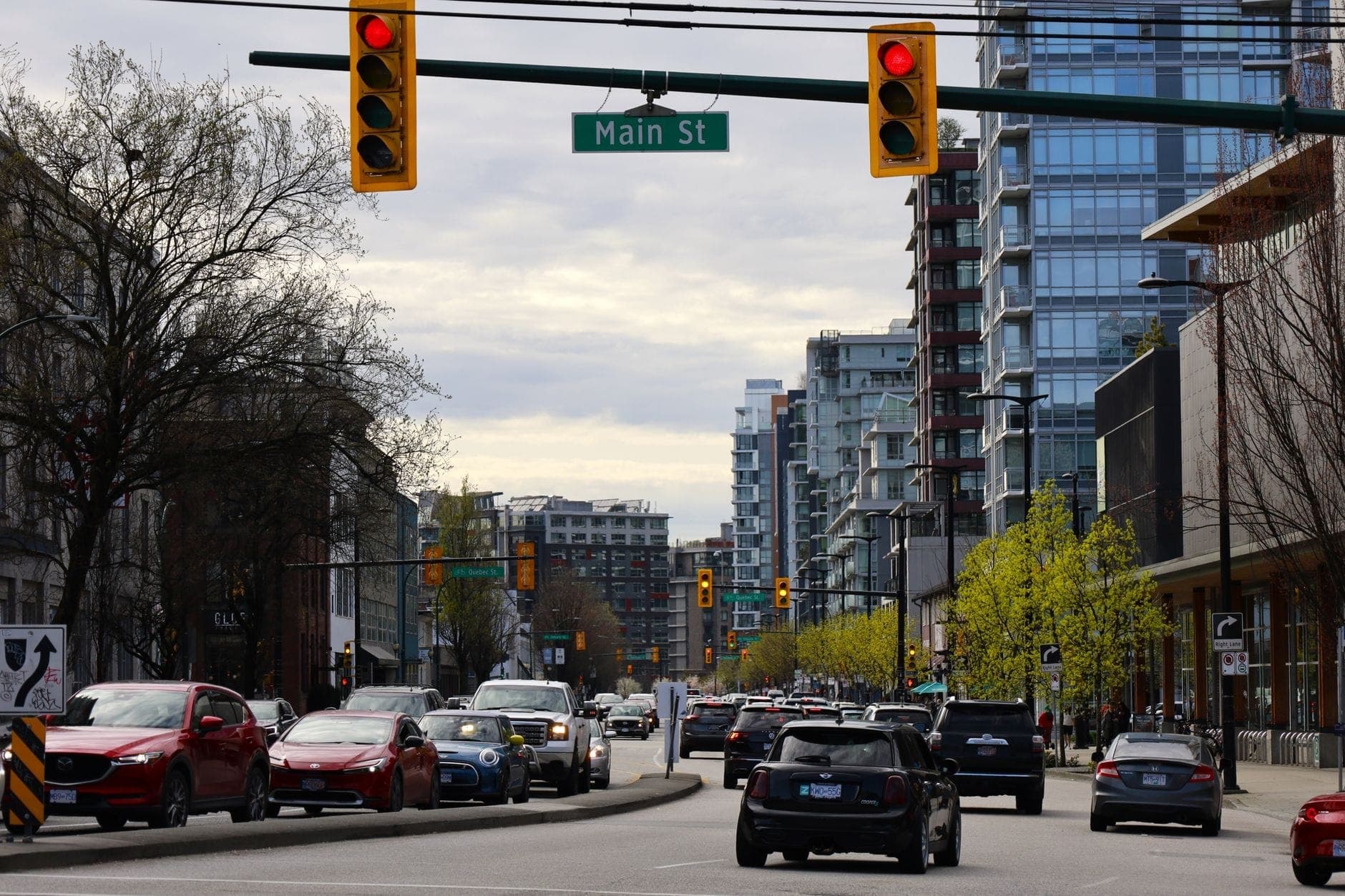
Mount Pleasant occupies a roughly rectangular footprint south of False Creek, with Clark Drive forming its eastern edge, Cambie Street its western boundary, 16th Avenue to the south, and Great Northern Way and the False Creek Flats roughly defining its northern edge, though some official city maps extend the boundary slightly north toward 2nd Avenue in parts. Main Street bisects the neighbourhood north to south, running from the edge of the Flats all the way down past the neighbourhood's southern limits. If you have a single street to fix in your mental map, that is it.
The neighbourhood sits on gently rising ground. Walking south from the False Creek Flats, the streets climb incrementally, which gives some of the cross streets pleasant views back toward downtown. City Hall, the imposing Art Deco building at Cambie and 12th Avenue, sits just outside the neighbourhood's northwestern corner and serves as a useful landmark. Broadway, the city's main east-west commercial artery, cuts across the northern portion of Mount Pleasant and connects the area quickly to the Fairview and Kitsilano neighbourhoods to the west.
The neighbourhood is sandwiched between well-known Vancouver districts. To the north, across False Creek, sits Yaletown. To the west, once you cross Cambie, you enter Fairview and then the slopes toward Kitsilano. East of Clark Drive, the character shifts into Commercial Drive and the Grandview-Woodland neighbourhood. Understanding these adjacencies helps: Mount Pleasant is not on the tourist circuit in the way that Gastown or Granville Island are, which is precisely why many travellers find it more rewarding.
Character & Atmosphere
On a weekday morning, Main Street has a specific rhythm. The coffee shops fill early, mostly with people who actually live here: designers, tradespeople, remote workers, and the occasional parent with a stroller navigating the uneven sidewalk. The light comes in at a low angle, catching the painted murals on the sides of buildings, some of them large-scale commissioned works, others clearly improvised. There is little in the way of tourist signage or souvenir shops. Storefronts are independent and idiosyncratic, a taxidermy artist next to a ramen spot next to a vintage clothing dealer with a handwritten chalk sign.
By mid-afternoon on weekends, the energy shifts noticeably. The strip between 7th and Broadway becomes busy with people browsing record stores and plant shops, and the brewery taprooms start filling with groups who have clearly been here before and know exactly which table they want. Guelph Park, known locally as Dude Chilling Park after a now-legendary sign installation, fills with people on warm days. The park's name alone tells you something about the neighbourhood's relationship with its own identity: self-aware, a little ironic, but genuinely community-oriented.
After dark, Mount Pleasant is calm rather than rowdy. The taprooms and restaurants run late, but the neighbourhood is not a nightlife district in the way Granville Street is. You are more likely to hear a band playing inside a bar than to encounter loud groups outside. Walking south from Broadway past 10th Avenue, the streets quiet down considerably, and by 14th Avenue you are deep in residential territory where the main sound is birdsong and the occasional skateboard.
ℹ️ Good to know
Mount Pleasant went through significant change from the 1990s onward, attracting artists and small businesses to what had been a post-industrial district. The concentration of breweries, in particular, happened quickly enough that local guides now refer to the area around Main and 7th as an informal 'brewery district.' That evolution continues today, with tech offices and co-working spaces occupying the former industrial buildings north of Broadway near Great Northern Way.
What to See & Do
The most rewarding way to spend time in Mount Pleasant is simply to walk Main Street from Broadway down to around 16th Avenue and take stock of what catches your attention. The street is lined with independent businesses, public art installations, and the kind of detailed street-level architecture that rewards slow walking. Look up occasionally: rooflines, painted brick, and corner turrets from early 20th century buildings are scattered throughout.
Guelph Park at 7th and Guelph Street is worth a stop, especially if you are visiting with children or want a break from walking. The painted 'Dude Chilling' sign is a neighbourhood institution, a play on a Tom Burrows sculpture called Reclining Figure installed in the park. Robson Park, a smaller green space nearby, is quieter and more residential in feel. For a bigger green space, Queen Elizabeth Park is an easy bus ride or cycle south along Cambie.
The area around Great Northern Way, along the northern edge of the neighbourhood, has become a hub for creative industry. If you are interested in how Vancouver's art and design scene operates outside of gallery spaces, this stretch is worth a look. For more formal gallery experiences, the art galleries in Vancouver guide covers the broader city picture, but Mount Pleasant itself has several small commercial galleries mixed in among the shops on Main Street.
Walk Main Street from Broadway to 16th Avenue, taking in the independent storefronts and murals
Visit Guelph Park (Dude Chilling Park) at 7th Avenue for the neighbourhood's most-photographed landmark
Tour the cluster of brewery taprooms around Main and 7th to 12th Avenue
Browse the vintage and second-hand shops concentrated between 15th and 20th Avenue on Main
Check out the public art installations along the False Creek Flats at the neighbourhood's northern edge
Cycle the local bike routes that cross-hatch the neighbourhood's residential blocks
💡 Local tip
The brewery taprooms in Mount Pleasant do not require reservations for small groups on weekday evenings. On weekend afternoons, expect to wait for a table at the most popular spots. Arriving before 3pm or after 7pm gives you the best chance of settling in without a wait.
Eating & Drinking
Main Street's food and drink scene is one of the more honest eating strips in Vancouver. Prices are lower than Yaletown or South Granville, the cooking tends to be direct and ingredient-focused rather than concept-driven, and the turnover of restaurants is high enough that the survivors are genuinely good. The cuisine mix runs from Japanese ramen and Vietnamese pho at the affordable end to natural wine bars and small-plates restaurants at the mid-range, with very little in the way of chain dining.
Coffee is taken seriously here. Several of Vancouver's most respected independent roasters have their cafes on or near Main Street, and the competition has raised the standard for the neighbourhood as a whole. Weekend mornings see queues at the most popular spots, but the density of good options means you are never more than a block from a solid flat white. Most cafes double as community spaces, with local art on the walls, plants in the windows, and tables that people occupy for hours.
The brewery culture deserves its own mention. The concentration of craft breweries in Mount Pleasant is one of the highest of any neighbourhood in the city, and most of them operate taprooms with rotating tap lists, food menus, and dog-friendly patios. They range from small neighbourhood spots to larger operations that also do brewery tours and retail sales. For visitors who want to get a sense of Vancouver's craft beer scene without committing to a tour, an afternoon walking between two or three taprooms on Main covers the ground well.
For a broader guide to Vancouver's food culture and what dishes to prioritize, the what to eat in Vancouver guide gives useful context. Mount Pleasant fits within Vancouver's wider reputation for Pacific Northwest cuisine, strong Asian food traditions, and independent dining culture, but it expresses those influences in a distinctly neighbourhood-scale way.
Getting There & Around
Mount Pleasant is well connected to the rest of Vancouver without being on a SkyTrain line itself. The closest rapid transit station is Broadway–City Hall at Cambie and Broadway on the Canada Line, with a Millennium Line extension station at the same intersection currently under construction. From there, Main Street is a ten-minute walk east along Broadway. The Canada Line stops at Broadway–City Hall, making it a direct connection from Vancouver International Airport, typically around 25 to 30 minutes by rail depending on time of day.
TransLink bus routes serve Main Street directly, with frequent services running the length of the corridor north to south. The 3 Main bus runs from Waterfront Station downtown all the way south through the neighbourhood, making it a straightforward single-vehicle trip from the city centre. The 99 B-Line (to be renamed/transitioned to the 99 UBC–Commercial B-Line service as part of the Broadway Subway integration) runs along Broadway and stops at the northern edge of the neighbourhood, connecting quickly to both UBC to the west and Commercial–Broadway Station to the east.
Cycling is genuinely convenient here. The neighbourhood has a well-developed network of low-traffic bike routes on residential streets running parallel to the main arterials. If you are using a bike share (Mobi by Shaw Go operates in Vancouver), there are stations on Main Street and in adjacent blocks. Riding from Yaletown or the Cambie Street Bridge to Main Street is a direct and mostly flat route of around ten minutes.
For a full picture of how to navigate Vancouver by transit, bike, and on foot, the getting around Vancouver guide covers TransLink fares, SkyTrain zones, and bike share details in one place. Fares and zone structures change periodically, so verify current pricing with TransLink before travel.
💡 Local tip
If you are staying in downtown Vancouver, the most pleasant way to reach Main Street on a good-weather day is to walk or cycle south along the Cambie Street corridor or across the Cambie Bridge and then east. The route passes through Yaletown and along the False Creek seawall, adding a scenic element to what would otherwise be a functional transit trip.
Where to Stay
Mount Pleasant is not a hotel-dense neighbourhood. The accommodation options here lean toward boutique properties, apartment-style rentals, and smaller independent guesthouses rather than the large hotel towers found downtown or near Canada Place. For travellers who prioritize neighbourhood character over hotel amenities, this works in its favour. You are more likely to wake up to the sounds of a real neighbourhood, grab a coffee from a genuinely local café, and walk to dinner without wading through tourist infrastructure.
The neighbourhood suits independent travellers, couples, and anyone who already has a handle on how to navigate Vancouver by transit. It is less suited to first-time visitors who want walking access to the main landmarks, since Stanley Park, Gastown, and Granville Island all require transit or cycling from here. Families with young children may find the limited proximity to the main waterfront attractions a drawback, though the local parks and the easy bike route to the False Creek seawall offset that somewhat.
If you are weighing Mount Pleasant against other neighbourhoods, the where to stay in Vancouver guide compares the city's main areas by traveller type, price range, and proximity to attractions. For most first-time visitors, staying closer to downtown remains the more practical choice.
⚠️ What to skip
The False Creek Flats area along the neighbourhood's northern boundary, particularly around Great Northern Way and the industrial blocks east of Main, is a mixed-use transitional zone that is undergoing significant development. At night this area is quiet and poorly lit in parts. If you are walking back to accommodation in the neighbourhood after an evening out in Gastown or downtown, it is worth sticking to Main Street itself rather than cutting through the Flats.
Drawbacks to know
Mount Pleasant is not a neighbourhood for travellers who want to see Vancouver's headline sights on foot. From Main and Broadway, it takes around 30 minutes by transit to reach Stanley Park, Granville Island involves a bus and ferry or a longer cycle, and the North Shore mountains require crossing the inlet. If your trip is short and landmark-focused, basing yourself here adds friction to your days.
The strip along Main Street between roughly Broadway and 7th Avenue is the social and commercial core. South of around 14th Avenue, the neighbourhood becomes primarily residential and quieter, with fewer restaurants and shops. If you are staying toward the southern end of the neighbourhood, expect a walk or short bus ride to reach the more active section of Main Street.
Travellers seeking a comprehensive sense of Vancouver's safety landscape across different neighbourhoods should consult the Vancouver safety guide and check current information from the City of Vancouver, as conditions can change and the overall picture varies by block and time of day.
TL;DR
Mount Pleasant is Vancouver's best neighbourhood for independent coffee, craft beer, vintage shopping, and street-level creativity, anchored by Main Street between Broadway and 16th Avenue.
Best suited to independent travellers, return visitors to Vancouver, or anyone who prefers neighbourhood life over hotel-district convenience.
Not ideal for first-time visitors who want walkable access to Stanley Park, Granville Island, or the downtown waterfront, all of which require transit from here.
Broadway–City Hall SkyTrain station (Canada Line, with a Millennium Line extension station under construction) is the main transit gateway, about ten minutes' walk from the heart of Main Street.
The brewery taproom cluster around Main and 7th Avenue is the neighbourhood's most distinctive draw and a good introduction to Vancouver's craft beer scene without committing to a formal tour.
Three days is enough time to cover Vancouver's best neighbourhoods, waterfront parks, and mountain views without feeling rushed. This itinerary organizes the city logically by geography, cuts out the tourist traps, and works whether you're on foot, SkyTrain, or a borrowed bike.
Vancouver's art scene spans a former provincial courthouse turned major museum, an intimate Haida gallery downtown, a world-class anthropology collection at UBC, and a full gallery district along South Granville. This guide covers the best art galleries in Vancouver for every interest and budget.
Vancouver has over 18 kilometres of oceanfront beaches, from lively urban strands with mountain backdrops to tidal flats perfect for families. This guide covers every beach worth your time, with clear notes on what to expect at each one.
Vancouver's museum scene spans world-class Indigenous art collections, civic history, space science, maritime heritage, and forensic curiosities. These are the best museums in Vancouver, organized by theme and neighbourhood, with practical tips for each.
Vancouver's temperate oceanic climate means it's visitable year-round, but each season offers a completely different experience. This guide breaks down weather, crowds, hotel prices, and key events by season so you can pick the right time for your trip.
Vancouver is one of the most visually dramatic cities in the world, where a downtown skyline meets ocean inlets and snow-capped peaks. This guide covers the best viewpoints across the city, from free hilltop parks and seawall walks to mountaintop gondolas and elevated observation decks.
Vancouver's garden scene ranges from a world-class 55-acre botanical garden to an authentic Japanese tea garden and a tropical conservatory open year-round. This guide covers every significant plant-focused attraction in the city, with notes on the best seasons to visit each.
Vancouver sits at the gateway to some of the most dramatic scenery in North America. Whether you head north toward Whistler, west to Vancouver Island, or east into the Fraser Valley, these are the best day trips from Vancouver, with realistic travel times, transport options, and what to prioritise once you arrive.
Vancouver is one of Canada's most expensive cities, but a remarkable number of its best experiences cost nothing. These 22 free activities cover Stanley Park, beaches, North Shore hikes, waterfront walks, and neighbourhood explorations across the city.
Vancouver's transit network is one of the best in North America, but navigating zones, passes, and peak hours takes some planning. This guide covers every mode of transport, from the Canada Line SkyTrain to cycling the seawall, with current fares and practical tips on when to skip the car entirely.
Vancouver sits at the edge of one of the most dramatic hiking landscapes in North America. These are the best trails near the city, from steep North Shore climbs to peaceful forest walks, chosen for scenery, accessibility, and what makes each one worth the effort.
Vancouver delivers a compelling luxury travel proposition: world-class 5-star hotels steps from the waterfront, a dining scene that punches well above its size, and wilderness experiences that no other major city can match. This guide covers where to stay, when to book, what to spend, and how to get the most out of high-end Vancouver.
Vancouver packs an extraordinary range of experiences into a compact, walkable city on Canada's Pacific coast. This guide covers the best things to do in Vancouver BC, from iconic outdoor adventures to neighbourhood deep-dives, with practical assessments, current pricing context, and logistics to help you make the most of your time.
Vancouver hosts one of Canada's largest Lunar New Year celebrations, anchored by a 1.3 km parade through historic Chinatown and a full 15-day festival season. This guide covers the parade route, top events across Metro Vancouver, transport logistics, and what first-timers often get wrong.
Vancouver sets a high bar for romantic travel. Mountains meet ocean, world-class restaurants sit steps from forested trails, and the city shifts beautifully with every season. This guide covers the best things to do in Vancouver BC for couples, from free waterfront walks to splurge-worthy experiences worth every dollar.
December transforms Vancouver into one of Canada's most festive winter cities, with major light displays, Christmas markets, and ice skating — all against a backdrop of mild, rainy Pacific weather. This guide covers everything you need to plan a December visit, from the best seasonal events to practical logistics.
Summer is Vancouver's best season by most measures: dry weather, long daylight hours stretching past 9 pm, and a calendar packed with outdoor events. This guide covers what to do each month, how much it costs, where crowds get bad, and what the city actually feels like when temperatures hit their annual peak.
Getting from Vancouver to Vancouver Island is straightforward once you know which route to take, when to book, and what to expect on the water. This guide covers every BC Ferries route, current fare ranges, reservation rules, and practical tips for making the most of a day trip or longer stay.
Vancouver's after-dark scene spans gritty dance clubs on the Granville Strip, polished cocktail lounges in Yaletown, independent craft beer bars on Main Street, and live music in Gastown. This guide breaks down where to go, what to expect, and how to avoid a bad night out.
Vancouver has a reputation for being pricey, and on accommodations and dining, that reputation is earned. But a huge share of what makes the city worth visiting costs nothing at all. This guide breaks down real daily costs, the best free attractions, affordable food strategies, and how to get around without spending a fortune.
Vancouver is one of Canada's most visited cities, and for good reason. But visitors increasingly ask: is Vancouver safe? This guide uses recent crime data, neighborhood-by-neighborhood context, and practical tips so you can explore with confidence.
The Vancouver Seawall is the world's longest uninterrupted waterfront path, stretching about 22 km along the waterfront from Coal Harbour to Kitsilano Beach, with some sources including extensions out to roughly 28–30 km. This guide covers every section of the route, cycling rules, seasonal conditions, rental options, and the best spots to stop along the way.
Vancouver's shopping scene spans luxury boutiques on Alberni Street, 330-store malls reachable by SkyTrain, a working public market on a former industrial island, and independent-label strips on Main Street and Commercial Drive. This guide breaks down every major option by neighbourhood, budget, and transit access so you can shop smarter.
Vancouver is one of the most approachable solo travel destinations in North America. From the Stanley Park Seawall to Granville Island's food stalls, this guide covers everything you need to plan a confident, well-timed solo trip to British Columbia's Pacific coast city.
The trip from Vancouver to Calgary covers roughly 970 km and can be done by plane, car, or bus. Each option has real trade-offs. This guide breaks down the costs, logistics, and seasonal considerations so you can choose the route that actually works for your trip.
The Vancouver to Seattle corridor is one of the most-traveled cross-border routes in North America. Whether you're driving I-5, riding the Amtrak Cascades train, or taking a budget coach, this guide breaks down travel times, costs, border logistics, and the smartest ways to avoid delays.
Everything you need to plan the Vancouver to Whistler drive via Highway 99, including key stops along the Sea to Sky corridor, shuttle alternatives, winter driving laws, and the best times to make the trip. Whether you're heading up for ski season or a summer adventure, this guide covers it all.
Vancouver's temperate oceanic climate means mild, rainy winters and warm, relatively dry summers — but the details matter for trip planning. This guide breaks down Vancouver weather month by month, covering temperatures, precipitation, crowd levels, and what to pack for every season.
From Stanley Park playgrounds to Science World and the Granville Island Kids Market, Vancouver delivers serious family value across every budget and season. Practical logistics, clear assessments, and the specific details parents actually need.
Vancouver's food scene is one of the most diverse in North America, shaped by Pacific seafood, deep Asian culinary traditions, and a thriving modern restaurant culture. This guide breaks down what to eat, where to eat it, and what to skip across the city's best food neighborhoods.
Choosing where to stay in Vancouver shapes your entire trip. This guide covers every major neighbourhood, realistic price ranges, seasonal timing, and clear trade-offs so you can match your accommodation to how you actually plan to spend your days.