Parco Nazionale del Golfo di Orosei e del Gennargentu: Sardinia's Wild Interior
Covering roughly 74,000 hectares of rugged mountain, gorge, and coastal wilderness in central-eastern Sardinia, the area commonly referred to as Gennargentu National Park is the island's most ambitious proposed protected landscape. From the island's highest peak to sheer sea cliffs dropping into the Golfo di Orosei, this is where Sardinia's raw geography is on full display.
Quick Facts
- Location
- Central-eastern Sardinia, spanning 27 municipalities across Barbagie, Mandrolisai, and Ogliastra
- Getting There
- No public transit directly into the park; a hire car is essential. Nearest access towns include Aritzo, Jerzu, Dorgali, and Baunei
- Time Needed
- Half a day for a single trail or viewpoint; 3-5 days to explore meaningfully
- Cost
- Free admission to the park; guided excursions (especially boat trips to Golfo di Orosei beaches) cost extra
- Best for
- Hikers, nature photographers, travellers wanting to see Sardinia beyond the coast
What This Park Actually Is
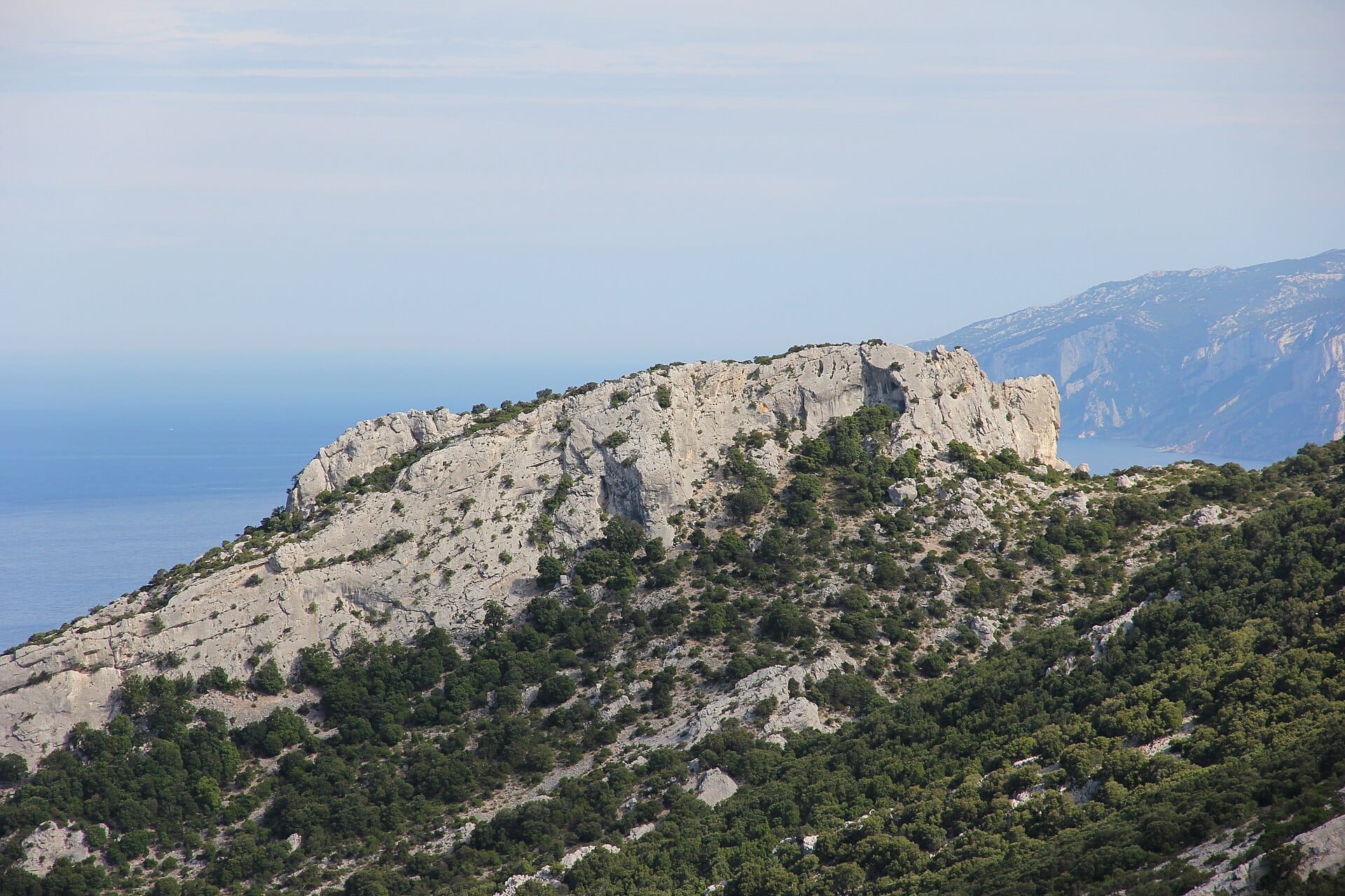
The Parco Nazionale del Golfo di Orosei e del Gennargentu was established in 1998 and covers approximately 739 square kilometres of central-eastern Sardinia. On paper it would be the island's largest national park, and one of the most topographically extreme in Italy, although the park has never become fully operational as an institution. The territory takes in the Gennargentu massif, including Punta La Marmora at 1,834 metres, Sardinia's highest point, as well as the dramatic limestone coast of the Golfo di Orosei to the east, where vertical cliffs fall directly into water of improbable clarity.
The designated park area spans 24 municipalities across three traditional subregions: Barbagie, Mandrolisai, and Ogliastra. These are not tourist-facing names but administrative and cultural realities, each with distinct landscape character. The Barbagia interior is dense with holm oak forest and grazing land; the Ogliastra flank drops sharply toward the sea through limestone plateaus cut by deep gorges. There is no single entrance gate, no visitor centre you must pass through, and no ticket booth. The park is a protected zone overlaid on a working landscape, meaning you will encounter shepherds, agricultural roads, and small villages alongside designated trails.
ℹ️ Good to know
Admission to the park is free. However, reaching many of its most-visited features, particularly the beaches along the Golfo di Orosei, requires hiring a boat from Cala Gonone or Santa Maria Navarrese, which involves separate costs. Budget accordingly.
The Mountain Interior: Gennargentu in Practice
The Gennargentu range does not look like the Dolomites or the Alps. The peaks are rounded and wind-scoured, often emerging from treeline into open grassland grazed by the Sarda sheep breed. In the early morning, particularly between October and April, the upper slopes are frequently swathed in low cloud that burns off by mid-morning to reveal wide views across the island's central plateau. Summer mornings are the clearest, though afternoon thunderstorms can form quickly above 1,500 metres between June and September.
Punta La Marmora, at 1,834 metres, is the logical goal for anyone wanting to stand on the roof of Sardinia. The ascent from the Funtana Cungiada area near Fonni is a moderate, mostly unmarked hike across open ridgeline. The summit itself is not dramatic in the alpine sense; there is no sheer face, just a broad rocky top with a metal trig point and views extending on clear days to both coasts. The emotional payoff comes from the scale of the landscape below rather than the summit itself.
For those who want more defined trail infrastructure, the Gola di Su Gorropu gorge on the park's northeastern margin is one of Europe's deepest canyons and can be reached on foot from the Flumineddu valley. The walls reach up to 500 metres in height and the canyon floor is choked with enormous boulders. It is accessible without technical climbing in the dry season, though the final section requires scrambling over those boulders, which can be ankle-breaking work in unsuitable footwear.
Tickets & tours
Hand-picked options from our booking partner. Prices are indicative; availability and final rates are confirmed when you complete your booking.
Vineyard Guided Tour and 7 Wine Tasting in Palau
From 84 €Instant confirmationFree cancellationFull-Day Sailboat Tour in La Maddalena Archipelago from Cannigione
From 112 €Instant confirmationFree cancellationHiking excursion to the Devil's Saddle
From 35 €Instant confirmationFree cancellationExcursion to the Archaeological site of Nora
From 70 €Instant confirmationFree cancellation
The Coastal Zone: Golfo di Orosei
The eastern boundary of the park meets the Golfo di Orosei, a 40-kilometre arc of coastline where limestone plateaus called supramonte end at the sea in vertical cliff faces. There are no coastal roads here. The beaches, including Cala Luna, Cala Mariolu, and Cala Goloritzè, are accessible only by boat from Cala Gonone or on multi-day hiking routes. This inaccessibility is precisely what has kept them in the condition they are in.
Cala Goloritzè, reachable via a steep 90-minute trail from the Baunei plateau or by sea, is arguably the most architecturally striking beach on the island: a small white-pebble cove framed by a natural stone arch and a pinnacle rising from the water. It was declared a natural monument in 1993. The trail down from the plateau offers increasingly dramatic views of the coast and is manageable for fit walkers in good conditions. See our full guide on Cala Goloritzè for trail details and seasonal conditions.
In the peak summer months, boat departures from Cala Gonone begin early in the morning, often around 9am, and the most popular beaches are crowded by late morning. Arriving by trail, which requires an early start from the plateau, usually means reaching the coast before the boats arrive. The difference in atmosphere between 8am and 11am at these beaches is significant.
⚠️ What to skip
The Selvaggio Blu, a multi‑day coastal trekking route (often planned over about 6–7 days) running along the Golfo di Orosei cliffs, is considered one of the most technically demanding long-distance routes in Europe. Do not attempt it without a local guide, precise topographic maps, and abseil experience. It is not a trail for general trekkers.
Wildlife, Flora, and What You Might Actually See
The park is home to the Sardinian deer (cervo sardo), a subspecies endemic to the island and noticeably smaller than its mainland European relatives. It is most often spotted at dusk along the forested margins of valleys in the Barbagia zone. The park also supports populations of mouflon, the wild sheep with curved horns that is closely associated with Sardinian highland imagery, as well as wild boar. Golden eagles nest in the limestone cliff faces of the supramonte.
At sea level, the protected waters of the Golfo di Orosei hold Posidonia oceanica meadows, an important indicator of water quality, and the submerged caves along the coast attract divers for their formations and fish life. Bottlenose dolphins are regularly seen in the gulf. The monk seal, once present, is no longer reliably sighted in these waters.
The plant communities shift with altitude. The coastal supramonte carries macchia scrub and juniper down to the cliff edges. At mid-altitude, dense holm oak forest covers much of the Barbagia hills. Above 1,400 metres, the trees give way to grassland and low-growing rockrose. Spring, roughly March to May, brings wildflower blooms that cover lower slopes in colour, and this is when the landscape is at its most photogenic.
How to Plan Your Time
The park has no single logical starting point. Travellers approaching from the north typically base themselves in Dorgali or Cala Gonone for coastal access. Those focused on the mountain interior are better placed in Fonni or Aritzo. The Ogliastra villages of Baunei, Triei, and Tortolì serve the southern coastal trails. A car is not optional here: public transport does not penetrate the park's interior. If you are building a wider itinerary through this region, our Sardinia road trip guide covers practical routing through central-eastern Sardinia.
The best overall period for a visit is May to June or September to October. July and August bring reliable weather but also significant crowds at the coastal sites, intense heat on exposed mountain trails (temperatures can exceed 35°C at altitude), and a higher fire risk in the interior. In September the light softens, crowds thin, and the sea remains warm enough for swimming. For a broader picture of how weather affects planning across the island, see the best time to visit Sardinia guide.
Winter in the Gennargentu is cold by Sardinian standards: snowfall above 1,000 metres is common between December and February, and some mountain roads become impassable. The coastal zone remains mild and walkable in winter, with the added benefit of complete solitude. The sea is cold for swimming, but the light and the emptiness make it a legitimate off-season destination for hikers.
💡 Local tip
If you want to combine mountain and coastal hiking in a single trip, base yourself in the Dorgali area. It sits at the convergence of Su Gorropu access, Cala Gonone boat departures, and routes toward the Gennargentu ridge, all within 30-40 minutes by car.
Practical Considerations
Trails in the park vary considerably in marking quality. Some routes, particularly in the supramonte, are faint or unmarked and require navigational competence with a topographic map or GPS track. The CAI (Club Alpino Italiano) maintains some marked routes, but do not assume trail signage to be reliable throughout. Inform someone of your planned route before heading into the interior.
Water sources in the mountain interior can be found at springs, but these should be treated or filtered before drinking. The coastal zone has no fresh water accessible to day visitors. Carry more water than you think you need, particularly in warm months: 2-3 litres per person per day is a minimum for exposed summer hiking.
Mobile phone coverage is patchy to non-existent in gorges and on remote ridgelines. The 112 emergency number covers Italy including Sardinia, but rescue services may take considerable time to reach deep terrain. Several local outfitters in Cala Gonone, Dorgali, and Baunei offer guided hikes and climbing excursions into the park, which substantially reduces the logistical and safety burden. If you are planning longer routes such as the Selvaggio Blu or multi-day coastal traverses, using a licensed local guide is a practical necessity rather than an optional extra.
Wheelchair access and pushchair suitability are extremely limited within the park. The terrain is rugged throughout, and even the gentler forest tracks near trailheads involve uneven surfaces. Visitors with limited mobility are better served by scenic drives to viewpoints on the plateau roads above Baunei or by boat excursions along the coast, which give access to the visual drama of the landscape without technical trail walking.
Insider Tips
- The plateau road above Baunei toward the Golgo plain is driveable by standard car and provides an extraordinary view over the coastal supramonte without any hiking. The abandoned church of San Pietro di Golgo sits in a clearing at the edge of a large sinkhole and is worth the short detour.
- Boat excursions from Cala Gonone to the gulf beaches fill up fast in July and August. Book the morning departure at least a day ahead from the harbour cooperative, and arrive at the dock 20 minutes early. The last boats back typically depart in the late afternoon (often around 5pm), and missing these can mean a very long and uncomfortable wait on the coast until services resume.
- If you are hiking in the Gennargentu interior, the roads between Fonni and Desulo offer some of the most dramatic highland driving on the island, with layered views across the massif. This is also genuine Barbagia: the villages along this route are working communities, not tourist destinations, and the local bars serve proper espresso and nothing else.
- Spring wildflowers on the lower slopes, particularly in April and May, are significant enough to plan around. The coastal macchia blooms with rockrose and asphodel, and the contrast with the blue water below is at its most photogenic in morning light.
- The Grotta del Bue Marino, a sea cave accessible by boat from Cala Gonone, sits within the park's coastal zone. It connects to a broader network of caves and is one of the few places in Sardinia where the cave and coastal landscape can be experienced in a single short excursion.
Who Is Parco Nazionale del Golfo di Orosei e del Gennargentu For?
- Committed hikers who want serious mountain and canyon terrain, not just scenic walks
- Nature photographers, especially in spring for wildflowers and in autumn for light quality
- Travellers who have already seen the Costa Smeralda and want to understand a completely different side of Sardinia
- Sailors and sea kayakers exploring the Golfo di Orosei coastline
- Anyone with several days to spend and a hire car, who wants to combine mountain, gorge, and coastal environments in one base area
Nearby Attractions
Other things to see while in Ogliastra:
- Capo Comino Dunes & Beach
A 3-kilometre stretch of white sand and wind-sculpted dunes on Sardinia's eastern coast, near Siniscola. The shallow sea, open access, and historic shipwrecks offshore make it one of the Nuoro province's most distinctive beaches.
- Grotte Su Marmuri (Ulassai)
Grotte Su Marmuri is a vast living limestone cave carved into the rocky highlands above the village of Ulassai in Ogliastra, eastern Sardinia. With chambers reaching up to around 50 metres high, active stalactite formations, and a constant interior temperature of 10°C, it offers one of the most impressive underground experiences on the island. Entry is by guided tour only, lasting approximately 1.5 hours.
- Punta La Marmora
At 1,834 metres, Punta La Marmora is the highest point in Sardinia and the crown of the Gennargentu massif. The hike rewards those who make the effort with panoramic views across the island's rugged interior, a genuine sense of remoteness, and a perspective on Sardinia that most visitors never see.
- Rocce Rosse di Arbatax
The Rocce Rosse di Arbatax are a formation of deep vermillion porphyry cliffs rising up to about 15 metres from the Tyrrhenian Sea on Sardinia's Ogliastra coast. Free to visit year-round, they sit steps from the port and the Trenino Verde station, making them one of the more accessible natural landmarks on the island's eastern shore.