Selvaggio Blu: The Wild Blue Trek Along the Gulf of Orosei
The Selvaggio Blu is one of Italy's most demanding long-distance routes, threading 40 kilometres of limestone cliffs, sea caves, and remote coves along Sardinia's east coast. Expect abseiling, route-finding, wild camping, and zero mobile signal. It rewards experienced trekkers with scenery that is simply not accessible any other way.
Quick Facts
- Location
- Municipality of Baunei, Gulf of Orosei, east Sardinia
- Getting There
- Drive to Santa Maria Navarrese or Pedra Longa; boat transfers to Cala Sisine arranged via local operators
- Time Needed
- 4 to 7 days for the full route (approx. 40 km)
- Cost
- No admission fee; guided packages from approx. €1,099 per person for 5-day programmes
- Best for
- Experienced trekkers and climbers with multi-day backcountry experience
What the Selvaggio Blu Actually Is
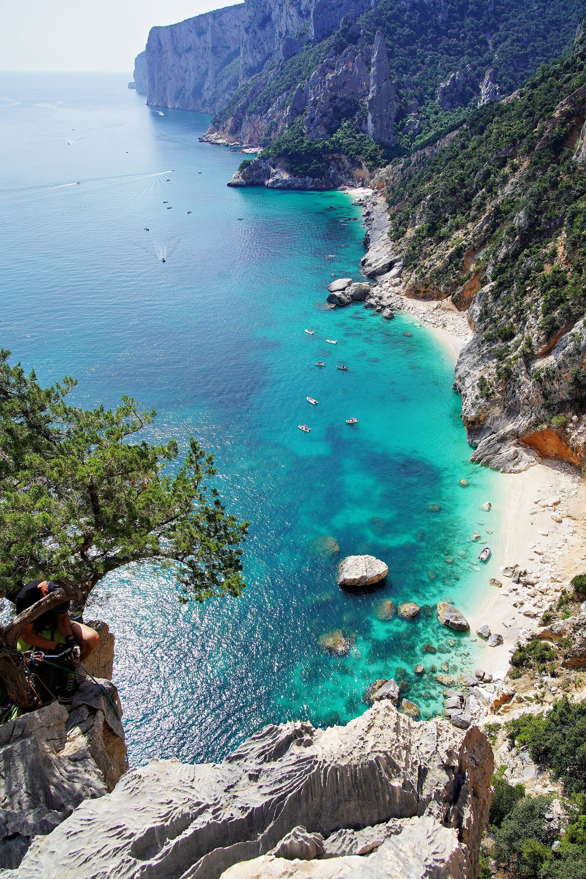
The Selvaggio Blu (Italian for 'Wild Blue') is a point-to-point wilderness route running roughly 40 kilometres along the limestone sea-cliffs of the Gulf of Orosei, entirely within the municipality of Baunei in eastern Sardinia. It is not a marked trail in the conventional sense. There are no mountain huts, no rescue stations along the route, and in most sections no reliable phone signal. The terrain demands scrambling on exposed limestone, abseiling down cliff faces to access beaches, and route-finding through dense Mediterranean maquis where the path disappears entirely.
The route was conceived in the late 1980s by photographer and alpinist Mario Verin together with architect Peppino Cicalò, who was then president of the Nuoro section of the Italian Alpine Club (Club Alpino Italiano). Their aim was to link the most spectacular and inaccessible sections of the Orosei coastline into a single continuous traverse, using the skills of alpinism rather than simply walking. That original spirit still defines the experience today.
The classic itinerary runs from south to north, starting near Pedra Longa and finishing at Cala Sisine beach. Some parties reverse this direction, and variants exist that adjust total distance to between 35 and 45 km. Either way, the commitment level is the same: once you are on the route, there are very few points where rescue or evacuation is straightforward.
⚠️ What to skip
The Selvaggio Blu is not a demanding hike that requires good fitness. It is a technical mountaineering route that requires abseiling experience, rope handling, and confident scrambling on exposed terrain. Serious accidents have occurred here. If you have never used a harness and descender, do not attempt this independently.
The Terrain: What You Are Walking Into
The dominant material underfoot for most of the route is pale grey Jurassic limestone, eroded into sharp fins, pockmarked ledges, and slick polished faces. In the early morning, before the sun reaches the cliff tops, the rock is cold to the touch and the surface is covered in dew, making even moderate scrambles feel precarious. By midday in May or September, the same rock radiates stored heat back at you from below.
Vegetation alternates between open clifftop sections with panoramic views across the Tyrrhenian Sea and claustrophobic tunnels through dense juniper, cistus, and wild rosemary scrub. The smell of sun-warmed rosemary and hot limestone is the olfactory signature of the Selvaggio Blu. Goat bells sometimes ring from invisible hillsides. The silence between those bells is complete.
The coastline you are traversing forms part of the broader Gulf of Orosei, which is one of the most geologically significant stretches of the Italian Mediterranean coast. The cliffs drop vertically into water of a colour that defies easy description: somewhere between cobalt, turquoise, and the specific green-blue of a shallow lagoon over white sand. The depth of colour intensifies towards midday and fades again by late afternoon.
Tickets & tours
Hand-picked options from our booking partner. Prices are indicative; availability and final rates are confirmed when you complete your booking.
Vineyard Guided Tour and 7 Wine Tasting in Palau
From 84 €Instant confirmationFree cancellationFull-Day Sailboat Tour in La Maddalena Archipelago from Cannigione
From 112 €Instant confirmationFree cancellationHiking excursion to the Devil's Saddle
From 35 €Instant confirmationFree cancellationExcursion to the Archaeological site of Nora
From 70 €Instant confirmationFree cancellation
The Route Day by Day
Most parties complete the Selvaggio Blu in five to seven days, bivouacking on rock ledges or sandy cove beaches where space allows. There are no designated campsites on the route itself. Water sources are scarce and unreliable; carrying two to three litres per person at all times is standard practice, with resupply possible at certain coastal springs that experienced guides know.
The abseils are the defining technical elements. Several descents require ropes of 30 to 50 metres to reach beaches or traverse cliff sections. Fixed anchors exist at some of the classic abseil points, but their condition should never be assumed to be reliable: always carry your own anchor-building equipment and check every piece of fixed gear before weighting it.
Alongside the route lie several of the most spectacular beaches on the Sardinian coast, accessible to boats but otherwise cut off from road access. Cala Goloritzé, a protected natural monument, is visible during the traverse. Cala Mariolu and Cala Sisine are among the overnight stopping points near the northern end of the route. In high summer these same beaches draw hundreds of day-trippers arriving by boat from Cala Gonone, so the contrast between their experience and yours is stark: you will have walked there from five days away.
When to Go and How the Season Changes Everything
April, May, September, and October are the recommended months. In spring, wildflowers cover the clifftop scrub and the sea temperature is still cool enough that swimming after a long afternoon of scrambling feels restorative rather than just refreshing. The days are long enough to allow comfortable daily distances of 6 to 10 km without the brutal heat of summer.
June is possible but the heat on south-facing cliff sections is already serious. July and August should be avoided: temperatures on exposed limestone can exceed 38°C and carry intense sun radiation reflected off pale rock and sea. More critically, the combination of heat and physical exertion at altitude creates a medical risk that should not be underestimated in an environment where helicopter rescue is the only realistic emergency option.
Winter months bring rain and unstable conditions to the Orosei coast. Wet limestone is dangerous on scrambling and abseil sections. November through March is not recommended for this route.
💡 Local tip
Early September is arguably the ideal window: the sea temperature peaks (often above 24°C), wildfire risk has decreased, crowds on the coastal beaches are falling, and the light in the late afternoon gives the limestone cliffs an orange-gold tone that photographers specifically target.
Guided vs Independent: What to Know
Independent completion of the Selvaggio Blu requires a specific combination of skills: confident multi-pitch abseiling, off-trail navigation with map and compass (GPS is useful but batteries die), experience with bivouacking in exposed locations, and the judgment to turn back if conditions change. Missing any one of these is a serious risk, not an inconvenience.
Guided operators based in the Baunei and Cala Gonone area offer structured programmes, typically five to seven days, covering all technical rope work, route-finding, water logistics, and often boat transfers to the start or end points. Prices for commercial guided programmes are in the range of approximately €1,099 per person for a five-day trip, based on published rates from operators such as Sardinia Trekking. This is not a cheap option, but the logistical complexity of the route, the equipment required, and the genuine technical knowledge of experienced local guides makes it substantially less expensive than the alternative, which is a mountain rescue operation.
If you are considering the route independently, the most useful preparation is to first complete a day-hike along accessible sections of the Gulf of Orosei coastline, for example around Cala Gonone, to understand the nature of the terrain before committing to the full traverse.
Getting to the Trailheads
The southern trailhead at Pedra Longa is reached by driving the SS125 Orientale Sarda highway to the village of Santa Maria Navarrese, then following the narrow coastal road south to the distinctive monolith of Pedra Longa, a limestone pinnacle of about 128 metres that rises directly from the sea. There is roadside parking at a small bar near the base of the rock.
The northern trailhead at Cala Sisine has no direct paved road access to the beach itself, which is precisely why the cove looks the way it does. It is reached by boat from Cala Gonone, arranged through local operators who run regular summer services. If you are walking south to north, your exit strategy depends entirely on pre-arranging this boat transfer. Miss the last boat and you are spending another night on the coast.
For travellers flying into Sardinia, the nearest practical gateway by main road is via the SS125 from Cagliari (approximately 2 to 3 hours by car) or from Nuoro (approximately 1.5 hours). There is no direct public transport to the Pedra Longa trailhead. A rental car is essential for independent travellers. For more on getting around eastern Sardinia, see the guide to getting around Sardinia.
Who Should Not Do This Route
The Selvaggio Blu is not for people who want challenging walking in dramatic scenery. That description fits dozens of other trails in Sardinia, including sections of the Gennargentu range and the Supramonte plateau. This route is for people who specifically need the technical and physical challenge of the full traverse, and who have the skills to manage what they find.
Travellers who want to experience the Gulf of Orosei coastline without the technical commitment have excellent alternatives. The sea-level approach to Cala Luna is one of the most beautiful short hikes in Sardinia, and the boat trips from Cala Gonone to Cala Goloritzé offer the visual reward of this coastline without the rope work. See the Sardinia boat trips guide for full details on coastal boat excursions.
People with a fear of heights, anyone with knee or joint issues that affect descending on uneven terrain, casual hikers, families with children, and anyone who has not carried a multi-day pack on technical terrain should approach this with complete honesty about their experience level. The remoteness is real, not scenic language.
Insider Tips
- The abseil anchors at key descent points are inspected and maintained by local guides each season, but you should carry a small rack of slings and screwgate carabiners to back up or replace any anchor you are not fully confident in. Never trust fixed tat you have not personally assessed.
- Most guided groups leave Pedra Longa very early in the morning, around 6am, to gain altitude before the midday heat. The quality of light on the cliffs at dawn, combined with complete silence before the wind picks up, makes this the best photography window of the entire trip.
- Water is the critical logistical variable. Experienced guides know the locations of seasonal springs along the route, but these can fail in dry years. If you are going independently, contact local guides in Baunei before departure and ask specifically about current water source conditions.
- Pack weight is the most common mistake first-timers make. Every gram you carry is a gram you carry up and down cliff sections. Aim for a pack under 12 kg including water, ropes, and camping gear. If you cannot get below that weight, reconsider what you are bringing.
- The Comune di Baunei maintains a local office that can provide current information on route conditions and recommend registered guides. Contact them in advance of your trip, particularly if you are planning an independent traverse.
Who Is Selvaggio Blu Trekking Route For?
- Experienced multi-day trekkers and alpinists with abseiling and scrambling skills
- Photographers targeting Sardinia's most remote coastal light and landscapes
- Adventure travellers who want an objective challenge rather than a scenic walk
- Small guided groups looking for a technically demanding itinerary in a warm Mediterranean environment
- Travellers who have already explored Sardinia's accessible coastline and want to go further
Nearby Attractions
Other things to see while in Golfo di Orosei:
- Cala Goloritzè
Cala Goloritzè is a protected natural monument on Sardinia's eastern coast, where a limestone pinnacle of about 143–148 metres towers over a pebble beach and crystalline water. Accessible only by a moderately strenuous hike or by sea, it rewards the effort with scenery that few coves in the Mediterranean can match.
- Cala Gonone
Cala Gonone is a small seaside town tucked beneath limestone cliffs on Sardinia's eastern coast, serving as the main launch point for the Golfo di Orosei's famous sea caves, secluded coves, and dramatic hiking routes. Whether you arrive by boat, bus, or car, this is where the real adventure begins.
- Cala Luna
Cala Luna is an 800-metre crescent of pale pink-tinged sand framed by limestone cliffs that rise up to 300 metres above the waterline. Straddling the municipal boundary between Baunei and Dorgali in the Gulf of Orosei, it has no road access and only minimal seasonal beach infrastructure — which is precisely why it looks the way it does.
- Cala Mariolu
Tucked beneath the limestone cliffs of Costa di Baunei, Cala Mariolu is one of the eastern Sardinian coast's most extraordinary beaches. Famous for its white pebble shore, improbably clear water, and sheer rock walls rising hundreds of metres, it demands effort to reach but rewards accordingly. This guide covers every access route, the new reservation system recently introduced to manage visitor numbers, and what first-time visitors consistently get wrong.