Cala Sisine: The Gulf of Orosei's Most Spectacular Beach
Cala Sisine sits at the mouth of the Codula di Sisine gorge on Sardinia's eastern coast, enclosed by limestone cliffs that rise up to around 500 metres. Reachable by boat or via a hike through a dry riverbed, it rewards the effort with one of the widest, least commercialised beaches on the entire Baunei coast.
Quick Facts
- Location
- Baunei municipality, Gulf of Orosei, eastern Sardinia
- Getting There
- By boat from Cala Gonone, Santa Maria Navarrese or Arbatax; or hike ~2 km from Planu 'e Murta (4×4 recommended to trailhead)
- Time Needed
- Half day minimum; full day recommended if hiking in
- Cost
- Beach access free; boat excursions and 4×4 transfers charged by operator (verify current prices directly)
- Best for
- Hikers, snorkellers, photographers, travellers who want a serious beach without the resort infrastructure
- Official website
- www.sardegnaturismo.it/en/explore/cala-sisine
What Is Cala Sisine?
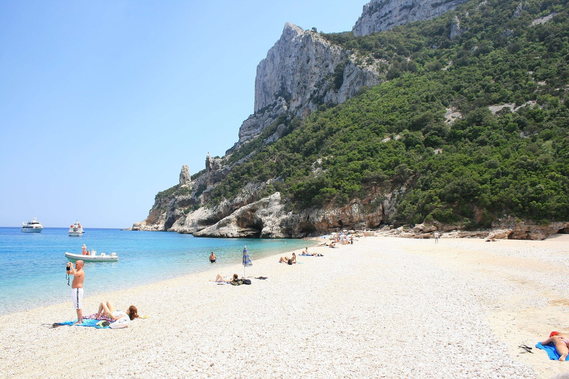
Cala Sisine is a large, undeveloped cove at the southern end of the Gulf of Orosei, on Sardinia's eastern coast within the municipality of Baunei. The beach stretches roughly 200 metres along the shoreline and sits around 100 metres deep, making it among the most spacious on the Baunei coast. What sets it apart from nearby coves is the sheer scale of its setting: the cliffs of Serra Ovra rise to around 500 metres on either side, turning the approach by sea into something theatrical.
The cove marks the end of the Codula di Sisine, a dry river gorge that cuts inland from the Golgo plateau. For centuries this natural inlet served as a loading point for charcoal transported down from the plateau, and old maps list it as Portu 'e Sisine. That working-harbour past is long gone. Today the main structure is the seasonal restaurant Su Coile or similar beach bar, generally operating in the summer season, plus a few wooden signs at the trail junction. There is no road access for standard vehicles, no parking area at the beach, and no ticket booth.
ℹ️ Good to know
Beach access is free. Costs apply only to transport: boat excursions from nearby ports, licensed 4×4 transfers to the trailhead at Planu 'e Murta, and guided hikes. Verify current prices directly with operators before booking, as they vary by season.
Getting There: Two Very Different Experiences
By Boat
Most visitors arrive by sea. Excursion boats depart seasonally from Cala Gonone to the north and from Santa Maria Navarrese to the south, with some operators also offering trips from Arbatax. The coastal approach along the Gulf of Orosei passes sheer limestone walls dropping straight into water that shifts from deep blue to transparent turquoise as the boat slows into the cove. From the water you see the full height of the cliffs before you step onto the beach, which gives a sense of arrival that few other beaches on the island can match.
Boats typically stop for two to three hours before returning, which is enough time to swim, snorkel, and eat at Su Coile but not enough to explore the gorge on foot. If you want both the coastal approach and time to walk the Codula di Sisine, plan an overnight stay elsewhere in the area, or consider combining a morning boat with a separate hiking day. For broader context on the Gulf of Orosei's coastal options, see the Cala Gonone guide, which covers departure points and tour operators in detail.
By Land: The Codula di Sisine Hike
The land approach starts on the Golgo plateau near Baunei. From the road about 200 metres before the Church of San Pietro, a dirt track branches right and runs across the Golgo plateau toward the Planu 'e Murta area. The track is passable by 4×4 and high-clearance off-road vehicles; standard cars are best left at Ololbissi, roughly 8 kilometres from the beach on foot. From Planu 'e Murta, a signposted trail descends a little over 1 kilometre through the Codula di Sisine gorge to the shore, taking approximately 30 minutes in each direction for most walkers.
The gorge trail follows the former riverbed. The terrain is uneven and rocky but without significant elevation changes, making it physically manageable for most walkers with appropriate footwear. What the walk delivers is a slow transition from open limestone plateau to enclosed canyon: the walls close in progressively, the light changes quality, and the sound of the sea eventually cuts through the silence of the rock. Wild figs and lentisk grow in the cracks; in spring the gorge floor has patches of flowering scrub.
⚠️ What to skip
The Codula di Sisine is a dry riverbed that can flood rapidly during heavy rain. Do not attempt the gorge hike if rain is forecast or if the sky over the plateau looks threatening. Always carry at least 1.5 litres of water per person; there is no reliable fresh water source on the trail.
Licensed 4×4 transfer services operate from Baunei town to the trailhead during the season, making the hike accessible to visitors without off-road vehicles. The hiking in Sardinia guide covers the broader context of Baunei coast trails, including the logistics of the Selvaggio Blu route that passes through this same gorge system.
Tickets & tours
Hand-picked options from our booking partner. Prices are indicative; availability and final rates are confirmed when you complete your booking.
Gulf of Orosei mini cruise from Cala Gonone
From 53 €Instant confirmationFree cancellationSpeedboat Trip to Gulf of Orosei with Aperitif from Cala Gonone
From 119 €Instant confirmationFree cancellationCala Goloritze and Cala Luna dinghy tour from Orosei
From 149 €Instant confirmationFree cancellationSnorkeling in the Gulf of Orosei from Cala Gonone
From 95 €Instant confirmationFree cancellation
The Beach Itself: What to Expect
The beach is made up of white and pale-grey pebbles mixed with coarse sand, firm enough underfoot but not the powdery soft surface you find at beaches further south. The water is exceptionally clear, ranging from light green close to shore to deep blue within a few metres. There are no sun lounger rentals, no umbrellas for hire, and no dedicated swimming zones. You bring what you need or you go without.
The cliffs give the cove a natural amphitheatre quality that affects how the beach feels at different hours. In the morning, when boats begin to arrive from Cala Gonone, the sun reaches the centre of the beach first while the cliff bases stay in shadow. By early afternoon the entire beach is in full sun and the temperature against the pale stone background is intense. By mid-afternoon, depending on the season, the western cliff begins to shade part of the beach again and the light on the water softens considerably.
The water is ideal for snorkelling directly off the shore. The cliff bases on both sides of the cove drop into deeper water quickly, and the rock formations below the surface are varied enough to hold a reasonable diversity of fish. You do not need a boat to reach good snorkelling; a short swim from the beach edge is sufficient.
Crowds and Timing: The Honest Picture
Cala Sisine's relative inaccessibility keeps it quieter than beaches reachable by road, but it is not unknown. In July and August, boat excursions arrive in overlapping waves through the middle of the day and the beach can become crowded between roughly 11:00 and 15:00. Hikers who arrive before 10:00 or after 15:30 will find the cove significantly calmer.
May, early June, and September offer the best balance of weather and manageable visitor numbers. The sea is warm enough for extended swimming from late May onward, and boat services are typically running. By late September the excursion boat frequency drops and the beach returns to a different rhythm. For a full breakdown of seasonal conditions across the island, the best time to visit Sardinia guide covers crowd patterns, sea temperatures, and weather month by month.
💡 Local tip
If you are arriving by boat and want a quieter experience, ask your operator which departure time arrives earliest at Cala Sisine. The first boats of the day leave the cove well before the mid-morning rush and you may have the beach largely to yourself for the first hour.
Historical and Ecological Context
The Codula di Sisine gorge that feeds into the beach is part of a larger karst landscape carved into the limestone of the Baunei coast over millions of years. The Golgo plateau above sits at roughly 400 to 500 metres elevation, and the valley system that drains it has created a series of deep coastal canyons. The Codula di Sisine is one of the longest of these, and the beach at its mouth is where the canyon meets the sea.
The name Portu 'e Sisine reflects centuries of practical use. Charcoal from the plateau forests was brought down by mule and loaded onto small boats in the natural shelter the cliffs provided. The area around Baunei has a long history of agro-pastoral land use, and the plateau above the beach holds the remains of nuragic structures and other archaeological sites that speak to continuous human presence in this landscape going back several thousand years. For more on Sardinia's nuragic heritage, the guide to Sardinia's Nuragic sites provides a thorough overview.
The cliffs and gorge are within the territory associated with the Gulf of Orosei and Gennargentu protected area system. The vegetation in the gorge, primarily Mediterranean maquis including wild rosemary, lentisk, myrtle and dwarf palms, is typical of the eastern Sardinian coastal interior. Peregrine falcons are known to nest on the cliff faces above the cove, and the area is a recognised habitat for several bird species that use the cliff ledges for shelter.
Practical Information for Your Visit
There are no formal opening hours at Cala Sisine. Access to the beach is unrestricted, but boat services and 4×4 transfers are seasonal, operating primarily from spring through early autumn. If you plan to hike in independently, confirm road conditions on the Golgo plateau before setting out, particularly early and late in the season.
The restaurant Su Coile near the beach typically operates from April to October, offering food and drinks. Outside that window, there are no facilities at all. Carry enough water for the return hike even if you plan to eat at the restaurant, as conditions and opening days can vary.
- Footwear: closed-toe hiking shoes or trail runners for the gorge hike; sandals are inadequate on the rocky trail
- Water: minimum 1.5 litres per person for the hike; more in July and August
- Sun protection: the beach offers very little natural shade; a hat and reef-safe sunscreen are practical necessities
- Snorkelling gear: worth bringing your own mask and fins if you have them, as there is no rental service on the beach
- Cash: operators and the beach restaurant may not accept cards; bring euros
- Plastic bags: carry out all waste; there are no rubbish collection facilities at the beach
Cala Sisine is not wheelchair accessible and is not suitable for visitors with significant mobility impairments. The gorge trail involves uneven rocky terrain, and the boat approach requires stepping from a vessel onto the pebble beach. There is no adapted infrastructure of any kind at the site.
Photography
The best photographic light at Cala Sisine is in the early morning, before the beach fills with boat visitors and while the cliff faces are catching the low sun from the east. The coastal approach by boat is an excellent opportunity for wide-angle shots of the cliff system before you land. From the beach, the view back toward the gorge entrance, framed by the canyon walls, works well in the hour before midday when the interior of the gorge is lit from above rather than in shadow.
Underwater photography with a waterproof camera or housing is worthwhile at the cliff bases on either side of the cove. The water clarity in good conditions is exceptional, and the depth profile at the cliff edges creates interesting light gradients.
Insider Tips
- Book the earliest available boat departure from Cala Gonone or Santa Maria Navarrese. The first boats arrive at Cala Sisine before the mid-morning crowd and you get the beach, the light, and the quiet simultaneously.
- If you hike in, consider doing the descent in the morning and arranging a boat pickup to return. Several operators offer one-way coastal transfers in season, which saves the uphill return through the gorge in afternoon heat.
- The cliff base on the northern side of the cove, reached by a short swim from the beach, has deeper water and more varied rock formations for snorkelling than the shallower central area.
- Su Coile restaurant is a genuine local operation, not a tourist bar. The menu is limited but the food is freshly made. Arrive before 13:00 if you want a table, as boat visitors tend to converge at lunchtime.
- The gorge itself, not just the beach, is worth exploring. After the main boat visitors depart in the early afternoon, walking a few hundred metres back up the Codula di Sisine gives you extraordinary canyon silence and light that most day-trippers never see.
Who Is Cala Sisine For?
- Hikers and trekkers who want a purposeful approach to a beach rather than a car park and a sunbed
- Snorkellers looking for clear water and interesting cliff-base terrain without boat-based snorkelling tours
- Photographers wanting dramatic coastal light, cliff scale, and gorge landscape in a single location
- Travellers visiting in shoulder season (May, early June, September) who want a large, uncrowded beach with full natural setting
- Anyone combining a Golfo di Orosei coastal trip with inland Baunei plateau exploration
Nearby Attractions
Other things to see while in Golfo di Orosei:
- Cala Goloritzè
Cala Goloritzè is a protected natural monument on Sardinia's eastern coast, where a limestone pinnacle of about 143–148 metres towers over a pebble beach and crystalline water. Accessible only by a moderately strenuous hike or by sea, it rewards the effort with scenery that few coves in the Mediterranean can match.
- Cala Gonone
Cala Gonone is a small seaside town tucked beneath limestone cliffs on Sardinia's eastern coast, serving as the main launch point for the Golfo di Orosei's famous sea caves, secluded coves, and dramatic hiking routes. Whether you arrive by boat, bus, or car, this is where the real adventure begins.
- Cala Luna
Cala Luna is an 800-metre crescent of pale pink-tinged sand framed by limestone cliffs that rise up to 300 metres above the waterline. Straddling the municipal boundary between Baunei and Dorgali in the Gulf of Orosei, it has no road access and only minimal seasonal beach infrastructure — which is precisely why it looks the way it does.
- Cala Mariolu
Tucked beneath the limestone cliffs of Costa di Baunei, Cala Mariolu is one of the eastern Sardinian coast's most extraordinary beaches. Famous for its white pebble shore, improbably clear water, and sheer rock walls rising hundreds of metres, it demands effort to reach but rewards accordingly. This guide covers every access route, the new reservation system recently introduced to manage visitor numbers, and what first-time visitors consistently get wrong.