Cala Mariolu: The Gulf of Orosei's Most Breathtaking Cove
Tucked beneath the limestone cliffs of Costa di Baunei, Cala Mariolu is one of the eastern Sardinian coast's most extraordinary beaches. Famous for its white pebble shore, improbably clear water, and sheer rock walls rising hundreds of metres, it demands effort to reach but rewards accordingly. This guide covers every access route, the new reservation system recently introduced to manage visitor numbers, and what first-time visitors consistently get wrong.
Quick Facts
- Location
- Costa di Baunei, Gulf of Orosei, Municipality of Baunei, eastern Sardinia
- Getting There
- Cala Gonone (boat departures); Santa Maria Navarrese also popular for access
- Time Needed
- Half day minimum; most visitors arrive by boat and spend 2–4 hours at the cove
- Cost
- No beach entrance fee, but an environmental contribution may be charged locally and boat transport costs vary by operator
- Best for
- Swimmers, snorkellers, coastal hikers, photographers, and anyone chasing exceptional water clarity
- Official website
- www.calamariolu.it/en
What Cala Mariolu Actually Is
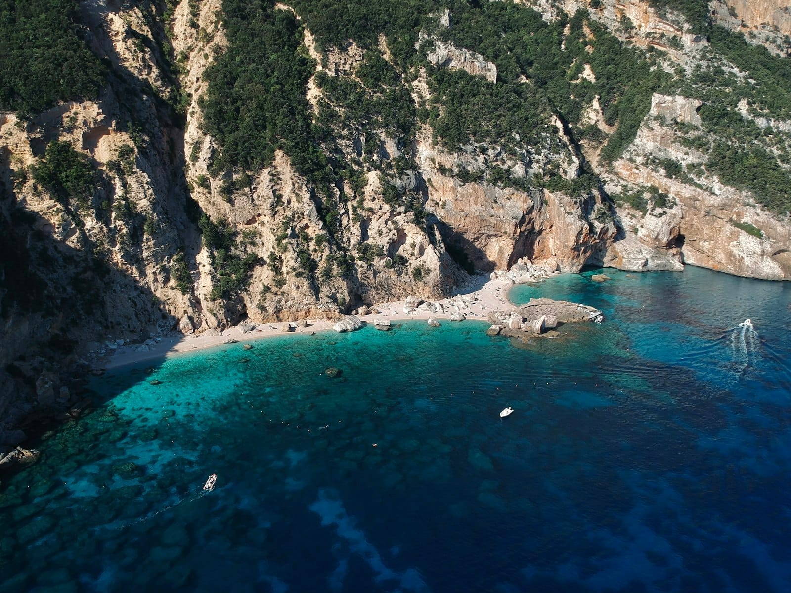
Cala Mariolu is a sheltered sea cove on the Costa di Baunei, carved into one of the most dramatic stretches of the Gulf of Orosei coastline in central-eastern Sardinia. The walls above it are limestone cliffs rising several hundred metres, so sheer and pale that they reflect light onto the water below, making the sea appear to glow from within. The shore itself is a mix of fine sand and small white pebbles — so white and rounded that in the local Baunese dialect the cove was originally called Ispuligedenie, meaning 'snow fleas.' That name describes the tiny white stones precisely.
In 2024, the international ranking The World's 50 Best Beaches listed Cala Mariolu as the best beach in Europe and second best in the world. That recognition brought a surge of international attention, but the cove's reputation among Italian and Sardinian travellers long predated any award. What makes it stand apart from other Gulf of Orosei beaches is the combination of scale, isolation, and water colour: a sequence of turquoise, teal, and deep blue shifting with depth and time of day, framed by cliff faces with no development visible in any direction.
ℹ️ Good to know
Local authorities have introduced visitor‑management measures for Cala Mariolu, which can include limits on daily numbers and regulated landings; check the official Baunei or Sardinia tourism channels for current rules before your trip, as requirements and booking procedures may change.
Getting There: Your Two Options
By Boat (The Standard Route)
The overwhelming majority of visitors arrive by sea. Boat excursions and shuttle services depart seasonally from Cala Gonone, Santa Maria Navarrese and Arbatax, typically running from late spring through early autumn. Cala Gonone tends to be the most popular departure point, partly because it sits within easy driving distance and has a well-organised harbour with multiple operators. Most group excursions stop at Cala Mariolu along a circuit of Gulf of Orosei coves, though dedicated single-destination options exist.
Those arriving by private or rented boat are subject to the same 2025 landing reservation system as group excursions. The QR code requirement applies regardless of how you arrive by water, so check the booking platform before departing. Disembarkation is directly onto the pebble beach — there is no jetty or pier. For passengers with mobility difficulties, this is worth considering carefully, as the landing involves stepping off a boat onto an uneven stony shore.
For more on organising sea-based trips along this coastline, the Cala Gonone guide covers boat operators, departure logistics, and what to expect from a full day on the Gulf of Orosei water.
On Foot: The Cliff-Top Trek
A hiking trail descends to Cala Mariolu from the Golgo Plateau, accessed from the Piredda area near Baunei. The route covers approximately 6 kilometres each way, with around 100–200 metres of ascent and a considerably more demanding 560–600 metres of descent — which means the climb back out is physically taxing, especially in summer heat. Official sources classify this as EE (Escursionismo Esperto, intended for experienced hikers), and the designation is accurate. Expect around 2 hours 30 minutes to 2 hours 45 minutes to descend; allow extra time for the return.
The trail is not a casual beach walk. The terrain is rocky and unshaded for much of its length, and the descent into the cove involves scrambling through sections that require sure footing. Proper walking footwear, plenty of water, and sun protection are non-negotiable. If you are hiking in, start early — by mid-morning the sun is intense, and returning up 560 metres of exposed trail at midday in July is difficult. The reward is that you experience a side of the coastline that boat passengers never see: the interior of the Gennargentu foothills, the silence of the plateau, and the first glimpse of the cove appearing far below between the cliffs.
⚠️ What to skip
Hikers arriving on foot are subject to the same general visitor‑management and environmental‑protection rules that apply to all access routes. Check current access regulations before your trip, as the rules for land arrivals may be updated. The trail is not suitable for children or anyone unfamiliar with rough mountain paths.
Tickets & tours
Hand-picked options from our booking partner. Prices are indicative; availability and final rates are confirmed when you complete your booking.
Full-day trekking experience to Cala Mariolu in Baunei
From 54 €Instant confirmationFree cancellationCala Goloritze, Mariolu, Gabbiani, Biriala, Grotta del Fico boat tour
From 69 €Instant confirmationFree cancellationGulf of Orosei mini cruise from Cala Gonone
From 53 €Instant confirmationFree cancellationSpeedboat Trip to Gulf of Orosei with Aperitif from Cala Gonone
From 119 €Instant confirmationFree cancellation
The Beach Itself: What to Expect
The cove is relatively compact, enclosed on three sides by limestone rock. The pebbles are smooth and predominantly white or pale grey — the Ispuligedenie of the dialect name — and they crunch softly underfoot. Water shoes or sandals with a good grip are strongly recommended, not just for the landing but for walking across the beach and entering the water. The pebble entry into the sea is uneven, and bare feet on a hot August day will remind you quickly why the locals suggest footwear.
The water is shallow for the first few metres before dropping away fairly quickly. Clarity is exceptional year-round, but early morning — before the first boats arrive — the surface is flat and the light angled low, turning the cove into something resembling a natural photography studio. By late morning, when boat traffic picks up, the water remains clear but the surface takes on more chop and the beach becomes progressively more crowded. Peak hours are roughly 10:30 to 14:00 in July and August. Those who can arrange an early morning arrival, whether on their own boat or with an operator willing to depart before 8 am, will find the experience qualitatively different from the midday rush.
Shade is limited and largely disappears as the sun climbs overhead. The cliffs offer patches of shadow in the early morning and late afternoon, but for several hours in the middle of the day the cove is fully exposed. There are no permanent facilities — no kiosks, no rental umbrellas, no toilets. What you bring is what you have. Factor this into how long you plan to stay.
Snorkelling and Swimming
Cala Mariolu is one of the better snorkelling locations on the Gulf of Orosei. The underwater rock formations continue the drama of the cliffs above the waterline, with boulders, overhangs, and narrow gullies harbouring sea urchins, fish, and occasional octopus. Visibility in calm conditions can exceed 20 metres, which makes even a basic mask and snorkel worthwhile.
Those interested in more structured underwater exploration of the Gulf of Orosei can read about the broader snorkelling and diving options in Sardinia, which covers the equipment rental situation at nearby bases and the best conditions by season.
Swimming is generally safe in calm weather, but the cove is open to swells from the south when winds build, and wave action on the pebble shore can become uncomfortable. If you are travelling with young children, check forecasts carefully. There are no lifeguards stationed at the beach.
When to Visit and Seasonal Considerations
The boat services that serve Cala Mariolu generally operate from late spring to early autumn, with peak frequency in the summer months. Outside these months, the cove is accessible only by foot, which in practice means very few people go at all. June and September represent the clearest trade-off between good conditions and manageable crowds. The water is fully swimmable by early June, and September retains summer warmth while the August peak passes. July and August deliver the best guaranteed weather but also the most pressure on the daily visitor cap — pre-booking the landing ticket as far ahead as possible is essential for those months.
The broader patterns of Sardinian seasonal travel are covered in the best time to visit Sardinia guide, which addresses how shoulder seasons affect the eastern coast specifically.
May can be beautiful — calm seas, low crowds, vivid spring light — but water temperatures are cooler, often around the high‑teens °C, which suits some swimmers and not others. The Mediterranean air temperature in May along this coast typically reaches the low‑20s °C during the day. In contrast, August often sees sea temperatures in the mid‑20s °C and daytime air temperatures that frequently exceed 30°C, with a constant parade of boats throughout the day. Both visits are valid; they are just different experiences.
Photography and Practical Logistics
The cove faces approximately south‑southwest, so direct sunlight becomes strongest from late morning into the afternoon rather than at first light. For photographers, this produces two distinct looks: soft, diffuse early-morning light that makes the water colour more saturated and even, and dramatic, angled afternoon light that creates contrast between the cliff shadows and the bright pebble shore. The most photographed perspective — looking back toward the cliff walls from the water — works well in the morning when the rock faces are evenly lit.
A waterproof housing or dry bag for camera equipment is sensible given the pebble landing from the boat. Drone use over the cove is subject to Italian aviation regulations and any local restrictions that may be in force under the visitor management system; do not assume aerial photography is permitted without checking current rules.
Cala Mariolu sits within one of Sardinia's most dramatic coastal stretches. If you are organising a broader trip to the area, the Sardinia boat trips guide explains how multi-cove excursions are typically structured and which departure points offer the best value and flexibility.
Who Will Not Enjoy This Beach
Cala Mariolu is not a beach for everyone. Visitors expecting a sandy shore, umbrella and sunbed rental, a beach bar, or easy flat-water entry will be disappointed. The pebble surface is unforgiving without footwear, there is zero shade infrastructure, and in peak season the cove fills quickly to its 700-person cap. Those with limited mobility will struggle both with the boat landing and with moving around on the uneven shore. Anyone who dislikes crowds in a small space should aim for early morning arrivals or visit in the shoulder months.
The hype around the 2024 award has also brought visitors who arrive expecting something effortless. The beauty is genuine and the water colour is remarkable, but the experience requires planning, reasonable physical fitness if hiking, or the logistical step of organising boat transport and advance reservations. Travellers looking for a more accessible but still spectacular Gulf of Orosei beach may find the nearby coves more straightforward.
For a broader look at the Golfo di Orosei's range of beaches and access options, the Golfo di Orosei destination guide covers the full spectrum from accessible town beaches to remote coves like Cala Sisine and Cala Luna.
Insider Tips
- Check current access rules and any required landing reservations as soon as you start planning — in peak season, boat excursions and permitted daily visitor numbers can sell out well in advance; use the official local tourism and operator channels for up‑to‑date booking details.
- If you are arriving by boat from Cala Gonone, ask operators specifically about departure times. Earlier boats (before 8:30 am) typically offer 30 to 45 minutes at the cove before the next wave of arrivals. That window is significantly more peaceful.
- Water shoes that stay on your feet securely are more useful than flip-flops here. The pebble gradient into the water is steeper than it looks from the boat, and you will want grip on the way back up.
- The cliff shadow covers the northern edge of the beach in the early morning. If you want shade without leaving early, position yourself under the rock wall on arrival rather than in the centre of the cove, where shade disappears by mid-morning.
- For hikers: fill water at the trailhead because there is nothing drinkable at the cove. The ascent back to the plateau is the harder half of the route — budget more energy for the return than the descent suggests you will need.
Who Is Cala Mariolu For?
- Swimmers and snorkellers seeking exceptional water clarity in a dramatic setting
- Photographers who want limestone cliff architecture and graduated turquoise sea in a single frame
- Experienced hikers willing to earn the view via the Golgo Plateau trail
- Travellers visiting in June or September who want a world-class beach without the peak August pressure
- Boat trip passengers combining a Gulf of Orosei coastal circuit with a proper stop at Sardinia's most celebrated cove
Nearby Attractions
Other things to see while in Golfo di Orosei:
- Cala Goloritzè
Cala Goloritzè is a protected natural monument on Sardinia's eastern coast, where a limestone pinnacle of about 143–148 metres towers over a pebble beach and crystalline water. Accessible only by a moderately strenuous hike or by sea, it rewards the effort with scenery that few coves in the Mediterranean can match.
- Cala Gonone
Cala Gonone is a small seaside town tucked beneath limestone cliffs on Sardinia's eastern coast, serving as the main launch point for the Golfo di Orosei's famous sea caves, secluded coves, and dramatic hiking routes. Whether you arrive by boat, bus, or car, this is where the real adventure begins.
- Cala Luna
Cala Luna is an 800-metre crescent of pale pink-tinged sand framed by limestone cliffs that rise up to 300 metres above the waterline. Straddling the municipal boundary between Baunei and Dorgali in the Gulf of Orosei, it has no road access and only minimal seasonal beach infrastructure — which is precisely why it looks the way it does.
- Grotte del Bue Marino
Carved into the limestone cliffs of the Gulf of Orosei, the Grotte del Bue Marino is a sea cave accessible only by boat, with a guided walk through roughly 1 km of stalactite chambers, underground lakes, and walls marked by Neolithic petroglyphs dating to around 4000 BC. It is one of the most distinctive geological and archaeological sites on Sardinia's eastern coast.