Pedra Longa: Sardinia's Most Dramatic Sea Stack
Rising 128 metres from the Tyrrhenian Sea on the wild Baunei coast, Pedra Longa is a freestanding limestone pinnacle that was declared a Natural Monument in 1993. Accessible by car or on foot from Santa Maria Navarrese, it marks the official starting point of the Selvaggio Blu, one of Italy's most demanding long-distance treks.
Quick Facts
- Location
- Baunei, Province of Nuoro, Golfo di Orosei, Sardinia
- Getting There
- By car via SS 125 (exit at km 153); on foot from Santa Maria Navarrese (~2 hrs)
- Time Needed
- 1–3 hours for the viewpoint and cove; half day if combining with a coastal walk
- Cost
- Free. No entrance fee. Parking is roadside with no listed tariff.
- Best for
- Geology enthusiasts, photographers, trekkers starting the Selvaggio Blu, and anyone driving the SS 125
- Official website
- www.turismobaunei.eu/en/services/pedra-longa
What Is Pedra Longa?
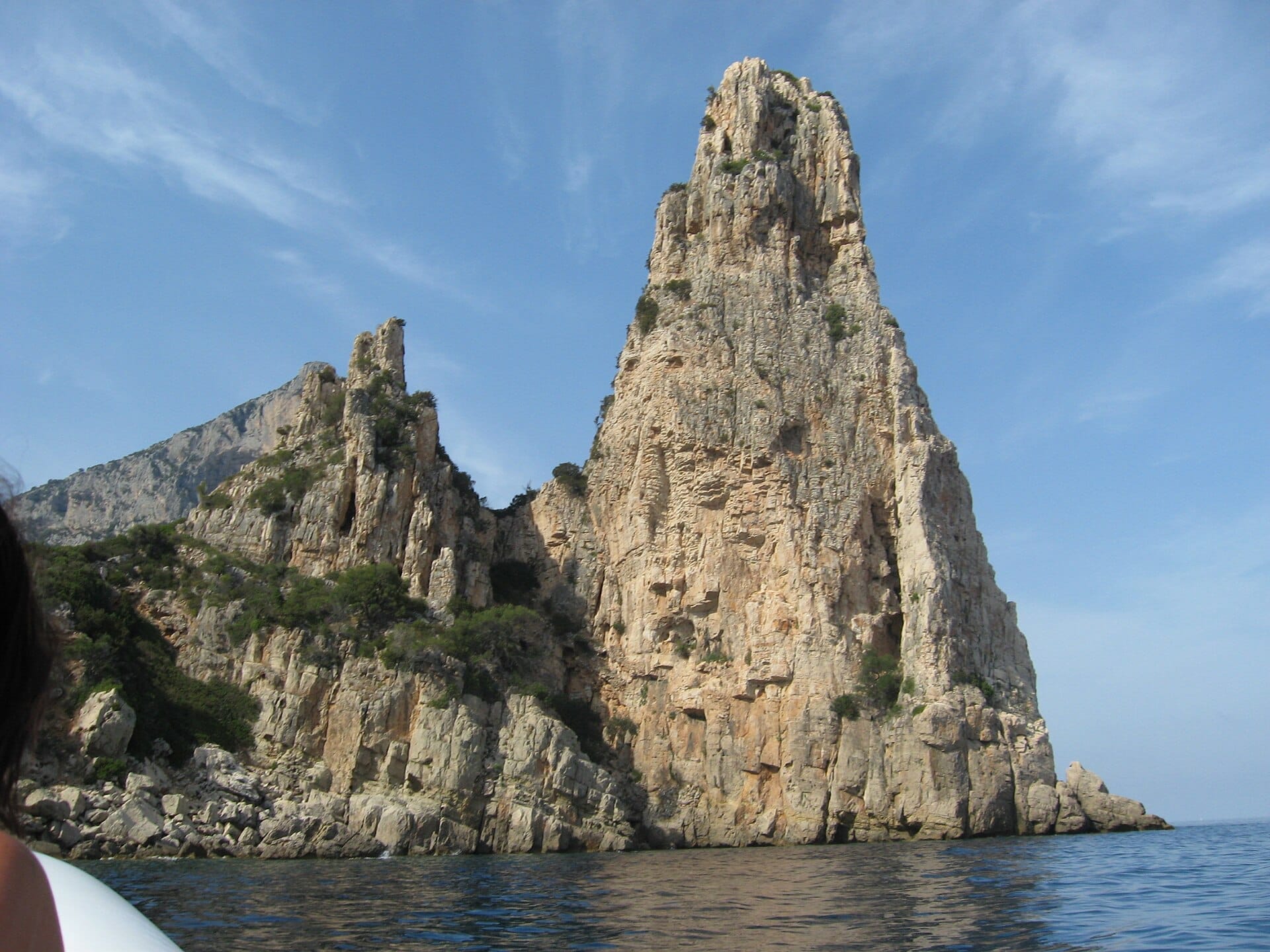
Pedra Longa is a freestanding limestone pinnacle that rises approximately 128 metres directly from the sea on the eastern coast of Sardinia, within the territory of Baunei in the Province of Nuoro. The name means simply 'long stone' in Sardinian, though older maps and local tradition sometimes call it Aguglia or Agugliastra, both meaning 'needle'. The rock was declared a Natural Monument in 1993, recognising what geologists had long understood: this is not just a striking landform but a rare example of a sea stack that separated from the Baunei cliff face in ancient geological time, leaving behind an almost perfectly pyramidal silhouette.
From a distance, the pinnacle looks implausibly thin for its height. Up close, the scale shifts dramatically. The base is surrounded by flat, pale limestone shelves that slope into intensely clear water, and the cliff walls on either side of the cove rise several hundred metres, streaked with rust and grey and occasional patches of macchia scrub clinging to fissures. The overall effect is one of compression: sky, rock, and sea pushed together into a narrow theatre.
ℹ️ Good to know
Pedra Longa sits at the northern end of the Baunei coast accessible by car, and it is the official starting point of the Selvaggio Blu, one of Italy's most demanding long-distance coastal treks. Even if you have no intention of walking that route, the geography and atmosphere at this spot reflect exactly what the Selvaggio Blu is about: wild, vertical, and fully exposed.
How the Landscape Changes Through the Day
Early morning is the most rewarding time to arrive. The SS 125 is quiet before 9am, and when you descend the winding access road toward the cove, the pinnacle is often backlit by low eastern sun, throwing its shadow across the water and making the limestone glow almost orange. The smell at this hour is a mix of salt, sun-warmed rock, and the dry herbs on the surrounding hillsides: rosemary, myrtle, and cistus. Swifts circle the upper section of the pinnacle, audible long before they are visible.
By late morning in summer, the cove begins to fill with boats anchoring offshore and day-trippers arriving by car. The water is shallow enough near the limestone shelves to see the bottom clearly, and the colour shifts from pale turquoise at the edges to a deep cobalt further out. The sound texture changes too: outboard motors, voices off boats, the metallic clunk of anchors. It remains beautiful but noticeably less still.
Late afternoon brings the light around to illuminate the pinnacle from the south and west, and if the sky is clear, the shadows cast by the surrounding cliffs create strong geometric contrasts. By sunset, most casual visitors have left, and the cove returns to quiet. Photographers targeting the golden hour will find that the angle is best in the last 45 minutes before dark, when the limestone takes on a warm amber tone that the midday light never produces.
Tickets & tours
Hand-picked options from our booking partner. Prices are indicative; availability and final rates are confirmed when you complete your booking.
Dinghy tour along the south coast of Sardinia
From 75 €Instant confirmationFree cancellationOne day guided boat tour along the Baunei's coast
From 59 €Instant confirmationFree cancellationTour of Olbia in Tuk-Tuk with a stop at Pittulongu beach
From 80 €Instant confirmationFree cancellationSanta Teresa Gallura, Lu Brandali and Longosardo Tower Ticket
From 15 €Instant confirmationFree cancellation
Geology and Natural Monument Status
The Baunei coast is formed from Mesozoic limestone laid down during a period when much of what is now the central Mediterranean was a shallow tropical sea. Over millions of years, the sea carved the cliffs, and individual sections of the plateau separated from the mainland to form stacks and arches. Pedra Longa is the most photogenic survivor of this process: a pyramidal column standing alone, structurally isolated from the cliffs that surround the cove, rising 128 metres above sea level.
The 1993 Natural Monument designation places Pedra Longa under regional environmental protection, which is why no structures have been built at the base and no permanent commercial facilities exist at the cove itself. The wider coastline falls within the territory of the Golfo di Orosei, an area that combines some of the most geologically significant coastal scenery in the Mediterranean with accessibility that few comparable sites can match.
Getting There: By Car and On Foot
By car, the approach is via the SS 125, the Strada Statale Orientale Sarda, one of Sardinia's most scenic coastal roads. Watch for the signed turnoff near kilometre marker 153, heading south from Baunei. The road is paved but narrow, with a steep descent and several sharp bends. A standard car handles it without difficulty, but larger campervans should approach carefully. Parking is roadside near the cove, with no official tariff listed by the Baunei tourism office.
On foot, the most common approach starts from Santa Maria Navarrese, a small coastal town roughly 10 kilometres south of the cove. The marked path begins near the Bellavista Hostel and takes approximately two hours in each direction. This walk gives you far more of the coastal character than the drive does, and for anyone considering the full Selvaggio Blu trek, this section acts as a useful introduction to the terrain.
💡 Local tip
There is no public transport to Pedra Longa itself. If you do not have a car, the on-foot approach from Santa Maria Navarrese is the only realistic option. Arrange transport or accommodation in Santa Maria Navarrese in advance, particularly in July and August when options fill quickly.
Pedra Longa is approximately 4 kilometres east of Baunei and 10 kilometres south of Cala Goloritzè, another landmark on this coast that is reachable only by boat or on foot. A boat excursion from Cala Gonone that covers the full Golfo di Orosei coast will typically pass Pedra Longa as one of its named stops.
The Cove, the Water, and the Rock Base
The shoreline at Pedra Longa is entirely rocky. There is no sand. The stone platforms are pale grey limestone, smooth in places where the sea has worked them over centuries, and jagged at the water's edge where the surface is rougher. Sturdy water shoes are strongly recommended if you plan to enter the water, because the combination of wet limestone and irregular edges makes bare feet uncomfortable and occasionally hazardous.
Snorkelling directly at the base of the pinnacle is possible and worthwhile. The water clarity is exceptional, and the underwater rock faces descend steeply, creating a layered environment visible even from the surface on a calm day. Given the remoteness of the cove and limited boat traffic in the morning hours, the water is often undisturbed enough to see well into the distance. Bring your own mask and fins, as no equipment is available for hire at the site.
⚠️ What to skip
The stone platforms slope toward the water in places. In swell conditions, even modest wave action makes the edges slippery and dangerous. Check sea conditions before approaching the water's edge, particularly outside the summer months when the Mistral and Scirocco can pick up without warning.
Photography: What Works and What Doesn't
The pinnacle is photogenic in almost any light, but the composition problem is one of scale. Standing at the base, the rock fills the frame and loses its context. The most effective photographs tend to be taken from the access road on the way down, where a medium telephoto lens can frame the pinnacle against the open sea with the surrounding cliff walls visible for scale. A wide angle at the base can work well in the early morning when the reflections in the water are still and the light is directional.
Drone photography is subject to Italian airspace regulations, and parts of the Golfo di Orosei coastline fall within protected natural areas where drone use may be restricted. Check current regulations with the Sardinian regional authority before flying. Standard handheld camera work from the road, the parking area, and the limestone platforms covers most of what you need.
Accessibility and Who Should Skip This
Pedra Longa is not wheelchair accessible. The access road ends at a parking area, and the descent to the cove involves stone staircases and uneven rocky terrain. There are no paved paths to the water, and no facilities at the site: no toilets, no shade structures, no refreshment stands. Visitors with limited mobility can still appreciate the view from the road and parking area, which offers a clear sightline to the pinnacle, but reaching the shoreline requires physical effort and sure footing.
Visitors looking for a beach holiday with sand, sunbeds, and nearby services will find Pedra Longa frustrating. This is a raw natural site, not a beach resort. If that kind of infrastructure matters to you, the broader best beaches in Sardinia guide covers options that are better suited to that style of visit. Similarly, families with very young children should be aware that the rocky shoreline requires constant supervision near the water.
Combining Pedra Longa with the Surrounding Area
Pedra Longa fits naturally into a drive along the SS 125, which is one of Sardinia's most rewarding road routes. The stretch between Baunei and Tortolì passes through the heart of the Ogliastra coast, with multiple viewpoints and smaller access roads leading to further coves. A Sardinia road trip that includes this section of the east coast can reasonably combine Pedra Longa with Cala Goloritzè by boat, the Gola di Su Gorropu inland, and the distinctive rock formations further south toward Arbatax.
For those drawn to the wider coastal landscape of the Golfo di Orosei, the area around Cala Luna and Cala Mariolu offers complementary experiences, though both require boat access or serious trekking to reach. Pedra Longa is, in that sense, the most accessible point of entry into this otherwise demanding coastline.
Insider Tips
- Arrive before 9am in summer if you want the cove to yourself. By 10:30am, boats begin anchoring offshore and foot traffic from the road increases significantly.
- The best overall view of the pinnacle in context is not from the cove itself but from a bend in the access road about 300 metres above the water. Stop here on the way down before committing to the descent.
- Water shoes with a rubber sole are essential for moving comfortably on the wet limestone platforms near the water. They also make snorkelling entry considerably easier.
- If you are driving south on the SS 125, the turnoff for Pedra Longa is easy to miss. The sign is small and appears shortly after a long straight section of road. Slow down around kilometre marker 153 and watch for it on your left when heading south from Baunei.
- The hiking path from Santa Maria Navarrese is the correct approach if you want to understand why Pedra Longa matters as a geographic landmark. The walk puts the scale of the Baunei cliffs in full context in a way that arriving by car simply cannot.
Who Is Pedra Longa For?
- Photographers seeking dramatic coastal geology with minimal infrastructure in the frame
- Trekkers planning or researching the Selvaggio Blu, which begins here
- Drivers following the SS 125 east coast route who want a stop with genuine visual impact
- Snorkellers looking for clear, relatively undisturbed water in a sheltered cove
- Geology and natural history travellers interested in Mediterranean coastal landform development
Nearby Attractions
Other things to see while in Golfo di Orosei:
- Cala Goloritzè
Cala Goloritzè is a protected natural monument on Sardinia's eastern coast, where a limestone pinnacle of about 143–148 metres towers over a pebble beach and crystalline water. Accessible only by a moderately strenuous hike or by sea, it rewards the effort with scenery that few coves in the Mediterranean can match.
- Cala Gonone
Cala Gonone is a small seaside town tucked beneath limestone cliffs on Sardinia's eastern coast, serving as the main launch point for the Golfo di Orosei's famous sea caves, secluded coves, and dramatic hiking routes. Whether you arrive by boat, bus, or car, this is where the real adventure begins.
- Cala Luna
Cala Luna is an 800-metre crescent of pale pink-tinged sand framed by limestone cliffs that rise up to 300 metres above the waterline. Straddling the municipal boundary between Baunei and Dorgali in the Gulf of Orosei, it has no road access and only minimal seasonal beach infrastructure — which is precisely why it looks the way it does.
- Cala Mariolu
Tucked beneath the limestone cliffs of Costa di Baunei, Cala Mariolu is one of the eastern Sardinian coast's most extraordinary beaches. Famous for its white pebble shore, improbably clear water, and sheer rock walls rising hundreds of metres, it demands effort to reach but rewards accordingly. This guide covers every access route, the new reservation system recently introduced to manage visitor numbers, and what first-time visitors consistently get wrong.