Martin Goodman Trail: Toronto's Complete Waterfront Route
Stretching 56 kilometres along the Lake Ontario shoreline, the Martin Goodman Trail is Toronto's primary waterfront corridor for cycling, running, and walking. Free and open year-round, it connects landmark parks, public beaches, and cultural institutions from the Humber Bay Arch Bridge in the west to the Rouge River in the east.
Quick Facts
- Location
- Toronto Waterfront, Lake Ontario shoreline, from Humber Bay Arch Bridge (west) to Rouge River (east)
- Getting There
- Union Station (Line 1/2), then streetcar 509 or 510 to Queen's Quay; multiple TTC stops along the central waterfront
- Time Needed
- 30 min (short segment) to a full day (full route); most visitors explore a 5–10 km central stretch in 1–2 hours
- Cost
- Free; no admission fee
- Best for
- Cyclists, joggers, waterfront walkers, and anyone wanting uninterrupted views of Lake Ontario
What the Trail Actually Is
The Martin Goodman Trail is a multi-use, paved waterfront path that runs 56 kilometres along Toronto's Lake Ontario shoreline. Established in 1984 and named after the late Toronto Star president and editor-in-chief Martin Goodman, it forms the urban spine of Toronto's waterfront trail network and is also designated as part of the Great Lakes Waterfront Trail and the Waterfront Trail around Lake Ontario. In French, signage refers to it as the Sentier Martin-Goodman.
The trail is not a wilderness path. It is a wide, well-maintained urban greenway shared by cyclists, inline skaters, joggers, and pedestrians. In most sections there are separate lanes or at least marked separations between cycling and walking traffic, though the busiest central stretches around Queen's Quay and Harbourfront Centre can feel genuinely congested on warm weekend afternoons. The surface is smooth asphalt throughout the majority of the route, making it accessible to road bikes, strollers, and most mobility aids.
💡 Local tip
You do not need to walk or ride the full 56 km to get value from this trail. The 4–6 km central segment between Humber Bay Arch Bridge and the Distillery District area offers the highest concentration of views, amenities, and connecting attractions.
How the Trail Feels at Different Times of Day
Early mornings on the Martin Goodman Trail are genuinely different from midday. Between 6 and 8 a.m., especially on weekdays, the path belongs to commuter cyclists and dedicated runners. The lake is usually still, the CN Tower reflects off the water in low light, and the smell of lake air is cleanest before urban traffic builds. Geese and ring-billed gulls congregate along the rocky shoreline edges, particularly near Sugar Beach and the Sherbourne Common stretch.
By late morning on weekends from May through September, the central section becomes a social space as much as a sports corridor. Families with strollers, tourists on rental bikes, and groups of inline skaters all compete for the same paved width. Vendors, pop-up markets, and outdoor events at Harbourfront Centre add noise and foot traffic that slow any serious ride. If you are cycling for fitness rather than sightseeing, this window is not ideal.
Late afternoon in summer brings a different energy: the light on Lake Ontario turns warm and golden, and the trail west of Ontario Place toward Humber Bay quiets noticeably. This western stretch passes through Humber Bay Park, where the path curves around a peninsula with open water on three sides, giving the closest thing to a countryside feel within city limits. Sunsets from this section, with the downtown skyline behind you and the lake ahead, are among Toronto's more reliable photographic rewards.
In winter, the trail does not close. Sections are maintained to varying standards depending on snowfall, and the experience shifts completely. The lake takes on a grey, muscular quality, ice forms along the rocky edges, and the path is near empty. A small number of bundled walkers and hardy cyclists use it year-round. It is a legitimate winter activity if you dress appropriately for Toronto's January temperatures, which average around -4°C but regularly drop lower with wind chill off the lake.
Tickets & tours
Hand-picked options from our booking partner. Prices are indicative; availability and final rates are confirmed when you complete your booking.
Toronto Old Town: Dark Side Exploration Game and Tour
From 12 €Instant confirmationFree cancellationLEGOLAND Discovery Centre Toronto tickets
From 16 €Instant confirmationFree cancellationToronto 'Little Canada' entrance tickets
From 27 €Instant confirmationFree cancellationNiagara Falls evening tour with boat, dinner and Illumination Tower
From 77 €Instant confirmationFree cancellation
The Western Section: Humber Bay to Ontario Place
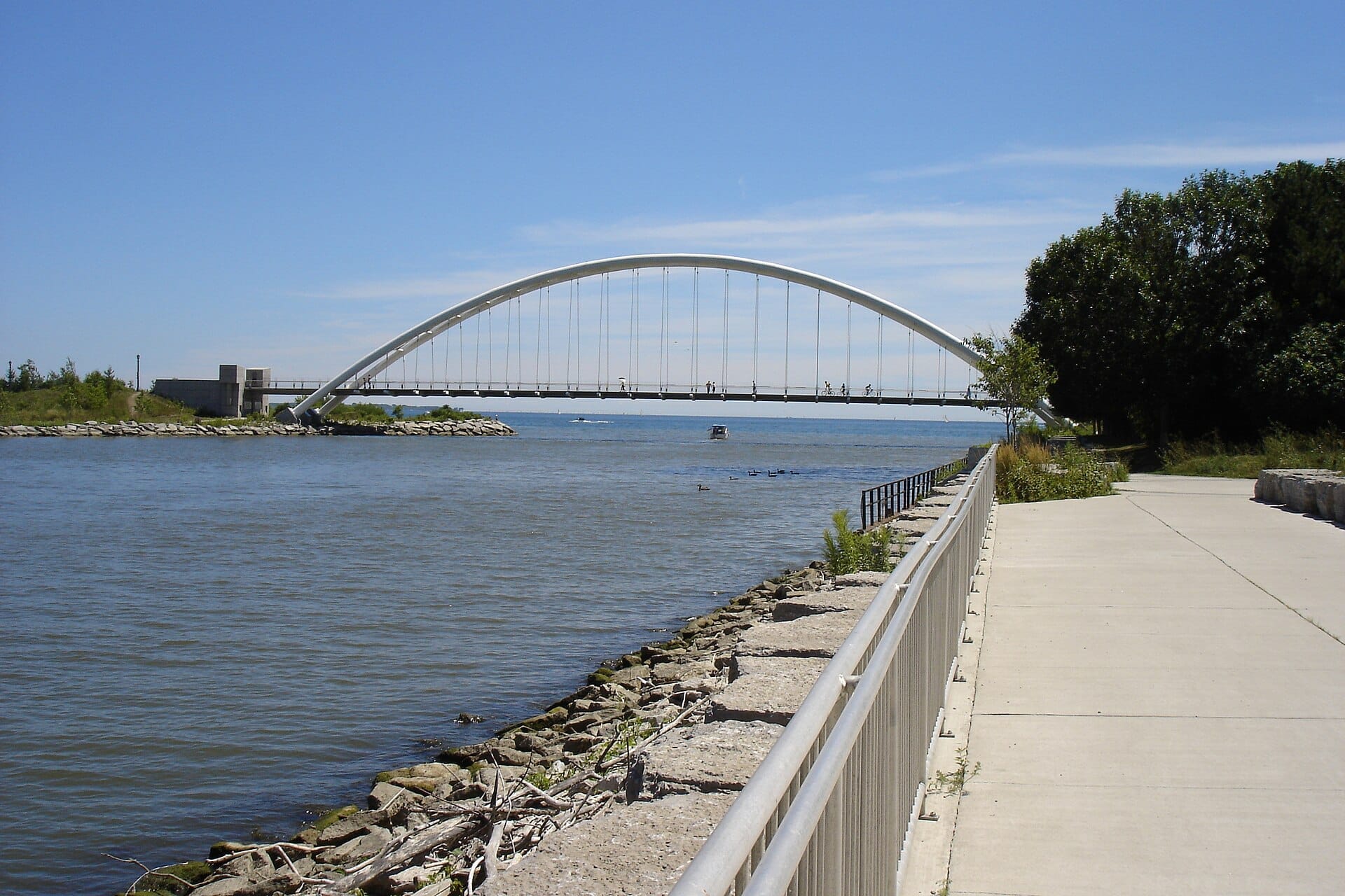
The trail's western anchor is the Humber Bay Arch Bridge, a distinctive pedestrian and cycling span over the mouth of Mimico Creek. The twin steel arches are one of the more photographed pieces of infrastructure on the waterfront, and the view from the bridge's midpoint includes the Toronto skyline to the east and open lake to the south. From here the trail runs northeast through Humber Bay Park, a relatively wide green corridor with waterfront benches and fishing spots that draw a noticeably different crowd than the busier central sections.
Continuing east, the trail passes through the Ontario Place grounds. Waterfront Toronto has described the Ontario Place segment of the Martin Goodman Trail as barrier-free and accessible to all users. This section connects well with the broader Humber Bay Arch Bridge viewpoint area and provides a relatively quiet alternative to the crowded central waterfront on peak days.
The Central Section: Harbourfront to the Distillery Area
The stretch between Coronation Park and the Sherbourne Common area is where the trail intersects with the highest density of visitor attractions. Harbourfront Centre sits directly alongside the path, and on summer weekends it hosts outdoor concerts, markets, and cultural events that spill onto the trail itself. The CN Tower is visible throughout this section, rising directly behind the Rogers Centre to the north.
Sugar Beach and Sherbourne Common are both formal public spaces integrated into this segment. Sugar Beach, with its pink umbrellas and sandy shore adjacent to the lake, offers a deliberate pause point with seating and water features. Just east, Sugar Beach connects visually to the working waterfront, with the Redpath Sugar Refinery as an intentional industrial backdrop. It is a specific Toronto juxtaposition that the trail makes visible.
This central section is where the trail's signage and lane markings are most consistent, and where bike share (Bike Share Toronto) docking stations appear most frequently. If you do not own a bike and want to ride a segment of the trail, this is the easiest area to pick up and drop off a rental.
⚠️ What to skip
The central waterfront section between Queen's Quay West and Sherbourne Street is heavily used on summer weekends. Cyclists should anticipate slow speeds and frequent stopping near Harbourfront Centre. Plan for pedestrian-pace conditions rather than a continuous ride during peak hours.
The Eastern Section: Tommy Thompson Park and Beyond
East of the central waterfront, the trail character changes significantly. The Leslie Street Spit area, formally known as Tommy Thompson Park, is one of Toronto's more unusual natural areas: a man-made peninsula built from construction fill that has evolved into a significant migratory bird habitat. The trail passes near the park's entrance at Leslie Street, and a detour into the spit itself (open on weekends) takes cyclists and walkers into a quiet, ecologically rich environment that contrasts sharply with the urban intensity of the central waterfront.
Continuing east toward Woodbine Beach and beyond, the trail runs along a more residential and less tourist-oriented shoreline. The Beaches neighbourhood brings its own community of regular trail users, with a boardwalk running parallel to the paved trail in places. The lake views are uninterrupted here, and the absence of major attractions means fewer crowds even in peak season.
Practical Information for Visitors
The trail is free and has no set opening or closing hours. It is generally considered open year-round, with maintenance and conditions varying by season and weather. There are no entry points to pass through; you simply access the trail from any of the waterfront parks, streets, or transit stops along the lakeshore.
The most convenient transit access to the central section is via Union Station (TTC Lines 1 and 2), then the 509 or 510 streetcar along Queen's Quay West to stops near Harbourfront Centre or Rees Street. For more on navigating Toronto's public transit network, the getting around Toronto guide covers TTC routes and fares in detail.
Photography along the trail is best in the early morning (light from the east catches the downtown skyline across the water) and in the hour before sunset in the western sections near Humber Bay. A wide-angle lens handles the skyline-plus-water compositions well. The trail surface is uniformly lit in summer but can be icy and shadowed in winter mornings, so check conditions before an early cold-weather visit.
Accessibility is strong throughout most of the route. The Ontario Place segment is documented as fully barrier-free by Waterfront Toronto, and the majority of the paved surface is navigable by wheelchair and mobility devices. Sections near Tommy Thompson Park and the eastern stretches may have less consistent surface quality. For a broader overview of what the waterfront area offers, the Toronto waterfront guide provides context on surrounding parks and amenities.
ℹ️ Good to know
Bike Share Toronto docking stations are concentrated along the central waterfront section. The system requires a membership or day pass; check the Bike Share Toronto app for real-time dock availability before heading out.
Who Will Not Enjoy This Trail
Visitors looking for a natural, off-road trail experience will find the Martin Goodman Trail too urban and too crowded in its central sections. The trail is essentially a city path alongside a working waterfront, not a nature escape. For genuine green immersion, Toronto's ravine trails offer a more secluded experience.
Travelers with only a few hours in Toronto and a long list of ticketed attractions to cover may find that the trail works best as a connective route rather than a destination on its own. It is genuinely useful for getting between the CN Tower area and the Distillery District on foot or by bike, rather than a standalone experience worth blocking time for.
Insider Tips
- The western section between Humber Bay Park and Ontario Place is consistently quieter than the central waterfront, even on summer weekends. If you want uninterrupted riding or running, start here rather than at Queen's Quay.
- For the best skyline photography from the trail, position yourself at the midpoint of the Humber Bay Arch Bridge around 7–8 a.m. on a clear morning. The low eastern light hits the downtown towers directly and the lake surface reflects the sky.
- Bike Share Toronto docking stations along Queen's Quay allow you to pick up a bike near Union Station and drop it near the Distillery District, covering the most scenic central segment as a one-way trip without backtracking.
- Tommy Thompson Park (Leslie Street Spit) is primarily open to the public on weekends and holidays, with limited weekday access for certain areas and uses. If you are planning to ride east and divert into the spit, confirm it is open before building it into your route.
- In winter, the stretch near Sherbourne Common is often cleared earlier than other sections because it receives foot traffic from the adjacent residential towers. It is one of the more reliable year-round segments when snow or ice is a concern.
Who Is Martin Goodman Trail For?
- Cyclists looking for a long flat urban ride with continuous lake views
- Runners wanting a measured, surface-consistent route along the waterfront
- Visitors connecting between western waterfront parks and the central Harbourfront area on foot or bike
- Birdwatchers using the trail as access to Tommy Thompson Park during weekend opening hours
- Photographers targeting the Toronto skyline from waterfront angles at golden hour
Nearby Attractions
Other things to see while in Toronto Waterfront:
- BMO Field
BMO Field at Exhibition Place is Toronto's premier outdoor soccer stadium, home to Toronto FC and the Toronto Argonauts. Originally built in 2007 and expanded since, it will serve as a FIFA World Cup 2026 venue. Here is everything a first-time visitor needs to know before heading to a match or event.
- Budweiser Stage
Formerly known as Budweiser Stage, the RBC Amphitheatre is a major outdoor concert venue on the Lake Ontario waterfront at Ontario Place. With a capacity of around 16,000, it draws major international acts from May through October each year. Here is everything you need to know before attending a show.
- Exhibition Place
A 192-acre event and heritage campus on Toronto's western waterfront, Exhibition Place has anchored the city's civic and cultural life since 1879. Home to the Canadian National Exhibition, major concerts, trade shows, and several sports venues, the grounds offer free outdoor access year-round with a remarkable collection of early 20th-century buildings.
- Harbourfront Centre
Harbourfront Centre is a 10-acre arts and cultural campus on Toronto's waterfront, open year-round with free public access to outdoor spaces, plus ticketed performances, exhibitions, and events. It sits about a 15-minute walk from Union Station and offers a direct view across Lake Ontario.