Humber Bay Arch Bridge: Toronto's Waterfront Icon on the Martin Goodman Trail
The Humber Bay Arch Bridge spans the mouth of the Humber River along Toronto's Lake Ontario waterfront, connecting the Martin Goodman Trail across a graceful double-ribbed steel arch. Free to access at any hour, it offers some of the city's most dramatic skyline views and carries quiet but significant cultural meaning in its design.
Quick Facts
- Location
- Mouth of the Humber River, Lake Ontario waterfront, near Humber Bay Park — south of Lake Shore Blvd W, Toronto
- Getting There
- TTC buses along Lake Shore Blvd W; walk south to the waterfront trail. The bridge is best reached by cycling or walking the Martin Goodman Trail.
- Time Needed
- 30–60 minutes for the bridge and immediate surroundings; 2–3 hours if combining with Humber Bay Park
- Cost
- Free — no admission fee, open 24 hours year-round
- Best for
- Cyclists, walkers, photographers, skyline hunters, and anyone exploring the waterfront trail
What the Humber Bay Arch Bridge Actually Is
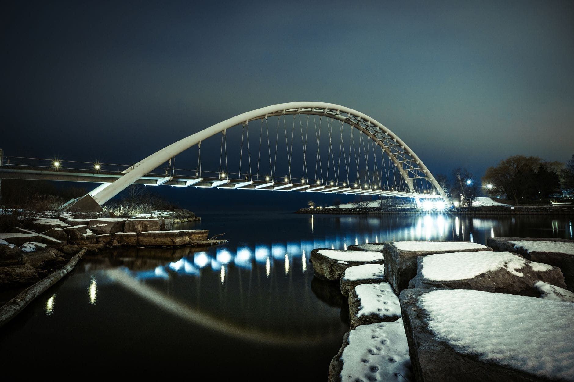
The Humber Bay Arch Bridge is a pedestrian and cycling bridge that crosses the mouth of the Humber River where it empties into Lake Ontario. Opened in 1994, it forms a critical link in the Martin Goodman Trail, Toronto's continuous waterfront path. The bridge spans roughly 139 metres (456 feet), rises about 36 feet above the water at its highest point, and carries a deck approximately 6.5 metres (21 feet) wide — wide enough that cyclists and walkers rarely feel crowded, even on busy weekends.
This is not a grand suspension bridge or a tourist attraction in the conventional sense. There are no ticket booths, no guided tours, no gift shops. What there is: a genuinely striking piece of urban infrastructure that rewards anyone who slows down to look at it properly, sitting at the edge of a city of nearly three million people, framing the CN Tower and the downtown skyline across the water.
ℹ️ Good to know
The bridge is also referred to as the Humber River Arch Bridge, the Humber River Pedestrian Bridge, and occasionally the Gateway Bridge. All names refer to the same structure.
Architecture and Cultural Significance
The bridge was co-designed by Montgomery Sisam Architects as more than a functional crossing. Its geometry references the historic Toronto Carrying-Place Trail, the ancient Indigenous portage route that ran along the Humber River corridor for thousands of years, connecting Lake Ontario to Lake Simcoe. The decorative metalwork incorporates Thunderbird-inspired geometric patterns as a deliberate acknowledgment of that heritage.
Structurally, the bridge uses a double-ribbed steel arch system with 44 stainless steel hangers suspending the deck below. The arches lean inward toward each other, giving the profile a distinctive silhouette — particularly visible from the eastern shoreline of Humber Bay or from the water itself. At night, lighting traces the arch and hanger lines, turning the bridge into a landmark even in the dark.
For visitors interested in Toronto's built environment, the bridge sits comfortably alongside other examples of civic design that takes its setting seriously. It was built at a time when the city was investing in connecting its fragmented waterfront, and it shows that ambition in its proportions and detail.
If architecture interests you beyond the bridge itself, the broader waterfront guide Toronto architecture guide covers the city's range of significant structures, from Victorian civic buildings to contemporary landmark towers.
Tickets & tours
Hand-picked options from our booking partner. Prices are indicative; availability and final rates are confirmed when you complete your booking.
Toronto Old Town: Dark Side Exploration Game and Tour
From 12 €Instant confirmationFree cancellationLEGOLAND Discovery Centre Toronto tickets
From 16 €Instant confirmationFree cancellationToronto 'Little Canada' entrance tickets
From 27 €Instant confirmationFree cancellationNiagara Falls evening tour with boat, dinner and Illumination Tower
From 77 €Instant confirmationFree cancellation
What the Visit Feels Like at Different Times of Day
Early morning, before 8am, the bridge belongs to serious cyclists and solitary dog walkers. The light from the east catches the stainless steel hangers and makes them gleam against the grey-green surface of Lake Ontario. On still mornings, the water beneath reflects the arch nearly perfectly. The sounds are mostly wind, the soft hiss of bicycle tyres on the smooth deck, and distant lakeshore birds.
By mid-morning on weekends, the character shifts. Families arrive on bikes, joggers pass through in both directions, and photographers set up on the railings facing downtown. The deck is wide enough to accommodate all of this without becoming chaotic, but it is noticeably busier. Summer weekends between 10am and 2pm represent peak traffic.
Sunset is the period most photographers specifically seek out. Standing on the bridge's midpoint and looking east-southeast, you have an unobstructed sightline to the CN Tower and the downtown core, silhouetted against whatever the sky is doing. On clear evenings in autumn and late spring, this view is genuinely hard to match from ground level in Toronto. The light turns the steel arch amber, and the lake surface takes on colour for thirty minutes or so before losing it quickly.
At night, the bridge is accessible and lit well enough to feel safe, though the surrounding trail through Humber Bay Park West becomes darker further from the bridge itself. The city skyline across the water, with the CN Tower lit in whatever colour scheme it is running that night, reflects in the river mouth directly below the deck.
💡 Local tip
For the best skyline photography, position yourself on the bridge's eastern railing in the final hour before sunset. Face toward downtown Toronto and wait for the light to drop behind you. Late September through November often produces the clearest skies and warmest light colours.
Getting There: Practical Route Options
The most natural way to arrive is by bike or on foot along the Martin Goodman Trail. From downtown, the trail runs continuously westward along the waterfront, passing Harbourfront, Exhibition Place, and Humber Bay Park East before reaching the bridge. The ride from downtown takes roughly 40–60 minutes at a relaxed cycling pace, and the route is almost entirely flat and paved.
If you are planning a longer waterfront route, the Martin Goodman Trail Martin Goodman Trail runs the full length of Toronto's lakeshore and connects the bridge to the broader waterfront network east and west.
By public transit, TTC bus routes along Lake Shore Boulevard West bring you to within a 10–15 minute walk of the waterfront trail. From that point, head south toward the lake and follow the paved trail west to the bridge. Check the TTC's current route schedules before you go, as service frequency varies by time of day.
Driving is possible but slightly awkward. There is parking available at Humber Bay Park East and Humber Bay Park West, but spaces fill quickly on warm weekends. Lake Shore Boulevard West runs close to the area, but the bridge itself is not accessible by car — you will park and walk in. Budget 10–15 minutes on foot from either park parking lot.
⚠️ What to skip
Parking at Humber Bay Park fills by mid-morning on summer weekends. If you are driving, arrive before 9am or consider combining with a transit trip to avoid frustration.
Combining the Bridge with Humber Bay Park
The bridge does not exist in isolation. On both sides of the Humber River mouth, Humber Bay Park East and West extend along the shoreline, offering open green space, a wetland habitat, and unobstructed views across Lake Ontario. The parks are popular with birdwatchers during migration season, particularly in spring and autumn when the lakeshore acts as a natural funnel for birds crossing the water.
Humber Bay Park is one of Toronto's more underused waterfront assets — visitors focused on the waterfront guide downtown core often miss it entirely. For a fuller picture of what the city's lakeshore offers, the Toronto waterfront guide maps out the full range of parks, trails, and points of interest along Lake Ontario.
In winter, the area around the bridge takes on a different quality. When temperatures drop far enough, sections of the river mouth freeze, and the bridge deck gets dusted with snow. The stainless steel hangers develop a faint frost coating. Foot traffic drops sharply, and the experience becomes genuinely quiet in a way that the summer version never quite manages. Dress in proper winter layers — the waterfront is exposed, and wind off the lake drops the perceived temperature significantly below what the thermometer reads.
Photography Notes and Practical Tips
The bridge photographs well in both directions. Looking east from the midpoint, you frame the CN Tower and the cluster of downtown skyscrapers. Looking west, you get the arch structure itself against the open sky and the Etobicoke shoreline. Bring a wide-angle lens or use your phone's ultra-wide mode to capture the full arc of the hangers above you when standing on the deck.
Drone operators should be aware that the area sits within the flight path corridors associated with Billy Bishop Toronto City Airport. Check current Transport Canada drone flight restrictions before flying. At ground level, though, the approach shots from Humber Bay Park East looking west toward the bridge give clean architectural compositions with water in the foreground.
The deck surface is smooth and even, making it accessible to most wheeled mobility devices. Approach paths via the Martin Goodman Trail are paved and relatively flat. There are no stairs required on the main route. Visitors with specific accessibility questions should consult the City of Toronto's waterfront accessibility information for current conditions.
Who This Attraction Suits (and Who It Does Not)
The Humber Bay Arch Bridge is straightforwardly enjoyable for cyclists, runners, and anyone who finds satisfaction in walking through a well-designed piece of urban infrastructure with good views on either side. It works equally well as a destination in its own right and as a waypoint on a longer waterfront ride.
For visitors building a full day on the waterfront, this bridge pairs naturally with a visit to Harbourfront Centre to the east, or with time in Humber Bay Park on either side of the river.
Visitors looking for indoor experiences, historical exhibitions, or dense cultural programming will find the bridge a brief stop rather than a centrepiece. It is an outdoor infrastructure landmark, not a museum or venue. In heavy rain or during Toronto's coldest winter weeks, the exposed lakeshore location makes the experience less pleasant — the bridge itself stays open, but the walk there is genuinely cold and wet when conditions are poor.
Travellers on a tight schedule who are not specifically focused on the waterfront trail may find the journey from downtown takes more time than the bridge itself warrants as a standalone destination. That said, it fits well into any plan that already includes the western waterfront.
Insider Tips
- The best unobstructed photograph of the full arch is taken from the eastern shore of Humber Bay Park, looking westward across the river mouth toward the bridge — not from the deck itself. Get down near water level if the shoreline allows for maximum reflection.
- On weekday mornings between 6am and 8am, the bridge is almost empty. You will have the deck to yourself, the light is good for photography, and the walk through Humber Bay Park is genuinely peaceful before the city wakes up.
- The bridge deck is slightly higher at its midpoint than at either approach. That midpoint gives the cleanest sightline to the CN Tower — stand at the highest point of the arc and look east-southeast for the classic composition.
- In late April and early May, the Humber River corridor is an active migration route. Birdwatchers who arrive at dawn during spring migration sometimes spot warblers and other neotropical migrants in the vegetation flanking the trail approaches.
- If you are cycling the full Martin Goodman Trail westward from downtown, the bridge marks a natural break and turnaround point before the trail continues into Etobicoke. Total one-way distance from Union Station area is roughly 14–15 km.
Who Is Humber Bay Arch Bridge For?
- Cyclists completing the Martin Goodman Trail or planning a full waterfront ride
- Photographers chasing Toronto skyline shots at golden hour
- Walkers and joggers who want a scenic, car-free route along Lake Ontario
- Architecture enthusiasts interested in Toronto's civic infrastructure and Indigenous design references
- Families looking for an easy, free outdoor outing with open space nearby at Humber Bay Park
Nearby Attractions
Other things to see while in Toronto Waterfront:
- BMO Field
BMO Field at Exhibition Place is Toronto's premier outdoor soccer stadium, home to Toronto FC and the Toronto Argonauts. Originally built in 2007 and expanded since, it will serve as a FIFA World Cup 2026 venue. Here is everything a first-time visitor needs to know before heading to a match or event.
- Budweiser Stage
Formerly known as Budweiser Stage, the RBC Amphitheatre is a major outdoor concert venue on the Lake Ontario waterfront at Ontario Place. With a capacity of around 16,000, it draws major international acts from May through October each year. Here is everything you need to know before attending a show.
- Exhibition Place
A 192-acre event and heritage campus on Toronto's western waterfront, Exhibition Place has anchored the city's civic and cultural life since 1879. Home to the Canadian National Exhibition, major concerts, trade shows, and several sports venues, the grounds offer free outdoor access year-round with a remarkable collection of early 20th-century buildings.
- Harbourfront Centre
Harbourfront Centre is a 10-acre arts and cultural campus on Toronto's waterfront, open year-round with free public access to outdoor spaces, plus ticketed performances, exhibitions, and events. It sits about a 15-minute walk from Union Station and offers a direct view across Lake Ontario.