Calle Madero: The Pedestrian Spine of Mexico City's Historic Center
Avenida Francisco I. Madero connects the Zócalo to the Torre Latinoamericana along one of the oldest streets in the Americas. Free to walk at any hour, it layers colonial architecture, street performance, and everyday city life into a single corridor that doubles as an open-air history lesson.
Quick Facts
- Location
- Centro Histórico, Cuauhtémoc, Mexico City (CDMX)
- Getting There
- Zócalo/Tenochtitlan (east end) or Torre Latinoamericana / San Juan de Letrán (west end)
- Time Needed
- 45 minutes to 2 hours depending on stops
- Cost
- Free to walk; shops and attractions have their own prices
- Best for
- History lovers, architecture enthusiasts, first-time visitors to CDMX
What Calle Madero Is
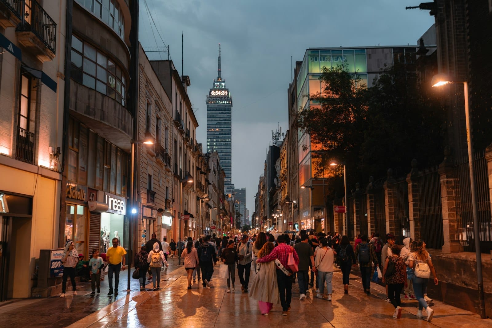
Avenida Francisco I. Madero, known simply as Calle Madero, is a fully pedestrianized street running a little over 600 meters east to west through the heart of the Centro Histórico. At its eastern end sits the Zócalo, one of the largest public squares in the world. At its western end stands the Torre Latinoamericana, the iron-frame skyscraper that punctuates the skyline at the edge of Eje Central. Everything between those two anchors is accessible on foot, free of charge, all day and all night.
The street is wide enough that it never feels claustrophobic even when crowds press in from both directions. The paving is level and continuous, with no curbs separating pedestrians from the central lane, which means the whole width belongs to walkers. Street musicians compete with noise from nearby construction and the general roar of a city of over nine million. It is not a quiet stroll. It is, however, an unusually direct way to feel how Mexico City actually moves.
💡 Local tip
To get the cleanest view of the colonial facades and the fewest people, arrive before 9:00 am on a weekday. The light hits the stone buildings from the east, the street sweepers are finishing their rounds, and the coffee carts are just opening. By 11:00 am on weekends, the crowd density rises substantially.
Five Centuries of Street History
Calle Madero was one of the principal streets laid out by Spanish colonists after the fall of Tenochtitlán in 1521, when the colonial grid was imposed over the Aztec city and this corridor began functioning as a central artery. It was originally called Calle de San Francisco, named for the Franciscan convent that dominated its western stretch. Over the colonial and independence eras, different sections of the street acquired different names, including Plateros, reflecting the silversmiths who operated workshops along it.
The current name honors Francisco I. Madero (1873-1913), the democratic reformer whose election in 1911 marked the political opening of the Mexican Revolution and whose assassination in 1913 helped radicalize the conflict. Renaming the street for Madero was a deliberate act of post-revolutionary memory, placing his name on one of the most-traveled stretches of pavement in the country.
The buildings lining Madero represent nearly every era of that history. Colonial-period churches and baroque palaces stand alongside Porfirian-era commercial buildings from the late 19th century and early 20th-century Italian Renaissance facades built during the economic boom under President Díaz. Nearby, the Metropolitan Cathedral and the Templo Mayor archaeological zone sit just off the eastern end of the street, making Madero a natural first walk for anyone engaging with the Centro Histórico seriously.
Tickets & tours
Hand-picked options from our booking partner. Prices are indicative; availability and final rates are confirmed when you complete your booking.
Puebla and Cholula guided tour from Mexico City with optional lunch
From 43 €Instant confirmationFree cancellationXochimilco, Coyoacan and Frida Kahlo Museum with skip-the-line tickets
From 63 €Instant confirmationFree cancellationMexico City exploration game and tour in Chimalistac
From 10 €Instant confirmationFree cancellationCuernavaca and Taxco Guided Tour with Optional Lunch
From 40 €Instant confirmationFree cancellation
Anchor Buildings Worth Slowing Down For
The Casa de los Azulejos (House of Tiles) is probably the most photographed building on the street. Its exterior is wrapped in blue-and-white Talavera tiles from Puebla, producing a texture that looks almost unreal in direct sunlight. The current palace took its form in the 18th century, and today operates as a Sanborns restaurant and department store, which means you can step inside at no charge to see the atrium courtyard and José Clemente Orozco's 1925 mural Omnisciencia on the staircase landing.
The western end of the street terminates at the Torre Latinoamericana, which opened in 1956 as the tallest building in Latin America. The observation deck on the 44th floor offers a useful orientation to the city grid, though visibility depends heavily on air quality, which is most reliable during the dry season from November to April. Crossing Eje Central to the west brings you immediately to the Palacio de Bellas Artes and the Alameda Central park, both worth incorporating into the same visit.
Smaller details reward closer attention: the carved stone doorways of former convents converted into banks or government offices, the ornate ironwork on second-floor balconies, and the wall plaques marking buildings that survived the 1985 earthquake or that hosted specific historical events. None of these are labeled in obvious ways. Bring a curiosity that allows for pausing and looking upward.
How the Street Changes by Time of Day
Early mornings are when the street has its greatest architectural clarity. The facades are lit by low eastern sun, the vendors have not yet set up their carts, and the only sounds are delivery trucks unloading at side doors and pigeons working the gutters. This window between roughly 7:00 and 9:00 am is markedly different from any other part of the day.
By mid-morning, street food sellers take positions at the junctions with cross streets. Vendors sell fresh-squeezed juice, tacos, churros, and a rotating cast of snacks that depend on the season. The smell of frying oil and corn masa becomes a constant presence. By midday on weekdays, workers from nearby government offices cross the street at pace, and the crowd thickens enough that slow walkers stay to the sides.
Weekend afternoons, particularly Saturdays, bring the highest foot traffic of the week. Street performers, evangelical preachers with portable sound systems, balloon sellers, and school groups all compete for the same space. It can feel overwhelming if you are expecting a meditative experience. It can feel exhilarating if you are not. By Sunday evening the pace slows again, and families from outer neighborhoods who have spent the afternoon at the Zócalo pass back through heading to the Metro.
⚠️ What to skip
Calle Madero attracts pickpockets in proportion to its crowd density. Keep bags zipped and facing forward during weekend afternoons and holidays. The street is safe for walking but common sense about valuables applies at all busy times.
Practical Walkthrough: Getting There and Moving Through
The easiest approach is from the east. Take Metro Line 2 to Zócalo/Tenochtitlan station, exit onto the plaza, and look west. Calle Madero opens directly off the southwest corner of the Zócalo. You can walk the entire length without crossing a vehicle lane, since the street is fully pedestrianized. The flat surface and absence of curbs make it accessible for strollers and wheelchair users, though weekend crowds can make navigation slower.
From the west, Metro Line 2 also serves Bellas Artes station, and Line 8 serves San Juan de Letrán, both within a one-block walk of the Torre Latinoamericana end. If you are arriving from Roma or Condesa by Metrobús, Line 4 along Eje Central can drop you nearby. Walking the street from west to east puts the Zócalo at the end of the walk rather than the beginning, which means you arrive at the wide open plaza as a payoff rather than a starting point.
For a structured way to understand the surrounding area, organized walking tours of the Centro Histórico typically include Madero as a core segment. If you prefer to navigate independently, the Centro Histórico neighborhood guide covers the full district context.
ℹ️ Good to know
The street is open 24 hours as a public thoroughfare. Evening and nighttime are quieter and offer a different atmosphere, with illuminated facades and far less foot traffic. The area around the Zócalo is patrolled and generally active well into the night, but exercise standard urban awareness after midnight.
Photography Notes
The blue-and-white tiles of Casa de los Azulejos photograph best under diffuse cloud cover or in the shade of early morning, when direct sunlight does not blow out the white sections. The eastern view down Madero toward the Zócalo works well in the hour after sunrise, with the cathedral dome visible at the far end of the corridor. A wide or standard lens is more practical than a telephoto in the compressed space of the street during busy hours.
Looking upward consistently reveals more detail than looking straight ahead. The upper stories of buildings on Madero were designed for civic display in ways that the street-level retail interiors no longer reflect. Carved stone cartouches, colonial-era religious reliefs built into commercial facades, and decorative ironwork are all more visible from the middle of the pedestrian street than from the sidewalk.
Insider Tips
- Enter the Sanborns inside Casa de los Azulejos for the Orozco mural on the staircase. Most visitors photograph the tiled exterior and keep walking. The interior courtyard and the 1925 mural are free to see and almost always less crowded than the street outside.
- The cross street at Isabel la Católica intersects Madero roughly at the midpoint and leads one block south to the Museo del Palacio de Bellas Artes neighborhood. It also leads north to Santo Domingo Square, one of the quieter colonial plazas in the center, where scribes still operate traditional typing and document services from metal stalls.
- If you are visiting on a weekday, the government buildings along the street sometimes have open courtyards accessible from ground-floor entrances. These patios are colonial or Porfirian and often completely empty of tourists. Knock or ask the security staff at the entrance.
- The area directly in front of the Torre Latinoamericana at Eje Central is a useful orientation point for the whole center. From here, Alameda Central is one block northwest, Bellas Artes is visible directly ahead, and Madero stretches east to the Zócalo. It takes about 10 minutes to walk the full length at a moderate pace without stopping.
- For context on the street's place in Mexican political history, the building at Madero 17 was a key location during various 20th-century political events. Small plaques and memorial markers throughout the block reward visitors who read the walls as well as the facades.
Who Is Calle Madero For?
- First-time visitors to Mexico City who want a direct introduction to the Centro Histórico without a structured tour
- Architecture and history enthusiasts who can move slowly and read buildings across multiple colonial and modern periods
- Photographers working in the early morning hours when the light and crowd conditions are most favorable
- Travelers combining multiple Centro Histórico sites in a single day, since Madero connects the Zócalo cluster to the Alameda and Bellas Artes cluster on foot
- Budget travelers: the walk itself is free, street food along the route is inexpensive, and several major buildings can be entered at no cost
Nearby Attractions
Other things to see while in Centro Histórico:
- Alameda Central
Founded in 1592, Alameda Central is the oldest public park in the Americas and the green centerpiece of Mexico City's historic center. Flanked by the Palacio de Bellas Artes and a ring of colonial-era institutions, it offers free entry, shaded walkways, and a front-row seat to everyday city life.
- Casa de los Azulejos
Casa de los Azulejos is one of the most photographed facades in Mexico City, its exterior wrapped in blue-and-white Talavera tiles from Puebla. With documented origins in the 16th century and operating as a Sanborns restaurant since 1919, it offers free entry and a rare chance to step inside a baroque palace that has survived centuries of history.
- La Ciudadela Artisan Market
The Mercado de Artesanías de La Ciudadela is one of Mexico City's largest and best-known handicraft markets, with more than 350 vendors selling handmade goods from across 22 states. Entry is free, quality ranges from tourist trinkets to serious collector pieces, and knowing how to navigate the stalls makes all the difference.
- Mercado de San Juan
Mercado de San Juan, formally known as Mercado de San Juan Ernesto Pugibet, is a specialty food market in the heart of Centro Histórico where vendors sell imported cheeses, exotic meats, fresh seafood, Japanese ingredients, and hard-to-find spices alongside traditional Mexican produce. It operates as a public municipal market with no admission fee, making it one of the most accessible gourmet destinations in the city.