Bandama Caldera: Gran Canaria's Most Dramatic Volcanic Crater
Rising 574 metres above sea level, the Pico de Bandama offers the most striking volcanic panorama on Gran Canaria. Below stretches the Caldera de Bandama, a crater around 200 metres deep and about 1,000 metres across, formed by one of the island's most recent volcanic episodes. It is free to visit, takes under an hour from Las Palmas, and rewards visitors with views that stretch from the island's green interior to the Atlantic coastline.
Quick Facts
- Location
- Calle la Caldera 1, 35017 Las Palmas de Gran Canaria
- Getting There
- Global Bus 311 from San Telmo bus station in Las Palmas; by car via Carretera de Bandama
- Time Needed
- 1–2 hours for the viewpoint and crater rim; half a day if descending into the caldera
- Cost
- Free. No ticket required for viewpoint or crater rim walk
- Best for
- Geology fans, photography, day trips from Las Palmas, hikers, families with older children
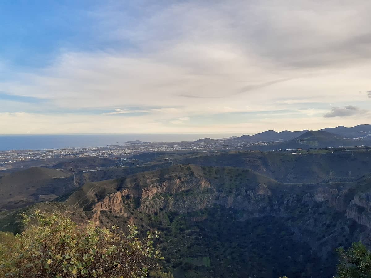
What You're Looking At: The Geology in Plain Terms
The Caldera de Bandama is the most significant example of recent volcanic activity on Gran Canaria. The crater measures about 1,000 metres across and drops around 200 metres to a flat, bowl-shaped floor, with a rim perimeter of roughly three kilometres. This is not an ancient relic buried under millennia of erosion. The landscape here looks geologically fresh: the inner walls are steep and largely bare, dotted with sparse vegetation, and the circular geometry of the crater is still crisp enough to read clearly from the summit.
The peak itself, Pico de Bandama, sits at about 569 metres. From the top, the caldera drops away at your feet while the surrounding landscape opens in every direction. On a clear morning you can trace the ridge of the central massif, pick out the coast near Las Palmas to the north, and on exceptional days see as far as Tenerife across the water to the west. The contrast between the dark volcanic interior and the cultivated terraces on the outer slopes makes for an unusually readable landscape, one that tells the story of the island's geology and agriculture at the same time.
💡 Local tip
Arrive before 10:00 for the clearest air. Cloud build-up over the interior often thickens by midday, especially from October to April, and can reduce visibility significantly.
The Viewpoint Experience: Morning, Midday, and Late Afternoon
The short paved path from the car park to the Mirador Pico de Bandama takes about five minutes on foot. The surface is manageable in ordinary shoes, and the viewpoint platform itself is compact but well-positioned directly above the crater drop. In the early morning, the light rakes across the inner walls at a low angle, throwing the geological layers into sharp relief. The air smells of pine and dry volcanic rock, and the silence is striking given the proximity to Las Palmas, which is around 15 kilometres away.
By late morning, particularly on weekends, cars begin filling the small car park and tour groups arrive with some regularity. The viewpoint platform is not large, so the experience shifts from contemplative to crowded within a short window. If photography is your priority, the low-angle morning light between 08:30 and 10:00 is the most flattering for the crater walls, and you are likely to have the platform largely to yourself.
Late afternoon, from around 16:00 onward, brings softer light from the west and a noticeable drop in visitor numbers. The colours warm up across the scrubland on the crater rim, and if conditions are right, the shadow of the peak stretches east across the caldera floor. This window is underused and worth considering if you are coming by car and have flexibility.
The Crater Rim Walk and the Descent
Beyond the viewpoint, a trail follows the crater rim for a distance. The path is unpaved and uneven in sections, requiring proper footwear and a reasonable level of fitness. The rim walk offers changing angles on the caldera interior and progressively broader views of the surrounding terrain as you move around the circumference. The total perimeter exceeds three kilometres, so a full circuit takes time and some effort.
Descending into the caldera floor is a different matter entirely. A single farmstead sits at the bottom, and the path down is steep and requires physical confidence. Importantly, access to the caldera interior requires a special permit from the Cabildo de Gran Canaria for environmental protection reasons. This is not a casual add-on. If you intend to descend, check current permit requirements with the official Gran Canaria tourism authority before visiting, as the rules are in place to protect the fragile ecosystem of the crater floor.
⚠️ What to skip
Descent into the caldera requires a special permit issued by the Cabildo de Gran Canaria for environmental protection. Do not attempt to enter the crater floor without first verifying current permit requirements through official channels.
If the caldera leaves you wanting more volcanic and archaeological landscape, the Roque Bentayga and Roque Nublo in the island's interior offer a very different kind of geological spectacle, and both are reachable as part of a longer day loop by car.
Historical and Cultural Context
The name Bandama is believed to derive from a Dutch merchant, Daniel van Damme, who cultivated vineyards on the slopes here during the 16th century. The surrounding area, known as the Monte Lentiscal, has a long history of wine production, and the fertile outer slopes of the caldera are still partly given over to agriculture. This overlay of human use on raw volcanic terrain gives Bandama an unusual character: it is simultaneously a geological landmark and a working agricultural landscape.
The caldera is officially recognised as Gran Canaria's most striking example of recent volcanism, and the site sits within a protected natural area. The single farmhouse visible on the caldera floor has been occupied for generations, making Bandama one of the more unusual inhabited craters in the Atlantic islands. That detail alone tends to stop visitors mid-sentence when they spot it from the rim.
For a broader understanding of Gran Canaria's volcanic interior and the communities that developed around it, the Guayadeque Ravine offers a complementary perspective on how islanders have adapted to extreme terrain over centuries.
Getting There and Practical Logistics
By car, Bandama is straightforward to reach from Las Palmas in under 20 minutes. The Carretera de Bandama branches off from the Monte Lentiscal roundabout and climbs directly to the summit area. There is a car park at the top, though it fills quickly on weekend mornings. On weekdays it rarely causes difficulty.
By public transport, Global Bus 311 runs from the San Telmo bus station in Las Palmas toward the Bandama area. Bus fares and timetables on the Global network are subject to change, so confirm current schedules at the Global bus website or at the San Telmo terminal before travelling. The journey takes roughly 30 minutes depending on traffic.
Bandama is well-suited to a half-day trip from Las Palmas, especially if combined with a walk through the nearby Monte Lentiscal or a stop at one of the local wine producers in the area. For a fuller itinerary that incorporates Bandama alongside other inland highlights, the day trips guide for Gran Canaria offers several practical combinations.
Opening Hours, Access, and Accessibility
The viewpoint area is officially listed as open Monday to Friday from 09:30 to 16:30, and Saturday, Sunday, and public holidays from 09:30 to 17:00, though some sources indicate the broader natural area can be accessed until around 22:00. Hours can vary by season. Entry is free. No tickets are sold and no booking is required for the viewpoint or crater rim walk.
Accessibility is limited beyond the immediate viewpoint. The short paved path to the platform is manageable for most visitors, but the crater rim trail and the descent into the caldera are on rough, uneven ground and are not suitable for pushchairs, wheelchairs, or visitors with mobility difficulties. Wear shoes with grip. There are no facilities at the summit, so bring water, particularly in summer when temperatures on the exposed ridge can be significantly warmer than at sea level.
ℹ️ Good to know
There are no cafes, toilets, or shops at the summit viewpoint. Bring water and snacks, and use facilities in Monte Lentiscal or Las Palmas before making the drive up.
Photography Notes
The crater photographs best from the official viewpoint platform in the first two hours after sunrise. The low eastern light defines the layered geology of the inner walls in a way that midday overhead light simply flattens out. A wide-angle lens captures the full sweep of the crater in a single frame; a telephoto or standard zoom lens lets you isolate the farmhouse on the caldera floor and the contrast between cultivated terraces and raw volcanic rock.
Drone use over protected natural areas in Gran Canaria is regulated and may require permits. Do not assume drone flight is permitted at Bandama without first checking current rules with the Cabildo de Gran Canaria or the Spanish aviation authority (AESA).
If landscape photography is central to your trip, pairing Bandama with the Mirador del Balcón on the west coast gives you two very different geological spectacles in a single day by car.
Is Bandama Worth the Trip?
Honestly, yes, with one caveat. If your expectation is a maintained visitor centre, interpretive panels in multiple languages, and a café at the top, you will find Bandama stripped back. There is a viewpoint, a car park, and the crater. The raw quality of the site is precisely what makes it work. For visitors staying in the south of the island at Maspalomas or Playa del Inglés, the drive is around 40 to 50 minutes each way, and should be judged against how much volcanic landscape appeals to you.
Visitors staying in Las Palmas have much less friction getting here. The caldera fits naturally into a morning outing and pairs well with an afternoon in the city's historic Vegueta district or along Las Canteras beach.
Visitors who find unmediated natural landscapes rewarding will leave with a strong impression. The scale of the caldera, read from the rim, is genuinely startling for an island of Gran Canaria's size. Those who prefer attractions with more human infrastructure, guided interpretation, or family facilities may find the experience underwhelming after a long drive.
Insider Tips
- Weekday mornings before 10:00 give you the viewpoint almost entirely to yourself. Weekend afternoons are the most crowded window and the least rewarding for photography.
- The outer slopes of Bandama are wine country. A handful of small bodegas operate in the Monte Lentiscal area below. Ask locally about the Denominación de Origen Gran Canaria wines produced from vines grown on volcanic soil in this exact zone.
- If you want to descend to the caldera floor, research the permit process in advance. Turning up and hoping to walk down without one risks a wasted trip and a fine.
- The bus option via Global 311 from San Telmo is slower but eliminates the parking headache on weekend mornings. Confirm current timetables before you go, as rural routes on Gran Canaria can run infrequently.
- Bring a layer even in summer. The ridge at 574 metres sits above the marine inversion layer and can feel noticeably cooler and windier than the coast. In winter it can be cold enough to need a jacket.
Who Is Bandama Caldera & Crater Viewpoint For?
- Geology and volcanology enthusiasts who want to read a caldera up close
- Photographers seeking dramatic natural landscapes with minimal crowds early in the day
- Day-trippers based in Las Palmas looking for a half-day outing that requires no complex logistics
- Hikers who want to extend beyond the viewpoint along the crater rim trail
- Travellers combining the site with inland Gran Canaria wine country
Nearby Attractions
Combine your visit with:
- Arteara Necropolis
The Arteara Necropolis is the most extensive aboriginal cemetery on Gran Canaria, with 809 stone burial mounds spread across 13 hectares inside the dramatic Barranco de Fataga gorge. It offers a rare, unhurried encounter with the island's pre-Hispanic Canarii people, well away from the resort crowds of the south.
- Barranco de los Cernícalos
Barranco de los Cernícalos is a 7 km round-trip ravine hike in central-eastern Gran Canaria where a year-round stream cuts through laurel forest, fern-draped cliffs, and small waterfalls. It is free to enter, requires no booking, and remains genuinely quiet compared to the island's more promoted highland routes.
- Cactualdea Park
Cactualdea Park sits in the remote western municipality of La Aldea de San Nicolás, where an extraordinary collection of cacti and succulents grows against a backdrop of volcanic rock and Atlantic light. It rewards visitors who make the journey with something genuinely unusual: a curated desert landscape that feels nothing like the resort south of the island.
- Fataga Village
Tucked into the dramatic Barranco de Fataga canyon in southern Gran Canaria, the whitewashed village of Fataga is a free, unhurried stop with real Canarian character. Expect palm-lined lanes, a modest stone church, and views that few visitors from the coastal resorts ever bother to seek out.