Roque Bentayga: Gran Canaria's Ancient Sacred Peak
Rising to 1,404 metres in the volcanic heart of Gran Canaria, Roque Bentayga is a basaltic rock tower surrounded by pre-Hispanic ceremonial sites and sweeping caldera views. The free interpretation centre and trail to the summit plateau make it one of the island's most rewarding inland excursions within the Risco Caído and the Sacred Mountains of Gran Canaria UNESCO cultural landscape.
Quick Facts
- Location
- Finca El Majadal, Tejeda, Gran Canaria (GC-607 from Tejeda, signposted at El Espinillo)
- Getting There
- Car recommended via GC-60 to Tejeda then GC-607; free parking at visitor centre
- Time Needed
- 2–3 hours including interpretation centre and summit trail
- Cost
- Free entry to visitor centre and trail
- Best for
- History enthusiasts, hikers, photographers, and anyone interested in pre-Hispanic Canarian culture
- Official website
- www.viveunescograncanaria.com
What Is Roque Bentayga?
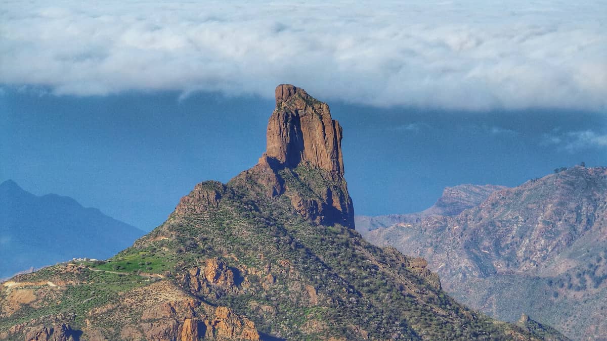
Roque Bentayga is a volcanic basaltic piton, a sheer rock tower thrust up from the floor of the Tejeda caldera, reaching 1,404 metres above sea level. It is one of the most visually striking geological formations in the Canary Islands and, more significantly, one of the most sacred sites in the pre-Hispanic world of the Canarii, the indigenous people of Gran Canaria. Today, together with the broader landscape of caves, granaries, and rock carvings that surround it, Roque Bentayga forms part of the Risco Caído and the Sacred Mountains of Gran Canaria UNESCO World Heritage cultural landscape, inscribed in 2019.
The rock is not just a viewpoint or a geological curiosity. The summit plateau and its immediate flanks contain almogarenes (ritual stone platforms), cave shelters, grain stores carved directly into the rock, and markings that archaeologists believe were used for astronomical observation. The site functioned as a spiritual and administrative centre for communities living across the island's interior centuries before the Spanish conquest in the late 1400s.
The Centro de Interpretación del Roque Bentayga, the official visitor centre at the base of the rock, provides essential context before you attempt the trail. It is well worth spending 30–40 minutes there. Displays are presented in Spanish, English, and German, covering the archaeology of the site, the culture of the Canarii, and the significance of the UNESCO designation. From the centre, a marked trail winds upward to the summit plateau, a round trip of roughly 20–45 minutes depending on your pace and how long you linger at the top. For additional context on the wider mountain landscape, see our guide to Cueva Pintada, another major pre-Hispanic site on the island.
ℹ️ Good to know
The Centro de Interpretación del Roque Bentayga is open from Tuesday to Sunday, typically 10:00–17:00, and closed on Mondays as well as on 1 January, 1 May, and 24, 25, and 31 December. The trail to the rock remains accessible slightly beyond closing time. Admission is completely free.
How the Visit Feels at Different Times of Day
Morning light is unambiguously the best time to be here. In the early hours after opening, the caldera below is often still holding wisps of cloud, and the shadows cast by the rock itself are long and dramatic. The air at this altitude carries a cool, herby scent from the Canarian scrubland, a mix of cistus, retama, and dry earth, and on calm mornings the silence is genuine. You will hear wind, occasionally a raven, and not much else.
By midday, particularly in summer, the sun overhead flattens the landscape visually and the heat at the exposed summit plateau can be intense. There is minimal shade on the upper trail. Families and coach groups tend to arrive mid-morning, so the trail between roughly 11:00 and 13:00 sees its peak foot traffic. If you arrive at 10:00 when the centre opens, you will almost certainly have the first section of the trail to yourself.
Late afternoon is genuinely beautiful for photography, as the low-angle light catches the rock's textured face and the mountains behind Tejeda turn amber and purple. The visitor centre closes at 17:00, but the trail stays open until 18:00, so arriving around 15:30–16:00 gives you time for both. The road back down to Tejeda at dusk, with the caldera in fading light to one side and Roque Nublo looming to the other, is one of those drives that stays with you.
The Trail to the Summit Plateau
The path begins directly behind the visitor centre and is well-marked throughout. The surface is a mix of compacted earth and volcanic rock, with stone steps installed on the steeper sections. Wear shoes with grip: trainers will suffice in dry conditions, but the rock becomes genuinely slippery after rain, which can arrive suddenly in the mountains between November and February.
The ascent is steep enough to require your attention but short enough that it rarely feels punishing. Most reasonably fit visitors reach the plateau in under 25 minutes. The reward is considerable: from the top, you look directly across the caldera to Roque Nublo, which appears dramatically close, while to the south the land drops away toward the warmer, drier valleys leading to the southern coast. On clear days, the island's highest point, the Morro de la Agujereada at 1,956 metres, is visible to the north.
At the summit area, look for the almogarén, a flat stone platform with carved channels believed to have been used in rain-calling rituals. It is one of the best-preserved examples of pre-Hispanic ritual infrastructure in the Canary Islands. The stone is rough phonolite and basalt, and you can hear the wind channelled through the rock faces in a way that feels purposeful, even theatrical. Take your time here. This is the part of the visit that most people rush through on their way back down.
💡 Local tip
Bring at least one litre of water per person. There is no water source on the trail, and the exposed upper sections can be significantly warmer than the car park in summer. A light windproof layer is useful even on sunny days, as gusts at the plateau level can be sharp.
The Interpretation Centre: What to Expect Inside
The Centro de Interpretación del Roque Bentayga is modest in size but substantive in content. It functions less as a museum and more as a contextualising space: the real exhibits are the rock and the landscape outside. Inside, scale models of the site help make sense of the various cave complexes, storage rooms, and ritual areas that are otherwise difficult to mentally map from the trail alone.
Audiovisual presentations explain the astronomical significance of certain rock formations and the broader spiritual geography of the sacred mountain zone. The centre is the starting point for guided visits to Risco Caído, the most archaeologically complex site in the UNESCO area, for which advance booking is required. If you want to go beyond Roque Bentayga and see the painted caves at Risco Caído, check the viveunescograncanaria.com website for availability before your trip, as access is controlled and slots fill quickly in high season.
Getting There: Practical Logistics
Roque Bentayga is in the municipality of Tejeda, in the island's central mountainous interior. A private car or hire car is the only realistic way to reach it independently. The standard route from Las Palmas de Gran Canaria takes roughly 50–60 minutes via the GC-15 toward Cruz de Tejeda, then the GC-60 down into Tejeda and the GC-607 toward Ayacata, with a signed turn-off at El Espinillo around km 19 of the GC-671. From the south coast resorts, approach via Ayacata and the same GC-607.
The car park at the visitor centre is free, surfaced, and has an electric vehicle charging point installed by the Cabildo de Gran Canaria. It is not large, and on busy weekends in spring it fills by mid-morning. There is limited roadside parking on the approach road if needed, but this involves walking an additional 500 metres on an uneven verge.
There is no direct public bus service to the visitor centre. The Global interurban bus network serves Tejeda village, but from there the centre is several kilometres further along the GC-607 with only limited pedestrian infrastructure. If you are without a car, the most practical option is to join an organised excursion from the coast, which several tour operators offer combined with Cruz de Tejeda or Roque Nublo. For context on the broader island road trip, our Gran Canaria road trip guide covers the central mountain circuit in detail.
⚠️ What to skip
The mountain roads to Roque Bentayga are narrow and winding. Drive carefully and pull fully into passing places when meeting oncoming traffic. The GC-607 in particular has sections where two cars cannot pass simultaneously.
Historical and Cultural Context
The Canarii inhabited Gran Canaria for roughly 2,000 years before the Spanish conquest, which was completed in 1483. They were a Berber-origin people with a sophisticated social structure and a rich ceremonial life centred on the island's most dramatic natural features. Roque Bentayga was among the most significant of these: its position at the visual and physical centre of the island's mountain zone, visible from many directions, made it a natural focal point for collective ritual.
The granaries carved into the base of the rock allowed food storage for communities across the caldera region and were likely controlled by the island's ruling class. The almogarén on the summit was used for ceremonies tied to the agricultural calendar, and some researchers believe its orientation captures specific solstice and equinox alignments. The UNESCO World Heritage designation in 2019, which groups Roque Bentayga with Risco Caído and several other sacred mountain sites, recognised not just the physical remains but the entire cultural landscape as a site of outstanding universal value.
For travellers interested in the deeper pre-Hispanic history of Gran Canaria, the Museo Canario in Las Palmas holds the most comprehensive collection of Canarii artefacts on the island and provides excellent background before or after a visit to Roque Bentayga.
Accessibility and Who Should Know Before Going
The visitor centre itself is accessible and air-conditioned, with display materials in multiple languages. However, the trail to the summit plateau is steep, rocky, and involves uneven terrain throughout. It is not suitable for pushchairs, wheelchairs, or visitors with significant mobility impairments. Older visitors or those with joint problems should assess the trail description carefully before committing: the descent, particularly on loose stone sections, requires more care than the ascent.
Children who are comfortable on rough paths and used to short hikes will find the climb exciting rather than difficult. The summit views and the drama of the rock itself tend to land well with younger visitors, particularly those who have been introduced to the island's indigenous history in the interpretation centre first.
Travellers who prefer flat terrain, paved routes, or attractions without physical challenge will find more accessible options nearby. The village of Tejeda itself is worth a slow hour, and Cruz de Tejeda offers panoramic mountain views without any trail walking. If you are planning a full day in the central mountains, both can be combined with Roque Bentayga on a single loop.
Photography Tips
The rock photographs best in the first two hours after opening, when the light comes from the east and rakes across the textured basalt. Morning cloud inversions in the caldera below, which occur most frequently in autumn and winter, can produce extraordinary conditions where the rock appears to float above a sea of white. A wide-angle lens captures the scale effectively from the visitor centre car park; a longer focal length from the summit plateau isolates Roque Nublo and the surrounding peaks.
Avoid harsh midday light in summer for anything other than documentary shots. Late afternoon in the golden hour produces warm tones on the south-facing rock face that are worth the wait. The trail itself is narrow in sections, so a compact camera or mirrorless body is more practical than a full kit with a tripod on the ascent.
Insider Tips
- Combine Roque Bentayga with Cruz de Tejeda and Roque Nublo on the same day. All three are within a short drive of each other by car and together give a complete picture of the central mountain landscape. Start at Roque Bentayga when the centre opens at 10:00, move to Roque Nublo mid-morning, and end at Cruz de Tejeda for lunch.
- If you want to visit Risco Caído, the painted cave complex that forms the other major component of the UNESCO site, book in advance through viveunescograncanaria.com. Access is strictly controlled and cannot be arranged on the day.
- The GC-607 approach road passes through some of the most dramatic caldera scenery on the island. Pull over at the unsigned lay-bys on the descent from El Espinillo for views back toward Roque Bentayga that most visitors never see because they drive straight to the car park.
- The car park fills early on spring Sundays and public holidays. Arriving at 10:00 when the centre opens is reliable. Arriving after 11:30 on a busy day may mean parking on the approach road and adding a 10-minute walk each way.
- Carry a printed or downloaded offline map. Mobile signal is unreliable in the Tejeda caldera, and the GC-607 has no signage errors, but the turn-off at El Espinillo is easy to miss if you are relying on a navigation app that loses signal before the junction.
Who Is Roque Bentayga For?
- History and archaeology enthusiasts who want direct contact with pre-Hispanic Canarian culture in its original landscape
- Hikers looking for a manageable but genuinely rewarding mountain trail with significant archaeological interest at the top
- Photographers seeking dramatic volcanic rock formations, caldera panoramas, and potential cloud inversion shots
- Families with children aged 8 and above who are comfortable on rough paths and engaged by indigenous history
- Travellers on a central mountain day trip combining multiple viewpoints and cultural sites
Nearby Attractions
Other things to see while in Tejeda & the Mountain Interior:
- Cruz de Tejeda
Cruz de Tejeda is the symbolic centrepoint of Gran Canaria, a small mountain hamlet at 1,514 metres where a centuries-old stone cross marks the convergence of the island's main interior roads. The views stretch across volcanic peaks, pine-forested ridges, and ancient calderas — and it costs nothing to visit.
- Pico de las Nieves
At 1,949 metres, Pico de las Nieves is traditionally considered the highest point on Gran Canaria, though recent measurements place nearby Morro de la Agujereada slightly higher. It sits on the border between Tejeda and San Bartolomé de Tirajana. The public viewpoint is free, open around the clock, and offers sweeping mountain panoramas that stretch, on clear days, all the way to the Atlantic horizon and neighbouring islands. Getting there requires a car or a combination of mountain buses, but the reward is a perspective on the island that the beach resorts cannot offer.
- Roque Nublo
Roque Nublo is a volcanic basalt monolith rising from the central highlands of Gran Canaria, one of the most recognizable natural landmarks in the Canary Islands. Visiting the summit via the regulated S-70 trail currently requires advance reservation and a mountain hike, but the panoramic views over the island's interior reward the effort considerably.
- Tamadaba Natural Park
Parque Natural de Tamadaba is Gran Canaria's most significant forested wilderness, a 7,538-hectare protected pine forest draped across the island's rugged northwest. Expect dramatic ridge-top panoramas, silent conifer tracks, and some of the clearest air on the island — all free to enter.