Pico de las Nieves: Gran Canaria's Roof of the World
At 1,949 metres, Pico de las Nieves is traditionally considered the highest point on Gran Canaria, though recent measurements place nearby Morro de la Agujereada slightly higher. It sits on the border between Tejeda and San Bartolomé de Tirajana. The public viewpoint is free, open around the clock, and offers sweeping mountain panoramas that stretch, on clear days, all the way to the Atlantic horizon and neighbouring islands. Getting there requires a car or a combination of mountain buses, but the reward is a perspective on the island that the beach resorts cannot offer.
Quick Facts
- Location
- Between Tejeda and San Bartolomé de Tirajana, central Gran Canaria
- Getting There
- Bus 303 (Las Palmas to San Mateo) + Bus 305 toward Cruz de Tejeda; Bus 18 from Maspalomas toward the central mountains. A rental car is the most practical option.
- Time Needed
- 45 minutes to 2 hours at the viewpoint; allow extra driving time from the coast
- Cost
- Free – public open-air viewpoint with no ticket or gate
- Best for
- Hikers, photographers, road-trippers, clear-day panoramas, stargazing
What Pico de las Nieves Actually Is
Pico de las Nieves stands at around 1,949 metres above sea level and has long been regarded as the highest peak on Gran Canaria, though newer surveys indicate that nearby Morro de la Agujereada is slightly higher. The name translates as "Peak of the Snows," and it is not merely poetic: the summit area was once used to harvest and store winter snow in stone wells, some of which still stand. The official public viewpoint is called the Mirador del Pico de los Pozos de la Nieve, a name referencing those same wells.
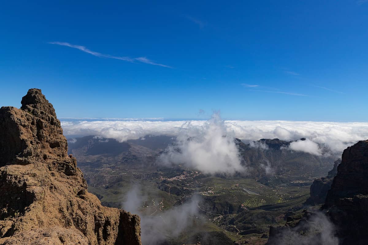
A practical note that catches some visitors off guard: the absolute summit is enclosed within a military installation and is not open to the public. What you access is the adjacent viewpoint area, which sits only marginally lower and gives you everything a traveller actually needs: unobstructed 360-degree views across the central mountain massif, the coast, and on clear days, the silhouettes of Tenerife and La Palma rising from the Atlantic.
ℹ️ Good to know
The viewpoint is free and has no gates or closing times. However, mountain weather here can shift in under 30 minutes. Check conditions before driving up, especially between November and February.
The View and What You Can See
From the viewpoint terrace, the island unfolds in a way that makes its geography suddenly legible. To the north and northwest, the rugged ridgelines of the Tejeda caldera drop away into deep ravines. To the south, the land smoothes and flattens toward the coast and the dune fields of Maspalomas. On the best days, that coastal strip shimmers with a pale haze, and the sea beyond it fades into the horizon.
The two restored snow wells are worth examining up close. They are circular stone structures, dating from the beginning of the 17th century, built to harvest and store winter snow in stone wells, some of which still stand. Winter snow was packed into them, then transported by mule to Las Palmas and the southern towns to preserve food and cool drinks for the wealthy. Seeing them in person, surrounded by open sky and wind-bent pine trees, makes the logistics of that operation genuinely impressive.
The surrounding landscape belongs to the Tamadaba Natural Park zone and shares the character of Gran Canaria's protected central highlands: Canarian pine forest, volcanic rock outcrops, and the kind of silence that is genuinely rare on a popular island. The pines here are adapted to altitude and periodically shrouded in cloud, which gives the forest a different quality to the dry scrubland of the coast.
How the Experience Changes by Time of Day
Sunrise is the most dramatic window. The mountain air at this altitude carries a chill even in summer, so arriving before dawn means temperatures that can feel close to 10 degrees Celsius even when the beach resorts below are already warm. The reward is colour: the eastern ridges catch the first light while the western valleys remain in shadow, and for about 20 minutes the whole landscape has a reddish-gold tone that is difficult to photograph and impossible to forget.
By mid-morning, especially on weekends and in July and August, the viewpoint car park fills quickly. Visitors arrive from the coastal resorts on day excursions, so the peak crowd window tends to be between 10:00 and 13:00. If you arrive after 15:00 on a weekday, you will likely have much more space. The quality of the view in the afternoon depends heavily on cloud: the trade winds push moisture inland from the northeast through the afternoon, and cloud can roll across the summit with very little warning.
Late afternoon and early evening are quieter and often clearer after morning cloud burns off, though this is not guaranteed. Sunset from the summit can be exceptional when the western sky is cloud-free. The site is also designated as one of Gran Canaria's astronomical viewpoints, which means the absence of significant light pollution at this elevation makes it worth considering for night visits, though the road up requires care in the dark.
💡 Local tip
Aim for a weekday morning between September and November. The summer crowds are gone, the air is clearer after the calima (Saharan dust) season, and the autumn light is particularly good for photography.
Getting There: The Honest Version
A rental car is the most practical way to reach Pico de las Nieves. From Las Palmas, the standard route follows the GC-15 toward San Mateo, then continues into the high interior following signs for the central mountains. From Maspalomas and the southern resorts, the GC-1 along the coast leads to inland routes via GC-120 and GC-130. Either approach typically takes about an hour to 90 minutes depending on traffic and your exact starting point. The mountain roads are paved and well-maintained but narrow in places, with steep drops and tight hairpin bends. Drive at a deliberate pace.
Public buses do reach the general area. From Las Palmas, Bus 303 (Global) runs from San Telmo station to San Mateo, where Bus 305 continues toward Tejeda and Cruz de Tejeda. From Maspalomas, Bus 18 heads into the central mountains. However, the final approach to the summit viewpoint involves roads not served by a direct bus stop, so a combination of bus and walking may be needed. This is feasible for fit travellers but requires planning around infrequent timetables. Verify current schedules with Global before attempting the journey by public transport.
Pico de las Nieves is a natural anchor point for a central Gran Canaria road trip. Pair it with a stop at Cruz de Tejeda and a drive through the municipality of Tejeda, where the village itself offers restaurants and a view of Roque Bentayga and Roque Nublo from below.
What to Wear and Bring
The temperature at the summit is often noticeably cooler than at sea level on the same day. In winter, this means near-freezing conditions are possible; in summer, a light jacket is almost always needed. Wind is a near-constant companion at the viewpoint terrace, and it amplifies the cold significantly. Anyone arriving in beachwear will be uncomfortable within minutes.
- Layers: a windproof jacket is more useful than a heavy coat
- Closed shoes: the terrace and surrounding paths involve uneven rock surfaces
- Water and snacks: there are no cafes or vendors at the summit
- Sun protection: UV intensity at altitude is significantly higher than at sea level
- A fully charged phone or camera battery: cold temperatures drain batteries faster
⚠️ What to skip
Cloud cover can reduce visibility to near zero in minutes. If you arrive at the summit and the view is obscured, wait 20 to 30 minutes before leaving: gaps in the cloud often open briefly and can reveal extraordinary scenes.
Photography Notes
The wide panorama here demands a wide-angle lens or a phone's ultra-wide mode. The most composed shots tend to include the snow wells as a foreground element, with the mountain ridges falling away behind them. At sunrise, shooting east gives the best colour; at sunset, face west toward the Atlantic. Midday light flattens everything and makes the landscape look grey in photographs even when it looks impressive to the naked eye.
The summit is one of Gran Canaria's designated astronomical viewpoints, which means clear nights here offer genuinely dark skies. If astrophotography is your interest, the months from May to September offer the best conditions for low humidity and stable air. Bring a tripod, dress warmly, and combine the visit with nearby Roque Nublo for a full day in the island's high-altitude interior.
Who This Suits and Who Might Want to Skip It
Pico de las Nieves works well for travellers who want to understand the island beyond its beaches, for hikers looking to add a summit marker to their itinerary, and for photographers chasing the kind of light and elevation that the coastal resorts simply cannot deliver. Road-trippers will find it a natural high point, both literally and logistically, on any traverse of the island's interior.
It is less suited to visitors who are happy staying in the resort belt and have no particular interest in landscape or geology. If you are travelling with very young children, note that the viewpoint has open terracing at altitude with no barriers in places, and the wind can be strong. Travellers with mobility limitations should know that the paths involve uneven surfaces and steps; wheelchair accessibility is not confirmed in official descriptions. And if the forecast shows heavy cloud for the whole day, it is worth reconsidering: a cloud-covered summit at 1,949 metres is just a cold car park. Check the best conditions for visiting Gran Canaria's interior before committing the drive.
Insider Tips
- The clearest views typically come in the first two hours after sunrise, before the trade-wind clouds build inland from the northeast. Plan your arrival accordingly, especially in summer.
- The military installation at the true summit has radio and radar antennae that are highly visible. For photographs, compose to exclude them by shooting from the lower terrace with the antennae behind you.
- Combine the visit with Cruz de Tejeda, about 10 minutes by road. The parador there serves coffee and the local almond-based sweets (bienmesabe and marzipan), which are a good reason to linger after a cold summit visit.
- If you are driving from Las Palmas and the summit is clouded, sometimes dropping 200 to 300 metres in elevation along the southern slope brings you below the cloud layer and into clear conditions with a view back up to the mist-covered peak.
- The site is part of Gran Canaria's official astronomical viewpoint network. Local astronomy clubs occasionally organise events here; check the Gran Canaria tourism board website for scheduled stargazing evenings.
Who Is Pico de las Nieves For?
- Hikers and trekkers wanting Gran Canaria's highest accessible point
- Photographers chasing altitude light and 360-degree panoramas
- Road-trippers on a central island loop
- Travellers curious about the island's pre-tourism history and landscape
- Stargazers and astrophotographers seeking dark-sky conditions
Nearby Attractions
Other things to see while in Tejeda & the Mountain Interior:
- Cruz de Tejeda
Cruz de Tejeda is the symbolic centrepoint of Gran Canaria, a small mountain hamlet at 1,514 metres where a centuries-old stone cross marks the convergence of the island's main interior roads. The views stretch across volcanic peaks, pine-forested ridges, and ancient calderas — and it costs nothing to visit.
- Roque Bentayga
Rising to 1,404 metres in the volcanic heart of Gran Canaria, Roque Bentayga is a basaltic rock tower surrounded by pre-Hispanic ceremonial sites and sweeping caldera views. The free interpretation centre and trail to the summit plateau make it one of the island's most rewarding inland excursions within the Risco Caído and the Sacred Mountains of Gran Canaria UNESCO cultural landscape.
- Roque Nublo
Roque Nublo is a volcanic basalt monolith rising from the central highlands of Gran Canaria, one of the most recognizable natural landmarks in the Canary Islands. Visiting the summit via the regulated S-70 trail currently requires advance reservation and a mountain hike, but the panoramic views over the island's interior reward the effort considerably.
- Tamadaba Natural Park
Parque Natural de Tamadaba is Gran Canaria's most significant forested wilderness, a 7,538-hectare protected pine forest draped across the island's rugged northwest. Expect dramatic ridge-top panoramas, silent conifer tracks, and some of the clearest air on the island — all free to enter.