Lisbon Map: Neighborhoods, Landmarks & How to Navigate the City
Lisbon covers just 100.05 km² but packs in dramatically different neighborhoods, from medieval hilltop alleys to modern riverside parks. This guide breaks down the Lisbon map by district, explains how far apart things really are, and tells you the smartest ways to get between them.
Plan and book this trip
Tools from our partner Travelpayouts help you compare flights and hotels. If you book through them, we may earn a commission at no extra cost to you.
Flights
Hotels map
TL;DR
- Lisbon (Lisboa) is Portugal's capital, sitting on the northern shore of the Tagus River at roughly 38.7°N, 9.1°W.
- The city divides into distinct clusters: historic Alfama and Baixa in the centre, elegant Chiado and Príncipe Real to the west, monumental Belém further west, and modern Parque das Nações to the east near the airport. See our complete things to do in Lisbon guide for what each area offers.
- Not everything is walkable. Belém is 6 km from Baixa; use Tram 15E or the train from Cais do Sodré. Parque das Nações is 10 km east; take the Red Metro line.
- The city runs on Western European Time: UTC+0 in winter, UTC+1 (WEST) from late March to late October.
- Summer crowds concentrate in Alfama and Baixa from June to August. For timing advice, see when to visit Lisbon.
Lisbon at a Glance: City Basics
Lisbon is the capital and largest city of Portugal, home to around 545,796 people within the city limits and roughly 3 million in the greater metropolitan area. The city proper covers just 100.05 km² (38.6 square miles), which sounds compact until you realize how much terrain is packed into it. Seven hills, a wide river estuary, and centuries of urban sprawl in every direction make spatial orientation genuinely tricky for first-time visitors.
The city sits on the north bank of the Tagus River (Tejo in Portuguese), where it meets the Atlantic. This geography shapes everything: the historic core hugs the riverfront, Belém stretches west along the water, and the modern waterfront at Parque das Nações extends east. A quick look at a Lisbon Portugal map reveals that most tourist landmarks line up along this river axis rather than spreading evenly across the city.
ℹ️ Good to know
Lisbon operates on Western European Time (WET, UTC+0) from late October to late March, and Western European Summer Time (WEST, UTC+1) from late March to late October. If you're booking day trips or transport from abroad, factor this in when checking timetables.
The Lisbon Neighborhood Map: Where Things Actually Are

Lisbon has 24 official freguesias (parishes), but for navigation purposes, most visitors only need to understand seven or eight distinct zones. Each has its own character, elevation, and transport logic. Treating the city as one walkable block is the single biggest planning mistake tourists make.
- Baixa & Chiado The reconstructed grid at river level, rebuilt after the catastrophic 1755 earthquake. Baixa is all broad pedestrian streets, banks, and souvenir shops. Chiado, just uphill, shifts to independent bookshops, concept stores, and café culture. These two areas bleed into each other and form the true commercial and social centre.
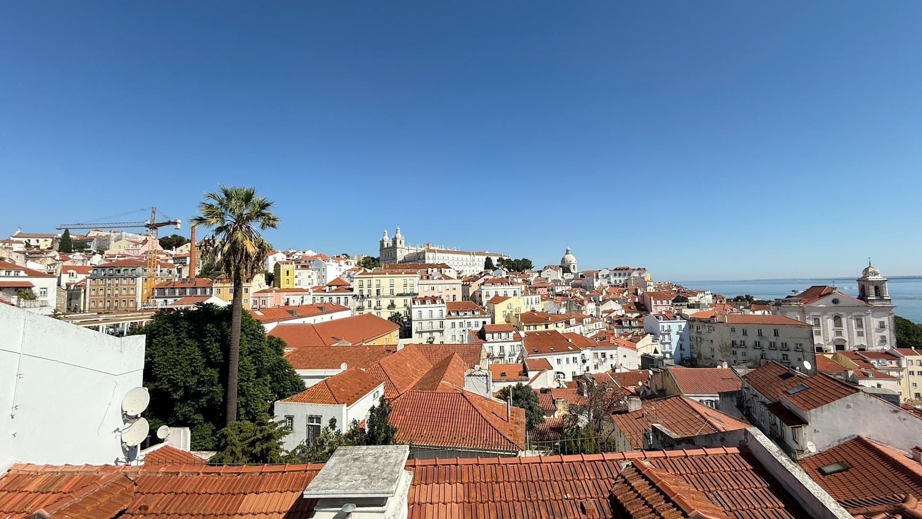
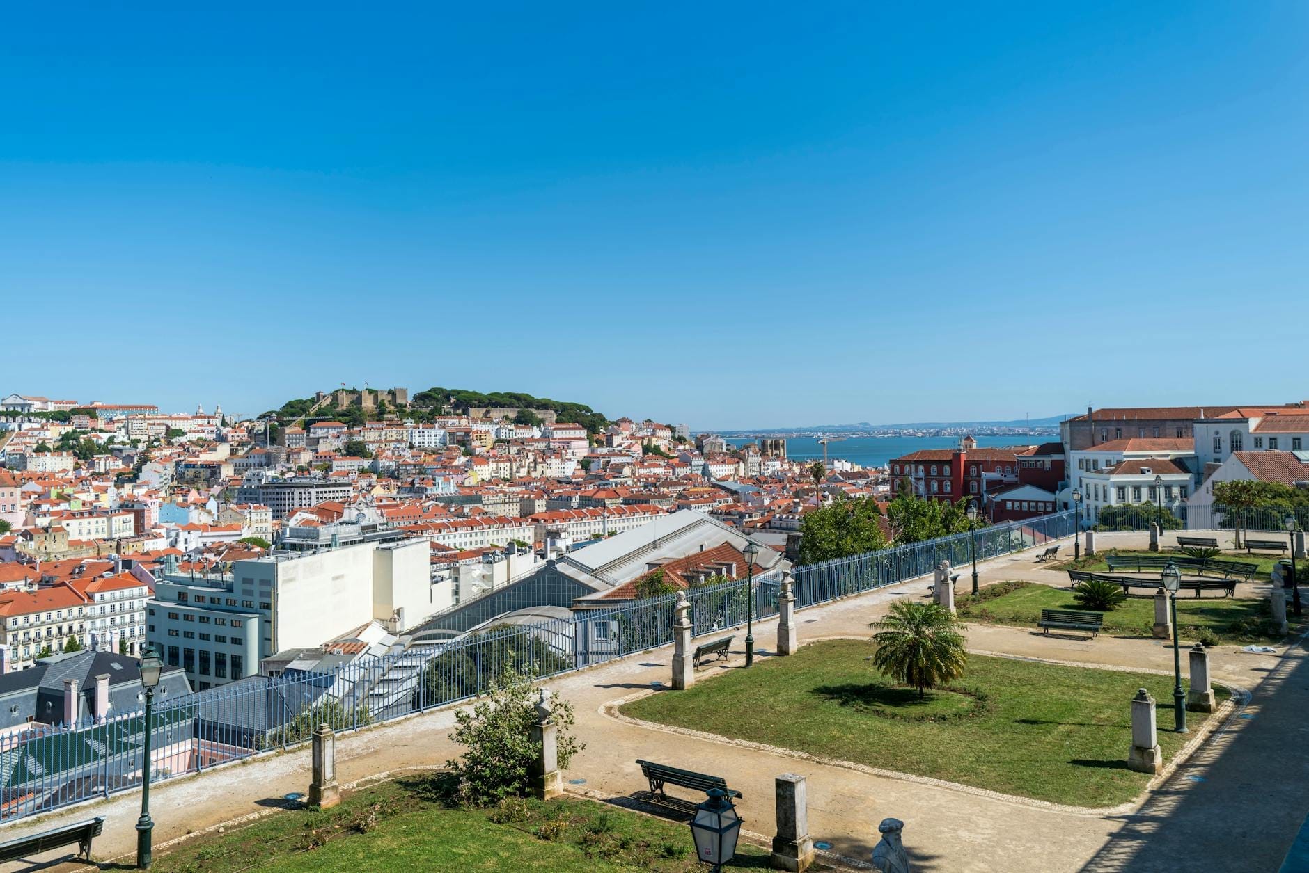
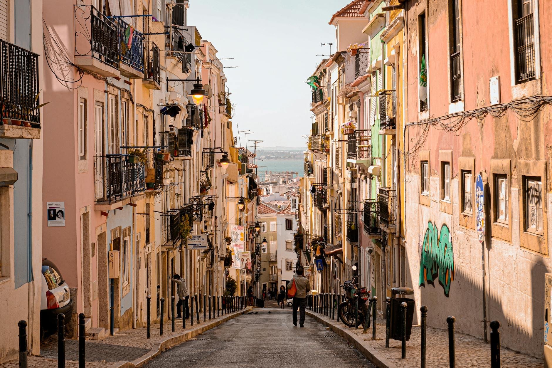
- Alfama Lisbon's oldest surviving quarter, east of Baixa, climbing steeply up toward São Jorge Castle. Narrow lanes, fado venues, and some of the best miradouros (viewpoints) in the city. Expect cobblestones, steep inclines, and limited car access. Mornings are quiet; evenings draw large crowds.
- Bairro Alto & Príncipe Real Uphill from Chiado, Bairro Alto is the city's nightlife axis. Príncipe Real, just north, is calmer, with antique dealers, a Sunday market, and one of the city's best gardens. Both sit on the same elevated ridge and are easy to walk between.
- Graça & Mouraria North and northeast of Alfama, these are among Lisbon's most authentically local neighborhoods. Graça has excellent viewpoints and fewer tourist crowds. Mouraria is the city's historic Moorish quarter, now a multicultural area around the base of the castle hill.
- Belém A separate cluster 6 km west of Baixa along the riverside. This is where Lisbon's Age of Discovery monuments concentrate: Jerónimos Monastery, Belém Tower, the Monument to the Discoveries, and the coach museum. Not walkable from the centre — plan a dedicated half-day trip.
- Santos & Cais do Sodré Just west of Baixa on the riverfront, this area includes the Time Out Market, the Pink Street nightlife strip, and the main ferry terminal for crossings to the south bank. Increasingly popular with younger visitors.
- Parque das Nações Built for Expo 98, this modern district sits 10 km east of the historic centre near Lisbon Airport. Wide riverside promenades, the Oceanarium, the Vasco da Gama Tower, and contemporary architecture. Completely different in feel from the rest of the city.
⚠️ What to skip
A Lisbon neighborhood map can be misleading at first glance. Belém looks close to Baixa on a city-wide map, but it takes 20-30 minutes by tram or train. Parque das Nações looks closer than it is on a metro schematic. Always check actual travel times, not just map distances.
Key Landmarks and Where to Find Them

The city's most iconic landmarks cluster around two poles. In the historic centre: São Jorge Castle crowns the Alfama hill, the Sé Cathedral sits at its foot, and Praça do Comércio opens onto the river at the base of Baixa. In Belém: the Jerónimos Monastery and Belém Tower are within 1 km of each other and easy to combine in a single visit.
For elevated city views, the best miradouros are spread across different hills. Miradouro da Graça and Miradouro da Senhora do Monte offer the widest panoramas and see far fewer visitors than the more famous spots in Alfama. If you want a full rundown of the best vantage points across the city, the guide to Lisbon's viewpoints covers all of them with practical access notes.
A few landmarks that appear on every tourist map are genuinely worth seeking out, and a few are overrated. The Santa Justa Elevator (Elevador de Santa Justa) is beautiful engineering but the queues are long and the view from the top is only marginally better than the free street-level view from Largo do Carmo just above it. Tram 28E is a legitimate way to traverse Alfama's hills, but in summer it runs at near-capacity with tourists; using it purely for transport is frustrating. If you want to ride it for the experience, go before 9am.
How to Navigate Lisbon: Transport by Zone

Lisbon's terrain makes flat-map navigation unreliable. The city rises sharply from the river, and a route that looks straightforward on a map may involve a 60-metre climb on cobblestones. Understanding which transport mode fits which journey saves significant time and frustration.
- Metro (Metropolitano de Lisboa) Four lines (Blue, Yellow, Green, Red) cover the main corridors. The Red Line connects the airport to the city centre in about 20 minutes for around €1.60. The Green and Blue lines link Baixa, Chiado, Rossio, Marquês de Pombal, and Parque das Nações. Metro is the fastest option for longer cross-city journeys and runs from around 6:30am to 1am.
- Tram 15E to Belém The most practical tram for visitors. Runs from Praça da Figueira in Baixa west along the river to Belém, stopping near the monastery and tower. Journey time is 20-30 minutes depending on traffic. The Carris day pass (around €6-7, verify current pricing at carris.pt) covers this route.
- Train from Cais do Sodré Cascais Line trains from Cais do Sodré station are the best option for reaching Belém (Belém station, 10 min) and the Atlantic beaches further west. Trains run frequently, are rarely crowded outside peak commute hours, and the Belém stop is closer to the main sites than the tram stop.
- Ferries from Cais do Sodré Transtejo ferries cross the Tagus to Cacilhas on the south bank, offering views of the Cristo Rei statue. The 10-minute crossing costs around €1.40. Useful for day trippers who want a different angle on the Lisbon Portugal cityscape from the water.
- Walking within districts Baixa, Chiado, and the lower parts of Alfama are walkable to each other. But going uphill in Alfama or Bairro Alto on a hot day is genuinely tiring. The funiculars (Glória, Bica, Lavra) and the Santa Justa Elevator reduce elevation gain on the most common routes.
✨ Pro tip
Download the Google Maps or CityMapper app before arriving and save an offline Lisbon map. Mobile data is reliable across the city, but having the map cached helps when you're navigating underground metro stations. The official Carris app shows real-time tram and bus positions, which matters when Tram 28E is running late.
Lisbon Weather and When It Affects Navigation
Lisbon has a Mediterranean climate: warm, dry summers and mild, wet winters. This directly affects how you experience the city on foot. For a full seasonal breakdown, see the Lisbon weather guide. For planning purposes: summer (June to August) means 25-30°C heat that makes the uphill climbs in Alfama and Graça genuinely exhausting by midday. Winter (December to February) averages 12-16°C, which is comfortable for walking but brings regular rain.
Crowd patterns follow the weather closely. July and August are peak season for Baixa, Alfama, and Belém. Viewpoints in Alfama can feel overwhelming in summer afternoons. If you visit between May and June or September and October, you get near-summer temperatures (15-22°C) with noticeably thinner crowds at every major site. Winter navigation has its own advantage: trams run on schedule, viewpoints are often empty, and you can actually hear the fado drifting from a restaurant doorway without competing with tour group noise.
Practical City Facts for First-Time Visitors
A few basic facts that matter before you open any map app. Lisbon uses the Euro (EUR). Tap water is safe to drink throughout the city. English is widely spoken in tourist areas, though learning a few words of Portuguese is appreciated. The emergency number is 112. Portugal's country dialing code is +351. Type F (Schuko) plugs are standard at 230V, the same as most of continental Europe.
Lisbon Airport (IATA: LIS) is 10 km from the city centre, served by the Red Metro line. Journey time to Baixa-Chiado is roughly 20-25 minutes. Taxis and Uber/Bolt cost around €15-20 depending on traffic. The airport sits close to Parque das Nações on the eastern edge of the city, which is worth noting if you arrive late and want to stay near the airport for a first night. The Lisbon airport guide covers all arrival logistics in detail.
- Visa-free entry (90 days) for EU, US, Canadian, and Australian passport holders. EU visitors should check ETIAS requirements as rules may update.
- Tipping is not obligatory but 5-10% in restaurants is appreciated if service charge is not already included.
- Most major museums cluster in three areas: Belém (coach museum, Berardo Collection, MAAT), Alfama/Mouraria (National Tile Museum, Fado Museum), and the Gulbenkian campus north of Marquês de Pombal.
- Lisbon has 24 oficial freguesias but the main tourist zones concentrate in roughly 6-8 of them.
- The Viva Viagem card (reloadable smart card, around €0.50) works across metro, trams, buses, and some ferry routes — far cheaper than buying single tickets.
💡 Local tip
If you are planning to visit multiple paid attractions, look into the Lisboa Card, which covers unlimited public transport and free or discounted entry to over 30 museums and monuments. It is available in 24, 48, or 72-hour versions from the airport, main tourist offices, and online. Run the numbers against your actual itinerary before buying — it only saves money if you are doing at least 3-4 paid attractions per day.
FAQ
What time zone is Lisbon, Portugal in?
Lisbon runs on Western European Time (WET, UTC+0) from late October to late March, and Western European Summer Time (WEST, UTC+1) from late March to late October. This means Lisbon is 1 hour behind most of continental Europe in summer and aligned with the UK, and 1 hour ahead of the UK in winter.
What are the main neighborhoods on a Lisbon map?
The key tourist neighborhoods are Baixa and Chiado (city centre, flat and walkable), Alfama (oldest hilltop district, east of centre), Bairro Alto and Príncipe Real (uphill west of Chiado), Graça and Mouraria (north and northeast, more local), Belém (6 km west, monumental riverfront zone), Santos and Cais do Sodré (nightlife and ferries), and Parque das Nações (modern district near the airport, 10 km east).
Is Lisbon easy to navigate without a car?
Yes, for most itineraries. The metro, trams, buses, and trains cover all major tourist areas. Walking works well within individual neighborhoods, but the city's hills and the distances between zones like Belém and Parque das Nações make public transport essential. Uber and Bolt are widely available and reasonably priced as backup options.
How far is Belém from central Lisbon?
Belém is about 6 km west of Praça do Comércio. By Tram 15E it takes 20-30 minutes from Praça da Figueira. The Cascais Line train from Cais do Sodré station reaches Belém station in approximately 10 minutes. Walking is possible along the riverside path but takes around 1 hour and is best done on a cool day.
What is the weather in Lisbon, Portugal like throughout the year?
Lisbon has a Mediterranean climate. Summers (June to August) are hot and dry, averaging 25-30°C. Winters (December to February) are mild and rainy, averaging 12-16°C. Spring (March to May) and autumn (September to November) offer the best combination of comfortable temperatures, roughly 15-23°C, and moderate crowds. Rain is most likely between October and April.