Mount Tamalpais State Park: The Peak That Puts San Francisco in Perspective
Rising 2,571 feet above Marin County, Mount Tamalpais State Park delivers sweeping views of the Bay, the Pacific, and the city skyline across 6,300 acres of redwood groves and oak woodland. It's one of the most rewarding day trips from San Francisco, but only if you plan around the weather.
Quick Facts
- Location
- 801 Panoramic Highway, Mill Valley, CA 94941 — Marin County, north of the Golden Gate Bridge
- Getting There
- Car recommended via US-101 to Mill Valley, then Panoramic Highway. Limited transit via Marin Transit and seasonal Golden Gate Transit buses — check current schedules
- Time Needed
- 3–5 hours for a typical summit hike and exploration; a full day if you add multiple trails
- Cost
- Day-use vehicle parking about USD $8 at designated lots such as East Peak, Pantoll, and Bootjack (verify current amount at parks.ca.gov or onsite). Hiking itself is free.
- Best for
- Hikers, photographers, anyone wanting panoramic Bay Area views without crowds
- Official website
- www.parks.ca.gov/?page_id=471
What Mount Tamalpais Actually Is
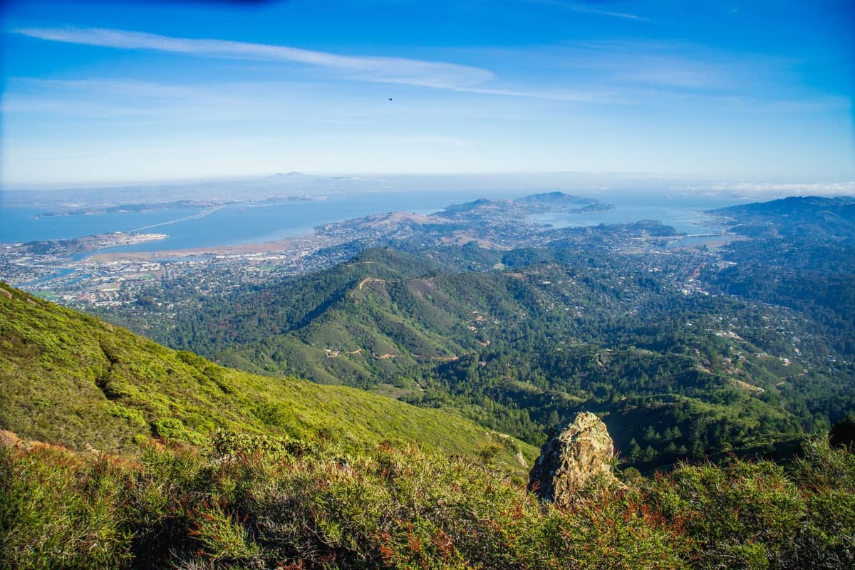
Mount Tamalpais State Park is a California state park covering approximately 6,300 acres of protected coastal mountain terrain in Marin County, roughly 15 miles north of San Francisco. The summit of Mount Tamalpais, known locally as Mount Tam, reaches 2,571 feet (784 meters) above sea level. On a clear day from the East Peak, you can see the Golden Gate Bridge, the Bay Bridge, the San Francisco skyline, and beyond to the Sierra Nevada. On a foggy day, you see a white ocean of cloud below you and blue sky above, which is arguably more dramatic.
The mountain carries deep historical weight. The indigenous Coast Miwok people inhabited these lands for thousands of years, and the name Tamalpais derives from their language. Spanish explorers in 1770 recorded the mountain as "La Sierra de Nuestro Padre de San Francisco" before it reverted to the Miwok name. Today, the park sits at the intersection of redwood canyon, chaparral ridge, and open grassland, and the transitions between those habitats as you climb are one of the more quietly striking things about the place.
ℹ️ Good to know
The park is generally open daily from 7:00 a.m. to sunset for developed areas and parking lots. Cars parked after hours are subject to fines. The East Peak Visitor Center and Gravity Car Barn Museum are generally open weekends 12:00 p.m.–4:00 p.m., staffed by volunteers, and hours can change — call (415) 388-2070 to confirm before visiting.
How the Experience Changes Through the Day
Arriving at 7:30 a.m. on a weekday puts you on the trail before the parking lots fill. The air at that hour carries the sharp resin smell of Douglas fir and a cold dampness that clings to your jacket until the sun clears the eastern ridge. The trails are quiet enough that you hear birds clearly and occasionally catch the rustling of deer in the brush below the trail edge. The light is low and directional, which makes the coastal hills to the west look textured and three-dimensional.
By late morning, the lots at Pantoll Ranger Station fill on weekends. Families with young children tend to concentrate on the shorter loop trails near the Pantoll area. Serious hikers press on toward East Peak. By noon on summer days, the marine layer frequently burns off and the views from the summit sharpen considerably, though the wind picks up substantially at the exposed East Peak overlook. Bring a layer you can pull on at the top, even in August.
Afternoon visits can work well in autumn, when September and October typically bring the clearest skies in the Bay Area and the best chance of unobstructed views from the summit. Summer afternoons are often windy and can re-fog quickly. Winter visits after heavy rain offer the clearest air and the greenest hillsides, but trail conditions can be muddy and some access roads may be temporarily closed.
Tickets & tours
Hand-picked options from our booking partner. Prices are indicative; availability and final rates are confirmed when you complete your booking.
Sonoma and Napa Valley wine tour from San Francisco
From 127 €Instant confirmationFree cancellationGo City | San Francisco Explorer Pass
From 76 €Instant confirmationFree cancellationMuir Woods and Sausalito guided tour with transportation
From 82 €Instant confirmationFree cancellationSan Francisco CityPASS
From 77 €Instant confirmationFree cancellation
Getting There from San Francisco
The most straightforward route by car is the Golden Gate Bridge to US-101 North, exit at Mill Valley/Stinson Beach, then follow California Route 1 and Panoramic Highway up the mountain. The drive from downtown San Francisco takes roughly 40 to 50 minutes without traffic. The road is narrow and winding above the lower slopes, with no guardrails in sections, which surprises first-time visitors. Drive at the posted speeds and pull over for oncoming vehicles at the wider sections.
Public transit access requires planning. Marin Transit and Golden Gate Transit serve the Mill Valley area, and the Marin Transit Route 61 ‘Muir Woods Shuttle’ runs on weekends and holidays toward trailheads like Pantoll Ranger Station, but service is limited and schedules change seasonally. Verify current routes and timetables before relying on transit. For context on the broader transport options around San Francisco, the getting around San Francisco guide covers Bay Area transit fundamentals.
⚠️ What to skip
Parking at the main lots — especially Pantoll and East Peak — fills by 9:00 a.m. on clear weekend mornings. If you arrive after 10:00 a.m. on a busy day, you may be directed to overflow parking and face a longer walk. Arriving before 8:00 a.m. reliably solves this problem.
The Trails: A Practical Walkthrough
The park contains over 50 miles of trails across varying difficulty levels. The main hiking zones center on three areas: the Pantoll Ranger Station, the East Peak summit area, and the Steep Ravine trail corridor, which descends toward the coast. Each feels markedly different from the others.
The Steep Ravine Trail is the most sensory experience on the mountain. The path drops into a redwood canyon where the temperature falls noticeably, moisture clings to the bark of large coast redwoods, and wooden ladders cross sections of wet rock. It connects to the coast below, where Stinson Beach sits at the foot of the mountain. The round trip from Pantoll is strenuous and should be approached with proper footwear.
The route to East Peak follows a mix of fire roads and single-track trails. The upper section is exposed chaparral with low scrub, manzanita, and sweeping views before the final approach to the summit. The East Peak Fire Lookout Tower dates from the 1930s and is a Civilian Conservation Corps structure, giving the summit a spare, historic quality beyond the views. On clear days, the panorama encompasses the entire Bay Area from Marin to the South Bay.
If you're approaching Mount Tam as part of a broader Marin County day, it pairs naturally with a visit to the redwood cathedral of Muir Woods, located in the western drainages of the same mountain, or the coastal terrain of the Marin Headlands just south of the park boundary.
Photography and Views
The East Peak overlook is the most photographed spot in the park. The composition looking south captures the Golden Gate strait, often with the bridge partially in fog, the San Francisco skyline to the right, and the Bay extending eastward toward Oakland and Berkeley. For the best light, morning visits face east and catch the city in warm early sun. Afternoon visits from the western ridge face into the Pacific light, which flattens at midday and turns golden after 4:00 p.m.
The views from Mount Tam are often compared to those from Twin Peaks inside the city, but they operate at a completely different scale. From Twin Peaks, you look across the city. From Mount Tam, you look across the entire Bay Area, with the city as one element in a wider landscape. The sense of elevation and distance is substantially greater.
💡 Local tip
For the classic fog-sea-below-and-city-beyond photograph, visit in June or July on a morning when fog fills the Bay by 8:00 a.m. The summit typically sits above the marine layer, and from East Peak you can watch the fog pour through the Golden Gate in near silence.
What to Bring and Accessibility Notes
Layers are not optional. Even on warm Bay Area days, the summit can be 15 to 20 degrees cooler than San Francisco, and the wind at East Peak is persistent and cold. Bring a wind shell at minimum. Wear trail shoes or hiking boots with grip, especially for the Steep Ravine section where wet rock and wooden ladders require traction. Carry water, as there are limited refill points on the trails.
Accessibility at the park is limited by the terrain. California State Parks maintains an Accessible Features page for Mount Tamalpais with details on accessible parking spots, restrooms, and which trail segments are paved or surfaced for wheelchair access near the Pantoll area. Visitors with specific accessibility needs are encouraged to call (415) 388-2070 or contact the Pantoll Visitor Services Kiosk ahead of arrival.
Families considering the park with younger children should note that most summit trails involve significant elevation gain and uneven terrain. Easier terrain with a more structured experience can be found at Golden Gate Park inside the city, or on the gentler trails at Crissy Field along the waterfront. The San Francisco with kids guide covers family-appropriate outdoor options in more detail.
Is It Worth the Trip?
Mount Tamalpais State Park is worth the trip for anyone who hikes, wants to understand the Bay Area's geography from above, or simply wants a full day outside the city. It is not overhyped — the views are among the best in Northern California, and the combination of redwood canyon, open ridge, and coastal outlook in a single park is unusual.
The case against going: it requires a car or significant transit planning, the summit trails are strenuous, and summer weekends can make the parking situation frustrating enough to undercut the experience. If you have limited time in San Francisco and do not hike regularly, the park may be more logistically demanding than the reward justifies. For those visitors, a closer viewpoint like Twin Peaks or the Marin Headlands provides a partial substitute with lower friction.
Insider Tips
- The Gravity Car Barn Museum near East Peak is a small but interesting exhibit about the gravity-powered railway that carried passengers up the mountain from 1896 to 1930. It's staffed by volunteers on weekends, is free, and takes about 20 minutes. Most visitors walk past it without stopping.
- If the East Peak lot is full, park at the Pantoll Ranger Station and hike up the Old Mine Trail. The walk adds roughly 1.5 miles and 700 feet of elevation, but it passes through a redwood grove and chaparral section that most drive-to-summit visitors miss entirely.
- Cell coverage is unreliable on the upper mountain. Download a trail map from AllTrails or the California State Parks website before you leave San Francisco. The trail junctions are well-signed, but having an offline map prevents confusion on longer routes.
- The Pantoll Ranger Station has a small water fountain and restrooms that are generally accessible during staffed hours. It's the last reliable water point before the summit. Fill your bottles here.
- Autumn visits, particularly late September through November, consistently offer the clearest views. The rainy season has not yet begun, temperatures are mild, summer crowds have thinned, and the hillside grasses take on a gold-brown color that makes the landscape look completely different from its spring green.
Who Is Mount Tamalpais State Park For?
- Hikers looking for a technically accessible but rewarding summit experience within an hour of San Francisco
- Photographers wanting the wide Bay Area panorama shot from above the fog line
- Travelers with a full day to spare who want to understand the Bay Area's landscape beyond the city limits
- Anyone who wants to combine a summit hike with a visit to Muir Woods or the Marin Headlands in a single day trip
- Visitors in autumn seeking clear skies and uncrowded trails after peak summer season
Nearby Attractions
Combine your visit with:
- 16th Avenue Tiled Steps
The 16th Avenue Tiled Steps Project is a community-made mosaic staircase of 163 steps stretching through San Francisco's Golden Gate Heights neighborhood (a sub-area of the Inner Sunset), depicting a journey from the ocean floor to the night sky. It's free, photogenic, and connects to one of the city's best lesser-known hilltop viewpoints.
- Angel Island State Park
Angel Island State Park sits in the middle of San Francisco Bay, offering miles of hiking trails, layers of military and immigration history, and 360-degree views of the city skyline, Marin headlands, and beyond. Getting there requires a ferry, which is part of the appeal — the island feels removed from city life, even though San Francisco is visible the entire time.
- Asian Art Museum of San Francisco
One of the largest Asian art collections in the Western world, housed in a transformed Beaux-Arts landmark at Civic Center. From ancient Chinese bronzes to contemporary Southeast Asian installations, the museum rewards careful visitors who know what to look for.
- UC Berkeley Campus
The University of California, Berkeley sits on a hillside above San Francisco Bay, offering free access to striking Beaux-Arts architecture, landmark museums, and open green spaces. A short BART ride from San Francisco, it rewards curious visitors with history, intellectual energy, and some of the best campus scenery in the country.