Marin Headlands: The Wild Coast Right Across the Golden Gate
The Marin Headlands offer some of the most dramatic coastal scenery in Northern California, perched just north of the Golden Gate Bridge. Part of the Golden Gate National Recreation Area, this free, NPS-managed wilderness rewards visitors with sweeping bay views, rugged hiking trails, historic military bunkers, and a quieter, wilder alternative to the city crowds.
Quick Facts
- Location
- Marin County, CA — accessed via Conzelman Road just north of the Golden Gate Bridge
- Getting There
- Limited public transit; Golden Gate Transit buses serve the Golden Gate Bridge Toll Plaza and Sausalito nearby. Most visitors drive or bike across the Golden Gate Bridge.
- Time Needed
- 2–5 hours for a focused visit; full day if hiking multiple trails
- Cost
- Free general entry (part of Golden Gate National Recreation Area). Some specific sites may require reservations.
- Best for
- Hikers, photographers, cyclists, and anyone wanting an escape from the city within 30 minutes
- Official website
- www.nps.gov/goga/marin-headlands.htm
What the Marin Headlands Actually Are
The Marin Headlands form a rugged stretch of coastal hills on the southern tip of Marin County, separated from San Francisco only by the width of the Golden Gate strait. Managed by the National Park Service as part of the Golden Gate National Recreation Area since 1972, this is not a manicured park with paved paths and refreshment stands. It is open, windswept terrain: steep grassy ridges, crumbling concrete military installations from three different eras, sea-battered rocky coves, and unobstructed views stretching from the Farallon Islands to the Bay Bridge.
The area covers thousands of acres and contains multiple distinct destinations, including Hawk Hill, Rodeo Beach, the Point Bonita Lighthouse, and the Marine Mammal Center. No single address captures all of it. Most visitors enter from the Marin side of the Golden Gate Bridge and navigate Conzelman Road, a two-lane route that climbs the western ridge before dropping toward Rodeo Lagoon and the valley beyond.
ℹ️ Good to know
General entry to the Marin Headlands is free and the area is generally open 24 hours. Some specific facilities and parking areas close at dusk or have seasonal access restrictions. Point Bonita Lighthouse has limited visiting hours and periodic closures — check the NPS website before making it the centerpiece of your trip.
The Golden Gate View: Why Hawk Hill Earns Its Reputation
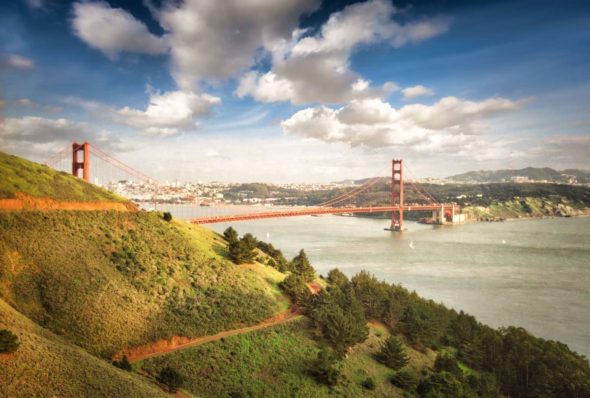
The overlooks along Conzelman Road, especially the Battery Spencer and Hawk Hill areas, deliver the view that photographers travel across the world to capture: the Golden Gate Bridge from above and behind, with the San Francisco skyline arranged in the background and the Pacific opening beyond the bridge's western tower. From street level in the city, you are always looking up at the bridge or standing on it. From here, you look down on it, and the scale of the structure becomes surprising.
The experience is dramatically affected by weather and time of day. On a clear morning in September or October — statistically the warmest and clearest months in this part of California — the light falls directly onto the bridge's International Orange paint and the views are sharp for miles. On a June afternoon, the marine fog layer often pours through the Golden Gate at eye level, which creates an equally striking image but a very different one. For more context on how fog shapes the city's atmosphere, see our best time to visit San Francisco guide.
Sunrise visits are exceptional but require careful planning. The first light hits the eastern face of the headlands and the bay, while the bridge catches color early. By 8 a.m. on a weekday, the Conzelman Road overlooks hold only a few other visitors. By 10 a.m. on a Saturday in summer, the main Battery Spencer pullout can have a dozen cars and a persistent wind that makes a fleece jacket less optional than it seems.
💡 Local tip
Bring at least one more layer than you think you need. The headlands sit directly in the path of Pacific winds, and the temperature at the ridgeline can feel 10–15°F colder than downtown San Francisco. A windproof shell is more useful here than a heavy sweater.
Tickets & tours
Hand-picked options from our booking partner. Prices are indicative; availability and final rates are confirmed when you complete your booking.
Sonoma and Napa Valley wine tour from San Francisco
From 127 €Instant confirmationFree cancellationGo City | San Francisco Explorer Pass
From 76 €Instant confirmationFree cancellationMuir Woods and Sausalito guided tour with transportation
From 82 €Instant confirmationFree cancellationSan Francisco CityPASS
From 77 €Instant confirmationFree cancellation
Hiking the Headlands: What the Trails Actually Feel Like
The Marin Headlands trail network ranges from short paved walks to full-day ridge routes. The Coastal Trail segment near Rodeo Beach offers the most dramatic coastal experience: a narrow dirt path that traces the cliff edge above sea stacks and kelp-darkened coves. The sound down here is constant — waves breaking against the rock below, the occasional bark of a harbor seal, the rustle of coastal scrub. The vegetation is low and wind-shaped, mostly coyote brush and California sage, which releases a sharp medicinal smell when the trail brushes against it.
The Rodeo Beach trailhead is one of the most accessible starting points. The beach itself is distinctive: instead of sand, it is covered in smooth gray and green pebbles of chert and serpentine, rounded by centuries of wave action. These rocks are geologically significant — the Marin Headlands contain some of the most well-studied examples of Franciscan Complex geology in California, with oceanic crustal rocks that were scraped off the Pacific Plate and accreted onto North America over millions of years. It is a different kind of landscape than you find in the Lands End trail on the San Francisco side of the Gate.
For a moderately strenuous half-day route, the loop that climbs from Rodeo Beach to Hawk Hill via the Coastal Trail and returns via the Miwok Trail covers roughly 5–6 miles with significant elevation gain. The views from the ridge are wide in all directions: south to San Francisco, north to Mount Tamalpais, west to the open Pacific. The trail surface is mostly compacted dirt and can be slippery after rain.
⚠️ What to skip
Trail conditions can deteriorate significantly during and after winter rain (November through March). Some routes become muddy and eroded. Check current conditions through the NPS or the Golden Gate National Parks Conservancy before planning a longer hike in wet months.
Military History Written in Concrete
One of the things that distinguishes the Marin Headlands from a purely natural park is the density of military infrastructure scattered across it. The headlands were used for coastal defense from the Civil War era through the Cold War, and the remnants of that history are everywhere: concrete gun batteries embedded into the hillsides, ammunition magazines built into the ridgeline, radar installations dating to the 1950s and 1960s. Battery Spencer, right at the first major viewpoint on Conzelman Road, is a pre-World War I artillery battery with open gun emplacements that frame views of the bridge below.
The Nike Missile Site SF-88, located in the valley near Rodeo Lagoon, is the only restored Nike missile site in the United States open to the public and is open for guided tours on selected days through the NPS. Touring the underground missile storage area gives a concrete sense of how seriously the Bay Area was defended during the Cold War, and how close these systems were to the city they were protecting. Check the NPS schedule directly for current tour availability, as hours are limited.
Getting There and Moving Around
The most direct route from San Francisco is to cross the Golden Gate Bridge and take the first exit on the Marin side (Alexander Avenue), then either follow signs to Conzelman Road for the ridge overlooks or continue on Alexander and turn left onto Bunker Road through the Baker-Barry Tunnel toward Rodeo Lagoon and the valley beyond. The drive from downtown San Francisco is typically 20–30 minutes depending on bridge traffic. Parking at the main overlooks along Conzelman Road is free but limited, especially on weekend mornings in summer. Arriving before 9 a.m. on a Saturday gives you the best chance of finding a spot at the Battery Spencer pullout.
Cycling to the headlands from San Francisco is a realistic option for fit riders. The route crosses the Golden Gate Bridge on the dedicated pedestrian and cycling path, descends toward Sausalito, and then climbs into the headlands via Conzelman Road. The climb is steep and sustained in sections. For those riding from the city, reviewing our guide to getting around San Francisco will help with bridge access logistics, including which days and times cyclists use the east versus west path.
Public transit options to the Marin Headlands themselves are limited. Golden Gate Transit operates bus service between San Francisco and Marin County, but the routes do not serve the interior of the headlands. The most practical public transit approach is to take a Golden Gate Transit bus to Sausalito and then either rent a bike or use a ride-hailing service for the remaining distance into the headlands. This is a workable option but adds significant logistical complexity.
💡 Local tip
If you are visiting without a car, consider combining a bike rental at Fisherman's Wharf with a cycling trip across the bridge and into the headlands. The round trip is manageable in 4–5 hours for most reasonably fit cyclists, and riding across the Golden Gate Bridge is itself an experience worth having.
The Point Bonita Lighthouse and Rodeo Lagoon
Point Bonita Lighthouse sits at the westernmost tip of the headlands, accessible via a half-mile trail that passes through a hand-hewn tunnel and crosses a suspension footbridge above the churning Pacific. It has been guiding ships through the Golden Gate since 1855, and the current structure dates to 1877. Access is restricted to specific open hours (currently Saturday through Monday, 12:30–3:30 p.m., though this is subject to change — verify with NPS before visiting), and the bridge and tunnel section requires reasonable mobility.
Rodeo Lagoon, a coastal lagoon separated from the ocean by Rodeo Beach, is a productive birdwatching site, particularly during migration seasons in spring and fall. The lagoon attracts shorebirds, ducks, and occasional rare species during peak migration. Combined with the Marine Mammal Center nearby — a wildlife hospital that treats injured seals and sea lions and is open to visitors — the valley around Rodeo Lagoon provides a completely different experience from the ridge views above. This layered combination of landscapes is what makes the Marin Headlands worth more than a quick photo stop. If coastal wildlife interests you, note that Fort Point on the San Francisco side of the bridge also sits along active harbor seal habitat.
Photography Conditions and Practical Tips for Shooting Here
The Marin Headlands produce reliably compelling images, but the conditions shift fast. The most photographed scenario — bridge emerging from fog with city in the background — happens most reliably in summer mornings when the marine layer sits at 600–800 feet and the tops of the bridge towers poke above it. The same fog that makes that image possible also means you may arrive at the overlook and see nothing. Fog forecasts from the National Weather Service are more useful here than a standard weather app.
For a different but equally powerful composition, the view from the Golden Gate Bridge itself looking north toward the headlands shows the cliffs at their most sculptural in afternoon light. Late afternoon in October and November, when the sun sits low in the southwest, turns the grassy slopes a warm amber that contrasts sharply with the blue-gray Pacific below.
Who Should Think Twice Before Visiting
The Marin Headlands are not the right choice for every visitor. If your time in San Francisco is limited to one or two days, spending 3–4 hours getting to and exploring the headlands means sacrificing a significant portion of the city itself. The experience is primarily outdoors, exposed, and physical. Visitors with limited mobility will find most of the dramatic viewpoints accessible by car, but the trails are largely unpaved and hilly. Children under 8 may find the wind and lack of structured facilities challenging, though the Marine Mammal Center is specifically engaging for families with kids.
Summer afternoons frequently bring dense fog and 45°F wind chills at the ridgeline — a shock to visitors expecting California warmth. If your entire wardrobe is warm-weather clothing, the headlands in June or July can be uncomfortable rather than scenic. September and October give you the best probability of clear skies and tolerable temperatures on the ridge.
Insider Tips
- The Battery Spencer overlook on Conzelman Road is the most visited spot, but the lesser-known overlooks further west along the one-way section of Conzelman Road (past the point where the road becomes one-way) are equally dramatic with far fewer people. Drive past Battery Spencer and continue toward the western end of the ridge.
- The Marin Headlands Visitor Center, located in a former chapel building at Fort Barry in the Rodeo Valley, has free maps, knowledgeable rangers, and a small bookstore. It is worth a 10-minute stop before heading into the trails — the rangers will tell you current conditions for specific trails and whether Point Bonita is open.
- On weekdays in fall and spring, Hawk Hill is one of the best raptor migration observation points on the West Coast. The Golden Gate Raptor Observatory conducts counts here from mid-August through November, and the site regularly records thousands of hawks, falcons, and eagles passing overhead in a single day.
- Rodeo Beach permits leashed dogs, which makes it one of the few coastal beaches in the immediate San Francisco area where this is allowed. The pebble surface and strong surf make it unsuitable for swimming, but it is excellent for a blustery walk with a dog.
- Cell service is unreliable in the Rodeo Valley and on some interior trails. Download an offline map (such as the NPS app or AllTrails) before leaving the car. Navigation between ridgeline and valley is not always intuitive without a reference.
Who Is Marin Headlands For?
- Hikers and trail runners looking for a serious workout with exceptional views within 30 minutes of downtown San Francisco
- Photographers wanting the iconic Golden Gate Bridge-from-above composition or the fog-through-the-strait shot
- Cyclists who want to extend a Golden Gate Bridge crossing into a half-day ride with real climbing
- History enthusiasts interested in layered American military history from Civil War-era fortifications to Cold War missile installations
- Families with older children who want a wildlife-focused stop (Marine Mammal Center) combined with coastal exploration
Nearby Attractions
Combine your visit with:
- 16th Avenue Tiled Steps
The 16th Avenue Tiled Steps Project is a community-made mosaic staircase of 163 steps stretching through San Francisco's Golden Gate Heights neighborhood (a sub-area of the Inner Sunset), depicting a journey from the ocean floor to the night sky. It's free, photogenic, and connects to one of the city's best lesser-known hilltop viewpoints.
- Angel Island State Park
Angel Island State Park sits in the middle of San Francisco Bay, offering miles of hiking trails, layers of military and immigration history, and 360-degree views of the city skyline, Marin headlands, and beyond. Getting there requires a ferry, which is part of the appeal — the island feels removed from city life, even though San Francisco is visible the entire time.
- Asian Art Museum of San Francisco
One of the largest Asian art collections in the Western world, housed in a transformed Beaux-Arts landmark at Civic Center. From ancient Chinese bronzes to contemporary Southeast Asian installations, the museum rewards careful visitors who know what to look for.
- UC Berkeley Campus
The University of California, Berkeley sits on a hillside above San Francisco Bay, offering free access to striking Beaux-Arts architecture, landmark museums, and open green spaces. A short BART ride from San Francisco, it rewards curious visitors with history, intellectual energy, and some of the best campus scenery in the country.