Lands End Coastal Trail: San Francisco's Most Rewarding Free Hike
The Lands End Coastal Trail traces a rugged bluff above the Pacific in the Golden Gate National Recreation Area, following the former bed of a 19th-century railway. At roughly 3.4 miles round-trip, it delivers Golden Gate Bridge panoramas, views of shipwrecks at low tide, and a quieter side of San Francisco that most visitors never find.
Quick Facts
- Location
- 680 Point Lobos Ave, San Francisco, CA 94121 (Lands End Lookout trailhead)
- Getting There
- Muni bus lines serve the Sutro Heights / Point Lobos Ave area; confirm current routes with SFMTA
- Time Needed
- 1.5 to 3 hours depending on pace and detours
- Cost
- Free; no trail fee, no parking fee at Lands End Main Lot
- Best for
- Hikers, photographers, solo travelers, couples seeking views without crowds
- Official website
- www.nps.gov/goga/planyourvisit/landsend.htm
What Is Lands End, and Why Does It Stand Apart?
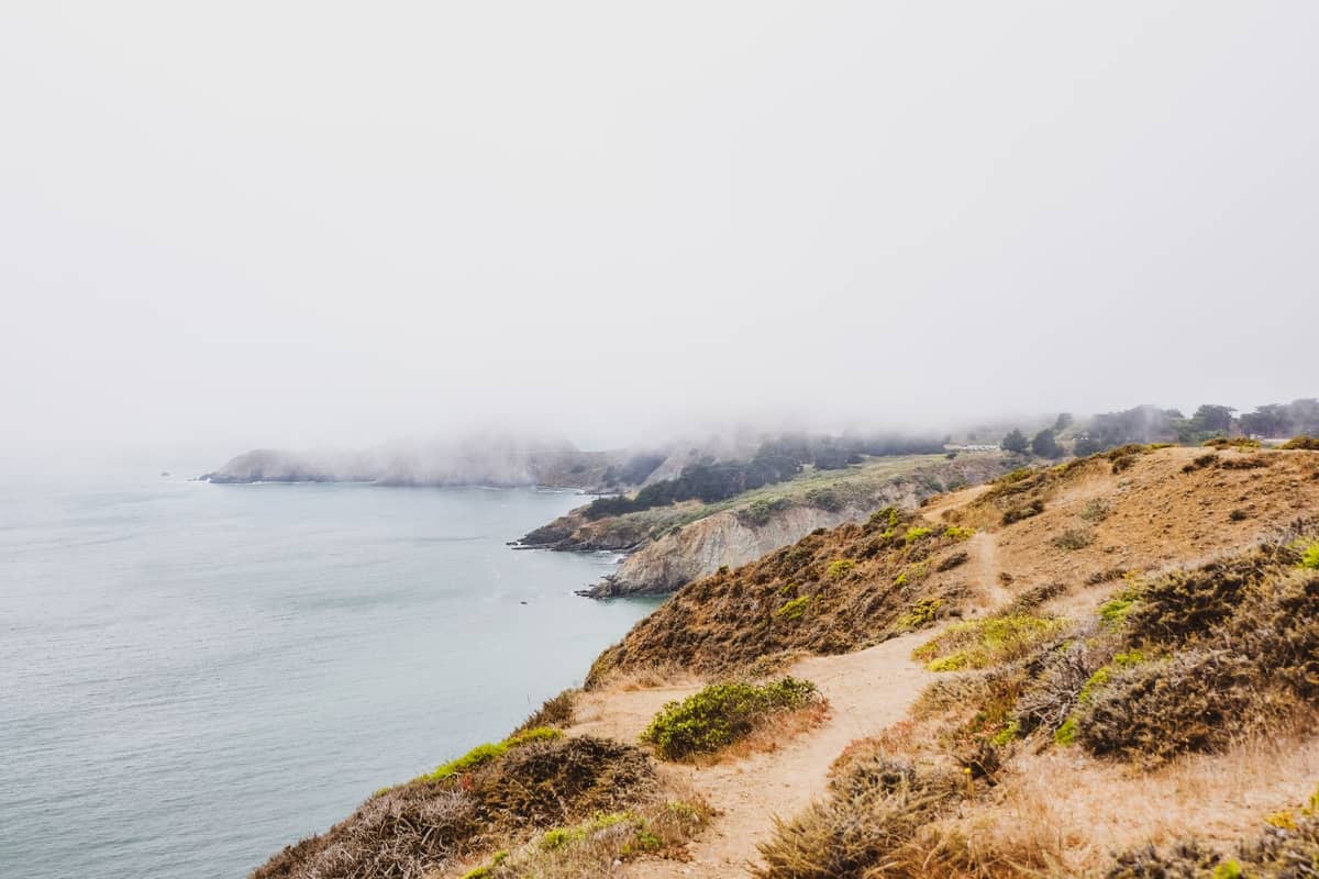
The Lands End Coastal Trail runs along a narrow shelf of coastal bluff at the northwestern corner of San Francisco, where the Pacific Ocean meets the mouth of San Francisco Bay. It is part of the California Coastal Trail and managed by the National Park Service as a section of the Golden Gate National Recreation Area. The trail follows the former railbed of the Cliff House Railway, a narrow-gauge line that carried passengers along this same shoreline in the late 19th century. The rail ties are long gone, but the alignment survives as a graded path through cypress groves and scrub, suspended above rocky outcroppings and open water.
Unlike the groomed paths inside Golden Gate Park, Lands End feels genuinely exposed. Wind comes off the water without interruption. The salt smell is constant. On clear days, the view westward is nothing but open Pacific, and on foggy mornings the cypress trees drip with moisture and the trail narrows to a gray corridor of sound. This is one of the few places in San Francisco where the city feels distant even though downtown is only four miles east.
💡 Local tip
Dress in layers no matter the season. Summer mornings at Lands End often bring dense fog and temperatures in the low 50s°F (around 11°C), even when the rest of the city is warmer. A windproof outer layer is more useful here than a heavy jacket.
The Trail Itself: What You'll Actually Walk
The most-used version of the Lands End trail runs approximately 3.2 to 3.5 miles round-trip, starting from the Lands End Lookout Visitor Center near the former Sutro Baths site at Point Lobos Avenue. From that eastern trailhead, the path heads northwest along the bluff, passing through stands of Monterey cypress planted in the early 20th century as windbreaks. The canopy here is dense enough to muffle wind and light, and the trail surface alternates between packed dirt and crushed stone.
Within the first half-mile, the path opens onto a series of rocky overlooks where, at low tide, you can see the iron ribs of ships that wrecked along this coast in the 19th and early 20th centuries. The wrecks are not always visible, but when they are, they appear as dark skeletal arcs just beneath the surface, a reminder that this stretch of water was one of the most dangerous approaches to San Francisco Bay. Bring binoculars if you have them.
The trail continues to Mile Rock Beach, a small rocky cove accessible via a steep spur path. The descent to the beach is rough and requires care on wet days. From here, the view northeast toward the Golden Gate Bridge is one of the most photographed along the entire route. The bridge appears framed between headlands, a perspective that differs from the more familiar views at Crissy Field or the Marin Headlands because you are looking from below and to the side rather than head-on.
The western end of the trail connects to the Eagle's Point overlook area and from there descends toward the former Cliff House site at Point Lobos Avenue. Combining the trail with a stop at the Sutro Baths ruins adds 20 to 40 minutes and is worth doing: the concrete foundations of the Victorian-era saltwater bathhouse sit at sea level, and the ocean surges through the old channels when the swell is up.
Tickets & tours
Hand-picked options from our booking partner. Prices are indicative; availability and final rates are confirmed when you complete your booking.
Legendary Alcatraz Island self-guided audio tour
From 14 €Instant confirmationBoba tea train experience in Sacramento
From 50 €Instant confirmationFree cancellationAlcatraz Island and Fisherman's Wharf activity combo tour
From 82 €Instant confirmationFree cancellationSonoma and Napa Valley wine tour from San Francisco
From 127 €Instant confirmationFree cancellation
How the Experience Changes by Time of Day
Early morning, before 9 a.m., the trail is used almost exclusively by local dog walkers and a small number of serious hikers. The light is soft and often filtered through low cloud. This is the best window for photography along the cypress sections, where the diffused light eliminates harsh shadows and the fog sitting over the water creates depth in wide shots. The parking lot at Lands End Lookout is mostly empty, and the trail through the trees is quiet enough that you can hear the surf below.
Midday on weekends brings a noticeable increase in foot traffic, particularly near the eastern trailhead and the Sutro Baths viewpoint. The crowd is a mix of tourists arriving from nearby Fisherman's Wharf or the Richmond District, local families, and runners. The trail is wide enough in most sections to pass comfortably, but a few of the narrow cliff-edge stretches require single-file movement, which can create brief bottlenecks.
Late afternoon, from around 3 p.m. onward in the fall and winter months, the light from the west turns the water gold and the Marin Headlands shift from green to amber. September and October, when San Francisco experiences its warmest and clearest days, produce the most dramatic afternoon light along this trail. The fog that blankets the city in June and July often retreats by September, making the fall shoulder season the strongest time to visit for unobstructed views.
⚠️ What to skip
Avoid the cliff-edge viewpoints in high wind conditions. The bluff drops sharply and there are no guardrails at several informal overlooks. Keep children close near any open edges.
Getting There and Practical Logistics
The main trailhead is at the Lands End Lookout Visitor Center, addressed at 680 Point Lobos Avenue, San Francisco, CA 94121. The visitor center is typically open daily from 9 a.m. to 5 p.m., excluding major holidays, and stocks trail maps and interpretive materials about the area's ecology and history. The adjacent parking lot is free and reported to be open from 7 a.m. to 1 a.m., but it fills quickly on sunny weekend afternoons.
Muni bus lines serve the Point Lobos Avenue and Sutro Heights area; check the SFMTA website or the Transit app for current routes and schedules, as service patterns change. For a broader look at getting around the city without a car, the guide to getting around San Francisco covers all transit options in detail.
Wear closed-toe shoes with grip. Trail runners or light hiking shoes work well. The dirt sections become slippery after rain, and the spur paths down to the beach require ankle support. The trail is not suitable for strollers on most sections, though the initial stretch east of the Merrie Way parking area is described as accessible to wheelchairs for a reasonable distance before the surface becomes more irregular.
Historical and Ecological Context
The land beneath this trail has a layered history. The Cliff House Railway, whose old railbed forms the trail's backbone, operated from 1888 until the 1920s, carrying visitors out to the Cliff House restaurant and Sutro Baths. Before that, the bluff was largely inaccessible scrubland at the edge of the city's western frontier. Adolph Sutro, the engineer, mayor, and land speculator who developed much of this area in the 1880s and 1890s, planted the cypress and eucalyptus groves that now define the trail's character.
The rocky coast below holds the remains of at least three ships. The most visible is typically the King Philip, an 1878 wreck whose iron components have resisted corrosion long enough to remain identifiable. The National Park Service's interpretive panels along the trail identify the wreck sites and provide historical context.
The bluff supports a coastal scrub habitat with coyote brush, lizardtail, and introduced species competing for ground. Red-tailed hawks are frequently seen riding thermals above the cliffs. The trail sits within the Golden Gate National Recreation Area, one of the most visited units of the national park system, which also includes the Presidio and Crissy Field to the east.
Photography Tips for This Location
The two strongest compositions along the Lands End trail are the Golden Gate Bridge framed through cypress branches from the mid-trail viewpoints, and the low-tide shipwreck views from the rock outcroppings. For the bridge shots, a focal length between 70mm and 135mm (full-frame equivalent) compresses the distance and isolates the towers against the Marin Headlands. For shipwreck shots, low tide timing is essential: check a tide chart before you go and aim to be at the overlooks within an hour of low water.
In foggy conditions, which are common from June through August, the trail through the cypress grove shoots beautifully in soft light. The moisture on the bark and the diffused background create atmospheric images that are difficult to replicate anywhere else in the city. Bring a lens cloth to wipe moisture from your glass. A polarizing filter helps cut glare on the water when the sun does appear.
ℹ️ Good to know
The Lands End Labyrinth, a stone spiral laid out on a rocky ledge overlooking the Pacific, is a popular photography subject. Its exact location shifts occasionally as the stones are rearranged by visitors and tides. Look for a spur path leading toward the water between the main trail and Mile Rock Beach.
Who Should Reconsider This Trail
Lands End is not the right choice for every visitor. If you have significant mobility limitations, only the short initial section of the trail near the parking lot is comfortably accessible. The full route involves stairs, uneven dirt surfaces, and exposed sections where footing is uncertain in wet weather. Travelers looking primarily for a leisurely waterfront walk with flat pavement and immediate amenities would find the Crissy Field promenade or the Embarcadero easier to navigate.
Families with very young children in strollers should plan for the trail to be inaccessible beyond the first stretch. That said, older children who can handle a moderate amount of scrambling and uneven ground will find the wrecks, the labyrinth, and the beach overlooks genuinely engaging. It is also worth noting that the summer fog is not just a mild inconvenience here: on a June morning when downtown San Francisco is clear and warm, Lands End can be cold, damp, and near-zero-visibility. That is part of its character, but travelers expecting sunny coastal scenery should consider visiting in September or October.
Insider Tips
- Check a tide table before visiting. The shipwreck remains off the rocky outcroppings are only visible within roughly an hour of low tide. High tide covers them completely. The NOAA tide predictor for San Francisco Bay gives accurate readings.
- The stone labyrinth near Mile Rock Beach is not marked on official maps or trailhead signs. Walk toward the water on any of the informal spur paths between the main trail and the cliff edge on the western half of the route. It appears and disappears depending on who has maintained it recently.
- The Lands End Lookout Visitor Center often has free printed trail maps, which are more detailed than anything available on most hiking apps for this specific area. Pick one up before you start rather than relying on phone GPS, which loses signal in the cypress sections.
- If you are combining Lands End with Sutro Baths, enter the baths from the trailhead side rather than the Cliff House parking area below. The upper viewpoint gives a complete perspective on the scale of the ruins before you descend to walk through them.
- Weekday mornings between 7 and 9 a.m. offer a version of the trail that weekend visitors rarely experience: almost no tourists, active wildlife including harbor seals on the rocks below, and the kind of quiet that makes it feel like a genuinely remote coast rather than an urban park.
Who Is Lands End Coastal Trail For?
- Hikers who want ocean views without driving out of the city
- Photographers seeking fog-filtered light and Golden Gate Bridge angles not found at more crowded spots
- History-minded travelers interested in maritime wrecks and the city's Victorian-era leisure infrastructure
- Budget travelers: the trail, the Sutro Baths ruins, and the viewpoints are all free
- Locals and repeat visitors who already know the standard tourist circuit and want something that feels less rehearsed
Nearby Attractions
Other things to see while in Lands End:
- China Beach
Set between Baker Beach and Lands End in San Francisco's Sea Cliff neighborhood, China Beach is a small, free sandy cove within the Golden Gate National Recreation Area, managed in partnership by the National Park Service and the Golden Gate National Parks Conservancy.
- Legion of Honor
Perched above the Pacific in Lincoln Park, the California Palace of the Legion of Honor is a three-quarter-size replica of a Parisian neoclassical palace housing 4,000 years of art. The setting alone, with ocean fog rolling past the colonnade and a cast of Rodin's The Thinker standing sentinel in the courtyard, makes this one of the most visually striking museum visits in California.
- Ocean Beach
Ocean Beach is a 3.5-mile stretch of wild Pacific shoreline forming the western edge of San Francisco. Part of Golden Gate National Recreation Area, it is free to visit, open around the clock, and offers a dramatically different mood than the city's polished tourist corridors.
- Sutro Baths
Once the world's largest indoor swimming complex, the Sutro Baths today survive as concrete ruins on the edge of the Pacific. Free to visit at any hour, this National Recreation Area site combines Victorian-era history, dramatic coastal scenery, and an eerie, photogenic atmosphere unlike anything else in San Francisco.