Angel Island State Park: The Bay Island Worth the Ferry Ride
Angel Island State Park sits in the middle of San Francisco Bay, offering miles of hiking trails, layers of military and immigration history, and 360-degree views of the city skyline, Marin headlands, and beyond. Getting there requires a ferry, which is part of the appeal — the island feels removed from city life, even though San Francisco is visible the entire time.
Quick Facts
- Location
- Angel Island State Park, P.O. Box 318, Tiburon, CA 94920 — located in San Francisco Bay, accessible by ferry only
- Getting There
- Golden Gate Ferry from the San Francisco Ferry Building, or Angel Island–Tiburon Ferry from Tiburon. Private boats may dock at the island.
- Time Needed
- 3 to 6 hours; a full day if hiking the perimeter trail or exploring multiple sites
- Cost
- No separate general park admission fee at the gate; ferry fares apply (Golden Gate Ferry tickets from San Francisco include the state park entrance fee). Check current fares with Golden Gate Ferry or Angel Island–Tiburon Ferry before visiting.
- Best for
- Hikers, history enthusiasts, photographers, families with older children, and anyone wanting a full-day escape from the city
- Official website
- www.parks.ca.gov/angelisland
What Angel Island Actually Is
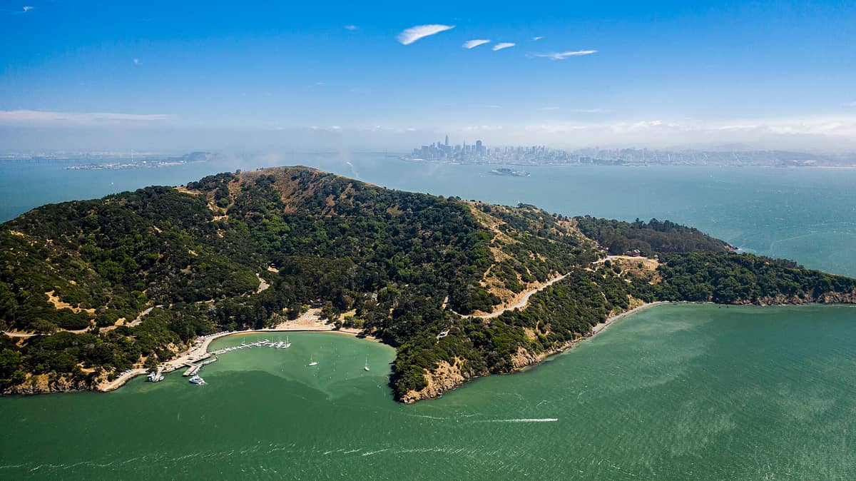
Angel Island State Park is the largest natural island in San Francisco Bay, sitting roughly in the middle of the water between the city, Marin County, and the East Bay. From the ferry deck, it looks compact and forested — a green dome rising from the blue-gray bay. Once you arrive at Ayala Cove, the island's main landing area, that impression changes. There are miles of trails, a ring road that circles the island, former military installations, the restored Immigration Station, and several high points offering unobstructed views in every direction.
The island is managed by California State Parks and has no permanent residents. There are no cars, no traffic noise, and no urban sprawl. What you do hear: wind through cypress trees, the distant foghorns from the bay, gulls, and the occasional tram that serves visitors who prefer not to walk. It is a rare place where the San Francisco skyline is always visible but the city's noise is not.
ℹ️ Good to know
Ferry service is limited on winter weekdays and schedules vary by season. Confirm departure times directly with Golden Gate Ferry (from the San Francisco Ferry Building) or the Angel Island–Tiburon Ferry before you plan your day. Missing the last ferry back is a real possibility if you lose track of time.
How to Get There
There are two main public ferry routes. From San Francisco, Golden Gate Ferry departures leave from the Ferry Building on the Embarcadero. From Tiburon, the Angel Island–Tiburon Ferry provides a shorter crossing from the Marin side. Both services land at Ayala Cove on the island's northwest shore. Private boats can dock at the cove as well, subject to available moorings.
Getting to the Ferry Building from downtown San Francisco is straightforward. BART and Muni Metro serve Embarcadero Station a short walk away, and the F-line historic streetcar runs along Market Street and the Embarcadero. Build in extra time on summer weekends when ferry lines form early. Arriving at the terminal at least 20 minutes before departure is advisable during peak season.
💡 Local tip
The Tiburon ferry crossing takes about 10 minutes versus roughly 30 minutes from San Francisco — but reaching Tiburon first adds transit time unless you are already in Marin County. If you are coming from the city, the Ferry Building departure is usually more convenient.
Tickets & tours
Hand-picked options from our booking partner. Prices are indicative; availability and final rates are confirmed when you complete your booking.
Sonoma and Napa Valley wine tour from San Francisco
From 127 €Instant confirmationFree cancellationGo City | San Francisco Explorer Pass
From 76 €Instant confirmationFree cancellationMuir Woods and Sausalito guided tour with transportation
From 82 €Instant confirmationFree cancellationSan Francisco CityPASS
From 77 €Instant confirmationFree cancellation
Arrival at Ayala Cove and the First Hour
The ferry docks at Ayala Cove, a sheltered inlet on the island's northwest side. The cove is calm and protected, which is why it was first used as an anchorage by Spanish explorer Juan Manuel de Ayala in 1775 — the first European expedition to sail into San Francisco Bay. A small beach, picnic tables, a visitor center, a cafe, and restroom facilities are clustered here. This is where most visitors orient themselves before choosing a route.
On a clear morning, the light hits the bay at a low angle and the water is a deep, saturated blue. The cove smells of salt and eucalyptus. The eucalyptus trees on Angel Island are not native — they were planted during military occupation in the late 19th and early 20th centuries and now dominate certain sections of the island. Native coastal scrub, bay laurel, and live oak cover other areas, particularly on the drier southern and eastern slopes.
The Trails: What Each Route Offers
The Perimeter Road is a paved, 5-mile loop that circles the island and passes every major site. It is moderately hilly but walkable for most visitors at a comfortable pace. Electric trams run along this route during peak season for those who want a guided overview without the full walk. Cyclists can also rent bikes near the cove.
For views, the trail to Mount Livermore is the one that matters. At 788 feet, the summit offers a 360-degree panorama that takes in the Golden Gate Bridge, the San Francisco skyline, the Bay Bridge, Mount Tamalpais to the north, and the East Bay hills. On a clear day in September or October — when San Francisco's typical summer fog has cleared and temperatures are at their most reliable — the view from the top is genuinely extraordinary. On foggy summer mornings, the summit can be completely socked in, which is worth knowing before you commit to the climb.
For context on how fog patterns affect Bay Area outdoor plans, the best time to visit San Francisco breaks down seasonal weather in useful detail.
⚠️ What to skip
Trails can be wet and slippery after rain. The perimeter road is paved, but the summit trail involves unpaved sections with loose gravel. Wear closed-toe shoes with grip. Sandals are not appropriate for anything beyond the cove area.
The Immigration Station: The Island's Most Significant Site
Between 1910 and 1940, Angel Island served as the primary immigration processing station on the West Coast of the United States. More than 300,000 immigrants passed through, the majority from China, Japan, Korea, and the Philippines. For Chinese immigrants, the experience was often harrowing. Under the Chinese Exclusion Act, which remained in effect until 1943, Chinese arrivals faced lengthy detentions, interrogations, and in many cases deportation. Some were held for weeks or months in the station's barracks.
The preserved barracks walls still carry poetry carved or brushed in Chinese characters by detainees during their confinement. These inscriptions, some expressing sorrow, others defiance, are one of the most affecting things you will encounter at any historic site in the Bay Area. The Immigration Station is now a museum with exhibits covering the full range of people who passed through, including European immigrants who processed much more quickly through the station's separate facilities.
The Immigration Station operates on its own schedule with guided and self-guided tours. Confirming current hours and any tour booking requirements before your visit is important, as the station may not be open every day the park is accessible.
Military History and the Forgotten Installations
Angel Island's military history spans from the Civil War era through World War II and the Cold War. Camp Reynolds on the island's west side dates to 1863 and was used to process Union Army soldiers. Fort McDowell on the east side served as a discharge point for soldiers returning from the Pacific in World War II. Fortifications, gun batteries, and barracks from multiple eras are visible throughout the island, many in varying states of preservation and decay.
The Nike Missile Site on the island's east side is one of the more unusual relics — a Cold War-era anti-aircraft installation that was operational into the 1960s. It has been partially restored and is accessible. Walking through it after visiting the Immigration Station gives a compressed sense of the island's layered history: a place that was, at different times, a military fortress, a processing point for immigrants, and a Cold War outpost, all within a few square miles.
Photography and the Best Times of Day
The island's position in the middle of the bay makes it unusual for photography. You can frame the Golden Gate Bridge from the west-facing shores with no foreground clutter. The San Francisco skyline appears across the water from the island's southern side. Early morning arrivals — taking the first ferry of the day — get the cove nearly to themselves and catch soft light across the water before the bay chop picks up.
Late afternoon light on the city skyline, viewed from the island's south side, is consistently good from late summer through autumn. Photographers who want to compare vantage points should also look at the best viewpoints in San Francisco for context on how Angel Island compares to land-based options.
💡 Local tip
Bring a wide-angle lens or use your phone's ultrawide mode for the Mount Livermore summit panorama. The 360-degree field of view defeats most standard focal lengths.
Practical Details for the Day
There is a small cafe near Ayala Cove, but its hours and seasonal availability vary. Bringing your own food and water is the more reliable approach, especially if you plan to hike. The island has picnic areas with tables at multiple locations. There are no food options on the trails themselves.
Restrooms are available at Ayala Cove and at several points around the perimeter. Cell service on the island is inconsistent, particularly on the north and east sides. Download maps before you arrive. Parking is not relevant for most visitors since you are arriving by ferry, but if driving to the Tiburon terminal, street and lot parking exists in Tiburon near the ferry dock.
Visitors with disabilities who need assistance should contact the park directly at (415) 435-1915 before visiting, as California State Parks notes that advance contact is recommended to coordinate access needs.
For the broader context of a day built around ferry travel in the bay, the San Francisco ferry guide covers routes, terminals, and ticketing across the region.
Insider Tips
- Take the first ferry of the day, not the second. The first departure lands you on the island before the main crowd arrives, and you will have the cove, the trails, and the summit largely to yourself for the first hour or two.
- The Immigration Station poetry inscriptions are inside the barracks — easy to miss if you do a quick exterior walkthrough. Ask a ranger or check the station map to locate the carved and painted characters specifically. They are the most historically significant things on the island.
- September and October are the island's best months. Summer fog regularly obscures the summit view and makes the crossing choppy and cold. The autumn window typically offers clear skies, calm water, and the best panoramas from Mount Livermore.
- Pack layers even if the city feels warm when you depart. The bay crossing and the island's exposed ridgelines can be 10 to 15 degrees cooler than San Francisco, and the wind on the summit is consistent.
- If you want to camp on the island, Angel Island has campsites that can be reserved through the California State Parks reservation system. Staying overnight is the only way to experience the island at dusk and dawn, when the bay light is at its most atmospheric and the day-trip crowd is entirely gone.
Who Is Angel Island State Park For?
- Hikers and trail walkers who want a genuine half-day or full-day route with no car traffic
- History travelers interested in immigration history, military history, or Cold War-era sites
- Photographers looking for unobstructed bay views and city skyline angles not available from the mainland
- Families with children old enough for moderate trail walking — the tram option works for younger kids
- Visitors who want a genuine break from the city without leaving the Bay Area
Nearby Attractions
Combine your visit with:
- 16th Avenue Tiled Steps
The 16th Avenue Tiled Steps Project is a community-made mosaic staircase of 163 steps stretching through San Francisco's Golden Gate Heights neighborhood (a sub-area of the Inner Sunset), depicting a journey from the ocean floor to the night sky. It's free, photogenic, and connects to one of the city's best lesser-known hilltop viewpoints.
- Asian Art Museum of San Francisco
One of the largest Asian art collections in the Western world, housed in a transformed Beaux-Arts landmark at Civic Center. From ancient Chinese bronzes to contemporary Southeast Asian installations, the museum rewards careful visitors who know what to look for.
- UC Berkeley Campus
The University of California, Berkeley sits on a hillside above San Francisco Bay, offering free access to striking Beaux-Arts architecture, landmark museums, and open green spaces. A short BART ride from San Francisco, it rewards curious visitors with history, intellectual energy, and some of the best campus scenery in the country.
- Bernal Heights Park
Perched at 433 feet above sea level, Bernal Heights Park delivers sweeping 360-degree views of San Francisco, the Bay, and beyond — completely free. The 26.3-acre summit park draws locals, dog walkers, and sunrise seekers who want panoramas without the tourist pressure of Twin Peaks or Dolores Park.