Bernal Heights Park: San Francisco's Best Panoramic Views Without the Crowds
Perched at 433 feet above sea level, Bernal Heights Park delivers sweeping 360-degree views of San Francisco, the Bay, and beyond — completely free. The 26.3-acre summit park draws locals, dog walkers, and sunrise seekers who want panoramas without the tourist pressure of Twin Peaks or Dolores Park.
Quick Facts
- Location
- 10 Bernal Heights Blvd, San Francisco, CA 94110
- Getting There
- Muni buses serve the Bernal Heights neighborhood; check SFMTA for current routes closest to the trailhead
- Time Needed
- 45 minutes to 1.5 hours depending on pace and route
- Cost
- Free — no admission fee
- Best for
- Panoramic city views, dog walking, sunrise visits, casual hiking
What Bernal Heights Park Actually Is
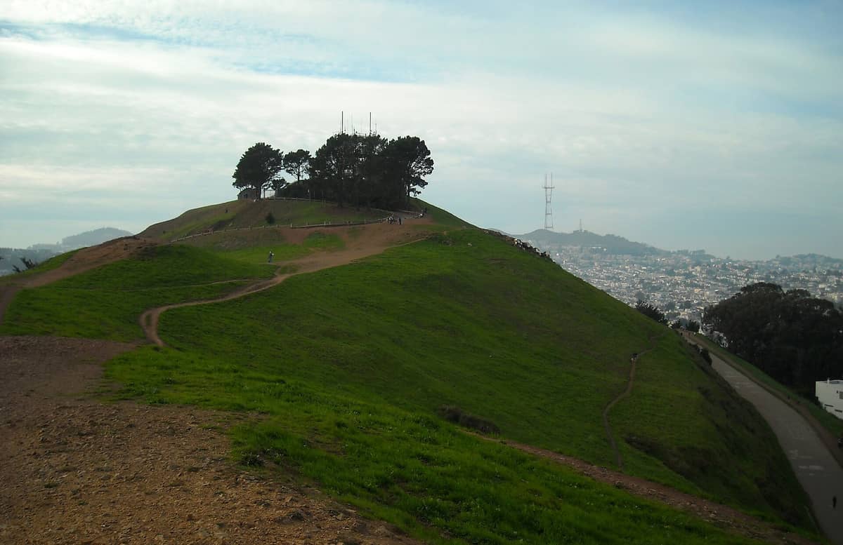
Bernal Heights Park occupies the upper portion of Bernal Hill in the southern part of San Francisco, with the summit sitting at about 433 feet. The park covers approximately 26.3 acres and is managed by San Francisco Recreation and Parks. Unlike the city's more famous hilltops, this one sees a steady stream of neighborhood regulars rather than tour buses, which changes the atmosphere considerably.
The park is open daily from 5:00 AM to midnight and is entirely free to visit. There are no ticketing booths, no reservation systems, and no vendors at the top. What you find instead is a wide dirt loop trail circling the summit, a city-designated off-leash dog area, and unobstructed views in nearly every direction.
💡 Local tip
Arrive early on weekday mornings (before 8:00 AM) for the most peaceful experience. By mid-morning on weekends, the summit fills with dog owners and families, which is lively but less meditative.
The Views: What You Can Actually See
The summit loop trail is the park's main draw, and the views from it are comprehensive. On a clear day, you can see the downtown skyline to the north, the Bay Bridge and Oakland hills to the east, the San Francisco International Airport approach corridor to the south, and the hills of the western neighborhoods fading toward the Pacific. The Salesforce Tower and Transamerica Pyramid are identifiable landmarks that help orient you.
The view eastward toward the bay is particularly striking in the late afternoon when the light catches the water. For western city views and sunsets, the upper portions of the trail offer sightlines toward the Sunset District and beyond. If broader San Francisco sightseeing is your priority, pairing this with a visit to Twin Peaks gives useful comparison, though Twin Peaks sits higher and sees significantly more vehicle traffic.
Fog is a real variable. San Francisco's marine layer, driven by its warm-summer Mediterranean climate, is strongest in June through August. Summer mornings frequently arrive with low cloud cover that can obscure the bay entirely. September and October are statistically the clearest months, with warmer temperatures and less fog intrusion. Winter visits can be stunning on clear days but arrive prepared for wind and cool temperatures.
⚠️ What to skip
Do not count on summer mornings for clear views. The marine layer regularly sits below the summit but can roll in quickly. Check a San Francisco fog forecast, not just a weather app, before planning a sunrise visit in June or July.
Tickets & tours
Hand-picked options from our booking partner. Prices are indicative; availability and final rates are confirmed when you complete your booking.
Sonoma and Napa Valley wine tour from San Francisco
From 127 €Instant confirmationFree cancellationGo City | San Francisco Explorer Pass
From 76 €Instant confirmationFree cancellationMuir Woods and Sausalito guided tour with transportation
From 82 €Instant confirmationFree cancellationSan Francisco CityPASS
From 77 €Instant confirmationFree cancellation
The Trail and Physical Experience
The main summit loop is an unpaved dirt trail that encircles the top of the hill. The surface is compact earth, loose in dry conditions and slippery when wet. Most of the loop is walkable in ordinary athletic shoes, but the incline from the street-level entrances to the ridge is steep enough that proper footwear makes a difference. Allow 20 to 30 minutes for the full loop at a relaxed pace, longer if you stop frequently for photos or to let a dog sniff around.
The off-leash dog area is one reason locals cite Bernal Heights as a preferred destination over more formal parks. Dogs run freely across much of the upper park area, and the culture here is distinctly neighborhood-oriented: owners know each other, conversations happen naturally, and there is none of the self-conscious tourist energy that characterizes some of the city's more photographed spots.
The trail lacks formal benches at the summit, so bringing a small mat or jacket to sit on extends the stay considerably. Restrooms are not available at the summit itself; plan accordingly before heading up.
How the Experience Changes Through the Day
Early morning, roughly 5:30 to 7:30 AM, has a specific quality that no other time replicates. The city sounds below are muted, the light is soft and directional, and on clear days the Bay reflects the early sky in a way that disappears once the day brightens fully. Joggers and dog owners dominate at this hour. The grass holds dew, and the soil path is firmer underfoot.
Midday brings families and impromptu picnickers on weekends. The wind, which is a near-constant at the summit, picks up in the afternoon as the inland areas heat up and draw air off the Pacific. By 2:00 PM on most days, the gusts are noticeable enough to make sitting still uncomfortable without a windbreak layer. Photographers find the golden-hour window before sunset particularly productive, with warm light falling across the downtown towers.
Evening visits, up until the midnight close, are quieter again. The city lights from this elevation are a different kind of rewarding than the daytime panorama, and the hill feels less exposed once the afternoon wind dies down after dark.
Getting There and Practical Logistics
Bernal Heights Park sits in the southern part of San Francisco. Muni bus routes serve the surrounding neighborhood; check the SFMTA website for current service, as routes and schedules change. The park address is 10 Bernal Heights Blvd, and the main trail access points are near Anderson Street. If you're navigating the broader city transit system, the guide to getting around San Francisco covers Muni, BART, and walking options in useful detail.
Street parking exists in the residential streets surrounding the hill and is generally easier to find here than in more central neighborhoods, though weekend mornings can fill the blocks nearest the trailhead. The walk from any of the surrounding streets to the summit takes 10 to 20 minutes depending on your entry point.
There are no food or drink vendors in the park itself. Bring water, especially in warmer months. The Bernal Heights neighborhood below has cafes and small grocery options along Cortland Avenue, which functions as the neighborhood's main commercial street and is worth exploring before or after the climb.
ℹ️ Good to know
Bernal Heights Park is a local space. The surrounding streets are a residential neighborhood, not a tourist district. Keep noise levels appropriate, especially on early morning visits.
Photography Notes
The summit loop offers clean sightlines in multiple directions, which means a single visit can yield shots of the downtown skyline, the Bay Bridge, and the western residential districts without repositioning dramatically. For the sharpest cityscape shots, a mid-range lens or a phone camera with a good zoom performs better than ultra-wide angles, which can make the downtown towers appear smaller than they look to the naked eye.
Sunrise and late afternoon before golden hour are the two best windows for color and contrast. If your San Francisco itinerary is tight, the best viewpoints in San Francisco guide compares Bernal Heights with other elevated spots across the city, which helps you prioritize based on your specific goals.
Who Should Skip This Park
Travelers who want manicured facilities, visitor services, or interactive exhibits will not find them here. The park is rugged by urban standards: no seating, no food, minimal signage. Anyone with limited mobility should note that the trail from street level to the summit involves sustained steep grades on uneven terrain; the summit loop itself is not step-free.
If you are visiting San Francisco for only one or two days and already planning a stop at Twin Peaks or Dolores Park, a second hilltop may be redundant unless the specific neighborhood atmosphere or dog-friendly environment is appealing. Bernal Heights earns its visit most for people who want to see the city from a perspective that residents actually use, not staged for tourists.
Insider Tips
- The western side of the summit loop, facing the Sunset District, is less frequented than the eastern side facing downtown. It offers quieter seating spots and a different perspective on the city's residential sprawl toward the Pacific.
- Cortland Avenue, the commercial street at the foot of the hill, has independent coffee shops worth stopping at before the climb. It's a neighborhood main street with almost no tourist-oriented businesses.
- Wind is strongest between roughly 1:00 PM and 5:00 PM due to the thermal pattern off the bay. If you visit in the afternoon, a windproof layer is not optional — it's the difference between a pleasant hour and a miserable one.
- The off-leash area covers most of the upper park, but city regulations require dogs to be under voice control. The regulars here take this seriously; dogs that chase other dogs persistently are usually redirected quickly by their owners.
- For the clearest views with the least fog, aim for a weekday morning in late September or October, ideally after a dry spell of several days. The city is statistically warmest and clearest in this window.
Who Is Bernal Heights Park For?
- San Francisco residents and repeat visitors who want a non-touristy viewpoint with genuine neighborhood character
- Dog owners looking for a well-maintained off-leash area with open terrain
- Photographers targeting early-morning or golden-hour cityscape shots without competing with tour groups
- Walkers and casual hikers who want a short but rewarding urban trail under 90 minutes
- Budget travelers: the park is completely free and requires no advance booking
Nearby Attractions
Combine your visit with:
- 16th Avenue Tiled Steps
The 16th Avenue Tiled Steps Project is a community-made mosaic staircase of 163 steps stretching through San Francisco's Golden Gate Heights neighborhood (a sub-area of the Inner Sunset), depicting a journey from the ocean floor to the night sky. It's free, photogenic, and connects to one of the city's best lesser-known hilltop viewpoints.
- Angel Island State Park
Angel Island State Park sits in the middle of San Francisco Bay, offering miles of hiking trails, layers of military and immigration history, and 360-degree views of the city skyline, Marin headlands, and beyond. Getting there requires a ferry, which is part of the appeal — the island feels removed from city life, even though San Francisco is visible the entire time.
- Asian Art Museum of San Francisco
One of the largest Asian art collections in the Western world, housed in a transformed Beaux-Arts landmark at Civic Center. From ancient Chinese bronzes to contemporary Southeast Asian installations, the museum rewards careful visitors who know what to look for.
- UC Berkeley Campus
The University of California, Berkeley sits on a hillside above San Francisco Bay, offering free access to striking Beaux-Arts architecture, landmark museums, and open green spaces. A short BART ride from San Francisco, it rewards curious visitors with history, intellectual energy, and some of the best campus scenery in the country.