Twin Peaks, San Francisco: The City's Most Rewarding Panorama
Twin Peaks is a free municipal park in the central part of San Francisco, topping out at 925 feet with sweeping 360-degree views of the Bay Area. The two summits, Eureka Peak to the north and Noe Peak to the south, are open daily from 5 a.m. to midnight and reward visitors with some of the most unobstructed sightlines in the city.
Quick Facts
- Location
- 501 Twin Peaks Blvd, San Francisco, CA 94114 (main parking: 100 Christmas Tree Point Rd)
- Getting There
- Multiple Muni bus routes serve the Twin Peaks area; check SFMTA trip planner for current lines
- Time Needed
- 45 minutes to 1.5 hours depending on whether you hike both summits
- Cost
- Free; no entry fee or parking charge
- Best for
- Panoramic city views, photography, sunset watching, clear autumn days
- Official website
- sfrecpark.org/destination/twin-peaks
What Twin Peaks Actually Is
Twin Peaks is a pair of prominent hills in the central part of San Francisco, managed as a municipal park by San Francisco Recreation and Parks. The two summits, Eureka Peak to the north and Noe Peak to the south, stand roughly 660 feet apart and both top out near 925 feet above sea level. That elevation, combined with relatively little development on the hillsides, gives the park some of the most genuinely unobstructed urban panoramas you will find anywhere in the city.
The park covers approximately 31 acres and the terrain is a mix of paved roads, a main parking and viewpoint area at Christmas Tree Point, and dirt trails that wind up both summits. The hills are largely open grassland, giving the place a sparse, windswept character that feels quite different from the wooded corridors of Golden Gate Park or the Presidio. There are no cafes, no vendors, and no facilities beyond basic infrastructure. What you get here is the view.
ℹ️ Good to know
The park is open daily from 5:00 a.m. to midnight. Admission is free, and there is no charge to use the parking lots at the summit viewing area near Christmas Tree Point.
The View: What You Are Actually Looking At
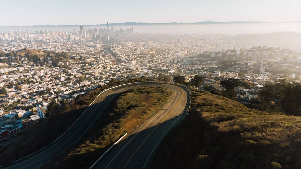
On a clear day from Christmas Tree Point or either summit, the full sweep of the city unfolds. To the north you can trace the line of the Bay, spot Alcatraz Island sitting low in the water, and follow the spans of the Bay Bridge east toward Oakland. The Golden Gate Bridge appears to the northwest, often partially veiled in fog even when the rest of the city is clear. Looking west, the Richmond and Sunset districts extend in flat grids toward the Pacific, with Ocean Beach visible as a thin ribbon of pale sand on the horizon.
Below and to the east, downtown's Financial District clusters around the Transamerica Pyramid and the newer Salesforce Tower. The Mission District and the Castro spread out to the southeast, and on very clear days Mount Diablo and the hills of the East Bay form a long ridge across the horizon. The scale of the city becomes comprehensible up here in a way it rarely does from street level.
The Spanish name for the peaks, Los Pechos de la Chola, is traditionally associated with early Spanish-speaking settlers on the peninsula. By the late 19th century the English name Twin Peaks had become the dominant local usage and has remained official since. The peaks sit near the center of the San Francisco peninsula, which is why the view is so geometrically satisfying: you are not at an edge looking in one direction, you are at the middle looking outward in every direction simultaneously.
Tickets & tours
Hand-picked options from our booking partner. Prices are indicative; availability and final rates are confirmed when you complete your booking.
Sonoma and Napa Valley wine tour from San Francisco
From 127 €Instant confirmationFree cancellationGo City | San Francisco Explorer Pass
From 76 €Instant confirmationFree cancellationMuir Woods and Sausalito guided tour with transportation
From 82 €Instant confirmationFree cancellationSan Francisco CityPASS
From 77 €Instant confirmationFree cancellation
How the Experience Changes by Time of Day
Morning visits, roughly between 7 and 9 a.m., tend to be the quietest. The air is cold and often sharp, and fog may still be burning off from the lower neighborhoods. On foggy mornings you can stand above a white layer of cloud with just the tops of the tallest downtown towers poking through. That is a genuinely striking sight, though it means you lose most of the cityscape. If your priority is the panoramic view, fog is not your friend.
Midday draws the most visitors, particularly tour buses and ride-share drop-offs at Christmas Tree Point. The parking area fills quickly between roughly 11 a.m. and 3 p.m. on weekends. The light is flat and bright, which is not ideal for photography but makes the view sharp and easy to read. Wind is almost always present on the exposed summits, and midday tends to be when gusts peak.
Sunset brings the most dramatic conditions. The western sky goes orange and pink behind the Pacific, the city lights begin to appear below, and the Golden Gate Bridge catches the last direct light before it disappears into silhouette. Arrive at least 20 minutes before actual sunset to claim space at the viewpoint railing. Temperatures drop sharply once the sun goes. Bring a windproof layer regardless of how warm it felt at sea level.
After dark, Twin Peaks becomes one of the best spots in San Francisco for city light photography. The Bay Bridge lights up with its LED installation, Alcatraz shows its beacon, and the grid of the city below takes on a warm orange glow. The park stays open until midnight, so there is time to linger well after sunset if the cold does not drive you off.
💡 Local tip
September and October are the warmest and clearest months in San Francisco due to the Mediterranean climate pattern. This is when Twin Peaks delivers its best panoramas. Summer (June through August) is peak tourist season but also peak fog season: morning and afternoon marine layer frequently reduces visibility significantly.
Getting There and Navigating the Park
By car, the most direct approach from central San Francisco is to follow Market Street west until it becomes Portola Drive, then turn right onto Twin Peaks Boulevard and continue uphill to the parking areas. Christmas Tree Point, at 100 Christmas Tree Point Road, is where most visitors stop: it is a paved viewpoint with a railing, a small lot, and the most accessible vantage point in the park. From here you can see most of the view without leaving the pavement.
By public transit, multiple Muni bus routes serve the Twin Peaks neighborhood. Check the SFMTA trip planner at sfmta.com for current routes and schedules, as service details change. If you are coming from the Castro or the Upper Market area, the walk up Twin Peaks Boulevard is steep but manageable in about 20 to 25 minutes. For broader context on getting around the city, the guide to getting around San Francisco covers Muni, BART, cable cars, and rideshare options in detail.
From Christmas Tree Point, unpaved trails lead up to both summits. Noe Peak to the south and Eureka Peak to the north each add roughly 10 to 15 minutes of hiking from the parking area. The trails are packed earth and can be slippery after rain. Footwear with some grip is strongly recommended if you plan to go beyond the paved viewpoint. The summits offer slightly higher vantage points than Christmas Tree Point and significantly fewer people, but the trails are not maintained to a formal standard.
⚠️ What to skip
Wind on the exposed summits can be strong enough to make standing uncomfortable. Even on warm days in the city below, temperatures at 925 feet with full wind exposure can feel 15 to 20 degrees colder. A windproof outer layer is not optional; it is practical necessity.
Accessibility and Practical Considerations
Christmas Tree Point and the main parking areas are accessible by paved road and are the primary option for visitors with limited mobility. The viewpoint railing at Christmas Tree Point provides a full panorama without requiring any hiking. The summit trails involve uneven terrain, elevation gain, and no formal accessibility infrastructure.
The SFMTA and city partners have been working on a project called Twin Peaks For All, which aims to improve walking and cycling access and reduce vehicle-pedestrian conflicts on Twin Peaks Boulevard. Check sfmta.com for current status, as road layouts and access points may change as that project progresses.
There are no food or drink options at Twin Peaks. If you want to eat before or after your visit, the Castro neighborhood directly below has a dense concentration of cafes and restaurants. Twin Peaks pairs naturally with a visit to Dolores Park in the Mission District, which is a short drive or Muni ride away and offers a very different kind of outdoor experience at lower elevation.
Photography at Twin Peaks
The light at Twin Peaks rewards patience. The golden hour before sunset is the most photogenic window: warm directional light hits the downtown towers from the west, the Bay Bridge cables catch the glow, and the sky behind you goes through a rapid sequence of colors. A wide-angle lens captures the full 180-degree arc of the city, while a medium telephoto lets you isolate specific landmarks like the Bay Bridge or Coit Tower against the hillside neighborhoods.
For night shots, a tripod is essential. The city grid below produces a clean, readable light pattern from both summits, and long exposures bring out the bridge illumination and the movement of car headlights on the freeway interchanges below. If you are building a full itinerary around San Francisco's best aerial perspectives, the guide to the best views in San Francisco puts Twin Peaks in context alongside other high-elevation viewpoints across the city.
Who Will Not Enjoy This Visit
Twin Peaks is not a comfortable destination for visitors who are sensitive to wind or cold, or who expect a polished experience. There are no benches, no shade, no restrooms at the summit, and no shelter from the wind at either peak. On foggy days, which are common from June through August, the view can be almost entirely obscured: you may arrive to find yourself standing in a gray cloud with visibility under 100 feet. That is not a rare edge case; it happens regularly during summer mornings.
Visitors traveling with young children in strollers will find Christmas Tree Point accessible but the summit trails unsuitable. Anyone who has difficulty on uneven or sloped terrain should stay at the paved viewpoint and not attempt the dirt paths to either peak, which involve sustained steep sections without handrails.
Insider Tips
- Arrive on a weekday afternoon in late September or October for the best combination of clear skies, warm temperatures, and manageable crowds. This is the meteorologically clearest period of the San Francisco year.
- The north summit, Eureka Peak, has a slightly better angle on the Bay Bridge and downtown skyline than the south peak. If you only climb one, go north.
- Rideshare drop-offs at Christmas Tree Point are quick and efficient. Because parking fills fast on weekend afternoons, getting dropped off and calling a pickup when you are done is often smoother than driving yourself.
- Locals who know the park walk up from the Castro side via the trail off Clayton Street rather than driving up Twin Peaks Boulevard. It is a steeper approach but avoids the traffic entirely and gives a better sense of the neighborhoods below.
- The park's open grassland provides almost no natural shelter from wind. Experienced visitors arrive with a compact packable jacket tucked in a bag even when wearing a t-shirt at sea level.
Who Is Twin Peaks For?
- First-time visitors who want to orient themselves visually across the entire city in one stop
- Photographers seeking panoramic city light shots at golden hour or after dark
- Travelers visiting in September or October who want to make the most of San Francisco's clearest weather
- Couples looking for a free, low-effort sunset spot with genuine dramatic impact
- Hikers wanting a short but rewarding summit walk embedded inside a full city day
Nearby Attractions
Combine your visit with:
- 16th Avenue Tiled Steps
The 16th Avenue Tiled Steps Project is a community-made mosaic staircase of 163 steps stretching through San Francisco's Golden Gate Heights neighborhood (a sub-area of the Inner Sunset), depicting a journey from the ocean floor to the night sky. It's free, photogenic, and connects to one of the city's best lesser-known hilltop viewpoints.
- Angel Island State Park
Angel Island State Park sits in the middle of San Francisco Bay, offering miles of hiking trails, layers of military and immigration history, and 360-degree views of the city skyline, Marin headlands, and beyond. Getting there requires a ferry, which is part of the appeal — the island feels removed from city life, even though San Francisco is visible the entire time.
- Asian Art Museum of San Francisco
One of the largest Asian art collections in the Western world, housed in a transformed Beaux-Arts landmark at Civic Center. From ancient Chinese bronzes to contemporary Southeast Asian installations, the museum rewards careful visitors who know what to look for.
- UC Berkeley Campus
The University of California, Berkeley sits on a hillside above San Francisco Bay, offering free access to striking Beaux-Arts architecture, landmark museums, and open green spaces. A short BART ride from San Francisco, it rewards curious visitors with history, intellectual energy, and some of the best campus scenery in the country.