Chicago Lakefront Trail: 18 Miles of Lake Michigan, All Free
The Lakefront Trail stretches about 18 miles along the western shore of Lake Michigan, connecting beaches, parks, and neighborhoods from Edgewater on the north to South Shore on the south. It is free and generally open 24 hours a day, and one of the finest urban paths in the United States.
Quick Facts
- Location
- Ardmore Ave / Kathy Osterman Beach (north) to 71st St & South Shore Dr / South Shore Beach (south), Chicago, IL
- Getting There
- Multiple CTA Red, Brown, and Green Line stations provide access along the route
- Time Needed
- 30 min (short stroll) to a full day (complete trail by bike)
- Cost
- Free. No admission fee.
- Best for
- Runners, cyclists, beach walkers, and anyone wanting Chicago skyline views
- Official website
- www.chicagoparkdistrict.com/lakefront-trail
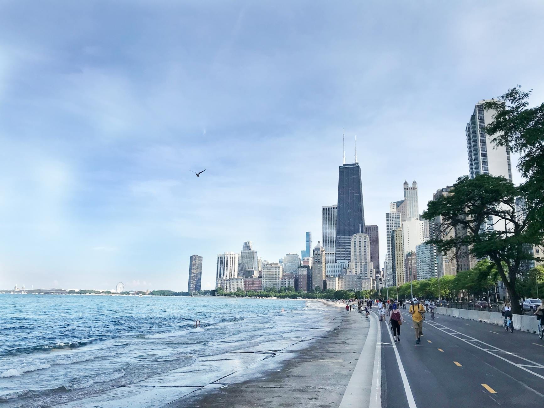
What the Lakefront Trail Actually Is
The Chicago Lakefront Trail is a paved, shared-use path running approximately 18 miles (29 km) along the Lake Michigan shoreline. It begins near Ardmore Avenue and Osterman Beach in the Edgewater neighborhood to the north and ends at 71st Street and South Shore Drive near the South Shore Cultural Center to the south. The entire length is free to use, generally open 24 hours a day, and managed by the Chicago Park District. Adjacent parks and beaches close at 11:00 PM, but the path itself stays open.
The trail is divided into dedicated pedestrian and bicycle lanes for most of its length, which reduces the friction you might expect from a path this popular. You will find walkers, joggers, cyclists, inline skaters, and the occasional skateboarder sharing the space. On summer weekends the path gets genuinely crowded between Navy Pier and Oak Street Beach, but stretches north of Montrose Avenue and south of Museum Campus thin out considerably even in peak season.
💡 Local tip
If you are walking, stay in the pedestrian lane and keep right. Cyclists move fast in the bike lane and ring bells as warnings, not greetings. Ignoring this leads to near-misses that make everyone's day worse.
What You See: The Trail Section by Section
The northern stretch from Ardmore down to Montrose passes through quieter residential lakefront, with the limestone-edged shore close to the path and the water often visible between stands of cottonwood and willow. Montrose Beach is one of the widest sandy stretches on the North Side, and the adjacent Montrose Point bird sanctuary attracts serious birders during spring and autumn migration. This section feels local rather than touristy.
From Fullerton south to Oak Street, the path passes North Avenue Beach, one of the most photographed stretches of the entire trail. The boathouse at North Avenue Beach, shaped loosely like an ocean liner, marks the point where the skyline framing becomes particularly strong. From North Avenue Beach south toward Oak Street, the skyline of the Gold Coast and the Magnificent Mile rises directly to the west while the lake opens wide to the east. On clear days, you can see the horizon where sky meets water with no land interrupting it.
The central section through Grant Park and Museum Campus is the most landmark-dense. Buckingham Fountain sits just inland. To the south, the path curves around the Museum Campus, passing within easy walking distance of the Field Museum, Shedd Aquarium, and Adler Planetarium. This segment offers some of the most dramatic city-over-water views, particularly looking north from the Adler toward the downtown skyline.
South of Museum Campus the trail continues through less visited territory: Jackson Park, the lagoons of the 1893 World's Columbian Exposition site, and eventually the South Shore Cultural Center, a grand neo-Mediterranean building set on a bluff above the lake. Fewer tourists make it this far south, but the relative solitude and the quality of the light over the lake in the afternoon make it worth the effort.
Tickets & tours
Hand-picked options from our booking partner. Prices are indicative; availability and final rates are confirmed when you complete your booking.
Chicago lakefront neighbourhood bike tour
From 18 €Instant confirmationFree cancellationGo City | Chicago All-Inclusive Pass
From 127 €Instant confirmationFree cancellationiFLY Chicago Lincoln Park indoor skydiving experience
From 126 €Instant confirmationFree cancellationiFLY Chicago Rosemont indoor skydiving tickets
From 117 €Instant confirmationFree cancellation
How the Trail Changes by Time of Day
Early mornings, particularly before 7:00 AM, belong to regulars. The air carries the clean, mineral smell of lake water without the sunscreen-and-crowd overlay that arrives later. Serious cyclists are out in pace lines. Runners nod at each other with the mutual recognition of people who got up before they had to. The skyline, backlit from the east in summer, glows orange and pink over the water in a way that disappears once the sun climbs higher.
Midday in July and August is the loudest and most crowded period, especially between Navy Pier and Museum Campus. The smell of sunscreen and grilled food from park concessions drifts across the path. Lake breezes help, but surface temperatures on the paved path can feel significantly hotter than air temperature. If you are cycling the full length, midday in summer is the least pleasant time to do it.
Late afternoons in spring and autumn are arguably the finest time on the trail. The light goes golden around 4:00 to 5:00 PM and the crowds ease. The lake in October takes on a blue-gray color that photographs do not quite capture. Wind picks up off the water, and the temperature drops faster than it does inland. Bring an extra layer even in early autumn.
Winter use is real and consistent among Chicago locals. Joggers run in all but the most extreme cold, and some cyclists ride year-round. The path can become icy after rain or light snow near the water's edge, so traction devices on running shoes are useful between December and February. The experience of a near-empty lakefront trail in February, with lake-effect snow moving horizontally across the ice shelf forming at the shore, is one of the stranger and more memorable things Chicago offers.
Getting to the Trail and Getting Around It
The trail runs parallel to Lake Shore Drive for much of its length, but the road is not easily crossed on foot everywhere. Tunnels and pedestrian bridges connect the inland neighborhoods to the lakefront at regular intervals. Key access points include the underpasses at North Avenue, Fullerton, and Belmont on the North Side, and the Monroe Street pedestrian bridge and Balbo Avenue underpass near Grant Park. Signage varies, so checking a map before you head out is worth the two minutes it takes.
CTA Red Line stations at Addison, Belmont, Fullerton, and Clark/Division put you within about a 10 to 20 minute walk of the trail on the North Side. The Green and Red Lines serve the South Side stretches. If you plan to do a one-way trip, the CTA makes car-free point-to-point runs straightforward. For a full guide to getting around the city by transit, see getting around Chicago.
Bike rentals are available through Divvy, Chicago's dock-based bikeshare system, with stations at many trail access points. Single rides and day passes are available through the Divvy app. This is the most practical way to cover a significant length of the trail without your own bike. Rental outfitters near Navy Pier and North Avenue Beach also offer hourly rentals for those who prefer a traditional bike.
⚠️ What to skip
Parking along Lake Shore Drive near the trail access points is extremely limited on summer weekends. Driving to the lakefront and expecting to find street parking near North Avenue Beach or Oak Street Beach between 10:00 AM and 4:00 PM in July or August will cost you more time than taking the train.
Seasonal Conditions and What to Expect
Chicago's humid continental climate means the trail experience varies dramatically by season. Late May through mid-June and September are the most reliably pleasant months: temperatures in the 16 to 22 °C (60 to 72 °F) range, lower humidity than July and August, and trail crowds that are active but manageable. For a broader sense of how Chicago's seasons shape what you can do outdoors, the best time to visit Chicago guide covers the full picture.
Summer brings the Chicago Air and Water Show in August, which draws enormous crowds to North Avenue Beach and the surrounding trail sections. If you are on the trail that weekend without knowing what is happening, the sudden appearance of jet noise and wall-to-wall people will answer your question. Plan around it or embrace it.
High winds off Lake Michigan are a regular feature rather than an exception. The lake generates its own local weather, and a calm day in the neighborhood can become a blustery 40 km/h headwind on the exposed lakefront path. If you are cycling northbound on a south wind day, the return trip will feel effortless. If you are cycling northbound on a north wind day in November, reconsider your route. Wind-resistant layers are useful for nine months of the year.
Photography, Accessibility, and Practical Notes
The trail offers some of the most photographed views in Chicago, but the quality of those shots depends heavily on timing and position. The skyline from just north of Museum Campus, looking northwest across Monroe Harbor, is the classic composition. It works best on clear mornings when the buildings are frontlit from the east. Midday glare off the water washes out the contrast. Overcast days with low cloud actually produce clean, evenly lit skyline shots without the harsh shadows of direct sun.
The path is paved and flat for its entire length, making it broadly accessible for wheelchair users and those with mobility aids along most sections. Some lakefront access points require navigating stairs or steep ramps, so checking your specific entry point in advance is worthwhile. The trail connects several major parks and attractions that are themselves accessible; Millennium Park and Grant Park both sit directly along the route with level access from the trail.
There are water fountains and restroom facilities at most major beach and park areas along the trail, but they are seasonal. Most facilities close in late October and reopen in late April or early May. Plan accordingly if you are walking or running long distances in the shoulder seasons. Bring water.
ℹ️ Good to know
Much of the trail has limited dedicated lighting outside of the major park areas. Night use away from the well-lit central segments near Navy Pier and Grant Park requires a headlight if you are cycling, and reasonable awareness of your surroundings if you are on foot.
Insider Tips
- The stretch between Montrose Avenue and Foster Beach on the North Side is consistently less crowded than the central section and offers equally good lake views. It is a better choice for an easy morning run than anything between North Avenue and Navy Pier on a summer weekend.
- Northerly Island, accessible from the south end of Museum Campus, sits on a small peninsula with water on three sides and almost no car noise. It is one of the quietest spots on the entire lakefront despite being steps from the main trail.
- Tailored one-way rides are easy with the CTA: start at Howard or Bryn Mawr on the Red Line, ride the trail south to Grant Park, and take the Red or Green Line back. You get a mostly downwind southward ride on most summer days and avoid retracing your route.
- The lakefront path north of Ardmore Avenue extends into Evanston with a gap, and signage at the northern terminus can be confusing. Do not expect the smooth trail surface to continue indefinitely past Osterman Beach without checking ahead.
- In autumn, the cottonwood trees along the northern sections drop seeds that look like snow and coat sections of the path in a thin layer of fluff. It is slippery underfoot when wet, and cyclists should slow down through those stretches in September and October after rain.
Who Is Lakefront Trail For?
- Runners and cyclists looking for a long, flat, scenic route with easy transit access at multiple points
- Visitors who want Chicago skyline views without paying observation deck prices
- Families with children who want beach access alongside a walkable, car-free path
- Early risers who want the city to themselves before the tourist day begins
- Budget travelers: the trail itself is free and most of the parks and beaches along it cost nothing to enter
Nearby Attractions
Combine your visit with:
- Bahá'í House of Worship
The Bahá'í House of Worship in Wilmette, Illinois, is one of the most architecturally singular buildings in North America. Free to enter, open daily, and reachable by CTA from downtown Chicago, it rewards visitors with a 135-foot lace-like dome, meditative silence, and an unusual kind of spiritual calm that transcends denomination.
- Brookfield Zoo Chicago
Brookfield Zoo Chicago is one of the largest and most historically significant zoos in the United States, covering 216 acres about 14 miles west of downtown. With more than 511 species, landmark indoor exhibits, and a genuine conservation mission, it rewards a full day of exploration. But it takes planning to get the most out of it.
- Chicago Air and Water Show
Every August, the Chicago Air and Water Show transforms the lakefront into a grandstand for one of the most spectacular free public events in the United States. Fighter jets, military demonstrations, and precision flying teams perform over Lake Michigan while hundreds of thousands of spectators line the shore from Fullerton to Oak Street.
- Chicago Botanic Garden
A living museum spread across 385 acres and nine islands north of Chicago, the Chicago Botanic Garden offers 27 gardens, four natural areas, and six miles of lake shoreline in Glencoe, Illinois. Whether you visit for a single seasonal bloom or spend a full day exploring Japanese landscapes and native prairies, this guide covers everything you need to plan a worthwhile trip.