Royal National City Park (Ekoparken): Stockholm's roughly 27 km² Urban Wilderness
The Royal National City Park, known locally as Ekoparken, is the world's first national urban park and one of Stockholm's most remarkable features. Stretching around 27 km² from Djurgården in the south to Ulriksdal in the north, it wraps around the city in a continuous arc of ancient oak forests, royal palaces, museum islands, and open waterways. Entry is free and the park never closes.
Quick Facts
- Location
- Spanning Stockholm, Solna, and Lidingö municipalities — from Djurgården and Fjäderholmarna in the south to Sörentorp and Ulriksdal in the north
- Getting There
- Tram 7 to Djurgården; buses to Gärdet, Haga, and Ulriksdal; commuter boats to Fjäderholmarna
- Time Needed
- 2 hours for a focused walk; a full day or multiple visits to cover key areas
- Cost
- Free to enter; individual attractions (museums, palaces) charge their own admission
- Best for
- Nature walks, cycling, history, photography, families, and anyone wanting open space near the city centre
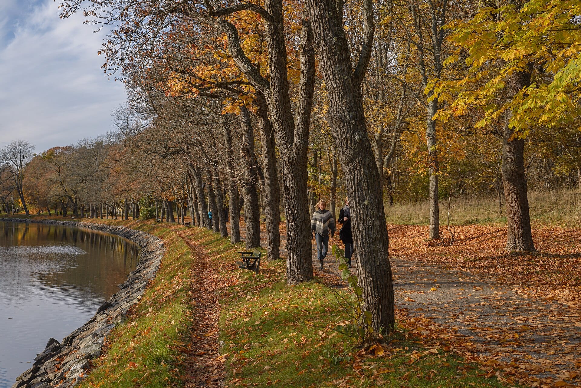
What Exactly Is Ekoparken?
The Royal National City Park, officially named Kungliga nationalstadsparken in Swedish and widely known by its original title Ekoparken, was established by the Swedish Parliament in the mid-1990s, often cited as 1994, making it the world's first national urban park. The designation was not symbolic. It carries legal protection that prevents development from fragmenting the landscape, a significant commitment in a capital city with serious real-estate pressure.
The park covers around 27 km² in total, with approximately 18 km² of land area. That footprint places it in a different category from most city parks: it is not a manicured rectangle of grass but a continuous green corridor stitching together ancient oak groves, royal estate gardens, waterfront meadows, and several of Stockholm's major cultural institutions. The southern anchor is Djurgården island and the outer island of Fjäderholmarna; the northern limit reaches Ulriksdal Palace Park and Sörentorp, in the municipality of Solna.
First-time visitors sometimes underestimate how much ground the park covers. It is best understood as a network of connected zones rather than a single destination. Djurgården is the most visited section and the logical starting point, but areas like Haga Park and Norra Djurgården reward visitors who venture further. Plan your route before you arrive.
💡 Local tip
Pick up a free park map at the Royal Djurgården Visitor Center at Djurgårdsvägen 2 by Djurgården bridge before you set off. The park's zones are spread across several bus and tram routes, and having the geography clear in your head saves significant backtracking.
The Park by Zone: What You'll Actually Find
Djurgården: The Cultural and Natural Core
Djurgården is where the park and Stockholm's major museum cluster overlap. Walking west from the Djurgårdsbroen bridge, you pass through mixed woodland and meadows within a few minutes of leaving the waterfront path. The concentration of world-class institutions here is unusual by any standard. The Vasa Museum, the Nordiska museet, and the open-air museum Skansen all sit within the park boundary, which means a cultural day and a nature walk are not mutually exclusive.
The paths along the southern shore of Djurgården are wide and paved, popular with joggers from early morning and cyclists throughout the day. The northern side of the island is quieter, with narrower trails through denser forest where you are more likely to hear woodpeckers than traffic. In spring, the apple orchards near Rosendal bloom in stages, and the air carries the kind of sweetness that is difficult to find in any other European capital this close to the city centre.
The kitchen garden at Rosendals Trädgård sits inside the park and operates as a biodynamic market garden open to visitors, with a café that sources almost entirely from the garden itself. On a weekday morning it is calm enough to find a table; weekend afternoons draw longer queues.
Haga Park: Palaces, Philosophy, and Open Meadows
Haga Park lies in the northern section of Ekoparken, across the Brunnsviken bay from Gärdet. It was designed as an English landscape garden in the late 18th century under King Gustav III and still carries that relaxed, deliberately informal character. The copper tents, the parkland around Haga Palace, and the long views across the lake give this part of the park a markedly different atmosphere from the busier Djurgården side. Hagaparken rewards a dedicated half-day visit, especially in late May when the horse chestnuts are in full bloom along the main approach path.
The Brunnsviken lake forms the spine of the park's northern section and is a area of national interest for nature conservation. In winter, when it freezes, Stockholmers skate on it. In summer, you can swim at designated spots along its banks. The contrast between those two seasonal uses captures something genuine about how locals actually relate to this park: it is functional, accessible, and deeply woven into everyday life rather than reserved for tourist itineraries.
Norra Djurgården and Gärdet: Space to Breathe
Gärdet is a broad open plain east of the city centre, one of the few genuinely flat, unobstructed green spaces within walking distance of central Stockholm. Kite-flyers, dog walkers, and people lying in the grass on summer afternoons give it the feel of a commons rather than a curated park. In the early morning it is almost entirely empty, with mist sometimes sitting low across the grass and occasional deer visible at the field margins.
Norra Djurgården, the northern extension of Djurgården island above the Djurgårdsbrunn canal, is less visited than the southern section and has several kilometers of quiet forest trail. The oak population here is among the oldest in Stockholm; some trees are estimated to be several hundred years old, and the gnarled bark and wide canopies create a scale that is simply different from younger urban greenery.
ℹ️ Good to know
The park contains over 800 ancient oak trees, one of the highest concentrations of veteran oaks in Northern Europe. These trees support rare beetle species found nowhere else in the city. The dead wood is left intentionally as habitat, so do not be surprised to see fallen trunks left in place along forest paths.
Tickets & tours
Live prices and dates from our booking partner. If you book, we may earn a commission at no extra cost to you.
2-hour archipelago tour on a RIB speedboat
From 122 €Instant confirmationFree cancellationHaunted Stockholm exploration game and tour
From 12 €Instant confirmationFree cancellationFotografiska Stockholm entrance tickets
From 0 €Instant confirmationFree cancellationStockholm: Nature Reserve Hiking Tour with Campfire Lunch
From 102 €Instant confirmationFree cancellation
How the Park Changes Through the Day and Year
The park is open 24 hours a day, every day of the year, with no gates or admission process. This means you can walk into Djurgården at 5 a.m. in mid-June and experience something close to solitude in a landscape that, by 10 a.m., will have thousands of people in it. Early mornings in summer are the most photogenic window, with low golden light filtering through the oaks and almost no one around to interrupt sightlines.
Winter visits are under-appreciated. Snow settles on the park's forest floor and open meadows in a way it cannot in the denser parts of the city, and the absence of foliage opens up views across Brunnsviken and the Djurgårdsbroen that are simply unavailable in summer. Dress for temperatures that can drop to around minus 3 to minus 8 Celsius on a cold January day, and wear waterproof footwear: the paths near the water freeze and thaw repeatedly through winter, making them unpredictable underfoot.
Autumn, specifically late September through October, brings genuinely impressive foliage. The mixture of oak, birch, and linden across the park turns in stages, and the low northern light in October creates long afternoon shadows that make the older trees look their best. If you are planning a trip around this, check the best time to visit Stockholm for a broader seasonal breakdown.
Getting to Ekoparken: Practical Routes
Because the park spans multiple municipalities and stretches roughly 12 km from south to north, there is no single entry point. How you access it depends on which section you want to explore.
- Djurgården (southern section): Tram 7 from Central Station (via Sergels torg/Kungsträdgården) to Djurgården stop. Alternatively, walk across Djurgårdsbron from Strandvägen — about 15 minutes from central Östermalm.
- Gärdet: Metro red line to Gärdet station, then walk north across the open plain.
- Haga Park: Bus routes from central Stockholm toward Solna; alight at Haga stops. Journey time roughly 20 minutes from the city centre.
- Ulriksdal Palace Park (northern tip): Commuter train to Ulriksdal station in Solna.
- Fjäderholmarna (outer islands, part of the park): Commuter boats operate seasonally from Nybrokajen and Slussen.
Cycling through the park is a serious option and arguably the best way to cover multiple zones in one day. The main paths between Djurgården, Gärdet, and Haga are well-surfaced and largely flat. Stockholm’s current bike-share schemes have stations near several park entrances. For broader orientation, the getting around Stockholm guide covers SL transport and cycling in more detail.
Cultural and Historical Significance
The land that now forms Ekoparken has been Swedish royal property for centuries. The hunting grounds and palace estates that once served the court became the park's structural backbone, which is why so many of the significant buildings within it are former royal residences or royal-commissioned structures. Haga Palace remains an official residence of the Swedish Crown Princess and her family. Ulriksdal Palace Park surrounds a 17th-century palace still occasionally used for state and royal functions. Djurgården was once a royal hunting reserve, fenced off from the public until the 19th century.
The 1994 parliamentary decision to protect this land as a national park was a direct response to development pressure. By the early 1990s, construction projects had begun to encroach on several sections of the green corridor. The designation imposed a legal framework that prohibits new construction or significant modification of the landscape without parliamentary approval, an unusually strong form of urban conservation for a capital city.
The park's status as the world's first national urban park has attracted international attention from urban planners and conservationists. It sits within a city of nearly one million people and remains ecologically functional: migratory birds use Brunnsviken as a staging area, the ancient oaks support rare insect species, and roe deer and foxes move through the forest patches at night. For visitors interested in how Stockholm approaches sustainability and urban design, this is more informative than any exhibit. The things to do in Stockholm guide places the park in the broader context of the city's outdoor culture.
Photography, Accessibility, and Practical Notes
For photography, the main variables are light and crowds. The Djurgårdsbroen bridge at sunrise offers a composition that combines water, the Nordiska museet's German Renaissance facade, and the forest behind it in a single frame, with essentially no tourists. The ancient oaks in Norra Djurgården are at their most photogenic on overcast days when the light is soft and even. The long sight lines across Gärdet work well in late afternoon on clear days when the grass catches low side-light.
Accessibility varies considerably across the park's different zones. The main paths along the southern shore of Djurgården and through the Haga parkland are wide, paved, and suitable for wheelchair users and pushchairs. Forest paths in Norra Djurgården are unpaved and uneven, with tree roots and soft ground. Several park sections have no step-free access between transport stops and the paths themselves. Always check the specific section you plan to visit if mobility is a concern.
⚠️ What to skip
Mosquitoes are present near the water and in forested areas from late May through August, sometimes in significant numbers near Brunnsviken and the Djurgårdsbroen canal. Bring repellent if you plan to walk in the evening or early morning during summer months.
There is no entry fee for the park itself. The individual museums, the Skansen open-air museum, and Gröna Lund amusement park all charge their own admission. Do not confuse free access to the parkland with free access to the institutions within it. The Stockholm Pass covers entry to several of the museums inside the park boundary.
Insider Tips
- Walk the Djurgårdsbroen bridge at 6–7 a.m. on a clear morning in June or July. The bridge, the canal, and the Nordiska museet behind it are all but empty and the light is exceptional. By 9 a.m. the same spot is full of tour groups.
- The ancient oak trail in Norra Djurgården is unmarked on most tourist maps. From Djurgårdsbrunn café, cross the small bridge and follow the unpaved path northeast through the older forest section. The density and age of the oaks is noticeably greater than the more-visited southern trails.
- Brunnsviken freezes most winters. If you visit in January or February and it has frozen solid, locals skate on it without any organized infrastructure, just a flat lake in the middle of the park. Check local conditions before you venture onto the ice.
- Rosendals Trädgård is significantly less crowded on weekday mornings than weekend afternoons. The café queue on a Saturday in July can be 30 minutes; on a Tuesday morning in the same month, you will likely walk straight in.
- The park spans three municipalities, which means some bus routes and cycling paths cross administrative boundaries without obvious signage. Download the Nationalstadsparken.se map in advance rather than relying on Google Maps, which does not always reflect which paths are open to the public versus private estate land.
Who Is Royal National City Park (Ekoparken) For?
- Walkers and joggers who want green space within cycling distance of the city centre
- Families combining a museum visit with outdoor time, particularly around Djurgården
- Photographers looking for natural light and architectural contrast without crowds, especially in early mornings
- Wildlife and nature enthusiasts interested in ancient oak ecosystems and urban biodiversity
- Visitors on a budget who want a full half-day experience with no admission cost
Nearby Attractions
Combine your visit with:
- Birka Viking Town
Founded around AD 750 on a remote island in Lake Mälaren, Birka was one of Scandinavia's earliest true urban trading centers. Today it survives as part of the UNESCO World Heritage Site Birka and Hovgården, reached only by seasonal boat from Stockholm, where around 2,000 Viking-age graves still dot the surrounding landscape. It is one of the most historically significant half-day excursions available from the Swedish capital.
- Drottningholm Palace
Drottningholm Palace is Sweden's most complete royal domain, a UNESCO World Heritage Site on Lovön island just about 10 km west of Stockholm. The baroque complex includes the palace, a working 18th-century theatre, a Chinese Pavilion, and formal gardens that shift in character across every season.
- Hagaparken
Hagaparken is a 144-hectare English landscape park just north of central Stockholm, laid out for King Gustav III in the late 18th century. Free to enter year-round, it offers a rare combination of royal history, open meadows, and waterside walking paths within easy reach of the city. Individual attractions inside the park, including the Butterfly House and royal pavilions, charge their own fees.
- Långholmen Island
Långholmen Island sits between Södermalm and Kungsholmen in central Stockholm, offering free access to beaches, walking trails, and green spaces year-round. Its most unusual feature: a functioning hotel and hostel built inside a former 19th-century prison. Entry to the island costs nothing, making it one of the most rewarding spots in the city for those who know it.
Planning a trip? Discover personalized activities with the Nomado app.