Tacchi d'Ogliastra: Sardinia's Ancient Limestone Towers
The Tacchi d'Ogliastra are a series of dolomitic limestone plateaus rising dramatically from the mountainous interior of eastern Sardinia. Free to access, steeped in Nuragic history, and crossed by trails ranging from moderate to demanding, they reward travelers willing to leave the coast behind.
Quick Facts
- Location
- Ogliastra, eastern Sardinia — across municipalities including Gairo, Ulassai, Osini, Ussassai, Jerzu, and Seui
- Getting There
- Drive from Cagliari Elmas Airport (CAG), approx. 1.5–2 hours to the Ogliastra interior; some guided tours depart from Tortolì (Piazza Fra' Locci)
- Time Needed
- Around 3 hours for a representative single trail; full day or multi-day for exploring multiple tacchi
- Cost
- Free access to the natural area; guided excursions priced on request by local operators
- Best for
- Hikers, geology enthusiasts, Nuragic history buffs, photographers
- Official website
- www.sardegnasentieri.it/en/tacchi-dogliastra
What Are the Tacchi d'Ogliastra?
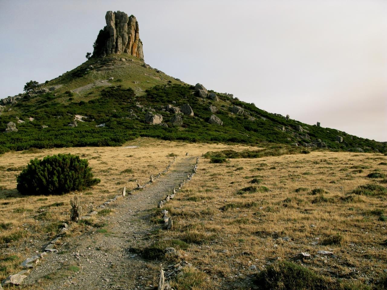
The Tacchi d'Ogliastra are a chain of isolated dolomitic limestone plateaus scattered across the mountainous interior of eastern Sardinia. Their name comes from the Sardinian word for shoe heel, and once you see them from a distance, the reference is obvious: each formation rises abruptly from the surrounding landscape, flat-topped and sheer-sided, like a boot sole lifted clean off the earth. They are not one single site but a geomorphological system spread across several municipalities, including Gairo, Ulassai, Osini, Ussassai, Jerzu, and Seui.
Geologically, the Tacchi sit on a base of Palaeozoic Silurian schists formed hundreds of millions of years ago, overlain by Mesozoic limestone deposits. The contrast between these two rock types, one ancient and crystalline, the other younger and soluble, has shaped the dramatic erosion patterns visible today: vertical cliff faces, deep gorges, and the characteristic flat summits that distinguish each taccu from its surroundings.
ℹ️ Good to know
There are no entrance gates, ticket booths, or fixed opening hours. The Tacchi d'Ogliastra are open natural terrain, freely accessible on foot. What you pay for — if anything — is a guided excursion, which many first-time visitors find worth the cost given the absence of marked signage on some routes.
The Experience on the Ground
Approaching the Tacchi by road is itself an experience. The SS389 and connecting mountain roads wind through oak and cork forests before the limestone formations suddenly appear above the treeline, pale grey against the sky. In early morning, mist sometimes sits in the valley floors while the plateau edges catch the first light — a photographic opportunity that disappears quickly once the sun rises fully.
On the trails themselves, the terrain is uneven and demands attention. Mule tracks and cart paths form the backbone of most routes, with loose limestone underfoot and occasional steep scrambles near summit areas. The silence is notable: away from the road, the dominant sounds are wind, the scuff of boots on stone, and, in spring, the calls of birds of prey that nest in the cliff faces. The air smells of wild herbs — rosemary and thyme grow from the rock crevices — and of the dry, mineral dust that rises with each footstep in summer.
One of the most recognizable formations in the system is Perda Liana, located in the municipality of Gairo. This tall, free-standing limestone tower draws hikers and is sometimes used for climbing in the wider area. It is a useful orientation point and often features in trail descriptions as a landmark or destination in itself.
Tickets & tours
Hand-picked options from our booking partner. Prices are indicative; availability and final rates are confirmed when you complete your booking.
Vineyard Guided Tour and 7 Wine Tasting in Palau
From 84 €Instant confirmationFree cancellationFull-Day Sailboat Tour in La Maddalena Archipelago from Cannigione
From 112 €Instant confirmationFree cancellationHiking excursion to the Devil's Saddle
From 35 €Instant confirmationFree cancellationExcursion to the Archaeological site of Nora
From 70 €Instant confirmationFree cancellation
History Written in Stone: Nuragic Settlements on the Tacchi
The Tacchi are not purely a geological attraction. The plateau tops and surrounding slopes contain numerous Nuragic settlements, including sites named Serbissi, Sanu, Urceni, Mela, Is Cocorronis, Pranu, and Su Samuccu. These are remnants of the Bronze Age civilization that built thousands of stone towers across Sardinia between roughly 1800 and 500 BCE. For more context on this civilization and its surviving structures across the island, the Sardinia Nuragic sites guide provides a useful overview.
The presence of Nuragic settlements on the Tacchi is no accident. The plateau edges offered natural defensive positions, visibility across the surrounding valleys, and proximity to fresh water sources below. Walking through some of these areas, you may encounter low stone walls or circular foundations half-buried in scrub vegetation. They are easy to overlook if you are not specifically looking for them, which is one reason guided tours have clear value here.
💡 Local tip
If Nuragic archaeology interests you, combine a visit to the Tacchi with the nearby archaeological heritage of Ogliastra. The region's inland villages are small and not heavily touristed, so local interaction tends to be more genuine than at larger sites.
When to Visit and How Weather Shapes the Experience
The Ogliastra interior follows a Mediterranean climate, but at elevation the temperatures are meaningfully cooler than on the coast. Summer highs in the mountains are more tolerable than the 30–38°C common at sea level, but midday heat between July and August still makes long hikes uncomfortable. The best hiking months are May, June, September, and October, when temperatures are moderate, vegetation is green, and the light is soft enough for photography. For a broader look at seasonal conditions across Sardinia, the best time to visit Sardinia guide breaks down each month.
Winter is possible but comes with risks: rain makes the limestone paths slippery, and some cart tracks become impassable. The Tacchi are rarely visited between November and March, and guided operators typically run excursions seasonally, with some tours operating on specific days from May through October only.
Thunderstorms can develop quickly over the interior in late summer afternoons, particularly in August. If you are on a plateau summit when this happens, exposure is a genuine concern. Start hikes early — by 7:00 or 8:00 AM at the latest in high summer — and plan to be off the high ground by early afternoon.
⚠️ What to skip
Do not underestimate the terrain. Most trails are rated medium difficulty (E grade in Italian hiking classifications), appropriate for people in good physical health without mobility impairments. The Tacchi are not suitable for visitors with significant mobility limitations, and trail surfaces are not wheelchair accessible.
Getting There and Practical Logistics
A private vehicle is effectively essential for reaching the Tacchi independently. The nearest international airport is Cagliari Elmas (CAG), roughly 1.5 to 2 hours by road depending on the specific trailhead. Some guided excursions organize transfers from Tortolì, the main town on the Ogliastra coast, making them a practical option for visitors without a car. For advice on navigating rural Sardinia more broadly, the getting around Sardinia guide covers car hire, road conditions, and public transport limitations.
Petrol stations in the Ogliastra interior are sparse and may have limited hours. Fill your tank before leaving the coast. Mobile phone coverage is patchy in some valley areas, so download offline maps (such as Komoot or AllTrails routes for the area) before departing. Carry more water than you think you need: there are no reliably open refreshment points on the trails themselves.
For those on organized tours, departure points are typically confirmed at the time of booking. One established pattern has groups meeting at Piazza Fra' Locci in Tortolì before being transferred by vehicle to the trailhead, with the hike itself conducted on foot under guide supervision.
Photography and What to Bring
The visual drama of the Tacchi is best captured in the first two hours after sunrise, when oblique light throws the cliff faces into sharp relief and the valleys below remain in shadow. A wide-angle lens handles the scale well, but a telephoto is useful for picking out rock formations at distance. Midday light is flat and harsh in summer, flattening the texture of the limestone.
For any visit lasting more than an hour on the trails, bring: at least 2 liters of water per person, sun protection (hat, high SPF cream), sturdy closed-toe shoes with ankle support, a light jacket for the wind on plateau edges, and a small first-aid kit. The terrain is not technically demanding by mountaineering standards, but a twisted ankle far from the road is a serious inconvenience.
The Tacchi pair naturally with other Ogliastra highlights. The sea cliffs and beaches of the Golfo di Orosei are within reach, and the gorge at Gola di Su Gorropu — one of Europe's deepest canyons — offers a complementary geology experience. For hikers interested in a serious multi-day challenge, the hiking in Sardinia guide covers long-distance routes including the Selvaggio Blu coastal path nearby.
Who Should Skip the Tacchi d'Ogliastra
If your Sardinia trip is primarily beach-focused and you have limited days, the Tacchi require a commitment: a half-day minimum once driving time is included, with no swimming at the end of it. Visitors who are not comfortable on uneven mountain paths, or who expect manicured visitor infrastructure such as paved walkways, cafes, and toilets at the site, will find the Tacchi underwhelming or actively difficult. There are no facilities on the trails.
The area is also not particularly suitable for very young children on longer routes, or for anyone with a fear of heights on the plateau edges. If you are in Ogliastra primarily for the coast, the beaches around Arbatax and Cala Gonone are easier wins.
Insider Tips
- If you visit in May or early June, the plateau meadows between the limestone formations still hold wildflowers, including orchids that disappear by July. This is the most photogenic period for ground-level detail, not just skyline drama.
- Local guides from the Ogliastra municipalities often have deeper knowledge of the Nuragic sites than generalist tour operators based in Cagliari or the coast. Ask specifically about access to the Serbissi plateau, which is one of the more archaeologically significant areas in the Tacchi system.
- The village of Ulassai has a contemporary angle worth combining with the hike: the Stazione dell'Arte museum, founded by sculptor Maria Lai who was born there, is a genuine cultural surprise in an otherwise purely natural itinerary.
- Road signs in the Ogliastra interior can be inconsistent or weathered beyond legibility. Cross-reference GPS navigation with a printed or downloaded trail map — do not rely on a single source.
- Sunrise from a taccu summit is worth a very early start, but you will need a headlamp for the approach in the dark, and ideally local knowledge of the path. This is one situation where a guide earns their fee immediately.
Who Is Tacchi d'Ogliastra For?
- Experienced hikers looking for wild, uncrowded terrain with genuine geological character
- Travelers with an interest in Nuragic and prehistoric Sardinian archaeology
- Photographers willing to be on location before 8:00 AM for quality light
- Road-trippers doing a Sardinia interior loop who want to understand the island beyond its coastline
- Visitors spending multiple days in Ogliastra who want to balance beach time with mountain exploration
Nearby Attractions
Other things to see while in Ogliastra:
- Capo Comino Dunes & Beach
A 3-kilometre stretch of white sand and wind-sculpted dunes on Sardinia's eastern coast, near Siniscola. The shallow sea, open access, and historic shipwrecks offshore make it one of the Nuoro province's most distinctive beaches.
- Grotte Su Marmuri (Ulassai)
Grotte Su Marmuri is a vast living limestone cave carved into the rocky highlands above the village of Ulassai in Ogliastra, eastern Sardinia. With chambers reaching up to around 50 metres high, active stalactite formations, and a constant interior temperature of 10°C, it offers one of the most impressive underground experiences on the island. Entry is by guided tour only, lasting approximately 1.5 hours.
- Parco Nazionale del Golfo di Orosei e del Gennargentu
Covering roughly 74,000 hectares of rugged mountain, gorge, and coastal wilderness in central-eastern Sardinia, the area commonly referred to as Gennargentu National Park is the island's most ambitious proposed protected landscape. From the island's highest peak to sheer sea cliffs dropping into the Golfo di Orosei, this is where Sardinia's raw geography is on full display.
- Punta La Marmora
At 1,834 metres, Punta La Marmora is the highest point in Sardinia and the crown of the Gennargentu massif. The hike rewards those who make the effort with panoramic views across the island's rugged interior, a genuine sense of remoteness, and a perspective on Sardinia that most visitors never see.