Spiaggia di Masua: Where Mining History Meets a Limestone Giant
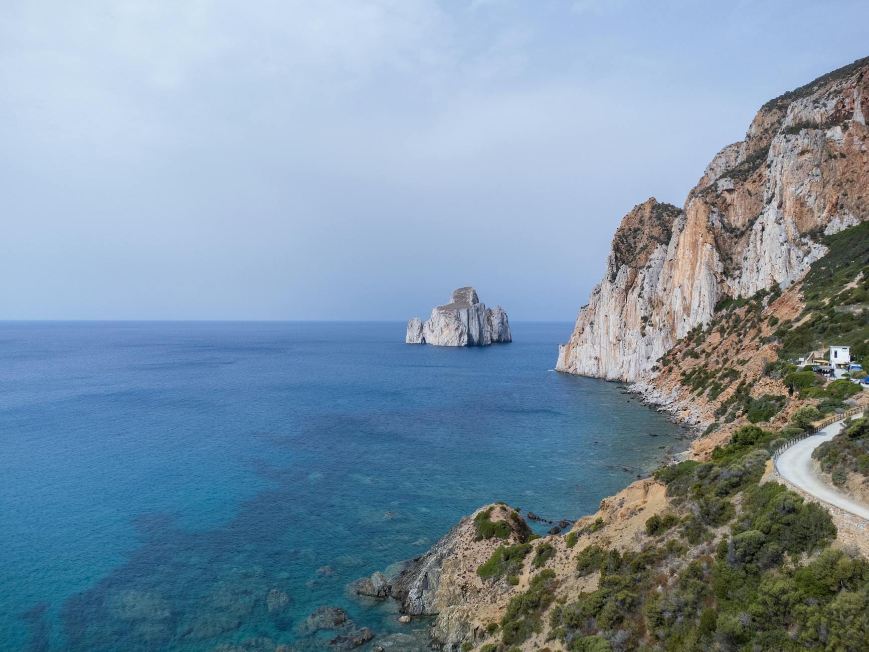
Spiaggia di Masua is a small crescent of amber-golden sand on Sardinia's southwest coast, framed by rusted mining infrastructure and dominated offshore by the Pan di Zucchero, a limestone sea stack rising about 130–133 metres above the water. The combination of industrial archaeology, dramatic geology, and clear sea makes this one of the most distinctive beaches on the island.
Quick Facts
- Location
- Frazione Masua, Comune di Iglesias, Province of South Sardinia (Sud Sardegna), southwest Sardinia — about 13 km from Iglesias town centre
- Getting There
- By car via SS130 then SP83 provincial road to the end of the road at the beach. Bus services connect to the area; boat excursions also land here. A paid car park sits close to the beach.
- Time Needed
- 2–4 hours for a beach visit; a full day if combining with Porto Flavia mine or a boat trip around the sea stacks
- Cost
- Beach access is free. Paid parking applies near the beach. Sunbed and umbrella rental available on-site at extra cost.
- Best for
- Geology enthusiasts, history-curious travellers, photographers, snorkellers, and anyone who wants a dramatic backdrop without paying resort prices
- Official website
- www.iglesiasturismo.it/spiaggia-di-masua
What Makes Masua Different from Every Other Sardinian Beach
Sardinia has no shortage of beaches with clear water and fine sand. What separates Spiaggia di Masua from the crowd is context. The moment you descend the SP83 towards the coast and the sea comes into view, the Pan di Zucchero (Sugar Loaf) fills the windscreen: a sheer limestone pillar rising roughly 130–133 metres straight out of the water, its flanks streaked white and grey against whatever the sky is doing that day. It is one of the tallest sea stacks in the Mediterranean, and it sits close enough to shore that you feel its scale from a beach towel.
Then there is the industrial layer. The beach is flanked by the skeletal remains of the Masua mining complex — a concrete pier known locally as Il Molo, a weathered warehouse, and the general atmosphere of a place that was once a working loading dock rather than a holiday destination. The mine itself was a major zinc and lead operation; at nearby Porto Flavia, completed in the 1920s, ore was transported through tunnels bored directly into the cliff face and loaded onto ships waiting offshore. That history is everywhere at Masua if you look for it, and it gives the place a texture that purely scenic beaches lack.
ℹ️ Good to know
Capacity at Masua is capped at approximately 340 people during the regulated summer season. Arriving before 9:30 am on peak July and August days is the simplest way to guarantee access and a decent spot on the sand.
The Beach Itself: Sand, Sea, and What to Expect Underfoot
The beach is small and crescent-shaped, bounded by rocks at both ends. The sand is fine and warm in tone — closer to amber than white, with occasional dark mineral specks that reflect the geological character of the whole Sulcis-Iglesiente coastline. The seabed stays mostly sandy close to shore, which makes for comfortable wading and swimming, though the water deepens relatively quickly as you move out towards the open sea.
Water clarity here is high. The absence of river mouths or agricultural runoff in the immediate area keeps visibility strong, and the rocky fringes at both ends of the beach offer straightforward snorkelling. You do not need special equipment or a guide: mask and fins are enough to see sea urchins, wrasse, and the occasional octopus tucked under the larger rocks. The water temperature becomes comfortable for swimming from around May and stays that way through October, with the warmest conditions in July and August.
On-site facilities include a bar-restaurant, toilets, a lifeguard post during the regulated season, and rental of sunbeds, umbrellas, pedalos, and kayaks. This is not a remote wild beach that requires self-sufficiency — but it is also not a resort strip. The overall feel remains low-key compared to the more developed beaches further north.
Tickets & tours
Hand-picked options from our booking partner. Prices are indicative; availability and final rates are confirmed when you complete your booking.
Vineyard Guided Tour and 7 Wine Tasting in Palau
From 84 €Instant confirmationFree cancellationFull-Day Sailboat Tour in La Maddalena Archipelago from Cannigione
From 112 €Instant confirmationFree cancellationHiking excursion to the Devil's Saddle
From 35 €Instant confirmationFree cancellationExcursion to the Archaeological site of Nora
From 70 €Instant confirmationFree cancellation
The Pan di Zucchero: Reading the Sea Stack
The Pan di Zucchero is not just a photogenic backdrop. It is a Cambrian-era limestone formation, its strata laid down more than 500 million years ago, later lifted and isolated by coastal erosion over geological timescales. The stack hosts nesting seabirds — Audouin's gulls and Eleonora's falcons have been recorded in the area — and its base is ringed by a shallow shelf that supports marine life. Boat excursions departing from Masua beach circumnavigate it, allowing a close look at sea caves and the waterline geology that you simply cannot read from shore.
In morning light, the stack catches direct sun on its eastern face and throws a strong reflection across the water towards the beach. By late afternoon, it moves into partial shadow, which actually makes it photograph better — the relief in the rock face becomes more pronounced and the silhouette against a western sky can be striking. If the mistral wind is running, the sea around the base of the stack kicks up short, steep chop that is visible even from the beach. On calm days in shoulder season, the surface is glassy enough to create near-mirror reflections.
Industrial Archaeology: The Mining Layer at Masua
Masua sits within the broader Sulcis-Iglesiente mining district, one of the most significant mineral extraction zones in the western Mediterranean. Lead, zinc, and silver were worked here since at least the Roman period, though industrial-scale operations intensified in the 19th and 20th centuries. The infrastructure you see at the beach — the pier and the warehouse — dates from that industrial era, built to handle ore shipments departing by sea. The full story of how that ore got to the water's edge involves Porto Flavia, an extraordinary cliff-face loading facility about 2 kilometres along the coast. See the Porto Flavia page for details on visiting that site, which pairs naturally with a day at Masua.
The mining settlement of Masua itself — a small cluster of buildings above the beach — was built to house workers and their families. It is now largely a quiet seasonal community, but the layout of the village still reads as a company town: functional, compact, oriented towards the industrial purpose that created it rather than towards the sea. Walking through it briefly before or after the beach adds five minutes and a layer of understanding.
For travellers with a deeper interest in the region's mining heritage, the Museo dell'Arte Mineraria in Iglesias covers the history of extraction across the entire Iglesiente area and is worth a stop on the drive back from the coast.
Timing Your Visit: How the Beach Changes Through the Day and Season
The drive down to Masua on the SP83 is itself part of the experience: the road traces limestone ridges with open views across the coast, and the descent to sea level gives a proper sense of arriving somewhere specific rather than just pulling off a coastal highway. In summer, this road can see significant traffic by mid-morning, and the small paid car park near the beach fills fast. Coming early — before 9:30 am — is not guidebook filler; at capacity, access is restricted.
July and August bring the densest crowds, though the capacity limit keeps the beach from becoming overwhelming. The shoulder months — May, June, September, and October — offer the same clear water and the same Pan di Zucchero, with far fewer people, cooler air temperatures in the morning and evening, and the possibility of having the snorkelling corners to yourself. September in particular tends to combine warm sea temperatures, calmer water than the peak summer period, and noticeably thinner crowds. October is cooler but often stable, and the low-angle light in autumn makes photography from the beach rewarding.
Winter visits are possible — the beach is publicly accessible year-round — but the bar and rental facilities close outside the main season, and sea conditions can be rough. If you are planning a broader southwest Sardinia itinerary, the September in Sardinia guide outlines why the shoulder season works well for this part of the island.
💡 Local tip
Bring your own shade if you are visiting outside the rental season or arriving early before umbrellas are set up. The beach receives full sun from mid-morning, and the surrounding cliffs offer no natural shelter.
Getting There and Getting Around
A car is the most practical option. From Iglesias, follow the SS130 and then the SP83 provincial road to Masua; the drive takes roughly 25–30 minutes. The road is well-maintained but winds considerably in the final section, so allow extra time if you are unfamiliar with Sardinian coastal roads. Parking near the beach is paid; fees vary by season and should be checked locally on arrival.
Bus services do connect to the area, though frequency is limited and schedules change seasonally — check ARST (the regional transport authority) for current timetables before planning around public transport. Boat excursions are another option: departures from Masua beach allow you to see the Pan di Zucchero and the surrounding coast from the water, which changes your understanding of the whole area significantly. For broader transport planning across Sardinia, the getting around Sardinia guide covers car hire, buses, and logistics in detail.
Masua does not have step-free confirmed access to the waterline; the paid car park reduces walking distance considerably, but official sources do not specify wheelchair accessibility. Contact the Comune di Iglesias directly for current accessibility details if this is a material consideration.
Who This Beach Is Not For
Masua is a relatively small beach with a capacity limit. Travellers expecting space to spread out across hundreds of metres of sand will find it tight during peak weeks. The surroundings, including rusted industrial structures and a former mining village rather than resort infrastructure, are part of what makes the place interesting, but visitors who want polished beach services and a manicured coastal atmosphere will likely find other Sardinian beaches more to their taste. The drive down the SP83 is not trivial; anyone without a car who is unwilling to navigate limited bus connections will find logistics challenging. And if you are specifically chasing long, empty white beaches, the southwest coast is not the right coastline.
For a broader look at the range of beach types across Sardinia, the best beaches in Sardinia guide breaks down options by character and location.
Insider Tips
- The boat excursions around the Pan di Zucchero typically depart from the beach itself; ask at the bar-restaurant on arrival about current operators and departure times, as these are not always bookable in advance online.
- The concrete pier (Il Molo) at the northern edge of the beach provides an elevated vantage point that puts the Pan di Zucchero in a different perspective from the beach-level view — it takes two minutes to walk out and makes a significant difference for photographs.
- Combining Masua with Porto Flavia on the same day requires only a short drive along the coast and makes logical sense: Porto Flavia explains the industrial infrastructure you see at the beach, and the two together give a complete picture of the Masua mining coast.
- The rocks at the southern end of the beach are less frequented than the central sandy area and offer the better snorkelling, particularly in the first hour after the beach opens when the water has not yet been disturbed.
- If you arrive to find the car park full and access restricted, the nearby area around Nebida (a few kilometres north) has its own coastal viewpoints over the same sea stacks and considerably less competition for parking.
Who Is Spiaggia di Masua For?
- Travellers who want dramatic scenery with genuine historical depth rather than a pure sun-and-sand experience
- Snorkellers and swimmers looking for clear water without paying for a boat transfer to a remote beach
- Photographers — the Pan di Zucchero provides a focal point that works at multiple times of day across all seasons
- Visitors combining a beach day with the Porto Flavia mine for a half-day of industrial archaeology
- Shoulder-season travellers (May, June, September, October) who want warm water and thin crowds simultaneously
Nearby Attractions
Other things to see while in Sulcis & the Southwest Coast:
- Carloforte (Isola di San Pietro)
Carloforte is the sole inhabited centre on Isola di San Pietro, a small island off Sardinia's southwestern coast with a strikingly un-Sardinian character. Founded in 1738 by Ligurian settlers from Tabarka, it retains its own dialect, cuisine, and urban architecture — a place that rewards slow exploration rather than quick sightseeing.
- Costa Verde
Costa Verde is a 47-kilometre arc of coastline in the Comune di Arbus, in Sardinia's southwest, running from Capo Frasca to Capo Pecora. It holds some of the most remote beaches on the island, including Piscinas, where dunes reach up to 60 metres high, making it one of the largest dune systems in Europe. There are no entry fees, minimal resort infrastructure directly on the beaches, and no public transport. That combination is exactly why it rewards visitors who make the effort to get here.
- Is Zuddas Caves (Santadi)
Carved into 530-million-year-old Cambrian dolomite beneath Monte Meana, the Is Zuddas Caves near Santadi are among the most geologically significant showcaves in Sardinia. Guided tours of a flat 500-metre route reveal towering stalactites, aragonite helictites, and chambers that once served as an alabaster quarry before local speleologists rescued them for science and tourism in 1971.
- Isola di Sant'Antioco
Sant'Antioco Island sits off Sardinia's southwest coast, connected to the mainland by a bridge over an ancient isthmus. With roots stretching back to Phoenician colonizers in the 8th century BC, it pairs serious archaeology with quiet beaches, a still-functioning fishing port, and some of the least-crowded coastline in the region.