Isola di Sant'Antioco: Sardinia's Oldest Settlement and Most Overlooked Island
Sant'Antioco Island sits off Sardinia's southwest coast, connected to the mainland by a bridge over an ancient isthmus. With roots stretching back to Phoenician colonizers in the 8th century BC, it pairs serious archaeology with quiet beaches, a still-functioning fishing port, and some of the least-crowded coastline in the region.
Quick Facts
- Location
- Off the southwest coast of Sardinia, ~87 km from Cagliari via SS126
- Getting There
- ARST buses from Cagliari; by car via SS126 across the isthmus bridge (free to cross)
- Time Needed
- 1 full day minimum; 2 days to cover beaches and archaeology comfortably
- Cost
- Free to enter the island; individual sites (museum, catacombs) charge separate fees — verify locally
- Best for
- History enthusiasts, off-season beach seekers, travellers wanting authentic Sardinian town life
- Official website
- comune.santantioco.su.it/portal/web/guest/w/luogo-sant-antioco
What Is Sant'Antioco Island, Exactly?
Isola di Sant'Antioco is the fourth-largest island in Italy after Sicily, Sardinia, and Elba, with a surface area of about 109 square kilometres. That fact surprises most visitors, who tend to think of it as a footnote on the Sardinian map. It is not. The island holds one of the oldest urban settlements in the western Mediterranean, a working town of around 10,500 people, a coastline that switches between rugged basalt cliffs and pale sand beaches, and an archaeological record that runs from Phoenician foundations in the 8th century BC straight through Roman occupation and into early Christianity.
What makes the island unusual is that it is not a day-trip showpiece dressed up for tourists. The port smells of diesel and grilled fish. Older women still practice the ancient craft of weaving sea-silk from byssus fibres harvested from date mussels. The streets of the centro storico slope upward toward a Baroque basilica that sits directly above early Christian catacombs. All of this coexists with beach bars and holiday apartments along the western coast. The combination is rare, and it rewards travellers who take time to look past the obvious.
ℹ️ Good to know
Sant'Antioco is connected to mainland Sardinia by an artificial isthmus road and a modern bridge. There is no ferry crossing needed — you drive or take a bus straight across. The ancient Romans, and before them the Phoenicians, used a similar land crossing to reach what was then called Sulci.
The Ancient City Beneath the Modern Town
The town of Sant'Antioco stands on the site of ancient Sulci (also written Sulky), one of the earliest Phoenician colonies in Sardinia, founded around the mid‑8th century BC. Carthaginian and later Roman layers built directly on top of Phoenician foundations, which is why the archaeological record here is so dense and why excavation is still ongoing in parts of the island.
The most significant Phoenician-Punic survival is the tophet, a sacred open-air sanctuary used for votive offerings, located on a hill at the edge of town. Urns containing cremated remains, both animal and human, have been excavated here in significant numbers. The site is open to visitors and is one of the most substantial examples of a Punic tophet outside of North Africa. The associated Museo Archeologico Comunale houses the finds: ceramic urns, carved stelae, bronze figurines, and imported pottery that reveals the trade networks linking Sulci to Carthage, Greece, and the Levant. Verify opening hours and admission fees directly with the museum before visiting, as they change seasonally.
If Phoenician and Punic archaeology interests you, Sant'Antioco fits naturally into a wider circuit of ancient Sardinian sites. The archaeological area at Tharros on the Sinis Peninsula and the remarkable Phoenician-era site at Tempio di Antas in the Sulcis hinterland both complement a visit here. Together they sketch a picture of Phoenician settlement patterns across Sardinia's western coast.
Tickets & tours
Hand-picked options from our booking partner. Prices are indicative; availability and final rates are confirmed when you complete your booking.
Vineyard Guided Tour and 7 Wine Tasting in Palau
From 84 €Instant confirmationFree cancellationFull-Day Sailboat Tour in La Maddalena Archipelago from Cannigione
From 112 €Instant confirmationFree cancellationHiking excursion to the Devil's Saddle
From 35 €Instant confirmationFree cancellationExcursion to the Archaeological site of Nora
From 70 €Instant confirmationFree cancellation
The Basilica and the Catacombs
The Basilica di Sant'Antioco Martire is the island's most prominent building, its pale stone facade visible from the port as you approach across the isthmus. The current structure dates largely from the late 17th and 18th centuries, but the site has been a place of Christian worship since at least the 6th century AD, and the catacombs beneath it are considerably older. The saint himself, Antioch of Sulci, was supposedly a North African Christian martyred on the island during the Roman period, and his venerated relics are kept here.
The catacombs are the real reason to descend below the basilica. They extend into the rock beneath the church and into the surrounding hillside, incorporating chambers that were originally Punic-era burial hypogea, later adapted for Christian use. Walking through the low-lit passages, you move through successive layers of Sardinian history within a single underground space. The carved niches in the tufa walls once held the dead of multiple civilisations. Guided tours of the catacombs run from inside the basilica complex; check hours and fees locally, as they operate on a seasonal schedule.
💡 Local tip
The Festa di Sant'Antioco, held in late April and early May, is one of the most significant traditional festivals in the Sulcis region. If your visit coincides with it, the town fills with processions, traditional costumes, and music that rarely make it into mainstream Sardinian tourism circuits. Check Sardegna Turismo for exact dates each year.
Beaches and Coastline: What to Expect
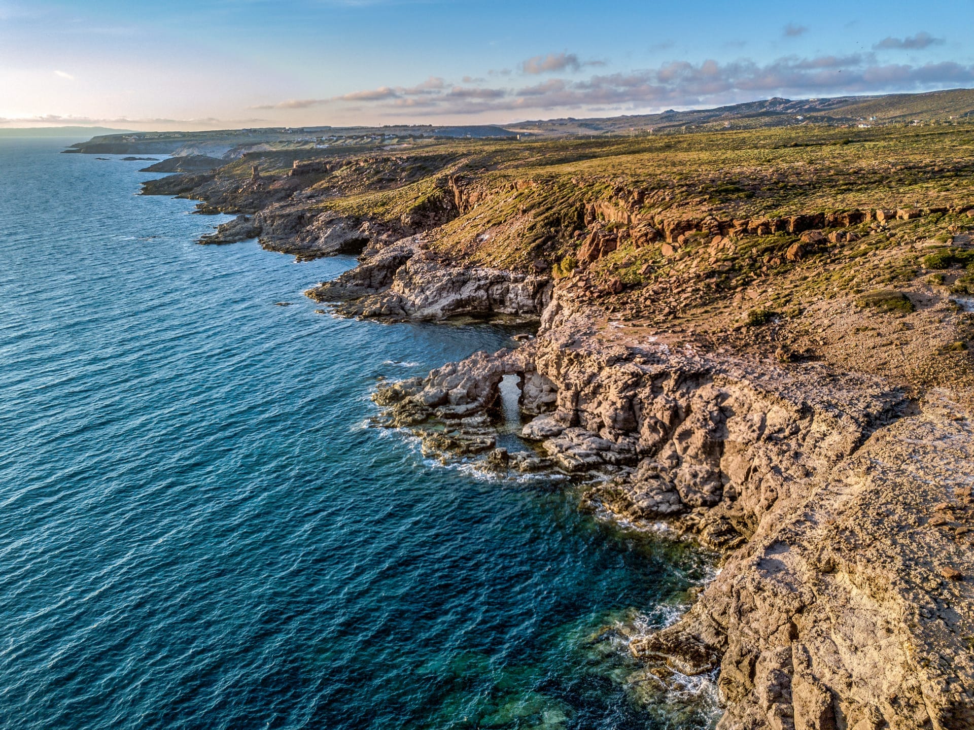
The island's coastline varies considerably depending on which direction you face. The eastern shore, facing the lagoon and the isthmus, is calm and sheltered, fringed with low vegetation and used more by locals than tourists. The western and southern coasts are where the open-sea swell of the Mediterranean hits Sardinia's continental shelf, producing longer swells and more dramatic cliff scenery.
Spiaggia Maladroxia, on the southern end of the island, is the most visited beach, with a gently sloping sandy floor and reasonably clear water. Calasetta, the small town at the northern tip of the island, has its own beach and a ferry connection to Carloforte on the island of San Pietro, making it a natural starting point for a two-island day. The northwest coast around Coaquaddus has a wilder feel: the sand is coarser, the water color deepens faster, and crowds thin out considerably even in July and August.
The southwest Sardinian coast as a whole offers consistently less crowded beaches compared to the northeast. For context on the wider coastal character of this part of the island, the Sulcis and southwest coast is one of the least commercialised stretches of Sardinian shoreline, and Sant'Antioco sits at its centre.
Weather and Swimming Season
The island shares Sardinia's Mediterranean climate: hot and dry from June through September, with sea temperatures comfortable for swimming from roughly May to October. August is the peak month for Italian domestic tourism, and even here crowds are noticeable on the main beaches. Late September and early October deliver warm days, cooler evenings, and near-empty beaches, which is the strongest argument for an off-season visit. Winter is mild by northern European standards (daytime highs typically around 14-16°C) but many beach-adjacent businesses close from November through March.
Getting Around the Island
The island is small enough that a car unlocks everything efficiently. From the bridge to the southern tip of the island takes roughly 25–30 minutes on the main road. Without a car, you are largely limited to the town of Sant'Antioco itself and whatever is reachable on foot, which includes the tophet, the basilica, the catacombs, and the port area. ARST buses connect Cagliari and other Sulcis towns to Sant'Antioco town, but service is infrequent and does not reach outlying beaches. Verify current timetables directly with ARST before planning.
The town itself is walkable. The historic centre rises steeply from the port in a grid of narrow streets, and most of the key sites are within 10-15 minutes on foot from the main piazza. The streets are paved but uneven on the upper slopes near the basilica, which is worth noting if mobility is a consideration. The isthmus bridge road is flat and smooth, and all standard road vehicles cross without issue.
If you are basing yourself in Cagliari and planning a day trip, the drive takes around 90 minutes each way on the SS126. The road passes through mining country, the rugged interior of the Sulcis-Iglesiente region, with views of abandoned mine infrastructure and dramatic highland terrain. See the day trips from Cagliari guide for route and timing details.
The Town of Sant'Antioco: Practical Walkthrough
Arriving from the bridge, the road feeds directly into the lower town and the port area, where fishing boats tie up alongside small restaurants serving grilled catch and bottarga pasta. The morning hours here have a specific rhythm: boats return, crates of fish move from dock to market, and the cafes along the waterfront fill with locals before the first tourist buses arrive. This is the best time to eat at the port, both for freshness and for atmosphere.
The main museum cluster, the tophet, and the basilica can be covered in a focused half-day. The tophet opens on the northeastern edge of town and is signposted from the main road. From there, the walk up through the centro storico to the basilica takes about 15 minutes through the kind of quiet residential streets that have resisted heavy gentrification. Afternoon light hits the upper town well for photography, particularly on the facades around the basilica.
By early evening, the port fills again for the passeggiata, the slow evening walk that is still a functional social ritual in smaller Sardinian towns rather than a performance for visitors. The restaurants cluster along the waterfront and in the streets immediately behind it. Calasetta, 14 km north, has a slightly more polished cafe scene and the added option of a late-afternoon ferry crossing to Carloforte.
⚠️ What to skip
Sant'Antioco is quiet outside July and August. In winter and early spring, some restaurants, beach facilities, and secondary attractions operate reduced hours or close entirely. If visiting outside the summer season, confirm opening status of specific sites before making the journey from Cagliari.
Is It Worth the Journey?
For travellers focused purely on beach quality, Sant'Antioco is not the strongest option in Sardinia. The beaches are decent but do not compete with the extraordinary water clarity found further north along the Golfo di Orosei or in the southwest at Chia. The real case for visiting is the combination of archaeology, town character, and coastal scenery in a single location, without the infrastructure pressure that comes with better-known destinations.
The island does not try particularly hard to attract international visitors, which is either a problem or an advantage depending on what you are looking for. Signage at archaeological sites can be limited and primarily in Italian. Menus at the simpler port restaurants may not have English translations. That authenticity is the point, but it is worth setting expectations accordingly.
Travellers drawn to Sardinia's archaeological depth will want to cross-reference a Sant'Antioco visit with the broader Sardinia nuragic and ancient sites guide, which provides context for how Sulci fits into the island's pre-Roman history alongside Nuragic monuments like Su Nuraxi di Barumini.
Insider Tips
- The tophet is more atmospheric in the hour before closing when afternoon light comes in low and the site is nearly empty. Midday visits under direct sun flatten the stonework visually and make the carved stelae harder to read.
- The ferry from Calasetta to Carloforte on San Pietro Island runs multiple times daily in summer and takes about 30 minutes. Carloforte has a distinct Ligurian-dialect heritage and a notably different culinary tradition, centred on bluefin tuna. Combining both islands makes for a rich full-day excursion.
- Ask at the local tourist office about byssus weaving demonstrations. The craft of working sea-silk from Pinna nobilis mussel fibres is one of the rarest textile traditions in the Mediterranean, and Sant'Antioco is one of the last places where it survives in any practical form.
- If you are driving, the road along the western coast toward Coaquaddus beach passes a series of unmarked pull-offs with views over the open sea toward the Sulcis hinterland. These are worth stopping for, particularly in late afternoon.
- The Museo Archeologico Comunale is small but seriously curated. Allow at least 90 minutes rather than the 45 most visitors spend. The Punic and Roman funerary objects on the upper floor provide essential context for understanding what you will see at the tophet.
Who Is Isola di Sant'Antioco For?
- History and archaeology enthusiasts who want Phoenician and Punic sites without the crowds of better-known ruins
- Travellers seeking authentic Sardinian town life away from resort infrastructure
- Off-season visitors who want Mediterranean warmth, working fishing ports, and quiet beaches
- Two-island day-trippers using the Calasetta ferry to combine Sant'Antioco with Carloforte on San Pietro
- Photographers interested in the intersection of ancient stonework, coastal light, and unreconstructed Sardinian street scenes
Nearby Attractions
Other things to see while in Sulcis & the Southwest Coast:
- Carloforte (Isola di San Pietro)
Carloforte is the sole inhabited centre on Isola di San Pietro, a small island off Sardinia's southwestern coast with a strikingly un-Sardinian character. Founded in 1738 by Ligurian settlers from Tabarka, it retains its own dialect, cuisine, and urban architecture — a place that rewards slow exploration rather than quick sightseeing.
- Costa Verde
Costa Verde is a 47-kilometre arc of coastline in the Comune di Arbus, in Sardinia's southwest, running from Capo Frasca to Capo Pecora. It holds some of the most remote beaches on the island, including Piscinas, where dunes reach up to 60 metres high, making it one of the largest dune systems in Europe. There are no entry fees, minimal resort infrastructure directly on the beaches, and no public transport. That combination is exactly why it rewards visitors who make the effort to get here.
- Is Zuddas Caves (Santadi)
Carved into 530-million-year-old Cambrian dolomite beneath Monte Meana, the Is Zuddas Caves near Santadi are among the most geologically significant showcaves in Sardinia. Guided tours of a flat 500-metre route reveal towering stalactites, aragonite helictites, and chambers that once served as an alabaster quarry before local speleologists rescued them for science and tourism in 1971.
- Museo dell'Arte Mineraria (Iglesias)
Housed in a 1911 Liberty-style technical institute and extending into a real underground training mine, the Museo dell'Arte Mineraria in Iglesias preserves the tools, machinery, and human story of Sardinia's centuries-old mineral industry. It is one of the few places in Europe where you can walk through actual mine tunnels beneath a working school building.