Tharros Archaeological Site: Phoenician, Punic, and Roman Ruins on the Sinis Peninsula
Perched on the Capo San Marco peninsula at the tip of the Sinis Peninsula, the Tharros Archaeological Site layers nearly three thousand years of history across a narrow headland above one of Sardinia's most photogenic stretches of coastline. Phoenician foundations, Punic streets, Roman columns, and pre-Nuragic traces share the same exposed rock — all with the Gulf of Oristano glittering on both sides.
Quick Facts
- Location
- Loc. San Giovanni di Sinis, 09072 Cabras (OR), Sinis Peninsula, Sardinia
- Getting There
- Car from Oristano (~23 km, ~25 min). A seasonal Tharros train service connects the site to San Giovanni di Sinis church and nearby beaches — check Mont'e Prama for current timetable.
- Time Needed
- 2–3 hours for a thorough visit; allow an extra hour if combining with the nearby Torre di San Giovanni or Sinis beaches
- Cost
- Paid admission; ticket types and current prices vary by season and eligibility — verify at monteprama.it before visiting. Free or reduced entry is available for visitors with disabilities and one caregiver; check current policy before visiting.
- Best for
- Ancient history enthusiasts, photographers, travellers who want archaeology with a coastal backdrop
What Tharros Actually Is
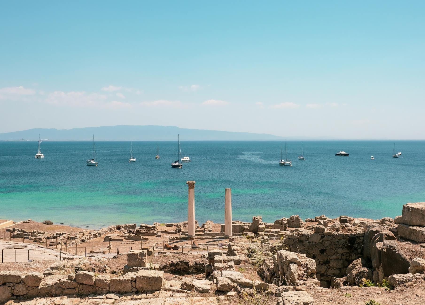
The Tharros Archaeological Site occupies the narrow Capo San Marco promontory at the southern tip of the Sinis Peninsula, where the land tapers to a finger of pale limestone above the Gulf of Oristano. The site is not a single-period ruin: it is a palimpsest of occupation stretching from the Nuragic Bronze Age through Phoenician settlement (traditionally dated to the 8th century BC but recent research suggests a foundation in the late 7th century BC), Punic urbanisation, Roman expansion, and eventual medieval abandonment. On a clear morning you can stand between two Roman columns still standing upright and see sea on three sides. It is one of the few places in Sardinia where you can trace the full arc from prehistoric to classical civilisation within a single walk.
Tharros is managed under the Mont'e Prama archaeological and natural park network, which also encompasses the extraordinary Giants of Monte Prama statues discovered nearby. Together they form the interpretive core of a region that is quietly one of the richest archaeological zones in the Mediterranean.
💡 Local tip
Arrive before 10:00, especially in July and August. The peninsula is fully exposed to the sun and offers almost no shade. By mid-morning the heat radiating off the pale stone can be punishing, and coach groups begin arriving from Oristano around 10:30.
The Layered History of the Site
The oldest visible traces at Tharros predate the Phoenician arrival. Nuragic-period remains, including a tophet (sacred precinct) and traces of earlier settlement, have been identified across the headland, pointing to continuous human use of this strategic coastal position well before the end of the 2nd millennium BC. The Phoenicians who established a trading colony here — probably in the 9th or 8th century BC — chose the location for the same reasons sailors have always chosen it: two natural anchorages, one on each side of the promontory, and clear sightlines across the gulf.
Under Punic rule, Tharros developed into a proper city with a street grid, sanctuaries, and industrial quarter. Much of what is visible today at ground level belongs to this Punic-Roman transition: the paved cardo and decumanus (the main axes of the Roman street plan), baths, a small temple precinct, and the base foundations of earlier Punic structures beneath them. The Romans absorbed and rebuilt rather than erased, which is why the archaeology here reads as layers rather than chapters.
By the early medieval period the site was being gradually abandoned, with the population relocating to what is now Oristano. Tharros saw increasing antiquarian and archaeological interest from the 19th century onward, and systematic excavation — still ongoing in parts — has been conducted since then. What you see today is a partially excavated city: significant sections remain underground, and new finds continue to reshape the interpretation of the site.
Tickets & tours
Hand-picked options from our booking partner. Prices are indicative; availability and final rates are confirmed when you complete your booking.
Excursion to the Archaeological site of Nora
From 70 €Instant confirmationFree cancellationGuided tour of Nora archaeological site from Cagliari
From 90 €Instant confirmationFree cancellationGuided tour through historical and archaeological sites of Olbia
From 78 €Instant confirmationFree cancellationSmall Group Tour to Su Nuraxi Unesco Site From Cagliari
From 90 €Instant confirmationFree cancellation
Walking the Site: What You Will See
The entrance is near the church of San Giovanni di Sinis, a small early Christian building that itself contains architectural fragments from the Roman-era city — you pass it before reaching the ticket office, and it is worth pausing here. The church's rough basalt walls and worn threshold set the tone: this peninsula has been repurposed continuously for three thousand years.
Once inside the site, the most immediately legible structures are Roman-era. Two Corinthian columns rise from what was a temple podium near the highest point of the headland, and these are the image most associated with Tharros in travel photography. The columns are photogenic precisely because the backdrop is open sea, but they also mark the civic and religious heart of the Roman city. From here, the paved Roman street descends northward, flanked by the foundations of domestic and commercial buildings. The stone surface is grooved from centuries of cart traffic — run your foot along it and the wear is unmistakable.
Lower on the slope, the baths complex is one of the better-preserved sections. You can identify the hypocaust system — the raised floor that allowed hot air to circulate beneath — in several rooms. The scale is modest compared to mainland Roman baths, but the survival of the tile work and the opus signinum (waterproof cement) lining makes this a technically interesting area for anyone who wants to understand Roman construction in detail.
The tophet, the Phoenician-Punic sacred enclosure where votive urns were buried, is on the northern side of the site. The urns themselves are now in the Museo Civico di Cabras and the national museum in Cagliari, but the precinct itself is visible. Interpretive panels at the site explain the long-debated function of tophets across the Phoenician world. Across the site, signage is bilingual in Italian and English, though some panels are worn and could be clearer.
How the Experience Changes Through the Day
Early morning, roughly 09:00 to 10:00, is the best window. The light is low and angled from the east, which means the texture of the cut stones and the ruts in the paved streets are sharply defined. The Gulf of Oristano has a still, glassy quality at this hour, and the site feels surprisingly intimate with just a few other visitors. The smell here in the early hours is salt, dry thyme, and warm limestone — the kind of specific sensory combination that makes a place stick in memory.
From 10:30 onward the dynamic shifts. Tour groups with guides arrive from Oristano and Cabras, the sun climbs above the headland, and the exposed paths between ruins become hot underfoot. The Roman columns, which glow amber in morning light, flatten to a bleached white by midday. If you arrive mid-morning, bring water and a hat — the site has no shade structures, no café on-site, and the nearest refreshment point is back near the San Giovanni church and the small beach parking area.
Late afternoon visits in shoulder season (May, September, October) are a second strong option. The light returns to warm and directional after around 17:00, the crowds have thinned, and the temperature drops to something comfortable. In summer, however, note that the site closes at 20:00 (last admission 19:15) in June, July, and August, so a late-afternoon arrival is feasible but give yourself at least 90 minutes to see the main areas properly.
Getting There and Practical Logistics
The site sits roughly 23 kilometres southwest of Oristano, accessed via the SP6 through the flat Sinis Peninsula landscape. By car the drive takes around 25 minutes from Oristano via the SP6. The road passes through Cabras — which has fuel stations, a supermarket, and the Museo Civico di Cabras where the Giants of Monte Prama are now displayed — and then continues through a flat, reedy landscape of lagoons before the peninsula narrows toward San Giovanni di Sinis and Capo San Marco.
There is a parking area near the church of San Giovanni di Sinis. A seasonal Tharros train service (a small tourist road train rather than a railway) links the parking area and church to the archaeological site entrance and to the Sinis beaches. Check the Mont'e Prama website for current operating days and times. Public bus connections from Oristano exist via ARST regional services (for example line 430 to San Giovanni di Sinis) but are infrequent — this is one of the sites in the Oristano and Sinis Peninsula area where having a car or joining an organised tour makes a significant practical difference.
Opening hours vary by season and typically follow a 09:00 opening with closing times between 17:00 and 20:00 depending on the month, with closures on Mondays in the low season; check the Mont'e Prama or official Tharros page for the current detailed timetable. These hours are correct as published by Mont'e Prama but should be confirmed directly before travel, as seasonal adjustments are common.
⚠️ What to skip
The site is entirely outdoors on exposed limestone. In summer, temperatures on the headland can exceed 35°C by midday. Bring at least 1.5 litres of water per person, sun protection, and closed-toe shoes with grip — some path surfaces are uneven and slippery where the stone is polished.
Photography, Accessibility, and Honest Limitations
The two standing Roman columns are the postcard image of Tharros, and they photograph best in the hour after opening when the angle of light hits the carved capitals directly. A standard 24–70mm lens covers the main compositions well; the columns with the sea behind them work at 35mm from the raised path to the west of the temple podium. The paved Roman street with its worn ruts photographs well with a wide lens at ground level, especially when the light is raking and directional.
On accessibility: the terrain at Tharros is uneven throughout. The main paths are compacted earth and stone, with sections of ancient paved road that are irregular underfoot. Wheelchair access across the full site is limited by the terrain itself, and visitors with significant mobility impairments may find large portions of the route difficult. Mont'e Prama does offer free admission for visitors with disabilities and one accompanying caregiver, but the physical layout of the site is the practical constraint. Contact Mont'e Prama directly if you have specific accessibility requirements.
A note on expectations: Tharros is significant, but it requires some archaeological imagination. Unlike sites with standing structures, colonnaded streets, or preserved mosaics, much of what you walk through is at foundation level. Visitors who struggle to read ruined foundations without visual reconstruction aids may find the experience underwhelming unless they prepare in advance. Reading about the site's history beforehand, or visiting the Museo Civico di Cabras to see the artefacts recovered from Tharros before the site visit, transforms the experience. The Giants of Monte Prama in the Cabras museum — colossal Nuragic stone warrior figures found a few kilometres from Tharros — provide essential context for understanding the world that preceded the Phoenician city. See our guide to Sardinia's Nuragic sites for broader context on how Tharros fits into the island's prehistoric landscape.
Combining Tharros With the Wider Sinis Peninsula
The Sinis Peninsula rewards a full day rather than a two-hour stop. The Stagno di Cabras lagoon, visible on the drive out, supports flamingos and a significant mullet fishery — the grey mullet roe (bottarga di muggine) produced here is among the most prized in Italy. The beach at Is Arutas, a few kilometres north of San Giovanni di Sinis, is composed of rounded quartz grains rather than sand, giving it an almost polished appearance unusual even by Sardinian standards.
For those planning a wider itinerary, Tharros is a natural inclusion in a day trip from Cagliari (approximately 100 km north via the SS131, around 90 minutes), though combining it with Cabras, the lagoon, and an Arutas beach stop makes for a full day. Oristano itself, 20 kilometres east, has a good selection of restaurants for a post-visit lunch — a more comfortable option than eating near the site.
Insider Tips
- Visit the Museo Civico di Cabras before the archaeological site, not after. The artefacts from Tharros — including jewellery, ceramics, and the context for the Giants of Monte Prama — give the ruins meaning. Without this preparation, many visitors are left reading worn panels over stone foundations.
- The Torre di San Giovanni di Sinis, a Spanish coastal watchtower at the southern tip of the promontory near the site entrance, offers the single best elevated view over the whole Capo San Marco peninsula. It takes five minutes to walk to and is often overlooked by visitors who head straight into the paid site.
- In June and September, the low-angle afternoon light from around 17:30 onward makes the colour of the Gulf of Oristano a deep cobalt and brings out the honey tones in the limestone columns. These are better shooting conditions than morning if you are coming from the south and find the early slot impractical.
- If you are driving, fill your fuel tank before leaving Cabras for the site. There are no services on the peninsula beyond the parking area and a small seasonal bar. The road back to Oristano passes through Cabras, which has everything you need.
- November to March visits are quiet, and the site is closed on Mondays in the low season. Weekday visits in April or October offer the closest thing to having the headland to yourself — the light is good, temperatures are comfortable, and the crowds simply do not exist.
Who Is Tharros Archaeological Site For?
- Travellers with a serious interest in Phoenician, Punic, or Roman history who want to see Mediterranean civilisation layered in one place
- Photographers who want classical ruins with a dramatic coastal backdrop and no modern intrusions in the frame
- Those already spending time in the Oristano area who want to combine archaeology with the unique Sinis Peninsula landscape
- Families with older children (10+) who can handle uneven terrain, a couple of hours of walking in the sun, and some context-reading
- Itinerary planners building a broader Sardinian archaeology day alongside the Giants of Monte Prama and the Cabras museum
Nearby Attractions
Other things to see while in Oristano & the Sinis Peninsula:
- Giants of Mont'e Prama (Cabras Museum)
The Giants of Mont'e Prama are Nuragic stone statues discovered near Cabras in 1974 — carved warriors, archers, and boxers currently dated to roughly 900–750 BCE. Displayed at the Civic Archaeological Museum “Giovanni Marongiu” in Cabras (with additional sculptures in Cagliari), they represent one of the most significant archaeological finds in the entire Mediterranean world.
- Lago Omodeo
Lago Omodeo is the largest artificial reservoir in Sardinia, formed by damming the Tirso River and stretching almost 30 km² across the central-western interior of the island. Its layered history, from a record-breaking 1924 dam to a torpedo attack in 1941 to a 100-metre replacement inaugurated in 1997, makes it far more than a scenic viewpoint. Entry is free, access requires a car, and the reward is a landscape that most coastal-focused visitors never see.
- Nuraghe Losa
Standing on the basalt plateau of Abbasanta in central-western Sardinia, Nuraghe Losa is a remarkably well-preserved trilobed nuraghe dating back to the 14th century BC. With its massive central tower, three surrounding bastions, and a sprawling village complex covering 3.5 hectares, this is one of the most complete and legible Nuragic sites on the island — and one of the few that rewards visitors who take the time to climb inside.
- Pozzo Sacro di Santa Cristina
The Pozzo Sacro di Santa Cristina, near Paulilatino in the Oristano province, is one of the best-preserved sacred wells of the Nuragic civilization, dating to around the 11th century BC. Its keyhole-shaped staircase descends into the earth with architectural precision that still puzzles researchers. This is not a site you pass through quickly — it rewards slow attention.