Lago Omodeo: Sardinia's Inland Sea and the Dam That Changed an Island
Lago Omodeo is the largest artificial reservoir in Sardinia, formed by damming the Tirso River and stretching almost 30 km² across the central-western interior of the island. Its layered history, from a record-breaking 1924 dam to a torpedo attack in 1941 to a 100-metre replacement inaugurated in 1997, makes it far more than a scenic viewpoint. Entry is free, access requires a car, and the reward is a landscape that most coastal-focused visitors never see.
Quick Facts
- Location
- Province of Oristano, central Sardinia (main postal address: 09080 Bidonì)
- Getting There
- Car only. From Cagliari take SS 131 north, exit at Paulilatino, continue to Busachi. From Sassari take SS 131 south, exit at Abbasanta, head toward Fordongianus then Busachi. Final tracks to the lake are unsigned.
- Time Needed
- 1.5 to 3 hours for a viewpoint circuit; half a day if combining with Fordongianus or nearby nuraghi
- Cost
- Free. No admission fee for the lake and viewpoints. Organised tours charged separately by private operators.
- Best for
- Landscape photography, off-the-beaten-path explorers, history enthusiasts, road-trippers
- Official website
- www.sardegnaturismo.it/en/explore/omodeo
What Lago Omodeo Actually Is
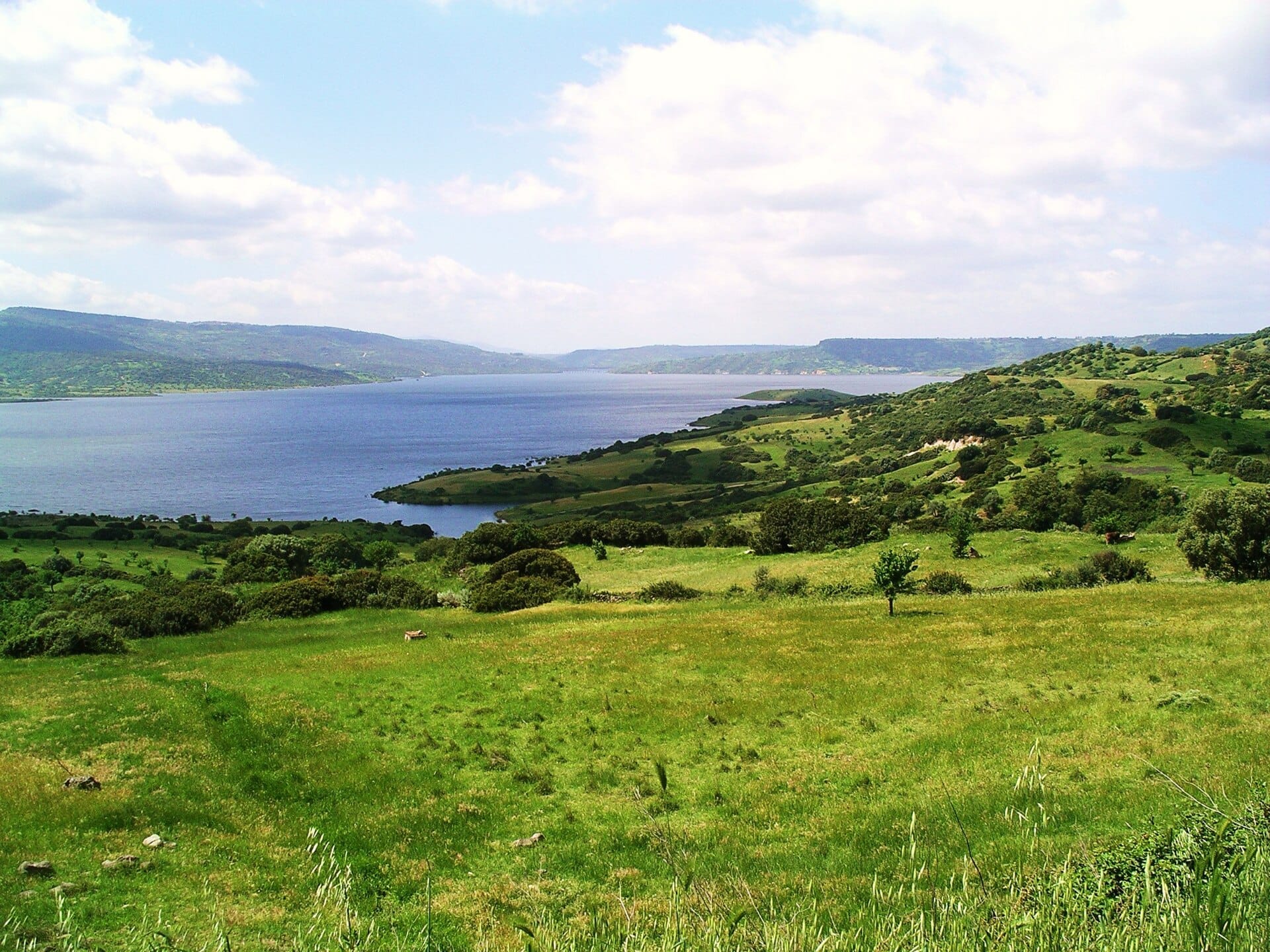
Lago Omodeo is an artificial reservoir created by damming the Tirso River, the longest river entirely within Sardinia. It stretches for approximately 20 kilometres and covers about 29 square kilometres, making it the largest artificial lake on the island. It sits across eleven municipalities in the Province of Oristano, in the island's largely overlooked interior plateau.
This is not a manicured attraction with ticket booths and signposted trails. The lake exists at the scale of a geographic feature, and you experience it as such: from hillside roads, from the edge of small villages, or from viewpoints that require asking a local which unmarked track to take. That quality is precisely what draws the kind of traveller who finds Sardinia's coasts too crowded and too familiar.
⚠️ What to skip
The final access tracks from Busachi to the lake's best viewpoints are not signposted. Download an offline map before you go, or ask at a bar in Busachi for directions. GPS alone may route you down an unsuitable track.
A Century of Engineering History
The lake's origins are rooted in one of early 20th-century Italy's most ambitious civil engineering projects. The original Santa Chiara dam, designed by engineer Angelo Omodeo (after whom the lake was later named), was inaugurated in 1924 by King Victor Emmanuel III. At the time of its completion, it was the largest reservoir in Europe, a remarkable achievement for an island that had long struggled with water scarcity and agricultural productivity.
The dam's wartime chapter adds a darker layer to its story. In 1941, during World War II, British aircraft attacked the structure with aerial torpedoes, one of the more unusual military engagements to occur on Italian soil during that conflict. The dam survived, but the episode left its mark on local memory.
Decades later, the infrastructure was comprehensively rebuilt. A new dam, named after Eleonora d'Arborea, the medieval Sardinian jurist and ruler who codified island law in the 14th century, was constructed over 15 years and inaugurated in 1997. Standing approximately 100 metres high and 582 metres long, the new structure partly submerged the original 1924 dam. If you look carefully from elevated viewpoints during lower water periods, the ghostly outline of the older structure can sometimes still be detected beneath the surface.
That layering of history, a 1924 record-breaker, a wartime torpedo attack, a 1997 replacement, reflects the broader Sardinian experience of ancient landscapes reshaped by modern intervention. Visitors interested in the island's archaeological and engineering heritage will find the lake pairs well with sites like the Tharros archaeological site on the Sinis Peninsula or the nuragic complex at Su Nuraxi di Barumini to the south.
Tickets & tours
Hand-picked options from our booking partner. Prices are indicative; availability and final rates are confirmed when you complete your booking.
Full-Day Sailboat Tour in La Maddalena Archipelago from Cannigione
From 112 €Instant confirmationFree cancellationCatamaran tour in La Maddalena archipelago with lunch
From 137 €Instant confirmationFree cancellationFull-Day Catamaran Tour to La Maddalena Archipelago with Lunch
From 118 €Instant confirmationFree cancellationBoat Tour in the La Maddalena Archipelago From Palau
From 131 €Instant confirmationFree cancellation
What It Looks and Feels Like
The first view of Lago Omodeo from a hilltop road is arresting. The water is an intense blue-green, deepened by the surrounding ochre and limestone terrain, and the lake's irregular shoreline creates peninsulas and inlets that make it look, at a distance, more like a natural fjord than a reservoir. There are no beach bars, no boats for hire, no parasols. The silence is substantial.
In the early morning, particularly from late spring through early autumn, a light mist often sits on the water's surface, softening the reflections of the surrounding hills. By mid-morning the mist burns off and the colours become sharper and more photogenic. Late afternoon, when the sun drops toward the western hills and the water turns gold and copper, is when the landscape is most dramatic for photography.
The air in this part of Sardinia carries the smell of wild thyme, rockrose, and dry grass, a drier, scrubier scent than the coastal areas. Cicadas are loud in summer. In spring, the hillsides around the lake are covered in wildflowers, including asphodels and orchids that are surprising given the arid-looking terrain. You are unlikely to see many other visitors; the lake is significant in scale but small in tourism footprint.
💡 Local tip
Early morning in May or September offers the best combination of cool temperatures, mist effects on the water, and wildflowers or autumn colour in the surrounding scrubland. Summer midday heat can be punishing in this treeless interior landscape.
How the Lake Changes by Season
Water levels fluctuate noticeably across the year. Summer drawdowns, when water is used for agriculture and regional supply, can expose broad bands of pale limestone around the shoreline, creating a bleached ring that makes the lake look slightly depleted. The landscape is still striking, but it reads differently from the full winter reservoir, which reaches higher into the valleys and covers more of the surrounding rock. If you want the fullest, most saturated impression of the lake, late winter or spring, after seasonal rains, is the better time.
Winter visits are quieter still. The interior plateau can be cold by Sardinian standards, with temperatures dropping to single digits at night and occasional frost on higher ground. Rain is possible from November through March. But the low winter light on the water is exceptional for photography, and the complete absence of other visitors makes the place feel remote.
For a general sense of when to plan your trip to Sardinia's interior, the best time to visit Sardinia guide covers seasonal patterns across the island, though note that inland conditions differ from the coast.
Getting There and Navigating the Area
A private car is essential. There is no practical public transport to the lake's viewpoints. The SS 131, Sardinia's main north-south artery (and notably, the island has no motorways), is your access spine from either Cagliari to the south or Sassari to the north.
From Cagliari, the drive takes roughly 90 minutes. Exit the SS 131 near Paulilatino, then follow provincial roads toward Busachi, a small hilltop village that serves as the most useful staging point. From Busachi, tracks lead down toward the lake's shoreline and viewpoints, but these are not signposted. The village is worth a brief stop on its own account: the historic centre has a quiet, preserved quality typical of the Oristano interior.
From Sassari, exit at Abbasanta and head through Fordongianus, a Roman-era town with thermal baths that is worth a stop in its own right. The road continues to Busachi and the lake. Allow 2 to 2.5 hours from Sassari.
If you are building a broader itinerary around central Sardinia, the lake fits naturally into a Sardinia road trip that connects the Oristano coast with the Barbagia highlands to the east.
ℹ️ Good to know
The lake spans eleven municipalities. Bidonì is often cited as a reference address for mapping purposes, but you may approach the lake from several different directions depending on which viewpoint you are targeting. The village of Busachi is the most commonly used base.
Practical Considerations: What to Bring and What to Expect
Because this is an open landscape rather than a managed site, there are no facilities at the lake itself: no toilets, no cafes, no shade structures. Stock up on water and food in Busachi or another nearby village before heading down to the water. In summer, the interior plateau reaches temperatures that exceed 35°C by mid-afternoon, and the exposed shoreline offers no relief.
Footwear with grip is useful if you plan to walk along the rocky shoreline. The terrain is not technically demanding, but the combination of loose limestone and irregular surfaces makes sandals a poor choice. A hat and sunscreen are essential from May through September.
Photography is excellent throughout the day but peaks at the golden hours. A wide-angle lens handles the scale of the lake well, and a polarising filter significantly improves the water's colour rendering. The elevated road sections above Busachi provide wide views without requiring any hiking.
Wheelchair accessibility cannot be confirmed at this time. No official source details paved or adapted viewing platforms at the lake. Visitors with mobility needs should contact the tourist offices of nearby municipalities directly before making the trip.
Is Lago Omodeo Worth Your Time?
In short, depends on what you are looking for. If you are making a short trip to Sardinia focused on beaches and coastal towns, Lago Omodeo will likely not compete for your limited days. The access requires effort, the site is entirely unserviced, and the experience is quiet to the point of solitude.
But for travellers with more than a week on the island, or those specifically drawn to inland Sardinia's different character, the lake is rewarding. The scale of the reservoir is unexpected given how little it appears in travel coverage of Sardinia. The historical depth, a dam that was once a continental record-holder, attacked during a world war, replaced by a structure named after a medieval Sardinian heroine, gives it a narrative that coastal scenery rarely has.
Travellers who enjoy this kind of inland, culturally textured exploration often also respond well to the political murals of Orgosolo to the east, or the Giara di Gesturi plateau to the southeast, where wild ponies still roam an ancient basalt tableland. These three sites together form a compelling route through Sardinia's interior that most visitors never take.
Insider Tips
- Ask at a bar or shop in Busachi for the current best track to the lake. Locals know which routes are passable and which have washed out, and they are used to occasional visitors asking. A few words of Italian help, but gestures and a map on your phone will get the job done.
- During lower water periods, the outline of the original 1924 Santa Chiara dam can sometimes be seen beneath the surface near the newer structure. Bring binoculars if you are interested in spotting it.
- The hilltop town of Busachi is known for its traditional textile weaving. The village has small workshops producing locally woven textiles in patterns specific to this part of Oristano province. It is worth 20 minutes of your time before or after the lake.
- Fordongianus, on the road from Abbasanta to Busachi, has Roman thermal baths directly on the Tirso River, the same river dammed to create the lake. The site is modest but adds genuine historical context to the visit and has properly maintained facilities.
- If you are combining this with an overnight stay in the Oristano area, consider basing yourself in Oristano town rather than a coastal resort. The drive to the lake is straightforward from there, and you avoid the coastal premium prices.
Who Is Lago Omodeo For?
- Road-trippers building a cross-island itinerary away from the coast
- Landscape and nature photographers seeking non-coastal Sardinian scenery
- History enthusiasts interested in 20th-century civil engineering and wartime Sardinia
- Travellers on a second or third visit to Sardinia who already know the beaches
- Anyone specifically exploring the Oristano province and its less-visited interior
Nearby Attractions
Other things to see while in Oristano & the Sinis Peninsula:
- Giants of Mont'e Prama (Cabras Museum)
The Giants of Mont'e Prama are Nuragic stone statues discovered near Cabras in 1974 — carved warriors, archers, and boxers currently dated to roughly 900–750 BCE. Displayed at the Civic Archaeological Museum “Giovanni Marongiu” in Cabras (with additional sculptures in Cagliari), they represent one of the most significant archaeological finds in the entire Mediterranean world.
- Nuraghe Losa
Standing on the basalt plateau of Abbasanta in central-western Sardinia, Nuraghe Losa is a remarkably well-preserved trilobed nuraghe dating back to the 14th century BC. With its massive central tower, three surrounding bastions, and a sprawling village complex covering 3.5 hectares, this is one of the most complete and legible Nuragic sites on the island — and one of the few that rewards visitors who take the time to climb inside.
- Pozzo Sacro di Santa Cristina
The Pozzo Sacro di Santa Cristina, near Paulilatino in the Oristano province, is one of the best-preserved sacred wells of the Nuragic civilization, dating to around the 11th century BC. Its keyhole-shaped staircase descends into the earth with architectural precision that still puzzles researchers. This is not a site you pass through quickly — it rewards slow attention.
- Spiaggia di Is Arutas
Spiaggia di Is Arutas is a protected crescent beach on Sardinia's Sinis Peninsula where the shoreline is composed of tiny rounded quartz grains in shades of white, pink, and grey — not conventional sand. Access is free, but strict environmental rules apply. A car is almost essential to get here.