Porto Flavia: Inside Sardinia's Extraordinary Cliffside Mining Port
Porto Flavia is a feat of early 20th-century industrial engineering carved directly into the cliffs above the Tyrrhenian Sea near Masua, southwest Sardinia. Built in 1924 to load ore from local mines onto cargo ships below, its twin tunnels and sea-facing loading bay are now accessible by guided tour, offering a rare combination of industrial history and dramatic coastal scenery.
Quick Facts
- Location
- Masua, in the comune of Iglesias near Nebida, Sulcis-Iglesiente, southwest Sardinia
- Getting There
- By car via SS130 to Iglesias, then SS126 and SP83 toward Masua (parking on site, ~200 m walk to ticket office). By public transit: train to Iglesias, then bus 808 to Masua.
- Time Needed
- Allow 1.5–2 hours including the guided tour (~50 minutes) and time to explore the cliff viewpoints
- Cost
- Full €13 | Reduced €8 (children 6–12, seniors 65+) | Groups €10 | Guided tour included
- Best for
- Industrial history enthusiasts, geology lovers, photography, couples, curious travelers
- Official website
- www.iglesiasturismo.it/en/porto-flavia-eng
What Porto Flavia Actually Is
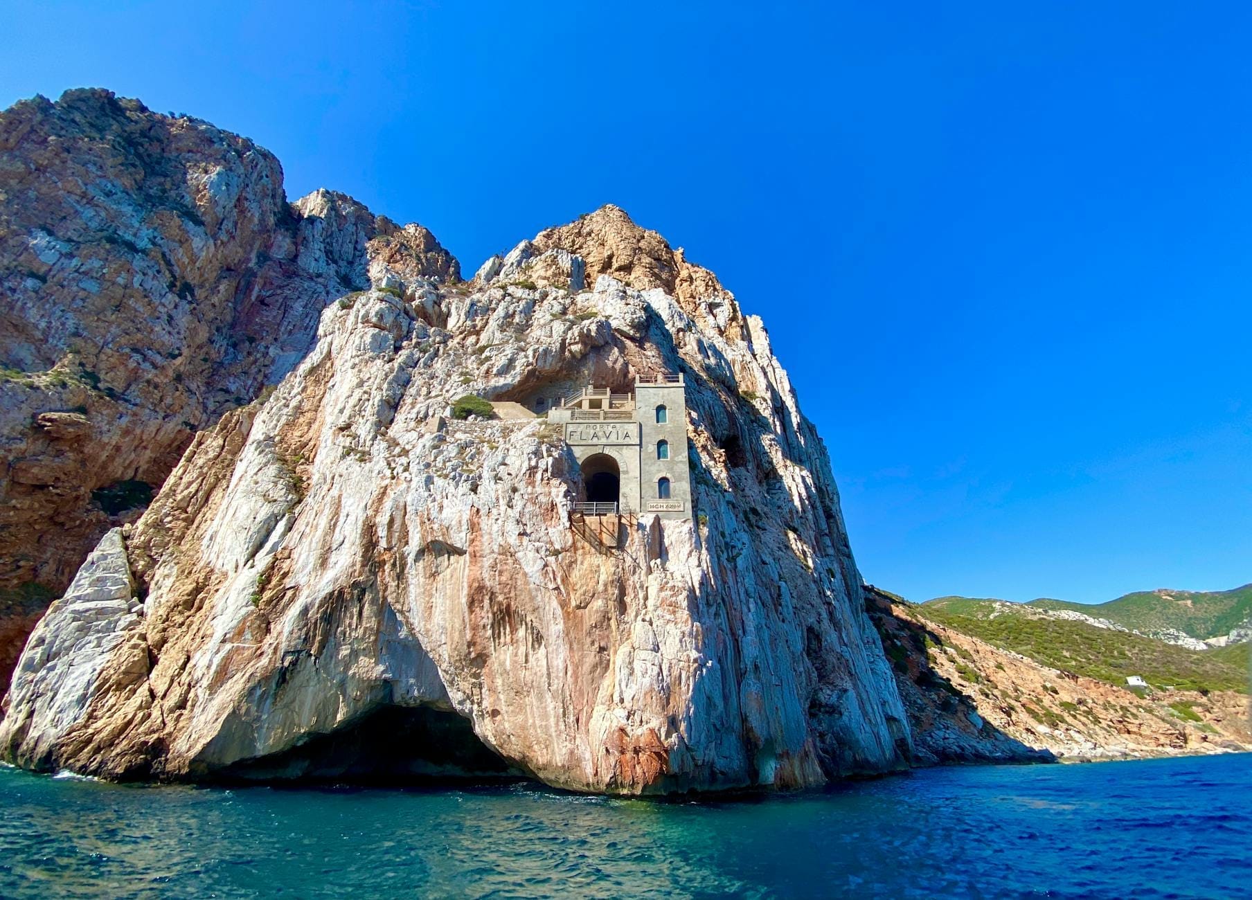
Porto Flavia is not a port in the traditional sense. There is no harbor, no quay, and nowhere for a boat to dock. Instead, it is a system of two superimposed tunnels drilled horizontally into a sheer limestone cliff face above the Mediterranean, with an opening on the seaward side from which ore was loaded directly onto anchored cargo ships waiting below. It was, in effect, a gravity-fed industrial conveyor built into the living rock of a coastal cliff.
Designed by engineer Cesare Vecelli and completed around 1923–1924, the structure served the lead and zinc mines of the surrounding Iglesiente area, a mineral-rich zone that had been mined since at least Roman times. The system allowed ore to be transported from inland mines via a network of rail trolleys, stockpiled in the upper tunnel, and then released through a chute into ships anchored some 50 meters below. It was an elegant solution to a very specific problem: how to export heavy ore from a coastline with no natural harbour.
The complex remained in operation until the 1960s, when the regional mining industry began its long decline. It was named after Flavia, the daughter of engineer Vezio Vecelli, who managed the project on behalf of the mining company. The name has stuck, and the structure is now one of the most photographed industrial heritage sites in Sardinia.
ℹ️ Good to know
All visits are by guided tour only. Tours in English are typically scheduled at 11:00, 12:00, 14:00, 16:00, and 18:00, but hours vary by season. Check the official Iglesias Turismo website and book ahead in July and August, when spots fill quickly.
The Guided Tour: What to Expect Inside
The tour begins at a small ticket office set into the hillside, roughly 200 meters from the parking area. From there, a path leads down to the entrance of the upper tunnel, and the temperature drops noticeably the moment you step inside. Even in the height of summer, when the coastal air outside can reach 35°C, the interior of the cliff stays cool and slightly damp. Bring a light layer regardless of what the weather says when you arrive.
The upper tunnel stretches approximately 600 meters through the rock on a fairly level dirt floor. Your guide will walk you through the mechanics of the loading system, pointing out the original rail tracks set into the ground, the remnants of ore storage bays, and the structural reinforcements added at different points during the site's operational life. The air smells of mineral dust and old stone, and the lighting is deliberately atmospheric rather than overly bright.
At the far end of the upper tunnel, you reach the seaward opening, a roughly rectangular aperture cut into the cliff face. The view from here is one of the more arresting in southwest Sardinia: the stack of Pan di Zucchero, a sea stack rising 133 meters from the water, sits directly in the frame, with the beach at Masua visible below. Photographers should note that midday light here tends to be harsh and flat. The late afternoon tours (16:00 or 18:00) catch warmer directional light on both the cliff face and the sea stack.
The lower gallery is accessed via a staircase of 108 steps. This section is narrower and feels more intimate. Here the guide explains how ore was transferred between levels and loaded onto ships through the lower aperture. Visitors with significant mobility limitations should be aware that the staircase is steep and uneven in places; there is no lift or alternative route.
💡 Local tip
Wear closed-toe shoes with grip. The tunnel floors are uneven dirt and rock, and some sections are slick with moisture. Sandals and flip-flops are impractical here, not just a precaution.
Tickets & tours
Hand-picked options from our booking partner. Prices are indicative; availability and final rates are confirmed when you complete your booking.
Balai Bay snorkeling experience from Porto Torres
From 42 €Instant confirmationFree cancellationAsinara island e-bike rental from Porto Torres
From 48 €Instant confirmationFree cancellationBoat Tour of Porto Cervo's beaches from Porto Rotondo
From 84 €Instant confirmationFree cancellationBoat excursion and snorkeling in Porto Conte marine area in Alghero
From 90 €Instant confirmationFree cancellation
The Landscape Around It: Masua and Pan di Zucchero
Porto Flavia sits within one of the most geologically distinctive stretches of Sardinian coastline. The cliffs here are pale grey limestone streaked with mineral oxides, dropping vertically to a sea that shifts between deep turquoise and near-black depending on depth and cloud cover. The Pan di Zucchero sea stack visible from the tunnel opening is the largest sea stack in Italy and one of the defining landmarks of the southwest coast. Its scale only becomes apparent once you realize the fishing boats that occasionally pass near its base are full-sized vessels.
The beach at Masua below is a small crescent of grey-white pebbles and coarse sand, reachable via a separate road and popular with locals in summer. It is not a polished resort beach. The water is clear and the setting is dramatic, but there are minimal facilities. Combining a Porto Flavia tour with a few hours at Masua beach makes for a logical and rewarding day. For those interested in exploring more of the coast, the Masua beach is only a short drive below the site.
The broader Sulcis-Iglesiente area is one of the least-visited parts of Sardinia, and deliberately so. It lacks the polished tourist infrastructure of the Costa Smeralda or even the more developed south coast near Cagliari. Roads here are narrow, signage can be sparse, and some of the best viewpoints require short hikes on unmarked paths. But for travelers willing to navigate on their own terms, this coastline rewards patience. The Sulcis and southwest coast is one of Sardinia's most underexplored corners.
Historical and Industrial Context
The Iglesiente mining district has one of the longest continuous histories of mineral extraction in the western Mediterranean. Lead, zinc, and silver were mined here by the Phoenicians, then the Romans, and again intensively from the 19th century onward under various Italian and foreign concessions. The town of Iglesias, roughly 20 kilometers inland, still bears the physical and cultural imprint of this history in its architecture and street plan.
Porto Flavia was built precisely because the surrounding coastline offered no viable natural harbour for heavy freight. The solution Vecelli engineered essentially turned the cliff itself into the loading infrastructure. It was completed in a period when the Sardinian mining industry was at one of its peaks of activity, and it remained the principal ore-export point for the region for four decades. For context on the broader network of mining-era structures and heritage sites across Sardinia, the Museo Arte Mineraria in Iglesias is the natural companion visit, covering the full history of regional mining from Roman tools to 20th-century equipment.
What makes Porto Flavia distinctive among industrial heritage sites is that the structure itself is largely intact. The rail tracks remain. The original loading mechanisms are partially in place. The cliff opening, through which thousands of tons of ore once passed, now frames a view of the same sea that cargo ships once navigated to collect their loads. The site does not require imagination to reconstruct. It is legible and physical in a way that many industrial ruins are not.
Practical Planning: When to Go and How Long to Stay
June through September is high season along this coast. Tour slots at Porto Flavia fill faster than most visitors expect, particularly at weekends in July and August. If you are visiting in peak summer, book online through the Iglesias Turismo website a day or two in advance. Showing up without a reservation on a busy Saturday afternoon is a gamble that regularly does not pay off.
May and September are arguably the best months to visit the southwest coast. Temperatures are warm but not punishing, the sea is swimmable, and the tourist pressure on the narrow coastal roads is significantly lower. October remains pleasant for sightseeing, though some tour times may be reduced as the season winds down. The shoulder months also mean you can combine Porto Flavia with a drive along the coast without spending half the day in traffic.
From Cagliari, Porto Flavia is roughly 90 kilometers by road via the SS130 and SS126, a drive of about 90 minutes. There is no express route. The roads are good but winding in the final stretch toward Masua. Public transport is possible but slow: train to Iglesias, then bus 808 to Masua. This option works if you have time and flexibility, but it limits you to specific departure times. For most visitors, a hire car is the practical choice for this part of the island. See getting around Sardinia by car for detailed guidance on driving in the region.
⚠️ What to skip
The final stretch of road to the Porto Flavia parking area is narrow and in places unpaved or rough. Standard passenger cars manage it without difficulty, but it is not suitable for low-clearance vehicles or large campervans. Do not attempt it after heavy rain without checking conditions first.
Who This Is For
Porto Flavia is not universally impressive in the way that a great beach or a famous cathedral is. The tour takes you through dark tunnels with a lot of technical explanation, and the primary reward is a view through a cliff window and the satisfaction of understanding how something quite clever was built a century ago. If that sounds like it might not hold your attention, it probably will not.
Children below the age of around eight or nine often struggle with the tour length and the density of historical information, and the 108-step staircase to the lower gallery eliminates the site for anyone with significant mobility challenges. Visitors expecting a beach excursion who have added Porto Flavia as an afterthought sometimes find it underwhelming.
For travelers with a genuine interest in industrial archaeology, engineering history, or the social history of Mediterranean mining communities, it is one of the most satisfying sites in southwest Sardinia. The combination of intact machinery, coastal drama, and a story that connects 20th-century industrial capitalism to a landscape that has been economically exploited for more than two millennia gives it a weight that purely scenic attractions lack.
Insider Tips
- Book the 16:00 or 18:00 English tour in summer. The late afternoon light turns the limestone cliffs gold and gives dramatically better photographs of Pan di Zucchero from the tunnel opening than the midday flat light allows.
- The upper tunnel temperature hovers around 14–16°C year-round. Even if you are visiting in August heat, pack a thin layer in your bag. You will want it after about ten minutes inside.
- After the tour, follow the small path that continues past the ticket office along the clifftop for roughly 100 meters. It leads to an unguarded viewpoint above the sea that most visitors miss entirely, giving a full elevated view of the tunnel opening and the sea stack together.
- If you are combining Porto Flavia with Masua beach on the same day, do the tour first. The beach road branches off before the Porto Flavia parking area, and it is psychologically difficult to leave the water and get back in a car to do a history tour.
- The Museo Arte Mineraria in Iglesias pairs naturally with Porto Flavia and takes about an hour. Together they give a complete picture of the regional mining industry from Roman extraction methods through to the industrial 20th century.
Who Is Porto Flavia For?
- Industrial archaeology and engineering history enthusiasts who want more than a scenic overlook
- Photographers looking for an unusual coastal composition combining architecture, geology, and sea
- Travelers on a southwest Sardinia road trip combining coastal scenery with cultural depth
- Couples looking for an off-the-beaten-path half-day experience away from crowded beaches
- Adults and older teenagers with an interest in social or economic history of the Mediterranean
Nearby Attractions
Other things to see while in Sulcis & the Southwest Coast:
- Carloforte (Isola di San Pietro)
Carloforte is the sole inhabited centre on Isola di San Pietro, a small island off Sardinia's southwestern coast with a strikingly un-Sardinian character. Founded in 1738 by Ligurian settlers from Tabarka, it retains its own dialect, cuisine, and urban architecture — a place that rewards slow exploration rather than quick sightseeing.
- Costa Verde
Costa Verde is a 47-kilometre arc of coastline in the Comune di Arbus, in Sardinia's southwest, running from Capo Frasca to Capo Pecora. It holds some of the most remote beaches on the island, including Piscinas, where dunes reach up to 60 metres high, making it one of the largest dune systems in Europe. There are no entry fees, minimal resort infrastructure directly on the beaches, and no public transport. That combination is exactly why it rewards visitors who make the effort to get here.
- Is Zuddas Caves (Santadi)
Carved into 530-million-year-old Cambrian dolomite beneath Monte Meana, the Is Zuddas Caves near Santadi are among the most geologically significant showcaves in Sardinia. Guided tours of a flat 500-metre route reveal towering stalactites, aragonite helictites, and chambers that once served as an alabaster quarry before local speleologists rescued them for science and tourism in 1971.
- Isola di Sant'Antioco
Sant'Antioco Island sits off Sardinia's southwest coast, connected to the mainland by a bridge over an ancient isthmus. With roots stretching back to Phoenician colonizers in the 8th century BC, it pairs serious archaeology with quiet beaches, a still-functioning fishing port, and some of the least-crowded coastline in the region.