Paseo de la Reforma: Mexico City's Most Iconic Boulevard
Paseo de la Reforma is an approximately 15-kilometer boulevard that cuts through the heart of Mexico City, connecting the historic center to Chapultepec Park past monuments, skyscrapers, and some of the city's best museums. Free to walk, endlessly layered, and unmissable on any visit.
Quick Facts
- Location
- Runs from Centro Histórico to Bosque de Chapultepec and beyond, Mexico City (CDMX)
- Getting There
- Metro: Juárez or Revolución (7–8 min walk); Metrobús Line 7 runs directly along the avenue
- Time Needed
- 1 hour for a focused stroll of the central 3 km; half a day if you visit museums along the way
- Cost
- Free to walk. Individual museums and attractions have separate admission fees (paid in MXN)
- Best for
- First-time visitors, architecture lovers, photographers, Sunday cyclists
What Paseo de la Reforma Is
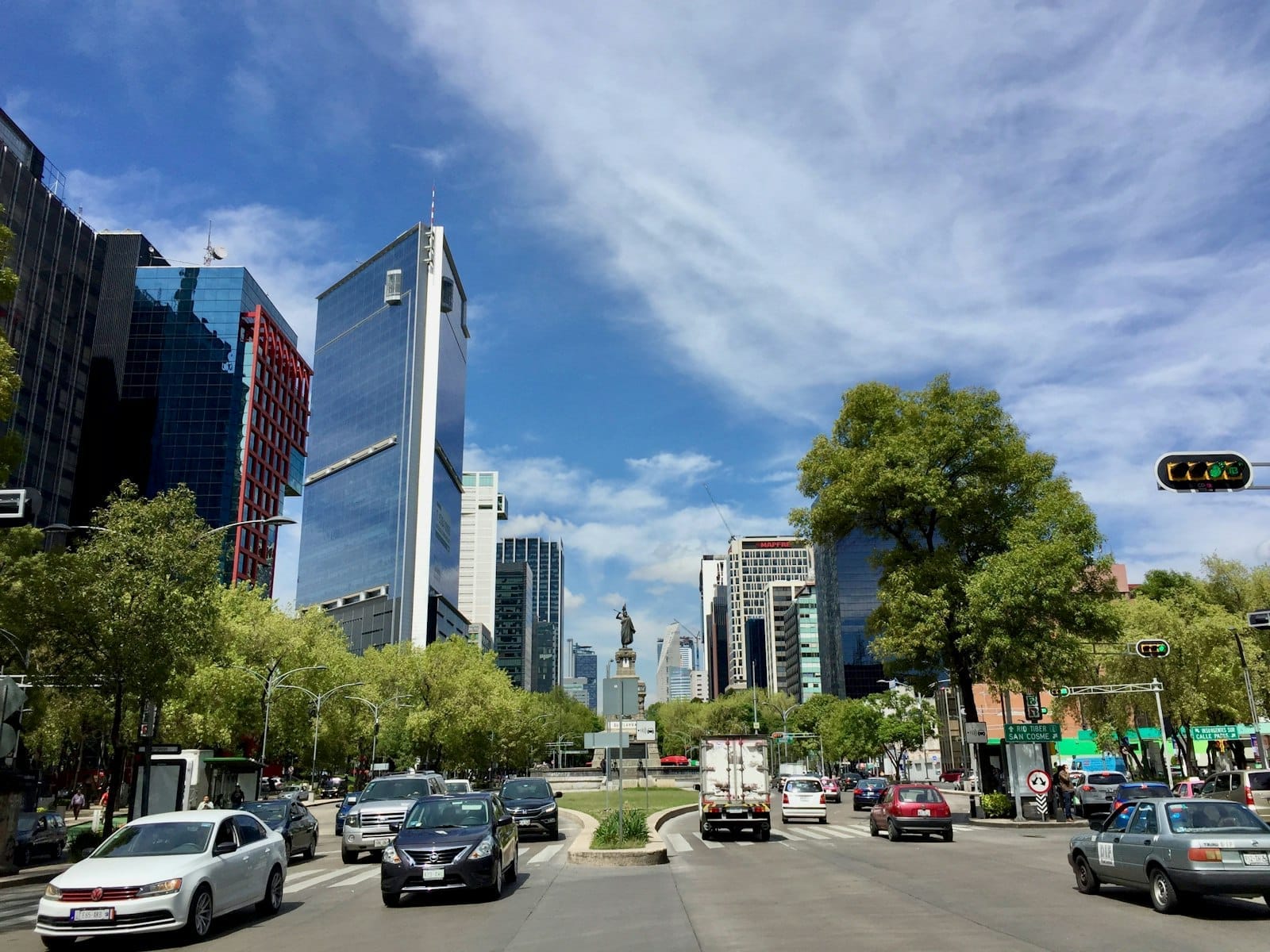
Paseo de la Reforma is Mexico City's most recognizable street, a wide diagonal boulevard that stretches approximately 15 kilometers across the city. Its central stretch, the roughly 3 kilometers between the historic center and the entrance to Chapultepec Park, is where most visitors spend their time. This section passes the Ángel de la Independencia monument, lines of high-rise offices and five-star hotels, and deposits you at the gates of one of the largest urban parks in the world.
The avenue is not a single contained attraction you visit and leave. It is the connective tissue between some of the city's most important landmarks. Walking it gives you a sense of how Mexico City stacks its layers: colonial-era statues in traffic roundabouts, 1960s office towers behind Art Nouveau facades, and modern glass skyscrapers reflecting the Ángel above.
💡 Local tip
Every Sunday from 08:00 to 14:00, motor traffic is excluded from the central section under the city's Muévete en bici program. The lanes fill with cyclists, joggers, and families. This is the best way to experience the boulevard's full scale without exhaust and noise.
A Boulevard Born from Imperial Ambition
Construction of Paseo de la Reforma began in 1864, ordered by Emperor Maximilian I of the short-lived Second Mexican Empire. The idea was functional as much as ceremonial: the emperor wanted a direct route between Chapultepec Castle, his official residence, and the National Palace in the historic center. The boulevard was modeled loosely on the Champs-Élysées in Paris, with broad lanes, tree-lined median strips, and a series of circular glorietas (traffic roundabouts) designed to anchor major monuments.
It was originally called Paseo de la Emperatriz, the Promenade of the Empress, in honor of Empress Carlota. After Maximilian was captured and executed in 1867, President Benito Juárez renamed it Paseo de la Reforma to commemorate the liberal Reform movement. The name stuck, and in a way the avenue's entire subsequent history is a story of that tension: grand European gestures continually being reclaimed and reinterpreted by Mexican political and cultural identity.
The avenue's glorietas were filled over the following decades with monuments to pre-Hispanic and national heroes. The most famous is the Ángel de la Independencia (officially the Columna de la Independencia), a gilded winged figure atop a roughly 36-meter column, completed in 1910 to mark the centennial of Mexican independence. If you want to understand its significance, the Monumento a la Independencia deserves its own visit. But seeing it from the boulevard at street level, rising above the traffic, is a formative Mexico City moment.
Tickets & tours
Hand-picked options from our booking partner. Prices are indicative; availability and final rates are confirmed when you complete your booking.
Puebla and Cholula guided tour from Mexico City with optional lunch
From 43 €Instant confirmationFree cancellationXochimilco, Coyoacan and Frida Kahlo Museum with skip-the-line tickets
From 63 €Instant confirmationFree cancellationMexico City exploration game and tour in Chimalistac
From 10 €Instant confirmationFree cancellationCuernavaca and Taxco Guided Tour with Optional Lunch
From 40 €Instant confirmationFree cancellation
Walking the Central Stretch: What You Actually See
Starting from the historic center end and walking west toward Chapultepec is the most logical direction. The eastern section of the avenue is calmer and less photogenic, transitioning through government office corridors. Things sharpen visually as you approach the Diana Cazadora fountain roundabout, a 1942 bronze sculpture of the hunting goddess that was originally nude and caused considerable public controversy before being clothed, then unclothed again after restoration.
The stretch between Diana Cazadora and the Ángel is the most intensely photographed part of the avenue. The sidewalks here are wide enough to move comfortably even on weekday afternoons, though the adjacent streets see heavy vehicle traffic. The smell of street food from nearby stalls drifts across the median in the late morning: corn, grilled meat, fresh-cut fruit. International bank headquarters and luxury hotels line both sides, several occupying early 20th-century buildings with ornate stone facades now sandwiched between towers of glass and steel.
Continuing west past the Ángel, the boulevard enters the Polanco-adjacent stretch, where the architecture shifts toward mid-century modernism. The Torre Mayor and Torre BBVA (among Mexico City's taller skyscrapers) become prominent here, rising above tree canopies that line the median. The air feels slightly cooler as Chapultepec's forest draws closer. Reforma ends, for practical walking purposes, at the main entrance to Chapultepec Park.
Time of Day: How the Boulevard Changes Hour by Hour
Early weekday mornings, from around 07:00 to 09:00, belong to commuters and joggers. The avenue moves fast. Coffee vendors work the Metrobús stops. The light at this hour, especially in the dry season months of February through April, falls low and clear across the median, catching the white marble of the Ángel column before the haze of the day builds up. Photographers willing to be out early will find the most undistracted compositions.
Midday on weekdays is the least pleasant time to walk the full length: foot traffic is heavy, the sun is direct (the city sits at about 2,240 meters above sea level, which means UV exposure is significantly stronger than at sea level), and vehicle noise is at its peak. If your schedule only allows a midday visit, confine yourself to the glorieta sections and take the Metrobús rather than walking the full stretch.
Late afternoons bring a different energy. Around 17:00 to 19:00, office workers spill onto the sidewalks, street food options multiply, and the sky shifts to the rose and amber tones that Mexico City is known for during clear dry-season evenings. The Ángel glows differently in this light than at noon, more gold, less bleached. Weekend evenings, particularly Saturday, see informal gatherings in the glorietas and amplified music from restaurant terraces along the side streets.
⚠️ What to skip
During the rainy season (May through October), afternoon thunderstorms can arrive quickly and drench the avenue with little warning. Pack a light rain layer if you are walking the boulevard in these months, especially between 14:00 and 18:00 when storms are most common.
The Museums Along the Route
One of Reforma's underappreciated qualities is its role as a cultural corridor. Within a few minutes' walk of the avenue, you can reach several major institutions. Near the Chapultepec end, the Museo Soumaya and Museo Jumex are free to enter (Soumaya year-round; Jumex general admission is free — verify on fundacionjumex.org) and stand in direct visual dialogue with each other in the Plaza Carso development just north of Reforma near the Polanco section.
Further along, the route to Chapultepec Park puts you within reach of the Museo Nacional de Antropología, widely regarded as the finest anthropological museum in the Americas. It sits inside the park itself, a 15-minute walk from where Reforma meets the park entrance. Budget at least two hours for it if you go.
The avenue itself also hosts rotating outdoor sculpture exhibitions in its median strips. These change periodically and have featured indigenous and contemporary Mexican sculptors. They are easy to miss if you are focused on traffic, but worth a slow look as you walk the central sections.
Practical Details for Getting There and Moving Around
Metrobús Line 7 is the most direct public transport option, running along the avenue itself between Campo Marte and Indios Verdes (with some sections using nearby streets). It connects with other Metrobús lines and the Metro at several points. If you are arriving from the Centro Histórico, the closest Metro stations are Juárez (Line 3) and Revolución (Line 2), each about a 7 to 8 minute walk to the main boulevard section.
Ride-hailing apps (Uber, DiDi, Cabify) work reliably along Reforma, though traffic can be heavy enough during peak hours that walking or taking the Metrobús is faster for short distances on the central stretch. Taxis hailed from the street are not recommended in Mexico City; use apps or authorized taxi stands instead.
Footwear matters on Reforma. The sidewalks are generally well-maintained on the central tourist section, but can be uneven near construction sites or older building frontages. Comfortable walking shoes with closed toes will serve you better than sandals if you plan to cover the full 3-kilometer central length. There is no shade for significant stretches, so sun protection is important year-round given the altitude.
ℹ️ Good to know
Paseo de la Reforma is free to walk at any hour. The Sunday car-free window (08:00–14:00) is run under the city's Muévete en bici program. No registration or permit is needed to participate as a pedestrian or cyclist.
Who Should Adjust Their Expectations
If you are visiting Mexico City primarily for colonial history or pre-Hispanic archaeology, Reforma is context, not destination. It is a modern avenue layered over 19th-century urban planning, and its historical depth pales next to the Zócalo or Templo Mayor area. Walk through it, by all means, but do not prioritize it over the core of the historic center.
Travelers looking for local neighborhood character should also temper expectations. The central Reforma corridor is heavily commercial, dominated by corporate offices and international hotel chains. For the kind of street life and architectural texture that defines Mexico City at its most interesting, the side streets of Roma, Condesa, and Coyoacán deliver more. The guide to Roma and Condesa is a useful companion read before deciding where to spend your afternoon.
Insider Tips
- The Sunday Muévete en bici closure typically runs 08:00–14:00, but the best hour is 08:00–09:30 before crowds peak. Bike rentals are available from informal stands along the route, or bring your own if staying nearby.
- For the best photograph of the Ángel de la Independencia with the city skyline behind it, position yourself on the western side of the glorieta looking east in the late afternoon. The column catches the light differently than it does at midday.
- The median strip sculptures change seasonally. Checking what is currently installed takes 30 seconds on the city's tourism site and can add a unexpected cultural element to a walk you might otherwise rush through.
- The Metrobús Line 7 stop names correspond directly to the major landmarks. Use Ángel de la Independencia as your stop name when navigating rather than a street address; it appears on maps and is widely understood.
- Several of the high-rise hotels along Reforma have rooftop bars open to non-guests. A drink with a view of the boulevard from above, looking toward either the historic center or Chapultepec, reframes the scale of the avenue in a way that ground-level walking cannot.
Who Is Paseo de la Reforma For?
- First-time visitors who want to understand Mexico City's scale and spatial logic
- Photographers working in the early morning or late afternoon light
- Cyclists and joggers on Sunday mornings when the lanes are car-free
- Travelers using the boulevard as a connective route between Chapultepec and the historic center
- Anyone interested in 19th and 20th-century urban planning and how political history reshapes public space
Nearby Attractions
Combine your visit with:
- Acuario Inbursa
Built beneath Plaza Carso in the Nuevo Polanco district, Acuario Inbursa holds 1.6 million litres of seawater and roughly 14,000 specimens across more than 230 species. It opened in 2014 and remains one of the most technically ambitious aquariums in Latin America. Here is what the visit actually involves, and whether it is worth your time.
- Arena México
Inaugurated in 1956 and holding up to roughly 16,800 spectators, Arena México is the home of CMLL and the most storied lucha libre venue in the world. Matches run on Tuesday, Friday, and Sunday evenings in Colonia Doctores, making it one of the most accessible live spectacles in Mexico City.
- Basilica of Our Lady of Guadalupe
The Basilica of Our Lady of Guadalupe is one of the most visited Catholic shrines on earth, receiving over 20 million pilgrims and visitors each year. Built around the 1531 apparition site on Tepeyac Hill, it holds the venerated tilma of Juan Diego and offers a rare encounter with living Mexican faith at its most intense.
- Cineteca Nacional
The Cineteca Nacional de México is the country's national film archive and its most important arthouse cinema complex. Rebuilt after a devastating 1982 fire and transformed in 2012 into a world-class cultural campus, it combines 10 indoor screens, a large open-air screening forum, galleries, a bookshop, and restaurants in a single destination that attracts cinephiles, students, and casual visitors alike.