Los Azulejos de Veneguera: Gran Canaria's Astonishing Rainbow Rocks
Along a remote stretch of the GC-200 coast road in Mogán, volcanic cliffs erupt into bands of green, ochre, red, and violet — the result of ancient hydrothermal processes. Los Azulejos de Veneguera is free, open-access, and one of the most visually striking geological sites in the Canary Islands.
Quick Facts
- Location
- GC-200 road, Mogán municipality — between Mogán and La Aldea de San Nicolás, Gran Canaria
- Getting There
- By car via GC-200 (roadside parking available); Global bus lines 38 and 86 from Puerto de Mogán pass the area — verify timetables before travel
- Time Needed
- 30 minutes to view from roadside; 2–3 hours for the full ~4 km walking route
- Cost
- Free — no admission fee, no ticket required
- Best for
- Geology enthusiasts, photographers, road-trippers, hikers, nature lovers
What Are Los Azulejos de Veneguera?
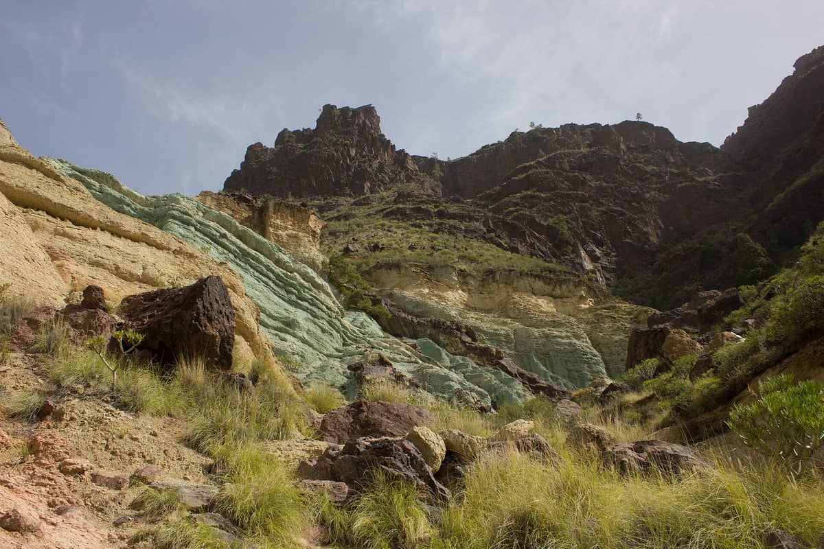
Los Azulejos de Veneguera — sometimes called The Rainbow Rocks in English-language sources — is a geological formation of extraordinary color along the GC-200 coastal road in the Mogán municipality of Gran Canaria. The name translates loosely as 'the tiles of Veneguera,' a reference to the way ancient volcanic rock has been fractured and stained into patterns that, from a distance, resemble decorative tilework.
The colors are not painted, not an optical illusion, and not the result of any recent intervention. They are the product of hydrothermal alteration: over millions of years, superheated water and volcanic gases moved through the rock, depositing iron oxides, chlorite, and other minerals that produce vivid bands of red, rust, ochre, deep green, violet, and cream. The effect is startling in a landscape that is otherwise dominated by dry, brown hillsides.
The site sits on the edge of the Inagua Nature Park, one of Gran Canaria's most remote protected zones. There are no entry gates, no visitor centers, and no facilities. What there is, is one of the most photographically compelling natural roadside stops on the entire island.
The Drive Along the GC-200: Setting the Scene
To reach Los Azulejos, you follow the GC-200, a narrow, winding coastal road that hugs the southwestern edge of Gran Canaria. This is not a road for hurried driving. It climbs and dips through ravines (barrancos), offers occasional glimpses of the Atlantic far below, and passes through terrain that feels genuinely isolated compared to the resort-heavy south. The air is dry and smells faintly of dust and wild herbs when the windows are down.
For drivers coming from the south, Puerto de Mogán is the natural starting point. From there, the GC-200 heads north toward La Aldea de San Nicolás, and the colored cliffs appear after a stretch of dramatic, largely uninhabited coastline. You will likely spot the formation before you find the parking area — the bands of color are visible against the hillside from a reasonable distance on a clear day.
💡 Local tip
There are no road signs specifically marking Los Azulejos de Veneguera for tourists. Use offline GPS coordinates or download the location before leaving areas with mobile coverage, as signal can be unreliable along the GC-200.
Roadside parking is reported nearby, but the space is informal and limited. Arrive early in the day to secure a spot without difficulty, and never block the road — the GC-200 carries local traffic and occasional agricultural vehicles regardless of how quiet it feels.
What You Actually See — and How Light Changes Everything
Standing at road level, the colored cliffs rise above you in irregular bands. The greens (from chlorite-rich minerals) tend to dominate the lower sections, while the reds and ochres from iron oxidation streak across the middle and upper faces. On overcast days, the tones feel muted and almost watercolor-like. Under direct midday sun, the contrast sharpens dramatically — the reds turn almost brick-orange and the greens become intensely saturated.
Morning light from the east hits the hillsides at an angle that brings out texture and shadow across the mineral banding. Late afternoon, as the sun moves west over the Atlantic, the colors warm noticeably — photographers consistently report the hour before sunset as producing the richest results. Mid-morning, roughly 9am to 11am, balances good light with manageable temperatures for those who want to hike rather than just photograph from the road.
ℹ️ Good to know
There are no shade structures at the site. In summer months (June–September), temperatures on these exposed hillsides can be uncomfortable by midday. Bring water, sunscreen, and a hat regardless of season.
The scale of the formation is easy to underestimate in photographs. Walking up closer — even a few minutes from the road — reveals that individual color zones span several meters vertically, and the mineral variations shift as you move laterally along the base of the cliff. The rock itself has a rough, sometimes crumbly texture in places, and the ground near the base is littered with fragments that carry the same color banding as the cliff face above.
The Walking Route: Going Beyond the Roadside Stop
Los Azulejos can be experienced as a two-minute roadside stop or as the centerpiece of a proper hike. The walking route through the Veneguera valley and surrounding terrain is a substantial hike rather than a short stroll; dedicated routes here can run well over 10 kilometers and take most of a day depending on pace and how long you linger at the colored cliffs. The terrain is rugged and involves some uneven ground, so proper footwear — trail shoes or sturdy sneakers at minimum — is non-negotiable.
The surrounding area connects to the broader landscape of inland Mogán, a terrain of deep ravines, sparse vegetation, and volcanic geology that rewards those who take time to explore. Gran Canaria's southwestern interior has very few visitors compared to its beaches and resort towns, making this one of the quieter corners of the island. For a fuller picture of the island's dramatic hiking terrain, the hiking guide to Gran Canaria covers trails of varying difficulty across the island.
The path itself is not formally maintained or waymarked to the same standard as some of Gran Canaria's official trails. Check recent trail reports before departing, carry a downloaded map, and let someone know your itinerary if you plan to go beyond the immediate roadside area. There are no rescue services stationed nearby.
⚠️ What to skip
There are no restrooms, drinking water, food vendors, or first aid facilities at Los Azulejos de Veneguera. This is an open natural site with no infrastructure. Carry everything you need before leaving the nearest town.
Geology and Context: Why These Colors Exist
Gran Canaria is a volcanic island of oceanic origin, formed by a hotspot beneath the Atlantic plate. Its geological history spans roughly 14 million years, and successive phases of volcanic activity have left an island with extraordinary internal complexity — ignimbrites, calderas, basalt flows, and hydrothermal systems all compressed into an area of 1,560 km².
Los Azulejos de Veneguera represents a specific chapter in that story: a zone where post-volcanic hydrothermal activity altered the original rock chemistry. As hot, mineral-rich water percolated through fractures in the volcanic mass, it reacted with the surrounding material. Iron compounds oxidized to produce reds and yellows. Chlorite and epidote created greens. Other mineral exchanges added the more unusual violet and cream tones. The result is a cross-section of geological time rendered in color, readable in the cliff face by anyone willing to look closely.
This geological complexity is not unique to this single spot — Gran Canaria's interior has several areas where the volcanic past is dramatically visible — but Los Azulejos is the most visually concentrated and accessible example. Other geological landmarks worth pairing with this visit include the ancient volcanic caldera at Bandama Caldera and the iconic basalt formation of Roque Nublo in the island's central highlands.
Practical Details: Getting There, Timing, and What to Bring
A rental car is by far the most practical way to reach Los Azulejos de Veneguera. The GC-200 is accessible but narrow in sections, and the drive itself is part of the experience — particularly when combining this stop with other points along the southwestern coast. Parking near the formation is informal and limited, so earlier in the day is better, especially on weekends when more visitors make the trip.
For those without a car, Global bus lines 38 and 86 from Puerto de Mogán are reported to pass through the area. Verify current timetables directly with Global before travel, as services on this route are infrequent and schedules change. For context on getting around the island more broadly, see the guide to getting around Gran Canaria.
The best months to visit for hiking comfort are November through April, when temperatures on exposed hillsides are cooler and the light tends to be cleaner. Summer visits are not impossible, but heat on the unshaded slopes can make any walking beyond the roadside unpleasant by mid-morning. The site is open year-round, with no fixed hours — access during daylight is recommended for both safety and photographic reasons.
Los Azulejos pairs well with a wider road trip along the GC-200, which also passes Puerto de las Nieves to the north and the coastal scenery of the Mogán area to the south. It can realistically be combined with a visit to Mirador del Balcón, another striking natural viewpoint on the island's western edge, into a half-day or full-day driving route.
Photography Tips and Who This Attraction Is Not For
Wide-angle lenses capture the full extent of the banded cliff and its relationship to the surrounding terrain. A telephoto or a zoom lens lets you isolate individual color zones and mineral patterns for more abstract compositions. Polarizing filters reduce glare from the rock surface under direct sun and make the greens and reds appear more saturated. The best light windows are roughly 9–11am and the last 60–90 minutes before sunset.
This is not an attraction for visitors who need facilities, comfort infrastructure, or clear signage. It is a raw, open natural site with no services. Travelers expecting a developed viewpoint with railings and interpretation panels will be disappointed. Similarly, those with limited mobility may find even the short walk from the road to close viewing positions uneven and tiring — the terrain is natural and unimproved.
For independent travelers comfortable with self-navigation and open landscapes, Los Azulejos de Veneguera is one of the more rewarding stops in Gran Canaria's less-visited interior — genuinely unusual, free, and completely unhurried.
Insider Tips
- Download an offline GPS track or save the coordinates before leaving Puerto de Mogán. Mobile signal drops out in several sections of the GC-200, and there are no roadside signs pointing specifically to the colored rocks.
- The formation looks best when photographed from slightly below and at an angle, rather than straight-on from the road. Walk a short distance along the roadside in each direction to find the most revealing perspective.
- If you plan to walk the full ~4 km valley route, start no later than 9am in summer months. By 11am, the exposed terrain becomes significantly hotter and the light flattens for photography.
- Combine the stop with a drive to Mirador del Balcón further north on the GC-200 for a half-day western coast circuit that covers two of Gran Canaria's most dramatic natural viewpoints in a single trip.
- The colored rocks are not fenced or protected from immediate contact — but do not chip or remove samples. The site sits within or adjacent to the Inagua Nature Park, and this is a protected natural environment.
Who Is Los Azulejos de Veneguera For?
- Geology and volcanology enthusiasts who want to see hydrothermal alteration in a visually dramatic setting
- Photographers looking for unusual color, texture, and light conditions away from the island's tourist circuit
- Road-trippers exploring the GC-200 western coastal route between Mogán and La Aldea de San Nicolás
- Hikers who want a quieter, less-frequented trail in Gran Canaria's southwestern interior
- Budget travelers — the site is entirely free with no admission, booking, or guided tour required
Nearby Attractions
Combine your visit with:
- Arteara Necropolis
The Arteara Necropolis is the most extensive aboriginal cemetery on Gran Canaria, with 809 stone burial mounds spread across 13 hectares inside the dramatic Barranco de Fataga gorge. It offers a rare, unhurried encounter with the island's pre-Hispanic Canarii people, well away from the resort crowds of the south.
- Bandama Caldera & Crater Viewpoint
Rising 574 metres above sea level, the Pico de Bandama offers the most striking volcanic panorama on Gran Canaria. Below stretches the Caldera de Bandama, a crater around 200 metres deep and about 1,000 metres across, formed by one of the island's most recent volcanic episodes. It is free to visit, takes under an hour from Las Palmas, and rewards visitors with views that stretch from the island's green interior to the Atlantic coastline.
- Barranco de los Cernícalos
Barranco de los Cernícalos is a 7 km round-trip ravine hike in central-eastern Gran Canaria where a year-round stream cuts through laurel forest, fern-draped cliffs, and small waterfalls. It is free to enter, requires no booking, and remains genuinely quiet compared to the island's more promoted highland routes.
- Cactualdea Park
Cactualdea Park sits in the remote western municipality of La Aldea de San Nicolás, where an extraordinary collection of cacti and succulents grows against a backdrop of volcanic rock and Atlantic light. It rewards visitors who make the journey with something genuinely unusual: a curated desert landscape that feels nothing like the resort south of the island.