Ku-ring-gai Chase National Park: Sydney's Ancient Bushland on the Doorstep
Gazetted in 1894 and spanning 14,976 hectares of sandstone ridges, tidal inlets, and Aboriginal heritage sites, Ku-ring-gai Chase National Park sits less than an hour north of Sydney's CBD. It rewards visitors with genuine wilderness, one of the richest concentrations of Aboriginal engravings in the country, and lookouts over Pittwater and Broken Bay that rival anything the city's rooftop bars can offer.
Quick Facts
- Location
- Northern Sydney, NSW — multiple park entrances off Bobbin Head Road, Ku-ring-gai Chase Road, and McCarrs Creek Road
- Getting There
- Turramurra or Mount Kuring-gai station (Sydney Trains T1 line); limited bus services inside the park — a car is strongly recommended
- Time Needed
- Half day minimum; a full day to cover West Head, Bobbin Head, and a walking trail
- Cost
- A$12 per vehicle per day (confirm current fees); vehicles over 8 seats: A$4.40 per adult, A$2.20 per child. Basin landing fee: A$3 adult, A$2 child
- Best for
- Bushwalkers, history seekers, photographers, families with older children, kayakers
What Ku-ring-gai Chase Actually Is
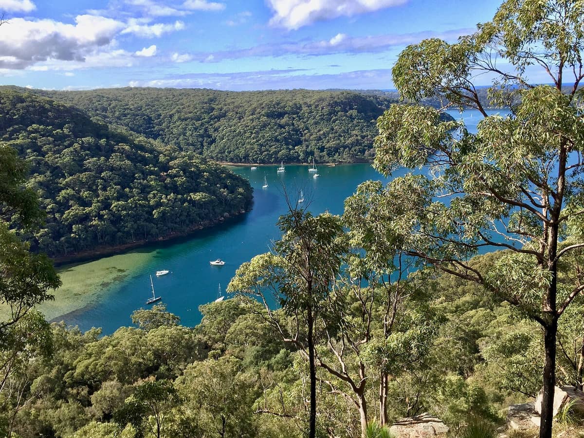
Ku-ring-gai Chase National Park is one of the oldest national parks in Australia, gazetted on 14 December 1894 with an original area of 13,500 hectares. It now covers 14,976 hectares of Sydney sandstone plateau, cut through by drowned river valleys that the sea reclaimed after the last ice age. The result is a landscape of sheltered inlets, mangrove-fringed waterways, exposed headlands, and heath-covered ridgelines that look out across Pittwater and Broken Bay to the Central Coast.
The park sits roughly 40 kilometres north of the Sydney CBD. That proximity is both its greatest selling point and its chief logistical challenge: it draws significant visitor numbers on weekends, particularly at Bobbin Head and West Head, but much of its trail network and waterway system remains genuinely quiet on weekdays. Unlike many urban-fringe parks, Ku-ring-gai Chase has not been manicured into a picnic-ground experience. Rock scrambles, unshaded ridgelines, and tidal crossings on some trails mean the park asks something of the people who visit it.
ℹ️ Good to know
Car access is almost essential. Public transport reaches the park's northern edges via Sydney Trains, but most key sites — West Head Lookout, Bobbin Head, and Aboriginal heritage tracks — require driving or a long additional walk from the station. Check Transport for NSW's trip planner before assuming bus connections.
Aboriginal Heritage: The Park's Most Significant Layer
Ku-ring-gai Chase holds one of the highest concentrations of Aboriginal rock engravings in the Sydney Basin. The Guringai people — whose Country covers this land — created engravings across sandstone platforms throughout the park, depicting fish, whales, human figures, shields, and ceremonial images. The figures were pecked and abraded into the rock surface, and many remain remarkably clear. The Basin Track, the Resolute Loop, and the area around West Head all pass near engraving sites.
The most accessible engraving site for most visitors is the Red Hands Cave track near Bobbin Head. The cave shelters ochre hand stencils — a different technique from the open-platform engravings — and the short walk to reach it passes through closed forest with a noticeably different feel from the exposed heath on the ridges. For broader context on Aboriginal culture and Country across Sydney, the Sydney Aboriginal culture guide covers the wider significance of Guringai and other First Nations connections to the region.
Approach these sites with care. The engravings are part of a living cultural heritage, not an outdoor museum exhibit. Stay on marked paths, do not touch, chalk, or wet the rock surfaces, and keep noise down around the sites. NSW National Parks asks visitors to treat the areas with the same respect they would give any place of cultural or spiritual significance.
Tickets & tours
Live prices and dates from our booking partner. If you book, we may earn a commission at no extra cost to you.
Vivid Sydney Festival bring-your-own-drink catamaran cruise
From 30 €Instant confirmationFree cancellation15,000 Ft Skydive in Wollongong During the Weekend
From 254 €Instant confirmation15,000Ft Wollongong Skydive During Weekend with Transfer from Sydney
From 254 €Instant confirmationThe Rocks historic walking tour
From 20 €Instant confirmationFree cancellation
West Head: The Park's Signature View
West Head is the promontory at the park's northern tip, and the view from West Head Lookout is one of the genuinely great Sydney views that most city visitors never see. Looking north across Broken Bay and the mouth of the Hawkesbury River, with Lion Island in the middle distance and the Central Coast ridgeline beyond, the scale of the landscape resets expectations quickly. On a clear morning, the light off the water is sharp and the air carries the specific salt-and-eucalyptus combination that is particular to sandstone headlands near the sea.
The lookout has a sealed, step-free path from the carpark to the viewing platform, with an accessible parking space available. This makes it one of the more inclusive viewpoints in the northern Sydney region. The West Head gates close at 8:30pm during daylight saving time and at 6pm otherwise, with a 6am opening, so plan your timing accordingly.
Arrive at West Head before 9am on weekends and you will often have the lookout to yourself for the first thirty minutes. By 10:30am on a sunny Saturday, the carpark fills and the trail to the Aboriginal engraving site nearby sees steady foot traffic. If you are combining West Head with the Barrenjoey Lighthouse at Palm Beach — visible from the lookout across Pittwater — allow at least half a day for both.
💡 Local tip
Photography tip: West Head Lookout faces roughly north, which means morning light falls across the water from the east and afternoon light warms the sandstone cliffs to the west. Both have strong qualities. Midday in summer produces flat, harsh light that bleaches the water — early or late is consistently better.
Bobbin Head and the Waterway Experience
Bobbin Head sits at the southern end of Cowan Creek inlet, and its atmosphere is entirely different from the exposed headlands elsewhere in the park. Here the water is calm and tannin-dark, flanked by mangroves and steeply wooded slopes. Cormorants dry their wings on the boat ramp pylons. Pelicans work the edges of the channel with a patience that borders on theatrical. The sound, particularly in the early morning, is dominated by water movement and birdsong rather than anything human-made.
A visitor centre is located at Bobbin Head — check current operating details before you go. The picnic facilities are well-maintained and genuinely shaded, which matters in summer when the sandstone ridges elsewhere in the park become radiantly hot. Kayaks and canoes can be hired from the Bobbin Head area; paddling up Cowan Creek is one of the more peaceful ways to spend a few hours in the park, with egrets and black swans appearing in the shallower reaches.
Walking Trails: What to Expect on the Ground
The park's trail network ranges from the flat and short to the genuinely demanding. A few useful benchmarks: the Sphinx Track from Bobbin Head down to the Hawkesbury River is a full-day return with significant elevation change and no reliable water along most of the route. The Resolute Loop at West Head is a moderate few-hour circuit that passes engraving sites and water views. The Basin Track connects West Head to The Basin campground, which is only accessible by foot or by ferry from Palm Beach — that ferry trip is worth knowing about if you want a coastal approach.
Trails are marked but not always obvious at junctions. Download the NSW National Parks app or carry a printed map from the visitor information pages before setting off. Mobile coverage is patchy or absent on most trails. In summer, heatstroke is a real risk on north-facing sandstone sections — the rock surface temperature climbs well above air temperature and there is often no shade for extended stretches. In wet weather, the same rock surfaces become slippery, and some creek crossings become impassable.
- Carry at least two litres of water per person regardless of trail length
- Wear closed shoes with grip — the sandstone surface ranges from smooth and flat to broken and steep
- Check fire danger ratings before visiting; the park can be partially or fully closed during extreme fire weather
- Download trail maps in advance; mobile coverage is unreliable inside the park
- Wildlife includes eastern brown snakes — watch where you step and sit, particularly on rocky outcrops
⚠️ What to skip
Ku-ring-gai Chase is genuine bushland, not a theme park. Mobile emergency services are limited inside the park. Tell someone your plans before heading out on any trail longer than two hours.
When to Visit and How the Experience Changes by Season
Spring (September to November) is the most recommended period by most regular visitors. Wildflowers appear across the heath — banksias, waratahs, and flannel flowers among them — and temperatures sit in the low-to-mid 20s Celsius, making longer walks comfortable. Rainfall remains possible across all months, but the spring months at Sydney Airport averages show lower monthly totals than the summer peak.
Summer brings heat, fire danger, and school holiday crowds to the popular sites. Bobbin Head fills early and the West Head carpark can reach capacity before midday on school-holiday weekdays. If you visit in summer, arrive before 8:30am and plan to be off exposed trails by 11am. Autumn (March to May) offers similar temperature comfort to spring and tends to see smaller crowds, though Easter long weekends are an exception. Winter is mild by Australian standards — daytime temperatures around 17 to 19 degrees Celsius — and the low winter sun makes for good photography. The park is noticeably quieter and wildlife, particularly waterbirds, can be easier to observe in the calmer conditions.
If you are planning a broader northern Sydney day with multiple stops, pairing Ku-ring-gai Chase with Palm Beach or a walk along the Manly Scenic Walkway makes geographic sense and keeps you in the same arc of the city.
Getting There and Practical Logistics
The park has several entrances and no single visitor centre serving all of them. The Bobbin Head Road entrance at North Turramurra is the most commonly used for the southern part of the park. The West Head area is accessed via Ku-ring-gai Chase Road off the Pacific Motorway, then McCarrs Creek Road — allow around 50 minutes driving from the Sydney CBD in light traffic, longer during school holiday periods.
The vehicle day-use fee of A$12 is payable at entry points. Park in designated carparks only — the sandstone roadside verges are fragile and vehicles parked on them cause lasting damage. If you are arriving by train to Turramurra or Mount Kuring-gai, check current Transport for NSW timetables for connecting bus services; the connections are infrequent and timing your return journey carefully matters.
For visitors combining the park with a ferry crossing from Palm Beach to The Basin campground, the Sydney ferry guide has broader context on the city's water transport network, though the Palm Beach ferry to The Basin is a private service operated separately from Transport for NSW.
Insider Tips
- The Basin campground is only reachable on foot or by ferry from Palm Beach — it books out weeks in advance on long weekends. If you want to stay overnight in the park, check the NSW National Parks booking system well ahead of your trip.
- Weekday visits between school terms offer a markedly different experience. The Bobbin Head picnic area, which feels crowded and social on a Saturday, is often nearly empty on a Tuesday morning, and wildlife is easier to spot in the quiet.
- The McCarrs Creek Road drive between the Pacific Motorway and West Head is itself worth slowing down for. Several informal pull-offs give views over Salt Pan Cove and into the upper reaches of Pittwater that most visitors miss by driving straight through.
- West Head is one of the better spots around Sydney to watch the seasonal migration of humpback whales, which typically pass through Broken Bay between May and November. Binoculars are useful.
- If you want to see the Red Hands Cave ochre stencils without the main Bobbin Head crowds, the trail to the cave starts from a separate carpark on Bobbin Head Road — most visitors at the main Bobbin Head picnic area do not realise the cave trail exists.
Who Is Ku-ring-gai Chase National Park For?
- Walkers and hikers wanting genuine bushland within an hour of central Sydney
- Anyone with a serious interest in Aboriginal rock art and Guringai heritage
- Nature photographers chasing sandstone heathland wildflowers, waterbirds, and wide harbour views
- Families with older children who are comfortable on uneven terrain and can manage a few hours without phone coverage
- Kayakers and paddlers looking for calm, sheltered tidal waterways
Nearby Attractions
Combine your visit with:
- Blue Mountains National Park
Blue Mountains National Park covers around 268,000 hectares of sandstone plateaus, deep gorges and temperate rainforest west of Sydney. It is a popular national park in New South Wales and one of the most rewarding day trips or overnight escapes from the city, provided you know where to go and when to arrive.
- Featherdale Wildlife Park
Featherdale Sydney Wildlife Park in Doonside is one of the few places near Sydney where you can get genuinely close to Australian wildlife, from koalas and wombats to Tasmanian devils and freshwater crocodiles. Open daily from 8:00 am, it suits families and animal lovers who want more than a glimpse through a fence.
- Figure Eight Pools
Figure Eight Pools are naturally formed rock pools on the coastal shelf of Royal National Park, south of Sydney. Reaching them requires a 6km return walk over steep terrain and careful timing around tides and surf. The reward is a striking geological curiosity in one of Australia's oldest national parks.
- Hunter Valley Wine Region
The Hunter Valley is Australia's oldest premium wine-producing region, sitting roughly two hours north of Sydney. Spread across 2,605 hectares of vineyard land near the village of Pokolbin, it rewards visitors with cellar door tastings, open countryside, and a pace that feels genuinely removed from city life. Whether you come for a single afternoon or a full weekend, understanding how the region works before you arrive makes a real difference.
Planning a trip? Discover personalized activities with the Nomado app.