Manly Scenic Walkway: The Spit Bridge to Manly Walk Worth Every Step
The Manly Scenic Walkway traces 10 kilometres of undeveloped Sydney Harbour foreshore between Spit Bridge and Manly Wharf. Free to walk, rich in Aboriginal heritage and colonial history, and genuinely quieter than its reputation suggests, this is one of Sydney's most rewarding half-day outings for anyone who can handle a moderate trail.
Quick Facts
- Location
- Manly Wharf to Spit Bridge, Northern Beaches, Sydney NSW
- Getting There
- Ferry to Manly Wharf (Circular Quay), then walk north; buses serve Spit Bridge near Mosman
- Time Needed
- 3–4 hours one-way (approx. 10 km); allow extra for detours and rest stops
- Cost
- Free (ferry fare applies separately; parking A$5–A$8/day at some park entry points)
- Best for
- Walkers, harbour views, nature lovers, half-day explorers from Sydney CBD
What the Manly Scenic Walkway Actually Is
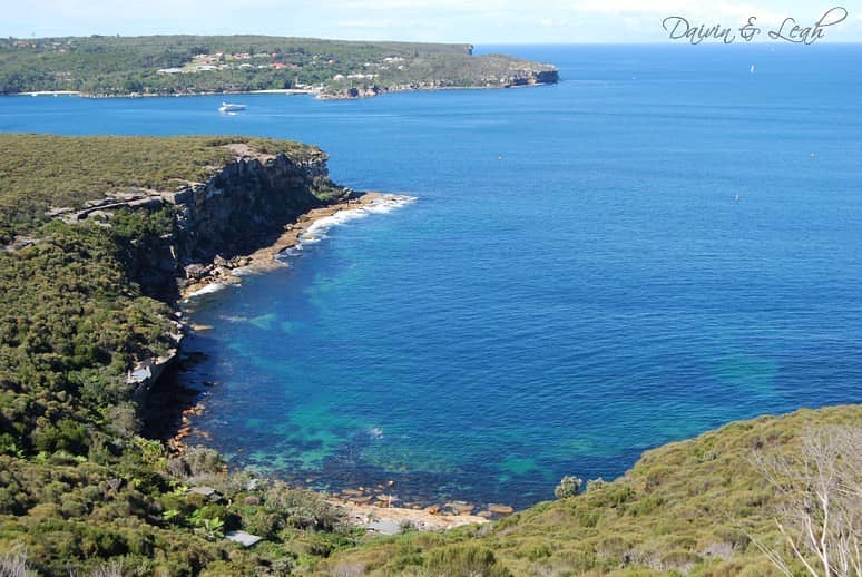
The Manly Scenic Walkway is a 10-kilometre one-way walking track through Sydney Harbour National Park, linking Spit Bridge in the north with Manly Wharf in the south.. The walkway follows the harbour foreshore through Sydney Harbour National Park and is managed by NSW National Parks.
The trail alternates between narrow bush paths, rocky headlands, small beaches, and brief residential street sections. It passes through several distinct parcels of Sydney Harbour National Park, including Dobroyd Head and Grotto Point, and skirts private foreshores where the park boundary runs close to backyards. This patchwork geography is what gives the walk its variety: you move between dense Sydney blue gum forest and open harbour outlooks within the space of a few hundred metres.
ℹ️ Good to know
The walk is one-way with no loop option. Most visitors start at Spit Bridge and finish at Manly Wharf, where ferries connect to Circular Quay. Plan your return transport before you start.
Getting There and Setting Off
The most satisfying approach is to take the Manly Ferry from Circular Quay. The 30-minute crossing across Sydney Harbour is itself a worthwhile experience, and it deposits you directly at Manly Wharf, The most satisfying approach is to take the Manly Ferry from Circular Quay. The 30-minute crossing across Sydney Harbour is itself a worthwhile experience, and it deposits you directly at Manly Wharf, the walk's southern endpoint.. Check the Sydney ferry guide for current timetables and Opal card fares. From the wharf, follow the foreshore path northwest past the small beach at Manly Cove, then pick up the signed trail markers heading into the national park. Signage is clear but not constant — carry a downloaded map or the NSW National Parks app.
Alternatively, start from Spit Bridge and walk south to Manly. Alternatively, start from Spit Bridge and walk to Manly. This direction means finishing at the ferry wharf rather than a bus stop, which simplifies the return journey considerably. Buses on the Spit Bridge side run toward Mosman and can be caught on Military Road. If you are driving, parking at the Spit Bridge end is possible on surrounding streets, though spaces fill early on weekends.
Wear proper walking shoes with some grip — sections around Grotto Point involve uneven sandstone rock platforms, and the trail surface after rain can be slippery with leaf litter. Carry at least 1.5 litres of water per person; there are no water fountains along the route. A hat and sunscreen matter, particularly on the open headland sections between mid-morning and mid-afternoon.
Tickets & tours
Live prices and dates from our booking partner. If you book, we may earn a commission at no extra cost to you.
Blue Mountain tour with Scenic World, Waterfalls and Zoo
From 158 €Instant confirmationFree cancellationBlue Mountains guided tour with Sydney Zoo and Scenic World visit
From 134 €Instant confirmationFree cancellationSydney Harbour scenic flight - private 20 minutes tour
From 404 €Instant confirmationFree cancellationSydney harbour 20 minutes scenic flight
From 147 €Instant confirmationFree cancellation
What You See Along the Route
The first hour out of Manly passes through Fairlight and Balgowlah Heights, with alternating bush and glimpses of the harbour through she-oaks and Sydney red gums. The canopy is dense enough to muffle traffic noise within minutes of leaving the wharf area. You will hear currawongs before you see them, and there is a reasonable chance of spotting rainbow lorikeets and eastern water dragons near the creek crossings.
The Grotto Point section, roughly the midpoint, is the walk's geological centrepiece. Flat sandstone rock platforms extend toward the water, and at low tide you can pick out Aboriginal engravings: a whale and a variety of marine figures etched into the stone surface. These engravings are believed to date back thousands of years and represent the Cammeraygal people, the Traditional Custodians of this harbour foreshore. They are fragile and unprotected, so the rule is simple: look without touching or stepping on the carved areas.
Beyond Grotto Point, Dobroyd Head opens up the best unobstructed harbour views of the walk. On a clear day you can see across to Sydney Harbour Bridge and the CBD skyline to the south. This is where most walkers stop to eat and take photographs. The light is at its best before 10 am and again in the late afternoon when the sun moves behind you and the water reflects cleanly. Midday in summer produces flat, washed-out conditions for photography and uncomfortable heat on the exposed rock.
Before the Spit Bridge end, the trail passes Clontarf Reserve, where the path widens and the surrounding vegetation shifts from dense bush to more manicured parkland. Clontarf Beach, a small sheltered harbour beach in this reserve, is a reasonable rest stop before the final approach to the bridge. On warm weekends, families gather here for picnics, and the contrast with the quiet upper sections of the walk is noticeable.
How the Walk Changes by Time of Day
Early mornings, particularly on weekdays, offer the walk at something close to its original solitude. By 7 am the light is low and golden across the harbour, most of the trail is in shade, and you may complete entire sections without passing another person. Wildlife is most active in this window: the probability of seeing a brush-tailed possum clinging to a branch or a sea eagle circling above the harbour is highest before 9 am.
Weekend mornings between 9 am and noon see the heaviest foot traffic, particularly near the Grotto Point rock platforms and Dobroyd Head lookout. The trail is wide enough that congestion is never a serious problem, but the sense of quiet disappears. If you prefer genuine solitude, a Tuesday or Wednesday start at 7:30 am produces a meaningfully different experience than a Saturday at 10 am.
💡 Local tip
Sydney Harbour National Park operates sunrise to sunset. Arrive at Manly Wharf by 8 am in summer and you will clear the best viewpoints before the bulk of weekend foot traffic arrives. Closures can occur during high fire danger periods in late summer — check the NSW National Parks website before setting out.
Difficulty, Fitness, and Practical Preparation
NSW National Parks classifies the Manly Scenic Walkway as a Grade 3 trail. That rating is appropriate. The terrain is not technically demanding, but 10 kilometres with repeated short climbs and descents over sandstone and root-covered ground asks more of the body than a casual stroll. Total elevation gain across the route is modest but cumulative: expect tired legs by the Clontarf end if you are not a regular walker. Allow 3 hours 30 minutes to 4 hours 30 minutes without rushing, or longer if you stop to read signs, photograph wildlife, and explore the Grotto Point platform.
The trail is not suitable for prams or wheelchairs given the uneven surface and several steeper rocky sections. The NSW Government notes that the attraction welcomes visitors with access needs and recommends contacting NSW National Parks for details about any accessible segments or alternative viewing areas nearby.
For those who want a shorter or easier coastal experience on the Northern Beaches, Shelly Beach is a 20-minute walk from Manly Wharf in the opposite direction and requires no trail navigation at all.
Historical and Cultural Context
The land the walkway passes through is part of the Country of the Cammeraygal (also rendered as Guringai or Kuring-gai) people, who occupied the northern shores of Sydney Harbour for tens of thousands of years. The engravings at Grotto Point are among the most accessible examples of rock art along this stretch of harbour, though they represent only a fraction of the ceremonial and everyday sites that once dotted the foreshore. Approaching the site with this context changes how the walk reads: the path is not simply passing through parkland but through a landscape still carrying layered human meaning.
The 1988 opening of the walk coincided with Australia's Bicentennial year, a period of both national celebration and significant debate about colonial history and Aboriginal rights. The walkway's formal establishment drew attention to the foreshore as a place of public heritage rather than private access. For broader context on Sydney's Aboriginal cultural landscape, the Sydney Aboriginal culture guide covers key sites and organisations across the city.
Who This Walk Is Not For
If the point of your day is a view from a comfortable spot, the Manly Scenic Walkway is not the right choice. The headline harbour panoramas are real, but you earn them over several kilometres of uneven ground. Travellers with knee or ankle problems should look carefully at the terrain before committing, particularly the Grotto Point descent.
The walk also disappoints in one specific scenario: humid Sydney summer afternoons. Between December and February, humidity can make the enclosed bush sections feel stifling by midday, and exposed rock platforms radiate stored heat in a way that is unpleasant without a strong breeze. If you are visiting in summer and want a coastal walk, the early-morning window is not optional, it is the product.
Visitors looking for a shorter but equally scenic coastal walk on the eastern side of Sydney might prefer the Bondi to Coogee coastal walk, which has more facilities, paved sections, and café stops along the way.
Insider Tips
- The Aboriginal rock engravings at Grotto Point are easier to see when the light is low and raking across the stone surface. Early morning or late afternoon visits make the carved lines far more visible than midday inspections.
- If you finish at Spit Bridge and need to catch a bus back to the city, the stop on Military Road serves routes toward Neutral Bay and Wynyard. Check the Transport for NSW trip planner before you leave the trail, as frequency drops on Sunday afternoons.
- A small tidal beach called Reef Beach sits roughly halfway along the route and is largely unknown to first-time walkers. It is clothing-optional by convention and offers a sheltered swim in calm harbour water — the kind of spot that does not appear on most tourist maps.
- Download the NSW National Parks trail map to your phone before starting. Mobile signal drops out in the deeper bush sections, and the trail junctions near Dobroyd Head can be confusing without a reference point.
- Combine the walk with the Manly Ferry crossing at dawn for an exceptionally different experience: the city skyline is at its most photogenic, the harbour surface is calm, and the wharf is quiet enough that you can hear the water.
Who Is Manly Scenic Walkway For?
- Walkers wanting a genuine half-day nature experience within easy reach of Sydney CBD
- History and culture seekers interested in Aboriginal heritage sites and colonial-era harbour geography
- Photographers chasing harbour light without the crowds of more publicised viewpoints
- Travellers who have already done the Bondi to Coogee walk and want the quieter, more rugged northern alternative
- Couples and small groups looking for a full morning away from the city without leaving Sydney
Nearby Attractions
Other things to see while in Manly & the Northern Beaches:
- Barrenjoey Lighthouse
Barrenjoey Lighthouse crowns the northern tip of Palm Beach on a sandstone headland above Pittwater and the Pacific Ocean. The 1881 sandstone tower rewards the 1km climb with some of the most far-reaching coastal views in greater Sydney, and a Sunday guided tour opens the historic interior for a deeper look.
- Manly Beach
Manly Beach stretches along Sydney's Northern Beaches, backed by Norfolk Island pines and connected to the city by one of the world's great ferry rides. Free to enter, patrolled year-round, and far more relaxed than Bondi, it rewards visitors who make the short trip north.
- North Head Sanctuary
North Head Sanctuary sits at the northern jaw of Sydney Harbour, where military history, ancient heathland, and sweeping ocean views converge on a single dramatic headland. Free to enter and refreshingly quiet by Sydney standards, it rewards those willing to make the short trip out from Manly.
- Palm Beach
Palm Beach sits at the northern tip of Sydney's coastline, where a long arc of sand separates the open Pacific from the sheltered waters of Pittwater. Add a working 1881 lighthouse on the headland above, and it's easy to understand why this stretch of NSW coast has become an enduring benchmark for what a Sydney beach can be.
Planning a trip? Discover personalized activities with the Nomado app.