Historic Railroad Trail: Hiking Through the Tunnels That Built Hoover Dam
The Historic Railroad Hiking Trail follows the original rail line that carried workers and materials to Hoover Dam in the 1930s. The 3.7-mile route passes through five hand-bored tunnels and offers sweeping views of Lake Mead — all within Lake Mead National Recreation Area, about 30 miles from Las Vegas.
Quick Facts
- Location
- Lake Mead National Recreation Area, near Boulder City, NV — approx. 30 miles southeast of Las Vegas
- Getting There
- Car only; trailhead parking below the Alan Bible Visitor Center on Lakeshore Road, or start from the Hoover Dam parking garage
- Time Needed
- 2–4 hours for the full out-and-back (7.5 miles); 1–2 hours for a shorter tunnel-only section
- Cost
- No trail fee; Lake Mead NRA entrance: $25/vehicle, $15/person on foot or bicycle (card payment required)
- Best for
- History lovers, casual hikers, families with older kids, photography, day-trippers from Las Vegas
- Official website
- www.nps.gov/thingstodo/hike-the-historic-railroad-trail.htm
What the Historic Railroad Trail Actually Is
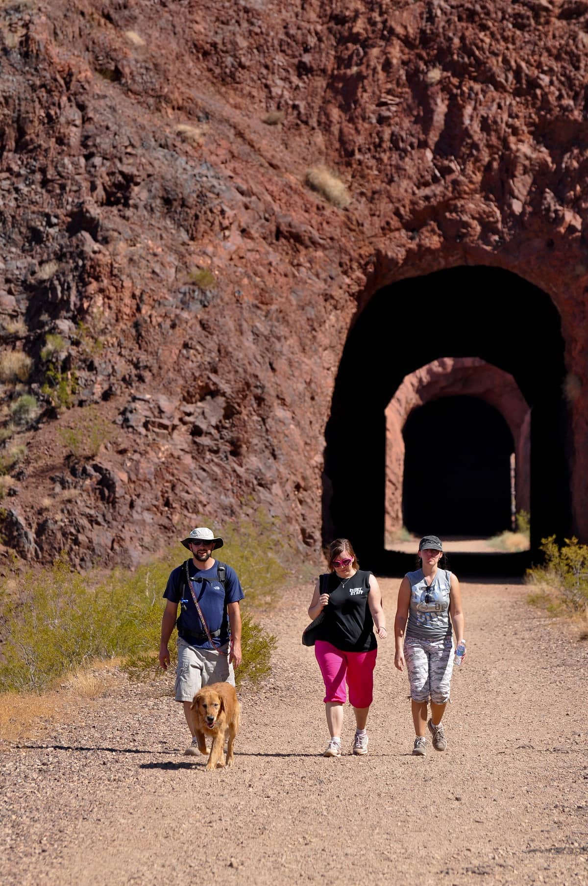
The Historic Railroad Hiking Trail is a 3.7-mile one-way route (7.5 miles round trip) that follows the original standard-gauge railroad alignment used during the construction of Hoover Dam in the 1930s. The railroad carried workers, concrete, and equipment through the volcanic hills above what is now Lake Mead. When the dam was complete and the railroad was no longer needed, the tracks were pulled up — but the grade, the cuts through the rock, and most remarkably, five tunnels bored directly through the basalt ridgeline, were left largely intact. Those tunnels are now what draw most hikers to the trail.
The route sits entirely within Lake Mead National Recreation Area and connects the Alan Bible Visitor Center near Boulder City to the Hoover Dam parking garage on the Nevada side. The trail was designated a National Recreation Trail in 1992, and the full connection to Hoover Dam was opened to hikers around 2007. It runs east-to-west across hillsides above the lake, and the views shift constantly as you move between exposed ridgeline and the cool darkness of the tunnels.
ℹ️ Good to know
The trail is open during daylight hours only. Lake Mead National Recreation Area itself is open year-round, 24 hours a day, but trail use is limited to dawn to dusk. The entrance fee applies to the park as a whole — not to the trail specifically. Cash is not accepted at fee stations; bring a card.
The Five Tunnels: What to Expect Inside
The tunnels are the defining feature of this hike, and they deliver something you will not find anywhere else near Las Vegas. Each one is large enough to walk through comfortably — wide, square-cut openings bored through dark volcanic basalt — and long enough that you briefly lose all ambient light in the center section. The longest tunnels run several hundred feet through solid rock. Inside, the temperature drops noticeably compared to the desert air outside, which matters enormously in summer.
The tunnel floors are uneven in places and the interior walls are rough-cut and damp in some sections, so bring a flashlight or use your phone torch. The contrast between the dark interior and the bright desert opening at each end makes for some of the best photography on the trail. Early morning light angling through a tunnel exit creates a near-perfect geometric frame over Lake Mead below. If you want that shot, start from the Alan Bible Visitor Center end so the eastern morning light is working in your favor.
💡 Local tip
A headlamp or flashlight is genuinely useful in the longer tunnels, not just optional. Phone screens provide enough light to walk safely, but a dedicated torch lets you read the rock faces and original drill-hole marks on the tunnel walls — details that make the engineering history tangible.
Tickets & tours
Hand-picked options from our booking partner. Prices are indicative; availability and final rates are confirmed when you complete your booking.
Golden Eagle West Rim helicopter tour with Hoover Dam and Lake Mead
From 401 €Instant confirmationFree cancellationGrand Canyon West Rim bus tour with Hoover Dam photo stop, helicopter and Skywalk ticket
From 491 €Instant confirmationFree cancellationGrand Canyon West Rim and Hoover Dam small group day tour
From 182 €Instant confirmationFree cancellationGrand Canyon West Rim by luxury limo van with Hoover Dam photo stop, helicopter and Skywalk ticket
From 533 €Instant confirmationFree cancellation
The Railroad's History and Why It Matters
Construction of Hoover Dam began in 1931, and the federal government needed a reliable way to move thousands of tons of materials — steel, cement, machinery — through terrain that roads could barely handle. The solution was a dedicated railroad spur running from the Union Pacific mainline at Boulder City, across the hills, and down to the dam site on the Colorado River. At its peak, the rail operation was constant, running multiple trains per day through these very tunnels.
The dam was completed in 1935, ahead of schedule. The railroad was decommissioned and the tracks removed, but the tunnels proved too substantial to fill in. For decades the alignment was simply part of the landscape, until the National Park Service formalized it as a trail. Walking it today, you are covering the exact same ground as workers who earned $4 a day building what was then the largest dam in the world. The full story of the dam construction is told in detail at Hoover Dam, which anchors the southern end of this trail.
The Views: Lake Mead and the Desert Landscape
Between the tunnels, the trail runs along exposed hillsides with views down to Lake Mead that expand and contract as you round each bend. The lake's color shifts with the season and water level — deep blue-green in winter and spring, a paler turquoise in summer when the water is lower. The pale white mineral bathtub ring visible on the canyon walls above the current waterline documents years of drought-driven water level decline, and it is impossible to miss. It adds an unexpected layer of environmental context to what might otherwise be a purely historical hike.
The volcanic rock formations above the trail are rust-red and black, with creosote brush and brittlebush growing in the crevices. On quiet mornings, you are likely to hear canyon wrens and see lizards crossing the path. Desert bighorn sheep occasionally appear on the ridgeline above, particularly in cooler months. If you want to continue your exploration of the landscape, the broader Lake Mead National Recreation Area offers boat access, kayaking, and additional hiking trails along the shoreline.
When to Go and How Conditions Change
October through April is when this trail is at its best. Temperatures in those months range from the low 50s to the mid-70s Fahrenheit (roughly 10–25°C), the light is softer, and the desert smells of dust and sage rather than the searing dryness of midsummer. Spring brings occasional wildflower color along the hillsides. In December and January, you may want a light jacket for the tunnel sections, where the temperature drops sharply.
Summer hiking on this trail is possible but uncomfortable and potentially dangerous. Daytime temperatures routinely exceed 100°F (38°C) in July and August, there is almost no shade between tunnels, and the exposed ridgeline sections radiate heat from the dark volcanic rock underfoot. If you visit in summer, start before 7am, carry at least two liters of water per person, and plan to be back at the trailhead by 10am. Do not attempt it after noon in high summer. The tunnel interiors will provide some relief but cannot compensate for the overall heat load.
⚠️ What to skip
There is no water available on the trail itself. Carry all the water you need from the start. Sun protection — hat, sunscreen, sunglasses — is essential even in cooler months. The desert reflection off pale rock intensifies UV exposure beyond what most visitors expect.
For broader context on timing your visit to the Las Vegas region, the best time to visit Las Vegas guide covers seasonal conditions across the region — the same heat and climate patterns that affect the Strip apply even more intensely out here in the open desert.
Getting There, Parking, and the Route Decision
The trail has two access points, and the one you choose shapes the experience. The western trailhead is at the Alan Bible Visitor Center (601 Nevada Way, Boulder City, NV 89005), where you can pick up a trail map and use the restrooms before heading out. Parking here is free and generally uncrowded except on peak weekend mornings. The eastern trailhead is at the Hoover Dam parking garage on the Nevada side, where parking costs a separate fee.
Most hikers start at the Alan Bible end and walk toward Hoover Dam, treating it as an out-and-back or arranging a car shuttle so they can walk one-way and visit the dam. If you are combining the trail with a dam visit, the shuttle arrangement makes the most sense logistically: park at the dam, take a rideshare or have a travel companion drop you at the visitor center, hike the trail, and arrive at the dam ready to explore. The drive from the Las Vegas Strip to the Alan Bible Visitor Center takes roughly 35–45 minutes via US-93 South through Henderson.
There is no public transit to the trailhead. A rental car or rideshare to Boulder City is your only realistic option from Las Vegas. Rideshare drivers will often accept drop-offs at the visitor center, but confirm pickup availability at the dam end before you rely on it, especially on weekdays when demand is lower.
Trail Surface, Difficulty, and Who This Is For
The trail follows a former railroad grade, which means the gradient is gentle and consistent — railroads cannot tolerate steep inclines, so the route was engineered for a smooth, gradual climb. The surface is packed gravel and compacted dirt, with ongoing improvements by the National Park Service to address drainage and gravel surfacing. For a fit adult, the full 7.5-mile round trip is moderate effort at most. Families with children who can manage five or six miles on flat terrain will find this very doable. It is not a technical trail, and no special equipment is needed.
People looking for a more demanding desert hike near Las Vegas should look elsewhere. This trail rewards curiosity about history and engineering more than it challenges your cardiovascular system. If physical challenge is the priority, the hiking near Las Vegas guide covers options ranging from accessible walks to strenuous canyon routes.
Visitors who expect panoramic summit views, dramatic elevation gain, or lush green scenery will be disappointed. This is a flat desert trail through volcanic terrain. The drama comes from the tunnels and the history, not from the topography. Anyone who dislikes walking on gravel, cannot manage 3–7 miles on foot, or cannot tolerate direct sun without adequate preparation should reconsider or plan a very short out-and-back to the first tunnel only, which sits roughly 0.5 miles from the western trailhead.
Insider Tips
- If you walk the trail on a weekday, you will frequently have the tunnels entirely to yourself — the silence inside, broken only by the drip of mineral water in the wetter sections, is a genuinely different experience from the weekend crowds. Weekend mornings in spring attract families and tour groups, and the tunnels can feel congested.
- The second and third tunnels from the Alan Bible end are the longest and most atmospheric. Pause in the center of each one and let your eyes adjust fully before moving on. The pinhole of light at the far end appears to shift color from gold to white as the sun moves — something worth stopping for.
- Birders should bring binoculars. The transition zones between tunnel shade and open hillside attract a surprising variety of desert birds, including Say's Phoebes, Ash-throated Flycatchers in spring, and occasional Peregrine Falcons hunting the exposed ridgeline.
- The America the Beautiful annual pass ($80) covers the Lake Mead NRA entrance fee for a full year and pays for itself quickly if you plan more than three visits to national parks or recreation areas during your trip.
- Combine this trail with a stop at the Hoover Dam visitor center at the eastern end to make a full half-day itinerary. You walk the route the railroad built, then stand on the dam it served. That sequence gives the history a physical logic that a dam-only visit cannot provide.
Who Is Historic Railroad Hiking Trail For?
- History enthusiasts interested in Depression-era infrastructure and New Deal engineering
- Families with kids aged 8 and up who can handle a moderate flat distance in the desert
- Photographers seeking geometric tunnel compositions and Lake Mead reflections
- Day-trippers from Las Vegas who want outdoor time without a full backcountry commitment
- Anyone combining a Hoover Dam visit with a physical activity component
Nearby Attractions
Combine your visit with:
- Antelope Canyon
Antelope Canyon is a series of sculpted slot canyons carved into Navajo Sandstone near Page, Arizona, and one of the most visually striking natural formations in the American Southwest. Accessible only on guided tours led by licensed Navajo guides, it requires advance planning but rewards visitors with an experience unlike anywhere else within day-trip range of Las Vegas.
- Area 51 & Extraterrestrial Highway
Nevada State Route 375, officially designated the Extraterrestrial Highway in 1996, is a 98-mile desert drive skirting the perimeter of the most famous restricted military installation on Earth. It costs nothing to drive, demands serious preparation, and delivers a genuinely remote American landscape that few Strip visitors ever see.
- AREA15 Immersive Entertainment Complex
AREA15 is a 35-acre immersive entertainment and events district just off the Las Vegas Strip, packed with art installations, bizarre interactive experiences, bars, and ticketed attractions like Omega Mart. Daytime entry is free, but the real substance costs extra — and it's worth understanding the pass tiers before you arrive.
- Death Valley National Park
Just two hours from the Las Vegas Strip, Death Valley National Park is the hottest, driest, and lowest national park in the United States. From the salt flats of Badwater Basin to the sculpted dunes of Mesquite Flat, it rewards early risers and well-prepared visitors with landscapes found nowhere else on Earth.