Coast to Coast Walkway: Crossing Auckland From Sea to Sea
The Coast to Coast Walkway stretches 16 km across the Auckland isthmus, linking Waitematā Harbour in the north to Manukau Harbour in the south. Free to walk and open every day, this route passes volcanic cones, historic parks, and inner-city neighbourhoods that most visitors never see.
Quick Facts
- Location
- Auckland isthmus, Waitematā Harbour (north) to Onehunga Bay Reserve (south)
- Getting There
- Start near Britomart Station; finish near Onehunga Train Station for a return to the city
- Time Needed
- 4–5 hours for the full 16 km route; sections can be walked independently
- Cost
- Free
- Best for
- Urban hikers, history enthusiasts, photographers, and those wanting a genuine cross-city experience
What the Coast to Coast Walkway Actually Is
The Coast to Coast Walkway is a 16 km walking route that crosses the full width of the Auckland isthmus, connecting Waitematā Harbour on the city's northern shore to Manukau Harbour in the south. It is a public route with no entrance fee, no booking requirement, and no fixed hours. The path follows a combination of footpaths, parks, and quiet streets, linking some of Auckland's most significant volcanic landmarks along the way.
The walk is graded moderate by Te Araroa, the long-distance trail of which it forms a section. Total ascent is 334 m, with a high point of 188 m. For context, that means real climbing through the volcanic cone sections, with a couple of demanding stretches, though nothing technically difficult. Most reasonably fit walkers complete the full distance in four to five hours.
💡 Local tip
You do not have to walk it in one go. Auckland Council divides the route into three sections, and the train and bus network means you can start or finish at several intermediate points. Picking just the central section from Newmarket through to Maungawhau (Mount Eden) gives a rewarding two-hour outing without the full commitment.
The Historical Weight of the Isthmus
Walking this route means crossing one of the most historically layered urban landscapes in the Pacific. The Auckland isthmus has been home to Māori for around 600 years, and its geography drove human settlement here: two navigable harbours separated by a narrow strip of land made the isthmus both strategically valuable and practically essential. The volcanic cones you climb today were once pā, fortified hilltop settlements, with terraces and palisades visible as earthworks on the slopes.
The isthmus also served as a canoe portage. Iwi could haul waka from one harbour to the other across the narrow land, avoiding the long and dangerous journey around the tip of the North Island. That practical geography shaped the route you are walking. When you cross the watershed between the two harbour catchments, you are passing over the same ground that Māori used as a transport corridor for centuries before European arrival.
For deeper context on Māori culture and Auckland's volcanic landscape, the Auckland Māori culture guide covers the significance of the maunga (volcanic mountains) across the city, most of which fall within the Tūpuna Maunga Authority's management.
Tickets & tours
Live prices and dates from our booking partner. If you book, we may earn a commission at no extra cost to you.
New Zealand West Coast discovery tour
From 100 €Instant confirmationFree cancellationAuckland City and West Coast luxury small-group tour
From 149 €Instant confirmationFree cancellationLuggage Storage in Auckland
From 5 €Instant confirmationFree cancellation13,000ft skydiving experience in Auckland
From 195 €Instant confirmationFree cancellation
The Route: What You Pass and When It Matters
The northern starting point is the Ferry Terminal on Quay Street, at the edge of Waitematā Harbour. The smell here is salt and diesel, with ferries coming and going to Devonport and the Gulf islands. Early morning walkers encounter the ferry commuter crowd and the last of the overnight fish market trucks. Starting before 8am means cooler air and streets that have not yet filled with car traffic.
From the waterfront, the route moves south through the CBD, past Auckland Domain, the city's oldest park. The Domain section is particularly good in the morning: the grass holds dew until well after sunrise, the duck ponds are quiet, and the Auckland War Memorial Museum sits above the bowl of the park like a piece of civic theatre, better seen from below than from the steps themselves.
After the Domain the route picks up through Newmarket and then climbs into the volcanic section. Maungawhau (Mount Eden) is the highest point on the walk at 196 m above sea level, and the summit crater is one of the best natural viewpoints in central Auckland. On a clear day you can see both harbours simultaneously, which is exactly the point. The crater itself is a significant Māori site and the summit area is treated accordingly: walking into the crater is not permitted.
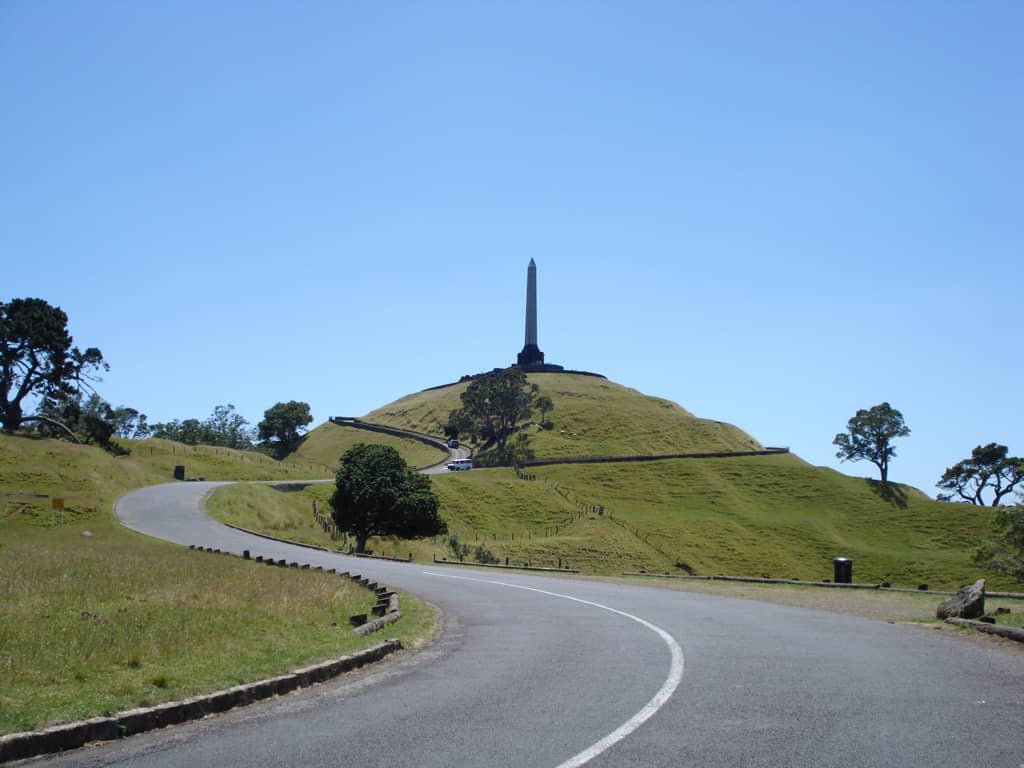
Continuing south from Maungawhau, the route passes through One Tree Hill Domain and around the base of Maungakiekie (One Tree Hill), another volcanic cone with a different character: more open, more sheep (yes, sheep still graze here), and the surrounding Cornwall Park adding shade and rest points. By the time you reach this section, afternoon light is usually best for photography of the cone silhouette.
The route finishes at Onehunga Bay Reserve on Manukau Harbour, where the water is darker and the feel is entirely different from the Waitematā end. The Auckland volcanic cones guide provides detail on the maunga you cross on this walk, including their ecological and cultural management.
How the Walk Changes by Time of Day
Morning is the most consistently rewarding time to walk. The northern harbour section sees soft light on the water between 7am and 9am, and the city noise is still building. The Domain is at its most peaceful before 10am. If you want both harbours at their photogenic best, start at the ferry terminal no later than 7:30am.
Midday walking through the volcanic section is doable but harder in summer. The open summit of Maungawhau offers no shade, and the temperature can climb considerably between December and February. Bring at least 1.5 litres of water per person and apply sunscreen before the exposed sections. The Domain and Cornwall Park have water fountains at various points.
Afternoon walkers doing sections rather than the full route find the park stretches particularly good between 3pm and 5pm, when the light softens and the summit views carry long shadows across the crater. Avoid finishing at Onehunga after dark unless you are familiar with the neighbourhood.
⚠️ What to skip
Auckland's weather changes quickly. The isthmus can move from sun to heavy rain within an hour. Carry a lightweight waterproof layer regardless of the morning forecast, especially outside summer.
Practical Walkthrough: Getting There, Getting Around, Getting Back
The northern start at the Quay Street Ferry Terminal is walking distance from Britomart Station, served by Auckland's train network. Coming by train is the most reliable option, avoiding CBD traffic and parking costs. From Britomart, walk north toward the waterfront and you will see the harbour within five minutes.
At the southern end, Onehunga Train Station sits about a ten-minute walk from the Onehunga Bay Reserve finish point. The Onehunga Line connects to the wider train network; check Auckland Transport’s journey planner at at.govt.nz for current timetables, as schedules and engineering works can affect service.
Payment on Auckland trains uses a contactless bank card, compatible device, or AT HOP card. Payment on Auckland trains uses a contactless bank card, compatible device, or AT HOP card. AT HOP cards offer fare discounts and can be topped up at train stations.
- Footwear: Trail runners or walking shoes with grip are recommended. Road shoes work on the flat sections but struggle on the volcanic cone paths, which are loose in places.
- Clothing: Layers are essential. A base layer, mid-layer, and a waterproof shell covers most Auckland conditions.
- Navigation: The route is signposted with orange Coast to Coast markers, but downloading an offline map (Google Maps or AllTrails) as a backup is sensible, especially around the Newmarket section where street-level signage is sparse.
- Water and food: Fill up at the Domain before the climb to Maungawhau. There are cafés and dairies (convenience stores) in Newmarket for snacks and water mid-route.
- Accessibility: The full route is not wheelchair-accessible due to the volcanic cone climbs and some unpaved sections. The Domain and Cornwall Park sections have paved paths suitable for most mobility levels.
Who This Walk Is Really For, and Who Should Skip It
The Coast to Coast Walkway rewards people who want to understand Auckland as a place rather than simply see its highlights. The route takes you through inner suburbs, over volcanic craters, and past the quiet back-ends of parks that tour buses never visit. It is genuinely one of the better ways to see the city's geography and history simultaneously.
Travellers with only one full day in the city should think carefully before committing to the full route. Four to five hours of walking leaves limited time for everything else, and Auckland has concentrated options for those in a hurry. A tighter one-day plan is outlined in the Auckland 3-day itinerary, which incorporates the Maungawhau summit without requiring the full walkway.
People who dislike urban walking, who are not comfortable with moderate elevation gain, or who are visiting during summer heat without early start flexibility will likely find the experience harder than rewarding. Similarly, anyone expecting a wilderness trail will be surprised: significant portions cross suburban footpaths and quiet residential streets. The scenic moments are real, but they are set within a working city.
If you want comparable views without the full commitment, the Maungawhau (Mount Eden) summit alone is worth the effort and takes under an hour return from the crater car park.
Insider Tips
- Walk north to south (Waitematā to Manukau) rather than the reverse. This puts the sun mostly behind you for the volcanic cone sections in the morning, gives you the best harbour views from Maungawhau at mid-walk, and ends with the downhill stretch into Onehunga rather than the uphill start.
- The Te Wharekura cultural space along the route is open Tuesday to Thursday, 10am–5pm, and Friday to Saturday, 10am–4pm. If your walk day aligns with those hours, factor in a stop: it offers context on the isthmus's Māori history that the orange trail markers alone cannot provide.
- The section through Newmarket is the least scenic and the easiest to rush through. That said, the Newmarket cafés are your last reliable refuelling point before the volcanic section, so treat it as a strategic stop rather than a flat stretch to grind through.
- Orange metal markers on lamp posts and fences mark the route through the suburban sections. If you have not seen a marker in more than five minutes, you have almost certainly missed a turn. This is most common around the Newmarket-to-Domain transition.
- Onehunga has a small but good café strip near the train station. After five-plus hours of walking, sitting down for coffee before catching the train back is not a luxury; it is a reasonable conclusion to the day.
Who Is Coast to Coast Walkway For?
- Urban hikers who want to understand Auckland's geography rather than just see its postcard landmarks
- History and culture enthusiasts interested in Māori settlement, volcanic landscapes, and colonial-era parks
- Photographers looking for changing light across different terrain over a single day
- Budget travellers: Budget travellers: the walk is free; the return train trip costs a train fare
- Walkers who want a structured long-distance route without leaving the city
Nearby Attractions
Combine your visit with:
- Auckland Botanic Gardens
Spread across 64 hectares in Manurewa, the Auckland Botanic Gardens offer free entry every day of the year, with themed garden collections, 10 hectares of native forest, and a visitor centre on site. It sits south of the city centre and rewards a longer visit than most people initially plan for.
- Auckland Zoo
Auckland Zoo has been part of the city's fabric since 1922, sitting in the Western Springs precinct with a collection that spans native New Zealand wildlife and international species. This guide covers everything from ticket prices and transit options to the best time of day to arrive and which exhibits deliver the most.
- Bastion Point (Takaparawhau)
Takaparawhau, known widely as Bastion Point, is a grassy headland in Ōrākei where Māori history, colonial conflict, and sweeping Waitematā Harbour views converge. It costs nothing to visit, carries centuries of significance, and rewards visitors who take time to understand what they are standing on.
- Bethells Beach (Te Henga)
Bethells Beach, officially Te Henga (Bethells Beach), is a raw, dramatic stretch of black-sand coastline about 45 minutes west of central Auckland. With rolling dunes, a freshwater lagoon, strong surf, and zero phone coverage, it delivers a genuine wilderness experience rare for a city of 1.6 million people.
Planning a trip? Discover personalized activities with the Nomado app.