Maungawhau / Mount Eden: Auckland's Volcanic Summit Worth the Climb
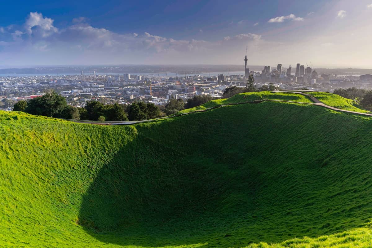
Standing 196 metres above Auckland, Maungawhau / Mount Eden is one of Auckland’s highest volcanic cones, offering uninterrupted 360-degree views from the Waitematā Harbour to the Manukau coast. Entry is free, the walking tracks are well-maintained, and the crater itself — 50 metres deep and ringed by grassy terraces — is one of the most visually striking geological features in urban New Zealand.
Quick Facts
- Location
- 250 Mount Eden Road, Mount Eden, Auckland
- Getting There
- Maungawhau Train Station (short walk); buses along Mount Eden Road
- Time Needed
- 45 minutes to 1.5 hours
- Cost
- Free admission
- Best for
- Views, geology, Māori history, photography, morning walks
- Official website
- maunga.nz/maunga/maungawhau
What Maungawhau / Mount Eden Actually Is
Maungawhau / Mount Eden is a dormant volcanic cone rising 196 metres above sea level, making it the highest volcanic cone on the Auckland isthmus (Rangitoto, offshore, is taller). The name Maungawhau translates as 'mountain of the whau tree' in te reo Māori, a reference to the native whau tree (Entelea arborescens) once abundant on its slopes. Today, the maunga is co-governed by the Tūpuna Maunga o Tāmaki Makaurau Authority, which manages all 14 of Auckland's significant volcanic cones on behalf of the city's mana whenua iwi and Auckland Council.
Geologically, the crater is the real spectacle. It drops approximately 50 metres from the crater rim, with near-perfect symmetry and steep inner walls that make it look almost engineered. The volcanic field that produced it is still considered geologically active over very long timescales, though Maungawhau itself last erupted tens of thousands of years ago. The broad summit plateau and the terraced earthworks carved into the slopes are the combined result of geological processes and human modification — Māori communities used the terraces as pā (fortified settlement) sites for centuries before European arrival.
ℹ️ Good to know
Private vehicles cannot drive to the summit. The road is closed to general traffic.
The Walk Up: What to Expect on the Ground
The main pedestrian route from the Mount Eden Road entrance is paved for most of its length, with the final approach to the summit rim becoming noticeably steeper. The path winds through open grassland, with the crater visible before you reach the top. Most reasonably fit visitors reach the summit in 15 to 20 minutes from the main gate. The surface is solid underfoot in dry weather, but can become slick after rain, so footwear with grip is worth considering.
Several tracks approach from different directions, including paths from the quieter residential streets to the north and east. These routes tend to be less trafficked than the main entrance track and offer a slightly different angle on the crater and surrounding terraces. If you want to take in the full perimeter of the summit, a loop around the crater rim adds only 10 to 15 minutes and makes a significant difference to the overall experience, giving you shifting views across both the Waitematā Harbour and the Manukau Harbour.
The crater floor and boardwalk are part of the visitor experience; please follow the posted signs and remain on designated paths.
Tickets & tours
Live prices and dates from our booking partner. If you book, we may earn a commission at no extra cost to you.
Luggage Storage in Auckland
From 5 €Instant confirmationFree cancellationNew Zealand West Coast discovery tour
From 100 €Instant confirmationFree cancellation13,000ft skydiving experience in Auckland
From 195 €Instant confirmationFree cancellationDiscover Auckland City Tour
From 88 €Instant confirmationFree cancellation
The View: What You Can Actually See
The summit provides an unobstructed 360-degree panorama across the Auckland urban area. To the north, the Sky Tower is the obvious landmark, with the Waitematā Harbour and the Hauraki Gulf beyond it. On clear days, Rangitoto Island sits unmistakably on the water — a near-perfect volcanic shield that, combined with the crater at your feet, gives the whole scene an almost surreal geological coherence.
To the south and west, the land drops toward the Manukau Harbour, and on very clear days the Waitākere Ranges are visible on the horizon. One Tree Hill (Maungakiekie), another of Auckland's significant volcanic cones, is clearly identifiable to the southeast. For context on the wider network of Auckland's volcanic landscapes, the Auckland volcanic cones guide provides a useful overview of which maunga are worth visiting and why.
The view is at its sharpest in the hour or two after early morning rain clears, when the air is washed clean and the harbour takes on a particular depth of colour. At midday in summer, haze can soften distant details considerably. Sunset from the summit is popular, particularly on evenings when cloud formations catch the light above the Waitākere Ranges.
💡 Local tip
For the clearest long-distance views, aim for early morning on a day following overnight rain. The Waitematā Harbour and Rangitoto Island are at their most defined before midday haze builds.
Time of Day: How the Experience Changes
Early mornings, especially on weekdays, offer something close to quiet at the summit. The grass is often damp, the light is low and directional, and you may have substantial stretches of the crater rim entirely to yourself. A few joggers tend to use the lower tracks before 8am, but the summit itself stays relatively uncrowded until mid-morning. This is by far the best window for photography, with shadows defining the crater walls and the city skyline catching the first direct light.
By mid-morning on weekends, the car park fills quickly and tour groups begin arriving in numbers. The summit becomes genuinely crowded between about 10am and 2pm on fine weekend days. Conversations in a dozen languages, selfie sticks, and a general sense of organised tourism are the norm during this window. The experience is still worthwhile, but it is a fundamentally different atmosphere from a quiet morning visit.
The gates close at 8:30pm in summer and 7:00pm in winter, The gates close at 8:30pm in summer and 7:00pm in winter. Evening visits offer city lights emerging as daylight fades. Evening visits carry their own character: the city lights begin to emerge while daylight is still fading, and the wind tends to drop in the late afternoon. This is probably the second-best window after early morning, particularly in autumn when the light is warm and the crowds have thinned.
Cultural and Historical Significance
Maungawhau has been a site of continuous significance to mana whenua for hundreds of years. The terraced ridges and platforms visible on the outer slopes are not natural formations — they are the remnants of extensive pā construction, where communities built defensive settlements, grew food, and maintained connections across the isthmus. Archaeological surveys have documented storage pits, terracing, and other features across the maunga's slopes. Approaching the site with that context changes how you read the landscape: the grassy terraces become something far more layered than they first appear.
The Tūpuna Maunga Authority's co-governance model, established under the Ngā Mana Whenua o Tāmaki Makaurau Collective Redress Act 2014, returned ceremonial and governance roles over 14 volcanic cones to Auckland's iwi. This is one of the more substantial examples of Treaty of Waitangi redress in an urban context in New Zealand. For visitors interested in the broader relationship between Māori culture and Auckland's landscape, the Auckland Māori culture guide offers additional context.
Getting There and Practical Logistics
The main entrance is at 250 Mount Eden Road, Mount Eden. Maungawhau Train Station is nearby, with access from Mount Eden Road or New North Road. Several Auckland Transport bus routes run along Mount Eden Road; check the AT Journey Planner before travel, as schedules and route availability can change.
The gates are open 7:00am to 8:30pm in summer and 7:00am to 7:00pm in winter, with seasonal times aligned to daylight saving. There is no admission fee. The car park at the base fills quickly on fine weekend mornings, and arriving by public transport or on foot from nearby suburbs avoids this entirely. The suburb of Mount Eden itself has several cafes within a 5-minute walk of the entrance, making a pre- or post-visit coffee straightforward to arrange.
If you are planning a broader day that includes other volcanic cones, One Tree Hill (Maungakiekie) and Mount Victoria in Devonport are both accessible on the same day and offer contrasting perspectives on the city.
Photography Tips and Accessibility
The crater photographs best in the early morning, when low-angle light creates shadow definition in the crater walls and the concentric terracing becomes visible. A wide-angle lens captures the full crater from the rim, but some of the most striking images come from shooting across the crater with the city skyline beyond it — a composition that requires positioning on the northern rim. The Sky Tower appears above the crater bowl from this angle, which conveys the geological scale of the site relative to the built environment.
The summit path is paved but steep in the upper section. The summit path is paved but steep in the upper section. Dogs are permitted on leads in some areas of the park; check the Tūpuna Maunga Authority website for current rules, as conditions can change.Dogs are permitted on leads in some areas of the park; check the Tūpuna Maunga Authority website for current rules, as conditions can change.
⚠️ What to skip
Wind at the summit can be significantly stronger than at street level. A light layer is useful even on warm days, particularly in the morning or near sunset when temperatures drop quickly at elevation.
Honest Assessment: Who Should Skip This
If your primary interest is interactive experiences, indoor exhibits, or café culture, Maungawhau will feel sparse. There are no facilities at the summit, no interpretive displays, and no shelter. The experience is entirely about landscape and open space. Visitors who struggle with moderate inclines and do not have mobility-access arrangements will find the upper section genuinely challenging. And if you are visiting Auckland during a stretch of overcast weather without cloud breaks, the views will be substantially diminished — the 360-degree panorama that justifies the climb simply does not materialise in heavy low cloud.
For visitors primarily interested in structured heritage interpretation, the Auckland War Memorial Museum in the Domain offers a more comprehensive introduction to both Māori history and Auckland's volcanic geology, with labelled exhibits and context that the open hillside at Maungawhau does not provide.
Insider Tips
- Walk the full perimeter of the crater rim rather than stopping at the first viewpoint. The southern rim gives you a completely different sightline, including a clear view toward the Manukau Harbour that most visitors miss.
- Arrive via one of the quieter residential approach tracks from the east side of Maungawhau — these add a few minutes to the walk but avoid the main entrance crowd entirely on busy weekend mornings.
- The wind direction matters for photography. The crater wall shadows are sharpest on the western side in the morning and the eastern side in the late afternoon. Plan your shooting position accordingly.
- The suburb of Mount Eden has some of Auckland's better independent cafes concentrated within a few blocks of the entrance. Combining the walk with breakfast or post-hike coffee at one of these makes the outing significantly more enjoyable than heading straight back to the CBD.
- On days when Auckland has low cloud hanging below 200 metres, Maungawhau's summit can sit just above the cloud layer, giving an entirely different atmospheric experience. This is unpredictable but worth checking the forecast for.
Who Is Mount Eden (Maungawhau) For?
- Photographers looking for wide city panoramas and volcanic crater compositions
- Visitors wanting a free, high-reward outing that requires minimal planning
- Travellers interested in Māori history and Auckland's pre-colonial landscape
- Early risers who want a morning walk with genuine payoff before the crowds arrive
- Anyone doing a multi-cone day and building a sense of Auckland's volcanic geography from the ground up
Nearby Attractions
Combine your visit with:
- Auckland Botanic Gardens
Spread across 64 hectares in Manurewa, the Auckland Botanic Gardens offer free entry every day of the year, with themed garden collections, 10 hectares of native forest, and a visitor centre on site. It sits south of the city centre and rewards a longer visit than most people initially plan for.
- Auckland Zoo
Auckland Zoo has been part of the city's fabric since 1922, sitting in the Western Springs precinct with a collection that spans native New Zealand wildlife and international species. This guide covers everything from ticket prices and transit options to the best time of day to arrive and which exhibits deliver the most.
- Bastion Point (Takaparawhau)
Takaparawhau, known widely as Bastion Point, is a grassy headland in Ōrākei where Māori history, colonial conflict, and sweeping Waitematā Harbour views converge. It costs nothing to visit, carries centuries of significance, and rewards visitors who take time to understand what they are standing on.
- Bethells Beach (Te Henga)
Bethells Beach, officially Te Henga (Bethells Beach), is a raw, dramatic stretch of black-sand coastline about 45 minutes west of central Auckland. With rolling dunes, a freshwater lagoon, strong surf, and zero phone coverage, it delivers a genuine wilderness experience rare for a city of 1.6 million people.
Planning a trip? Discover personalized activities with the Nomado app.