Takarunga / Mount Victoria: Devonport's Best Viewpoint
Takarunga / Mount Victoria rises 66 metres above the Devonport foreshore, offering some of the most photogenic views of Auckland's harbour and skyline. Free to visit and easy to reach by ferry, it rewards the short climb with panoramas that stretch from Rangitoto Island to the CBD and beyond.
Quick Facts
- Location
- Devonport, North Shore Auckland. Walking route starts at 29 King Edward Parade; visitor parking at 16 Kerr Street.
- Getting There
- Catch a Devonport Ferry from Auckland's downtown Ferry Terminal (Downtown, Quay Street). The summit is a 10–15 min walk from the Devonport wharf.
- Time Needed
- 45–90 minutes including the walk up, time at the top, and descent.
- Cost
- Free to enter. Ferry fares apply (Auckland Transport standard adult fare; AT HOP card accepted).
- Best for
- Harbour views, photography, volcano history, Devonport day trips, families with older children.
What Is Takarunga / Mount Victoria?
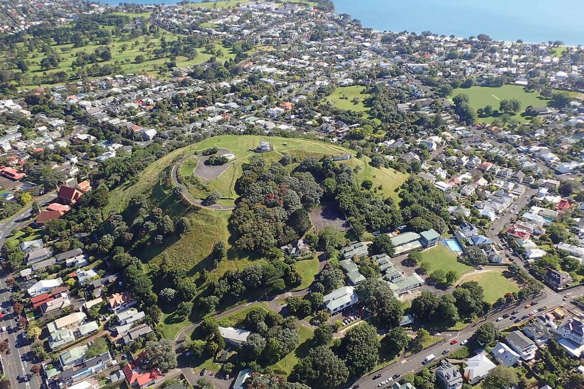
Takarunga / Mount Victoria is a 66-metre volcanic cone sitting at the heart of the Devonport peninsula on Auckland's North Shore. Its Māori name, Takarunga, translates loosely as 'the hill standing above' — an apt description for a summit that commands unobstructed sightlines across the Waitemata Harbour, out to Rangitoto Island, and back across the water toward the Auckland CBD skyline. The hill is an Auckland Council public reserve, free to enter, and accessible on foot year-round.
This is This is one of Auckland’s volcanic cones, each one a taonga (treasured landmark) in the cultural landscape of Tāmaki Makaurau., each one a taonga (treasured landmark) in the cultural landscape of Tāmaki Makaurau. Unlike the more heavily trafficked Maungawhau / Mount Eden in the city, Takarunga sits at a quieter remove across the harbour, which shapes the visit considerably. You arrive by ferry, walk through a historic seaside suburb, and climb a cone that feels genuinely local rather than tourist-packaged.
ℹ️ Good to know
The summit road is closed to private motor vehicles. The only way up is on foot, which keeps the top pleasantly calm even when the ferry brings a wave of visitors to Devonport below.
Getting There: The Ferry and the Walk
The standard approach is the Devonport Ferry from Auckland's downtown Ferry Terminal on Quay Street. Ferries run regularly throughout the day and the crossing takes around 12 minutes. AT HOP cards are accepted; contactless debit and credit cards work on most services too. Check the Auckland Transport journey planner for current timetables before you go, as schedules can change.
From the Devonport wharf, the summit is about a 10–15 minute walk. The clearest route heads along King Edward Parade, then up Church Street, left onto Kerr Street, and follows the signed track to the top. If you're planning a full North Head Historic Reserve loop — If you're planning a full loop — another volcanic cone and former military site nearby — you can combine both into a half-day without retracing steps. — you can combine both into a half-day without retracing steps.
The walk itself is short but not entirely flat. The final section up to the summit has a reasonable gradient on a formed path, and the surface can be slippery after rain. Wear shoes with some grip. There is no general step-free walking route to the summit; visitors with limited mobility should check current access arrangements before visiting., so visitors with limited mobility should check conditions before visiting.
Tickets & tours
Live prices and dates from our booking partner. If you book, we may earn a commission at no extra cost to you.
Luggage Storage in Auckland
From 5 €Instant confirmationFree cancellationNew Zealand West Coast discovery tour
From 100 €Instant confirmationFree cancellation13,000ft skydiving experience in Auckland
From 195 €Instant confirmationFree cancellationDiscover Auckland City Tour
From 88 €Instant confirmationFree cancellation
The View From the Top
The summit is open and grassy, ringed by a walking track that circles the crater rim. From here the whole geometry of Auckland's geography clicks into place: the harbour curves south toward the CBD, the Sky Tower punctuates the city skyline, and Rangitoto Island sits in profile to the northeast, its perfectly symmetrical cone giving away its volcanic origin. On a clear day, the Coromandel Peninsula is visible to the southeast and the Waitakere Ranges frame the western horizon.
The light changes dramatically by time of day. Morning visits reward you with the CBD skyline catching the eastern sun, and the harbour tends to be calm before sea breezes build in the early afternoon. Late afternoon turns the water into glinting copper and the city silhouette sharpens as shadows lengthen. At dusk, the view toward the CBD transforms again as city lights begin to reflect across the harbour — though you'll need to check the ferry schedule carefully if you plan to stay that late.
💡 Local tip
For photography: a wide-angle lens or a phone's panoramic mode works well at the summit. The best composition puts Rangitoto Island over your left shoulder and the Sky Tower to the right, with the harbour in between. Midday light is flat and harsh; aim for before 10 am or after 4 pm.
History: Signal Station, Reserve, and Military Use
Takarunga carries significant historical layers. A signal station was established here in 1841 — among the earliest colonial communication infrastructure in the young settlement of Auckland. Ships entering the Waitemata Harbour could be sighted from the summit and signals relayed to the town below, making it a practical navigation aid in an era before radio.
The hill became a public reserve in 1880, a relatively early designation that speaks to how obvious its value as open space was even to 19th-century planners. The ridge connecting Takarunga to North Head (Maungauika) was used for military purposes, and the area's strategic position above the harbour entrance gave it importance across several eras of New Zealand's colonial and defence history. Tunnels and fortifications associated with that military history are concentrated at North Head rather than Takarunga itself, but the two sites are best understood together.
For a deeper understanding of Auckland's volcanic landscape — and why cones like Takarunga matter ecologically and culturally — the Auckland volcanic cones guide covers the broader context across the isthmus.
What the Visit Actually Feels Like
Devonport has a low-key pace that distinguishes it from the Auckland waterfront. The streets leading to the summit are lined with wooden villas, small cafés, and the occasional bookshop. The walk up Kerr Street is quiet by urban standards; you'll likely hear tūī calling in the trees before the vegetation thins near the crater rim. The summit itself is exposed — wind is a constant variable, and even on warm days a layer is worth bringing. There are no facilities at the top: no café, no shelter, no toilets.
Crowds are manageable by Auckland standards. On a busy summer weekend, the summit might hold a few dozen people at any one time, but it never feels congested. Weekday mornings are the quietest. After a ferry arrival, expect a small cluster of visitors to head up simultaneously; give it 15 minutes and the top usually thins out again. The experience is genuinely calm compared with more visited volcanic cones closer to the CBD.
The neighbourhood below is worth exploring before or after the climb. Devonport's main street has decent coffee, and the foreshore along Devonport offers good water-level views back across to the city. If you have extra time, combining the climb with lunch and a wander through the village is a natural half-day structure.
Weather, Timing, and Practical Preparation
Auckland's maritime climate means rain can arrive quickly, and Takarunga's exposed summit amplifies wind significantly. A clear morning can turn overcast by early afternoon; checking a short-range forecast before you leave the ferry terminal is sensible. The track becomes muddy and slippery after rain, especially on the final ascent. If conditions look marginal, North Head's partially covered tunnels offer an alternative if rain catches you.
Summer (December to February) brings the longest daylight hours and the best chance of clear visibility, but also more visitors on the ferries. Autumn (March to May) is often considered the most settled season in Auckland, with stable weather and fewer crowds — an excellent time for this kind of outdoor excursion. Winter visits are perfectly feasible on clear days and the cool air can actually improve visibility, though southerly winds at the summit can be biting.
⚠️ What to skip
There are no toilets or drinking water facilities at the summit. Use facilities at the Devonport ferry terminal or in the village before you head up. Bring water, especially in summer.
Who Should Think Twice
If you're visiting Auckland on a very short itinerary and the harbour is the main draw, the ferry crossing and summit walk adds about two to three hours to your day once ferry wait times are factored in. Visitors with significant mobility challenges will find the summit track difficult, as no confirmed step-free route exists. Those who have already visited Maungawhau / Mount Eden expecting a different experience may find the views from Takarunga broadly comparable — though the perspective across the harbour rather than from within the city is genuinely distinct.
If panoramic city views are the primary goal and the ferry feels like too much investment in time, the Auckland Sky Tower delivers a 360-degree elevated view without leaving the CBD. Takarunga's appeal is different in character: it is a natural summit, free, set in a historic suburb, and part of an outdoor half-day rather than a quick tick.
Insider Tips
- Check the ferry timetable in both directions before you set out. The last evening ferry to Devonport typically runs until late, but if you're planning a sunset visit, confirm departure times so you're not stranded on the wrong side of the harbour.
- The crater rim walking track circles the full summit — do the full loop rather than heading straight to the obvious viewpoint. The southern side opens up a different angle across the inner harbour and toward the North Shore suburbs.
- Combining Takarunga with North Head (Maungauika) makes for a satisfying half-day walk. Combining Takarunga with North Head (Maungauika) makes for a satisfying half-day walk. The sites can be combined using Devonport’s walking routes, and the contrast between the open summit views and North Head's tunnel network gives the visit extra depth. and the contrast between the open summit views and North Head's tunnel network gives the visit extra depth.
- Locals use the summit track for morning exercise, which means the path is busiest between 7 and 9 am on weekdays. If you arrive on the first or second morning ferry, you'll be sharing the track with regulars who know it well — and the light is excellent for photography at that hour.
- The village's café scene is concentrated on Victoria Road. For coffee before the climb or a meal after, aim for early arrival on weekends as popular spots fill quickly after the mid-morning ferry wave.
Who Is Mount Victoria (Devonport) For?
- Travellers doing a Devonport day trip who want more than cafés and the foreshore
- Photography enthusiasts chasing the harbour-skyline composition that city-based viewpoints cannot replicate
- Families with children old enough to manage a short, moderately steep trail
- Visitors interested in Auckland's volcanic landscape and 19th-century colonial history
- Anyone wanting a genuinely free, outdoor experience Anyone wanting a genuinely free, outdoor experience within a short ferry trip of the CBD
Nearby Attractions
Other things to see while in Devonport:
- North Head Historic Reserve
Perched above Devonport on Auckland's North Shore, Maungauika / North Head Historic Reserve combines a volcanic cone formed over 50,000 years ago with a network of 19th-century military tunnels and gun batteries. The reserve is free to enter, easy to reach by ferry, and rewards visitors with some of the finest panoramic views over the Waitematā Harbour and Hauraki Gulf.
Planning a trip? Discover personalized activities with the Nomado app.