Maungauika / North Head Historic Reserve: Devonport's Volcanic Fortress with Harbour Views
Perched above Devonport on Auckland's North Shore, Maungauika / North Head Historic Reserve combines a volcanic cone formed over 50,000 years ago with a network of 19th-century military tunnels and gun batteries. The reserve is free to enter, easy to reach by ferry, and rewards visitors with some of the finest panoramic views over the Waitematā Harbour and Hauraki Gulf.
Quick Facts
- Location
- 18 Takarunga Road, Devonport, Auckland (start path at 2 Cheltenham Road)
- Getting There
- Ferry from Auckland's downtown terminal to Devonport, then roughly 15 min on foot
- Time Needed
- 1.5–2.5 hours for a relaxed explore including tunnels and summit
- Cost
- Free entry (no admission fee)
- Best for
- History lovers, panoramic photography, family half-days, walkers
- Official website
- maunga.nz/maunga/maungauika
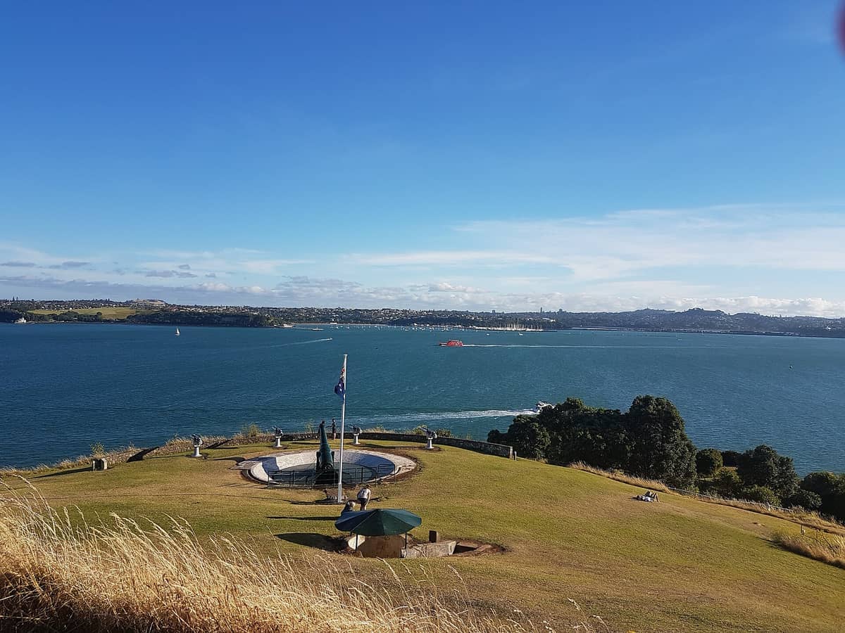
What Is Maungauika / North Head?
Maungauika / North Head Historic Reserve is a volcanic headland at the southern tip of Devonport, one of Auckland's most historically layered outdoor spaces. The maunga (mountain) formed in a series of volcanic eruptions over 50,000 years ago, and its distinctive silhouette has shaped the skyline of the upper Waitemata Harbour ever since. For Māori, Maungauika holds deep ancestral significance. For the colonial administration of the 1880s, it was a strategic military asset: the commanding height and direct sightlines to the harbour entrance made it the obvious place to construct Auckland's coastal defences.
Today the reserve is managed by the Tūpuna Maunga o Tāmaki Makaurau Authority, which oversees Auckland's significant volcanic cones as shared cultural and natural heritage. That dual identity, part ancient geological feature, part Victorian-era fortress, gives Maungauika a depth that most viewpoints in the region simply cannot match. You are not just looking at a view. You are standing on layers of history that stretch from pre-European settlement through two World Wars.
Devonport itself is worth building a half-day around. The Devonport village below the reserve has good cafés, heritage streetscapes, and a relaxed pace that contrasts sharply with central Auckland. Combining North Head with nearby Mount Victoria (Takarunga) makes for a satisfying morning or afternoon without needing to rush.
The Military Tunnels and Gun Emplacements
The headline feature for most visitors is the network of tunnels linking the batteries and service facilities, many excavated by prisoners between 1888 and 1914, after a muzzle-loader fort was installed in 1885. Three disappearing-gun batteries were installed, designed so that heavy artillery could be raised to fire, then lowered below the parapet to reload, concealed from enemy ships. The mechanisms are long gone, but the circular gun pits, concrete platforms, and brick-lined magazines survive in remarkably good condition.
Walking into the tunnels for the first time is genuinely atmospheric. The rock walls are cool and slightly damp regardless of the weather outside, and the low ceilings mean taller visitors will want to watch their heads. Bring a torch or use your phone light: some passages receive no natural light at all, and the darkness deepens around corners in a way that is worth experiencing rather than bypassing. Children find the tunnel system endlessly explorable, and the open gun pits at the surface give a clear sense of how the batteries once commanded the harbour approaches.
💡 Local tip
Bring a torch or switch on your phone flashlight before entering the tunnels. Some interior sections are genuinely dark, and the uneven rock floor can be slippery if you cannot see where you are stepping.
The military use of the site continued well into the 20th century. Additional fortifications were added during World War II, and the reserve still contains searchlight emplacements, underground store rooms, and concrete observation posts from that era. Reading the layers from 1880s brick to 1940s reinforced concrete is its own quiet history lesson. Information panels are positioned throughout, but they do not over-explain. The structures speak clearly enough on their own.
Tickets & tours
Live prices and dates from our booking partner. If you book, we may earn a commission at no extra cost to you.
Luggage Storage in Auckland
From 5 €Instant confirmationFree cancellationNew Zealand West Coast discovery tour
From 100 €Instant confirmationFree cancellation13,000ft skydiving experience in Auckland
From 195 €Instant confirmationFree cancellationDiscover Auckland City Tour
From 88 €Instant confirmationFree cancellation
The Summit and Panoramic Views
The summit of Maungauika sits above sea level, which sounds modest until you are standing on it. The viewshed is exceptional because the headland is surrounded on three sides by water, with no high ground immediately adjacent to interrupt the sightlines. To the south lies the Waitemata Harbour, with the Auckland CBD skyline and Sky Tower clearly visible across the water. To the east, the Hauraki Gulf spreads out toward Rangitoto Island's perfectly conical volcanic profile. To the north and west, the Devonport peninsula and North Shore stretch away into the distance.
Rangitoto is the obvious focal point from the summit and deserves more than a glance. The island, which erupted around 600 years ago, is Auckland's youngest volcanic cone. If the view from North Head tempts you closer, the Rangitoto Summit Track is one of the region's most rewarding half-day hikes, accessible by ferry from downtown Auckland.
The light changes the experience significantly. In the morning, the CBD catches the sun from the east and the harbour surface reflects hard silver light. In the late afternoon, the whole scene shifts to gold and the shadows across the gun pits grow long. Photographers consistently find the north-facing summit position around an hour before sunset produces the most dramatic results, with warm light on the water and the city skyline still bright against the western sky. Overcast days are not a write-off: the softer light reduces glare from the harbour and makes for cleaner wide shots without blown highlights.
How to Get There and When to Visit
The most practical approach is the Devonport ferry from downtown Auckland, operated by Auckland Transport. Check Auckland Transport for current departure pier and crossing times. From the Devonport Ferry Terminal, North Head is roughly a 15-minute walk through the village and along the foreshore. Auckland Council suggests beginning the reserve path at 2 Cheltenham Road rather than approaching directly from the main road. The walk to the start of the path passes Cheltenham Beach, which adds a pleasant coastal stretch to the approach.
ℹ️ Good to know
Vehicle access hours: 6 am–8 pm in summer, 7 am–7 pm in winter. Pedestrian access hours: 6 am–10 pm in summer, 7 am–8:30 pm in winter. Always check current hours with Auckland Council before planning an evening visit.
The reserve is open year-round, but the experience differs substantially by season. Summer (December to February) brings long daylight hours, warm temperatures, and larger crowds, particularly on weekends and public holidays. Arriving before 9 am or after 3 pm during summer avoids the peak crush. Autumn and spring, roughly March to May and September to November, offer more consistent conditions with fewer visitors, and the morning mist that sometimes settles over the harbour in those months adds a cinematic quality to the summit view. Winter visits are quieter still, though the earlier closing times for vehicle access mean walkers should plan accordingly.
For the broader context of getting around the North Shore and planning your day, the getting around Auckland guide covers ferry timetables, AT HOP card payments, and connections between Devonport and the rest of the city.
Practical Walkthrough: What to Expect on the Ground
The reserve has no entry gate or ticket booth. You simply walk in and begin exploring. The main sealed path winds up from the Cheltenham Road entrance, suitable for prams and pushchairs according to Auckland Council, though some steeper sections require effort. A direct route to the summit uses stairs, which is faster but not suitable for wheeled transport. Most visitors spend around 20 to 30 minutes reaching the summit, then additional time exploring the tunnels and gun platforms on the way back down.
There are no cafés, kiosks, or water fountains within the reserve, so bring your own water, especially in summer. The terrain is partially exposed, with the summit and eastern gun platforms offering little shade. Sunscreen and a hat matter more than you might expect for what looks like a short outing. Footwear with some grip is advisable if you plan to explore the tunnel interiors, where the floor can be uneven and damp. The sealed paths are fine in ordinary shoes.
⚠️ What to skip
There are no facilities inside the reserve: no toilets, no water, no food. Use facilities in Devonport village before you head up, and carry your own water.
Dogs are permitted on the maunga when kept under control on leash, in keeping with the Tūpuna Maunga Authority's management rules. This is worth knowing if you are travelling with a dog or planning to pick up a four-legged companion during your Devonport visit.
Cultural Significance and Honest Assessment
Maungauika carries cultural weight beyond its military history. As a maunga of Tāmaki Makaurau, it is part of a network of volcanic cones regarded as tūpuna (ancestors) by Māori. The Tūpuna Maunga Authority, established under Treaty of Waitangi settlement legislation, co-governs the site alongside Auckland Council. This context matters when you visit: the land is not simply a public park. It is a place of deep ancestral connection, and the management approach reflects that. Interpretive panels acknowledge Māori history alongside the colonial military history.
For visitors with a specific interest in Auckland's Māori history and its volcanic landscape, the Auckland Māori culture guide and the guide to Auckland's volcanic cones provide substantially more background on the mana whenua connection to these sites and how to engage respectfully.
In terms of honest assessment: North Head is not a polished, guided experience. There is no museum, no audio tour, no organised program. What you get is a genuine historic landscape that rewards curiosity and self-directed exploration. Visitors who prefer structured interpretation or who are uncomfortable in dim, confined spaces may find the tunnels less satisfying than the summit views. But for anyone with even a passing interest in military history, geology, or simply wide-open harbour panoramas, the reserve delivers something that is difficult to find elsewhere in the Auckland region, entirely for free.
If panoramic views across Auckland's harbour and gulf are a priority on your trip, cross-reference the best views in Auckland guide to compare North Head against other vantage points including the Sky Tower and Mount Eden.
Insider Tips
- The eastern gun pits, lower on the headland toward Cheltenham Beach, are often overlooked by visitors who head straight for the summit. These lower emplacements have the clearest surviving infrastructure and These lower emplacements have the clearest surviving infrastructure and the best close-up details of the historic construction..
- If you visit on a clear morning, bring binoculars. The Rangitoto Summit, the Waiheke Island ferry wake, and the container ships rounding North Head on their way into the Waitemata are all clearly visible and far more interesting when you can actually see them.
- The sealed path down toward Cheltenham Beach on the northeast side of the reserve is quieter than the main approach route and passes through native planting. It makes a better return loop than retracing your steps.
- Weekday mornings, especially Tuesday through Thursday, see the lightest visitor numbers. School holiday periods in January and April bring significantly more families, which makes the tunnel exploration feel crowded.
- Combine your visit with a morning swim at Cheltenham Beach immediately below the reserve. The beach is sheltered, rarely crowded before 10 am, and provides a clean finish to an active Devonport morning.
Who Is North Head Historic Reserve For?
- History and military heritage enthusiasts who want to explore genuine 1880s and WWII fortifications without museum-level curation
- Photographers looking for harbour panoramas with foreground interest and accessible golden-hour positions
- Families with children who are comfortable in semi-dark tunnel spaces and enjoy unstructured outdoor exploration
- Walkers combining North Head with Mount Victoria (Takarunga) and Cheltenham Beach for a half-day Devonport circuit
- Budget-conscious travellers who want a genuinely rewarding Auckland experience at zero cost beyond the ferry fare
Nearby Attractions
Other things to see while in Devonport:
- Mount Victoria (Devonport)
Takarunga / Mount Victoria rises 66 metres above the Devonport foreshore, offering some of the most photogenic views of Auckland's harbour and skyline. Free to visit and easy to reach by ferry, it rewards the short climb with panoramas that stretch from Rangitoto Island to the CBD and beyond.
Planning a trip? Discover personalized activities with the Nomado app.