Rangitoto Summit Track: Walking to the Top of Auckland's Youngest Volcano
The Rangitoto Summit Track is a 7 km return walk across New Zealand's largest lava field to the rim of a 260-metre shield volcano that last erupted around 600 years ago. Reached by ferry from central Auckland, it rewards hikers with some of the most expansive views in the Hauraki Gulf region. The terrain is raw, uneven, and utterly unlike anything else in the Auckland day-trip circuit.
Quick Facts
- Location
- Rangitoto Island, Hauraki Gulf, Auckland
- Getting There
- Public ferry from Downtown Ferry Terminal (~25 min) or Devonport (~20 min) to Rangitoto Wharf; check Fullers360 for current timetables and fares
- Time Needed
- Allow at least 3.5 hours including ferry crossing and summit walk
- Cost
- Ferry fare applies (verify current prices with Fullers360 or Auckland Transport); no admission charged for the track itself
- Best for
- Geology lovers, view-seekers, half-day adventurers, photographers
What Is the Rangitoto Summit Track?
The Rangitoto Summit Track is the main walking route to the crater rim of Rangitoto, the youngest and biggest volcano in the Auckland Volcanic Field, in the Hauraki Gulf Marine Park. The island's Māori name, Ngā Rangi-i-totongia-a Tama-te-kapua, translates roughly as 'the days of the bleeding of Tama-te-kapua', a reference embedded in oral history. The island itself erupted approximately 600 years ago and is remarkable for still looking the part: vast fields of black lava rock, skeletal pohutukawa clinging to fissures, and a summit crater that is 60 metres deep.
The route is 7 km return with around 250 metres of ascent. The Department of Conservation (DOC) grades it easy to intermediate, which is broadly accurate for fit walkers, though the terrain is consistently rough. Loose scoria, uneven lava plates, and exposed tree roots mean you need solid footwear and steady footing at every step. This is not a path for sandals or casual shoes.
⚠️ What to skip
Wear sturdy, closed-toe shoes with ankle support. The lava rock is uneven the entire way and there is no prepared surface on most of the track. Flip-flops and sneakers significantly increase the risk of rolled ankles.
The Walk: What You'll Actually Experience
From Rangitoto Wharf, the track begins with a flat, shaded walk through coastal pohutukawa forest. Within 10 minutes the canopy opens and the lava field begins in earnest. The scale surprises first-time visitors: black rock stretches in every direction, fractured and stacked in uneven layers, with only thin fingers of vegetation breaking through. The pohutukawa here have evolved to grow in conditions that would defeat most trees, sending roots down through lava cracks to reach soil and water metres below. On a warm day, heat radiates off the dark rock and the air smells faintly mineral, like wet stone after rain.
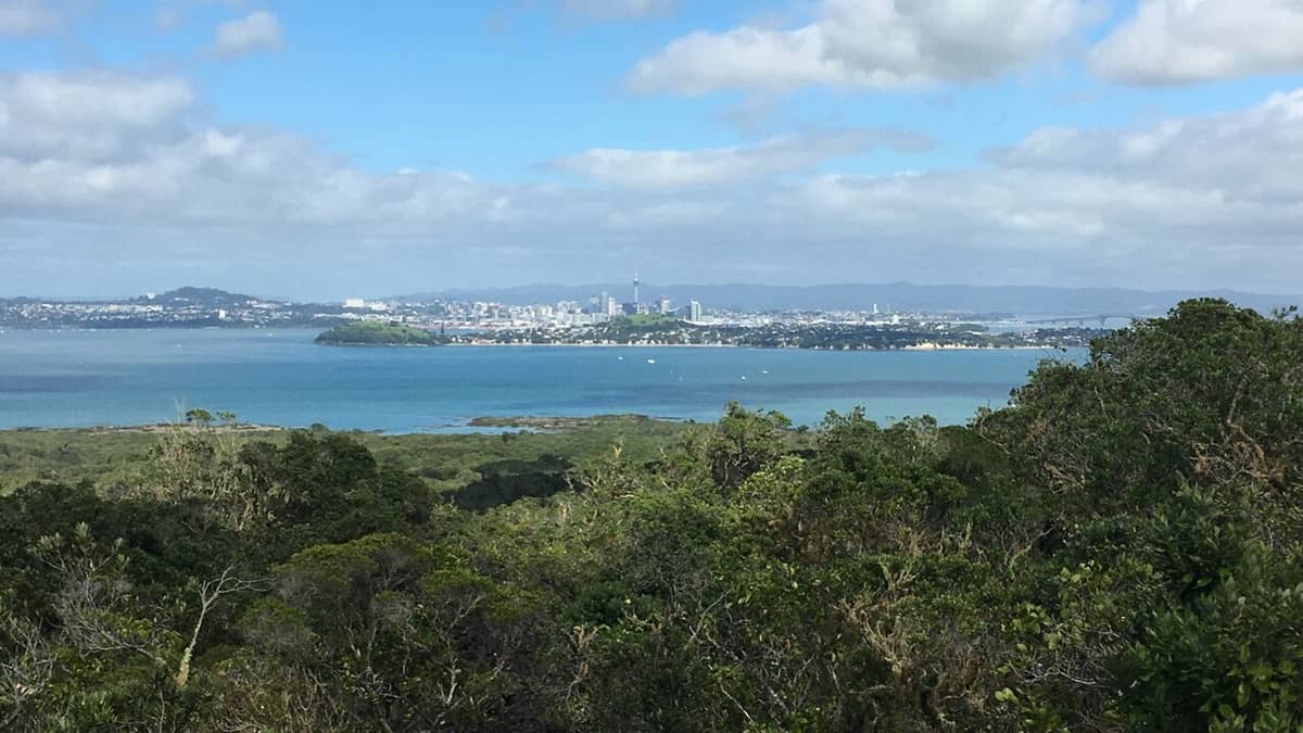
The gradient steepens about halfway through, where steps cut into the scoria help with the ascent. The trees thin further and the wind picks up. By the time you reach the summit lookout, the full arc of the Hauraki Gulf opens in front of you: Waiheke Island to the south-east, the Coromandel Peninsula on the distant horizon, and the Auckland skyline to the west with the Sky Tower clearly visible. On a clear day the view extends north to Great Barrier Island. There is a defined crater rim walk that adds a short loop at the top, allowing you to look down into Rangitoto’s 60-metre-deep crater.
For those interested in the broader volcanic story across Auckland, the Auckland volcanic cones guide provides helpful context on how Rangitoto fits into the wider Auckland Volcanic Field, which contains over 50 separate volcanoes.
Tickets & tours
Live prices and dates from our booking partner. If you book, we may earn a commission at no extra cost to you.
Luggage Storage in Auckland
From 5 €Instant confirmationFree cancellationNew Zealand West Coast discovery tour
From 100 €Instant confirmationFree cancellation13,000ft skydiving experience in Auckland
From 195 €Instant confirmationFree cancellationDiscover Auckland City Tour
From 88 €Instant confirmationFree cancellation
Time of Day: How the Experience Changes
Morning departures on the first or second ferry are the clear choice for most walkers. The light is softer, the track is cooler, and you will almost certainly have long stretches of the path to yourself. By late morning, the volume of visitors on the track picks up noticeably. Groups from tour operators and school trips tend to arrive mid-morning, and the narrower sections near the summit can become congested.
Midday in summer is genuinely harsh on the open lava field. There is no shade on the upper half of the track, and the black rock amplifies the heat. Carrying at least 1.5 litres of water per person is not optional during warmer months. Late afternoon ferry options exist, but check return times carefully before committing; missing the last ferry back to Auckland is a predictable consequence of underestimating the walk or forgetting to check the schedule.
💡 Local tip
Aim to be on the first or second ferry of the day. You'll reach the summit before the main crowd arrives, and the softer morning light makes for significantly better photographs of the lava fields and Gulf views.
History and Cultural Context
Rangitoto is significant in Māori oral history and was used by iwi of the region both before and after the eruption period. European settlement on the island was limited. The island’s historic tracks and infrastructure reflect its changing use over time.
The island also served a military role, forming part of Auckland's harbour defences from 1935 to 1957. Remnants of this history are visible in structures near the coastline, though the focus on the summit track keeps most visitors away from these sites unless they explore further. The Rangitoto Island Historic Conservation Trust maintains detailed documentation of the island's layered past.
Ecologically, Rangitoto hosts the world's largest pohutukawa forest. The tree's ability to colonise raw lava has made this island a reference point for botanical research into plant succession on volcanic substrates. Walking the track is, in a quiet way, walking through one of New Zealand's most instructive examples of ecosystem formation.
Getting There: Ferries and Logistics
The ferry to Rangitoto departs from Downtown Ferry Terminal at 99 Quay Street in central Auckland. The crossing takes approximately 25 minutes. From Devonport, on the North Shore, a separate service takes around 20 minutes. Fullers360 operates services to Rangitoto; Auckland Transport's journey planner and the Fullers360 website are the authoritative sources for current timetables and pricing, both of which change seasonally. Always verify the last return ferry before you step ashore, and factor in that the walk and time at the summit will take most people 2.5 to 3.5 hours.
If you're combining the trip with a broader island-hopping day, the Hauraki Gulf islands guide covers other accessible islands in the same Gulf, some of which can be reached on day-trip ferry circuits.
ℹ️ Good to know
No accommodation exists on Rangitoto Island, and overnight camping is not permitted. This is a day-visit destination. Plan your ferry times carefully and confirm the last return sailing before departing Auckland.
Photography, Accessibility, and What to Bring
The photographic opportunities on this track are substantial and varied. The lava field texture is extraordinary in low-angle light, making early morning or late afternoon the best windows for close-up detail shots of the rock surface. At the summit, the panoramic view justifies a wide-angle lens or a phone panorama, but haze is common in summer so telephoto shots of distant islands may disappoint on warm days. The pohutukawa forest near the shore photographs well in dappled midday light when the canopy filters the sun.
Accessibility is limited. The track surface is entirely unsuitable for wheelchairs or prams. There are no accessible toilet facilities on the track. A basic toilet block is available near the wharf area. DOC's easy-to-intermediate grading reflects the low elevation gain rather than the surface quality; for visitors with knee or hip issues, the rough terrain may be more demanding than that rating suggests.
- Water: minimum 1.5 litres per person, more in summer
- Footwear: sturdy closed-toe shoes with ankle support, ideally hiking boots
- Sun protection: hat, sunscreen, and sunglasses for the fully exposed upper track
- Snacks: there is no food available on the island; bring your own
- Ferry schedule: a screenshot or printout of return times, especially in areas with poor cell reception
- Light layer: wind on the summit rim can drop the temperature quickly, even on warm days
Managing Expectations: Who This Walk Is and Isn't For
The Rangitoto Summit Track delivers on its core promise: a genuine volcanic landscape and a genuinely wide view. It is not, however, a manicured experience. The track is uneven from start to finish, there are no cafés or facilities on the island beyond basic toilets near the wharf, and the walk itself is straightforward rather than dramatic. Visitors expecting the kind of curated, signage-heavy nature walk found in urban parks may find it underwhelming. Those who arrive with an interest in geology, ecology, or open views above water will almost certainly find it worth the effort.
Rangitoto makes an excellent pairing with a trip to nearby Rangitoto's lava caves, which are accessible via a short side track on the island and add genuine geological interest to the visit without significantly extending the day.
For travellers with limited time in Auckland who want to compare options, the best hikes in Auckland guide places the summit track in context alongside other routes accessible from the city.
Insider Tips
- Take the earliest available ferry. The track is a different experience before 10 am: quieter, cooler, and lit better for photography. By late morning the main wave of visitors arrives and the narrow upper sections feel congested.
- The lava caves side track branches off the main route partway up. Most first-timers miss it entirely. Allow about 30 minutes for the out-and-back walk, plus time to explore, and bring a torch — it is worth the diversion if you have the time.
- Do not rely on mobile data for ferry times once on the island. Cell coverage is patchy. Screenshot the return timetable before you leave the wharf.
- The summit view is significantly better in autumn and spring. Summer haze regularly obscures the Coromandel Peninsula and makes Great Barrier Island invisible from the crater rim.
- The pohutukawa bloom in December and January. If you time a visit for early-to-mid December, the coastal forest near the wharf is covered in red flowers, and the contrast with the black lava is striking.
Who Is Rangitoto Summit Track For?
- Geology and volcanology enthusiasts looking for a tactile encounter with a geologically young landscape
- View-seekers who want a Hauraki Gulf panorama earned on foot rather than from a café terrace
- Half-day adventurers based in Auckland wanting a genuine outdoor experience without a long drive
- Nature photographers drawn to texture, contrast, and dramatic light on volcanic rock
- Travellers with older children who are confident on uneven terrain and can manage a 7 km walk
Nearby Attractions
Other things to see while in Rangitoto Island:
- Rangitoto Lava Caves
The Lava Caves Track on Rangitoto Island leads you through naturally formed volcanic tunnels beneath the island's ancient lava fields. Free to enter and relatively short, the caves add a genuinely different dimension to a Rangitoto day trip — one that most visitors overlook entirely.
Planning a trip? Discover personalized activities with the Nomado app.