Bastion Point (Takaparawhau): Auckland's Most Historically Charged Viewpoint
Takaparawhau, known widely as Bastion Point, is a grassy headland in Ōrākei where Māori history, colonial conflict, and sweeping Waitematā Harbour views converge. It costs nothing to visit, carries centuries of significance, and rewards visitors who take time to understand what they are standing on.
Quick Facts
- Location
- Ōrākei, Auckland (access via 15 Hapimana Street or Tāmaki Drive Coastal Path)
- Getting There
- Ōrākei Train Station (Eastern Line) is a short walk away; buses run along Tāmaki Drive
- Time Needed
- 45 minutes to 1.5 hours, depending on how long you linger at the memorial and viewpoints
- Cost
- Free entry (no booking required)
- Best for
- History seekers, photographers, and anyone wanting genuine harbour views without crowds
What Bastion Point Actually Is
Takaparawhau / Bastion Point is a grassed coastal headland at the eastern edge of Ōrākei, roughly four kilometres from Auckland's central city. It sits above Tāmaki Drive and commands one of the most unobstructed views of the Waitematā Harbour and Hauraki Gulf available without paying for an elevator or a ferry ticket. On clear days you can see across to Rangitoto Island, watch container ships navigate the channel, and trace the ridgeline of the North Shore in both directions.
The point is not simply a scenic reserve. It is a former pā site of Ngāti Whātua Ōrākei, the mana whenua of this area, and it was the site of one of New Zealand's most significant land-rights occupations in the twentieth century. That layered identity, ancient settlement, colonial military use, and a modern struggle for land justice, gives Bastion Point a weight that ordinary parks do not carry.
ℹ️ Good to know
Hours are listed by some visitor sources as approximately 6:30 am to 9:30 pm, but this has not been confirmed by an official Auckland Council publication. Check local signage on arrival, particularly if planning an early morning or evening visit.
Historical and Cultural Context
Ngāti Whātua Ōrākei have occupied Tāmaki Makaurau for centuries. Takaparawhau served as a fortified pā, and the broader Ōrākei area was the heart of their tribal territory. In the nineteenth century, following the signing of the Treaty of Waitangi in 1840, successive waves of land alienation dramatically reduced Ngāti Whātua Ōrākei landholdings. By the 1970s, Ngāti Whātua Ōrākei had been reduced to a small remnant of their former landholdings at Ōrākei.
When the government moved to sell Bastion Point land for private housing development in 1977, Ngāti Whātua Ōrākei began an occupation that lasted 506 days. The protest ended in May 1978 when police and army personnel removed occupiers in what remains one of the largest forced removals in New Zealand history. The Waitangi Tribunal found in 1987 that the Crown had acted in serious breach of the Treaty of Waitangi. The land was returned to Ngāti Whātua Ōrākei in 1988, with the 1991 Ōrākei Act recognizing the settlement arrangements. That history is not incidental to a visit here. It is the visit.
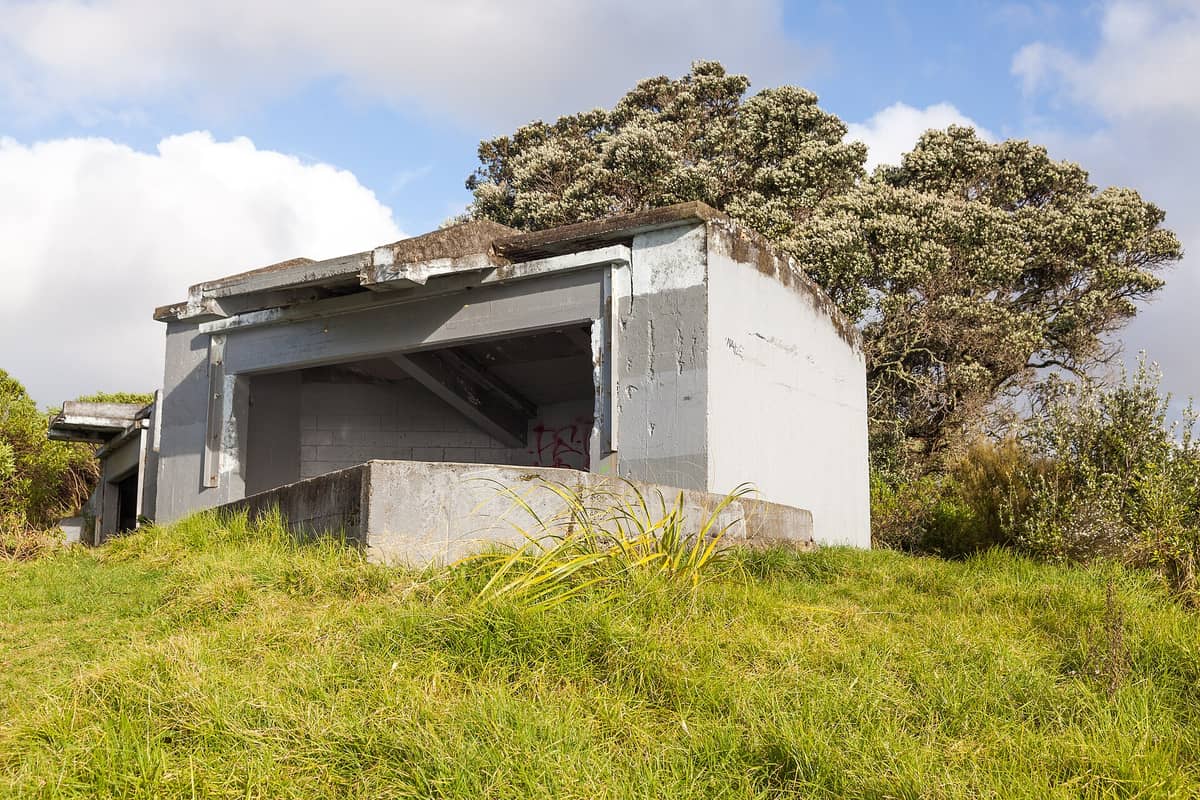
The headland also contains remnants of early twentieth-century military infrastructure, including gun emplacements installed as coastal defences. These sit quietly in the grass, easy to miss if you are focused on the water view. For broader context on Auckland's Māori heritage and how Tāmaki Makaurau was shaped by its mana whenua, the Auckland Māori culture guide is worth reading before or after your visit.
Tickets & tours
Live prices and dates from our booking partner. If you book, we may earn a commission at no extra cost to you.
Luggage Storage in Auckland
From 5 €Instant confirmationFree cancellationNew Zealand West Coast discovery tour
From 100 €Instant confirmationFree cancellation13,000ft skydiving experience in Auckland
From 195 €Instant confirmationFree cancellationDiscover Auckland City Tour
From 88 €Instant confirmationFree cancellation
The Experience: What You See, Hear, and Feel
Walking up from Tāmaki Drive, the incline is gentle enough for most fitness levels, though it is sustained rather than flat. The grass is kept short and open. There are no formal garden beds or manicured hedges. The simplicity is the point: your eye is drawn directly to the water and the sky.
At the top, the Michael Joseph Savage Memorial dominates the northern edge of the headland. Savage was New Zealand's first Labour Prime Minister, and his tomb here is a bold neoclassical structure surrounded by formal gardens maintained by the Labour Party. The juxtaposition of a prime ministerial memorial with a Māori land-rights battleground is one of Auckland's more quietly confrontational spatial arrangements. The gardens around the memorial are meticulously kept, with rose beds and low hedges that create a formal contrast to the open hillside.
From the lawn below the memorial, the harbour view stretches in a wide arc. Rangitoto Island sits directly to the northeast, its symmetrical volcanic profile an unmistakable reference point. The water changes colour dramatically depending on time of day and cloud cover, moving between a flat grey-green in overcast conditions and a deep blue with visible current lines on clear afternoons.
Wind is a consistent presence on the headland. On days when Auckland's forecast suggests mild conditions, Bastion Point can feel considerably more exposed. Bring a layer regardless of the season. If you plan to walk here as part of a longer coastal route, the Tāmaki Drive waterfront connects westward toward the city and Mission Bay to the east. Mission Bay Beach is a short walk or cycle along the waterfront and a natural extension to the visit.
How the Experience Changes by Time of Day
Early morning is the calmest window. Between 7 and 9 am, you are likely to share the headland with joggers completing the Tāmaki Drive coastal loop and dog walkers from the Ōrākei neighbourhood. The light at this hour is low and directional, catching the harbour surface and making Rangitoto Island appear to float. The city noise is minimal and the wind is usually at its lightest.
Midday on weekends brings the largest visitor numbers, particularly in summer. Families spread picnic blankets across the main lawn, and the car park on Hapimana Street fills steadily. The view remains excellent, but solitude is harder to find. Weekday midday visits are noticeably quieter.
Late afternoon, roughly an hour before sunset, is the most photographically interesting window. The westward orientation of Auckland means the light shifts behind the city skyline, casting long shadows across the headland grass and turning the harbour into a surface of broken copper and silver. This is also when the wind often picks up. If you are visiting for photography, position yourself on the northern slope facing toward Rangitoto rather than looking back toward the city.
💡 Local tip
For the best harbour light, visit in the two hours before sunset on a clear day. Face northeast toward Rangitoto Island rather than looking back toward the Auckland Sky Tower, where the light will be behind the buildings.
Getting There and Getting Around
Bastion Point is accessible by public transport, on foot, or by car. Ōrākei Train Station on Auckland's Eastern Line is the most direct public transport option; from the station it is a short walk up through the Ōrākei neighbourhood to the headland. Buses running along Tāmaki Drive also stop within reasonable walking distance. Auckland Transport's journey planner at at.govt.nz is the reliable tool for current timetables and route confirmation.
Cyclists coming from the city can follow Tāmaki Drive eastward from the CBD waterfront, a flat and mostly separated route that takes roughly twenty to thirty minutes from the Britomart area. The Tāmaki Drive coastal route is a well-used path that connects Bastion Point to the downtown waterfront and continues east toward St Heliers.
There is a public car park at 15 Hapimana Street, Ōrākei. On busy weekend days this fills early; if driving, arrive before 10 am or after 3 pm. Street parking in the surrounding residential streets requires attention to local signage.
Practical Notes and Honest Limitations
Bastion Point does not have formal facilities beyond the parking area. Bastion Point has limited formal facilities; public toilets are available at the Michael Joseph Savage Memorial Gardens, but there are no cafés or visitor centre on the headland. The nearest food and coffee options are in Mission Bay to the east or along Tāmaki Drive toward the city. Plan accordingly, particularly if visiting with children.
The terrain involves a grassed incline that is not steep but is sustained. The official Auckland Council path description notes a gentle incline; however, specific wheelchair accessibility or paved accessible routes on the headland itself are not confirmed in official sources. If accessibility is a requirement, contact Auckland Council directly before visiting.
If your primary motivation is panoramic views of Auckland and the harbour, and you are happy to pay for a more vertiginous perspective, the Auckland Sky Tower offers a 360-degree cityscape at height. Bastion Point's view is horizontal and harbour-focused rather than aerial. They serve different purposes and suit different moods.
⚠️ What to skip
Auckland's weather changes quickly. The headland is fully exposed with no shelter. If rain is forecast, the view closes to near zero in low cloud, and the grass becomes slippery. Check the forecast and bring a waterproof layer regardless of season.
Who Will Get the Most From This Visit
Visitors with an interest in New Zealand history, and particularly in the Treaty of Waitangi and Māori land rights, will find Bastion Point deeply affecting. Reading about the 506-day occupation before arriving transforms what might otherwise feel like a pleasant hilltop park into something considerably more significant. The Auckland volcanic cones guide provides useful context for understanding the broader relationship between Auckland's landscape and its mana whenua, which adds another dimension to standing on Takaparawhau.
Photographers and walkers who have already done Mission Bay or the Tāmaki Drive waterfront will appreciate Bastion Point as an elevated counterpoint to the flat coastal path below. Families with older children who can handle the walk will find it rewarding, though families with very young children should note the absence of toilet facilities on the headland itself.
Travellers looking for a brief, high-value stop that does not require purchasing tickets, booking in advance, or joining a queue will find Bastion Point refreshingly uncomplicated. You walk up, you look out, you read the landscape. That simplicity is genuinely rare in a city.
Those who find grassed open spaces without structured interpretation boards or audio guides frustrating may feel under-served. The historical significance is not immediately legible from the landscape itself. There is no interpretive centre, no guided trail markers beyond basic Auckland Council signage. The depth of the experience depends almost entirely on what you bring to it.
Insider Tips
- Walk the full perimeter of the headland rather than stopping at the first viewpoint. The northern edge near the Savage Memorial offers a different angle on Rangitoto Island and the channel shipping lanes that the main lawn viewpoint misses.
- The Michael Joseph Savage Memorial gardens are a formal garden beside the public reserve. This is an unusual arrangement and a curious detail: a political party maintains a formal garden on public land with historical Māori significance.
- Combine Bastion Point with a walk east along Tāmaki Drive to Mission Bay for coffee and food, since the headland itself has no food or drink facilities. The walk between them takes around ten to fifteen minutes on a flat path.
- If you see Ōrākei Marae from the headland, understand that this is the home marae of Ngāti Whātua Ōrākei. It is not a visitor attraction and should be approached with appropriate respect unless you have been invited.
- On overcast days when the view is muted, the military gun emplacements in the grass become more interesting focal points. They are easy to overlook when the harbour is sparkling, but worth examining closely for what they reveal about early twentieth-century coastal defence planning.
Who Is Bastion Point (Takaparawhau) For?
- History and politics travellers who want to understand New Zealand's Treaty of Waitangi legacy in a tangible, on-the-ground setting
- Photographers seeking a horizontal harbour panorama with Rangitoto Island framing and soft late-afternoon light
- Walkers combining Bastion Point with the Tāmaki Drive coastal path as a half-day loop from the city
- Budget travellers who want a genuinely worthwhile Auckland experience without spending anything
- Anyone wanting a quiet, unstructured pause in a city that tends to direct visitors toward ticketed attractions
Nearby Attractions
Combine your visit with:
- Auckland Botanic Gardens
Spread across 64 hectares in Manurewa, the Auckland Botanic Gardens offer free entry every day of the year, with themed garden collections, 10 hectares of native forest, and a visitor centre on site. It sits south of the city centre and rewards a longer visit than most people initially plan for.
- Auckland Zoo
Auckland Zoo has been part of the city's fabric since 1922, sitting in the Western Springs precinct with a collection that spans native New Zealand wildlife and international species. This guide covers everything from ticket prices and transit options to the best time of day to arrive and which exhibits deliver the most.
- Bethells Beach (Te Henga)
Bethells Beach, officially Te Henga (Bethells Beach), is a raw, dramatic stretch of black-sand coastline about 45 minutes west of central Auckland. With rolling dunes, a freshwater lagoon, strong surf, and zero phone coverage, it delivers a genuine wilderness experience rare for a city of 1.6 million people.
- Coast to Coast Walkway
The Coast to Coast Walkway stretches 16 km across the Auckland isthmus, linking Waitematā Harbour in the north to Manukau Harbour in the south. Free to walk and open every day, this route passes volcanic cones, historic parks, and inner-city neighbourhoods that most visitors never see.
Planning a trip? Discover personalized activities with the Nomado app.