Tāmaki Drive: Auckland's Great Coastal Route
Tāmaki Drive stretches 8 kilometres along Auckland's eastern waterfront, connecting the city centre with Mission Bay, Kohimarama, and St Heliers. Whether you walk a section, cycle the full route, or simply pull over at a beach, it ranks among the most scenic and accessible experiences in the city.
Quick Facts
- Location
- Eastern waterfront, Auckland — from Ōkahu Bay to St Heliers
- Getting There
- TāmakiLink bus from Britomart; stops at Ōkahu Bay, Kelly Tarlton’s, Mission Bay, Kohimarama, St Heliers, and Glen Innes
- Time Needed
- 1 hour (drive-through) to a full day (walking or cycling the 8 km route)
- Cost
- Free (public road and coastal path); bus fare applies if using AT services
- Best for
- Cyclists, walkers, families, swimmers, sunset-seekers
- Official website
- www.aucklandnz.com/explore/tamaki-drive-coastal-path
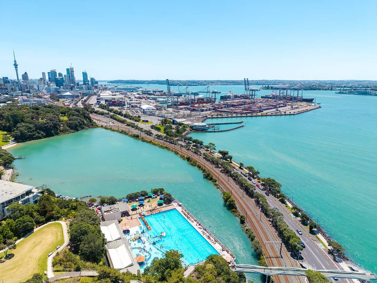
What Tāmaki Drive Actually Is
Tāmaki Drive is a public road and coastal route running approximately 8 kilometres along Auckland's eastern harbourside, completed in 1932. It links the inner suburb of Ōrākei with the beachside communities of Mission Bay, Kohimarama, and St Heliers. For most of its length the road runs right beside the water, with a shared pedestrian and cycling path on the seaward side and a parade of pohutukawa trees whose red blossoms turn the route vivid in December and January.
This is not a manicured attraction with entrance gates. It is a working road that also happens to be one of the city's most used recreational corridors. On any given weekend morning you will find joggers, families with prams, cyclists in lycra, people eating fish and chips on a sea wall, and teenagers heading to the beach. The atmosphere is relaxed and genuinely local in a way that some central-city attractions are not.
💡 Local tip
The TāmakiLink bus runs from Britomart along Tāmaki Drive and continues to Glen Innes, with stops at Ōkahu Bay, Kelly Tarlton's, Mission Bay, Kohimarama, and St Heliers. It is the easiest car-free option and lets you walk back along the coast at your own pace.
The Route: What You Pass and In What Order
Starting from the city end, the first landmark is Kelly Tarlton's Sea Life Aquarium at Ōkahu Bay, built into old sewage tanks beneath the road. From there the path hugs the shoreline past Ōkahu Bay itself, a sheltered cove that is calmer and less visited than Mission Bay further along. The water here is clear enough on a still day that you can see the sandy bottom from the path.
Mission Bay is the midpoint and the social centre of the route. The grassed foreshore, fountain, and row of ice cream shops and cafes make it the most popular stop, particularly on summer afternoons when the beach fills and parking becomes competitive. If you are cycling or walking and do not want to stop in a crowd, the path continues clearly past Mission Bay toward Kohimarama, which has its own quieter beach and yacht club. Beyond Kohimarama, the route continues to St Heliers, a suburb with a village feel and good places to eat. The Kelly Tarlton's Sea Life Aquarium at the western end of the drive makes a sensible add-on, particularly for families.
The full 8 km from the city-end turnoff to St Heliers takes roughly 1.5 to 2 hours on foot at a comfortable walking pace, not counting stops. Cyclists can cover it in 30 to 40 minutes. Because it is linear rather than circular, most people either walk one way and bus back, or drive to one end, walk to the other, and return the same way.
Tickets & tours
Live prices and dates from our booking partner. If you book, we may earn a commission at no extra cost to you.
Luggage Storage in Auckland
From 5 €Instant confirmationFree cancellationNew Zealand West Coast discovery tour
From 100 €Instant confirmationFree cancellation13,000ft skydiving experience in Auckland
From 195 €Instant confirmationFree cancellationDiscover Auckland City Tour
From 88 €Instant confirmationFree cancellation
How It Changes Through the Day
Early mornings, roughly 6 to 8 am, are when the route is at its most atmospheric. The light off the Waitemata Harbour at that hour is low and soft, the path is quiet, and you can hear water lapping against the sea wall. Serious cyclists have usually done a lap by then; the slower crowds have not arrived yet. If the sky is clear, Rangitoto Island sits directly across the harbour looking exactly as a dormant volcano should: perfectly symmetrical and slightly imposing.
By mid-morning on weekends, Mission Bay fills rapidly. From roughly 11 am onward, the foreshore is busy and parking along Tāmaki Drive becomes scarce. If you are driving, arrive before 10 am or accept that you will need to park and walk from further back. Summer weekends (December through February) push this earlier still. Mission Bay Beach specifically gets very crowded on hot Saturdays; Kohimarama beach, a 10-minute walk further along the path, is noticeably quieter and worth the extra effort if you want to actually spread out on the sand.
Sunset is the third distinct window for visiting. The western-facing sections of the drive, particularly around Ōkahu Bay, catch the last light over the city skyline and harbour. In summer this can mean golden-hour light at around 8 pm. Bring something warm regardless of how the day felt: the harbour breeze stiffens noticeably in the evening.
Swimming, Cycling, and What the Water Is Like
Several beaches along Tāmaki Drive are designated for swimming. Mission Bay and Kohimarama both have generally good water quality, though conditions vary and Auckland Council posts water quality notices at beach entrances following heavy rain. After significant rainfall, a 48-to-72-hour wait is typically advisable before swimming at any urban beach in Auckland.
⚠️ What to skip
Water quality at Mission Bay and other Tāmaki Drive beaches can temporarily decline after heavy rain due to stormwater runoff. Check Auckland Council's Safeswim website for current alerts before entering the water.
A shared cycling and walking path runs along much of the route, separated from traffic in sections. It is wide enough that faster cyclists and pedestrians can generally pass without conflict, but on busy summer days it requires attention. Cycle hire is available from providers in the central city; check availability and current operators through Auckland Transport's website before relying on any specific provider. It is wide enough that faster cyclists and pedestrians can generally pass without conflict, but on busy summer days it requires attention. Cycle hire is available from providers in the central city; check availability and current operators through Auckland Transport's website before relying on any specific provider.
The path surface is paved and largely flat, with a few gentle rises. AucklandNZ describes the coastal path as accessible to all, though Auckland Transport notes that some bus stop access points along the route are subject to ongoing footpath improvement works. If mobility is a consideration, checking conditions at specific sections before visiting is worthwhile.
Historical and Cultural Context
The coastline that Tāmaki Drive now follows has been significant to Māori for centuries. The name Tāmaki appears in the wider name for Auckland itself: Tāmaki Makaurau, often translated as 'Tāmaki desired by many,' a reference to the area's fertility and strategic position. The road itself was constructed and opened in 1932, part of the broader development of Auckland's eastern suburbs during that era. For a deeper sense of how Māori history is woven into Auckland's landscape, the Auckland Māori culture guide provides useful context before any visit to the area.
The pohutukawa trees lining much of the route are significant beyond aesthetics. Known as the New Zealand Christmas tree for their timing, they are a species native to the northern North Island coastline and were historically used by Māori for medicinal purposes. Many of the specimens along Tāmaki Drive are large and old, their roots working into the sea wall. When they are in full bloom, the contrast between the red flowers and the blue harbour water is striking in a way that photographs rarely capture accurately.
Getting There and Practical Details
The most practical car-free option is the TāmakiLink bus, which departs from Britomart in the Britomart transport hub and runs the length of the route with stops at Ōkahu Bay, Kelly Tarlton's, Mission Bay, Kohimarama, and St Heliers. Auckland Transport operates the service; check current timetables and fares on the AT website or app before travel, as schedules are subject to change. Payment is by AT HOP card or contactless debit and credit card.
Driving is feasible outside peak hours. There is free on-street parking along parts of the route, but it fills quickly on weekend mornings and throughout summer. Arriving before 9:30 am is a reliable strategy if you want a spot near Mission Bay without circling. The road itself is straightforward: from the CBD, follow Quay Street east, which transitions into Tamaki Drive.
Tāmaki Drive connects naturally with several other Auckland experiences worth combining into a half-day or full-day itinerary. Bastion Point sits just inland from Ōkahu Bay and offers elevated views over the harbour and a significant piece of Auckland's social and political history. The best viewpoints in Auckland guide covers this and other harbour-facing vantages worth pairing with a walk along the drive.
Photography Along the Route
The single most photogenic element of Tāmaki Drive is the view of Rangitoto Island across the harbour, best captured from the Ōkahu Bay end in the morning when the light comes from behind you. The island's symmetrical silhouette and the harbour's shifting colour from grey-green to deep blue depending on cloud cover make it genuinely difficult to take a bad photograph here.
For the pohutukawa in bloom, mid-December to early January is the window. The trees are most reliably photogenic from the walking path looking upward, or from the water if you have access to a kayak or paddleboard. The Mission Bay fountain and beach scene works better in late afternoon when the light warms the sand.
ℹ️ Good to know
Rangitoto Island is visible from almost the entire length of Tāmaki Drive. The clearest views are from Ōkahu Bay. Overcast days can produce dramatic light across the harbour, so do not assume a cloudy day is a wasted one photographically.
Insider Tips
- Walk from St Heliers back toward the city rather than the other way: the Rangitoto views are more directly in front of you the whole way, and you end up at Ōkahu Bay in time for late-afternoon light.
- Kohimarama beach is noticeably quieter than Mission Bay on summer weekends and sits only 10 minutes further along the path. If swimming is the priority, it is worth the extra distance.
- The pohutukawa trees bloom from mid-December into January. If you are visiting during that window, the route looks significantly different from any other time of year and the combination of red flowers and blue harbour is worth timing your visit around.
- Combine Tāmaki Drive with Bastion Point: the Ōkahu Bay end of the drive is a short walk from the reserve, which offers elevated harbour views and historical significance most visitors to Mission Bay never bother with.
- Evening visits are underrated. Summer sunset from the Ōkahu Bay end, looking back toward the city, can be excellent. Bring a layer: the harbour breeze intensifies after the sun drops.
Who Is Tāmaki Drive For?
- Cyclists wanting a flat, scenic coastal route with clear start and end points
- Families looking for a free day out combining walking, swimming, and ice cream
- Visitors who want a genuinely local Auckland experience rather than a ticketed attraction
- Photographers chasing the Rangitoto Island harbour shot or pohutukawa season colour
- Anyone who wants to swim at an urban beach within easy reach of the city centre
Nearby Attractions
Combine your visit with:
- Auckland Botanic Gardens
Spread across 64 hectares in Manurewa, the Auckland Botanic Gardens offer free entry every day of the year, with themed garden collections, 10 hectares of native forest, and a visitor centre on site. It sits south of the city centre and rewards a longer visit than most people initially plan for.
- Auckland Zoo
Auckland Zoo has been part of the city's fabric since 1922, sitting in the Western Springs precinct with a collection that spans native New Zealand wildlife and international species. This guide covers everything from ticket prices and transit options to the best time of day to arrive and which exhibits deliver the most.
- Bastion Point (Takaparawhau)
Takaparawhau, known widely as Bastion Point, is a grassy headland in Ōrākei where Māori history, colonial conflict, and sweeping Waitematā Harbour views converge. It costs nothing to visit, carries centuries of significance, and rewards visitors who take time to understand what they are standing on.
- Bethells Beach (Te Henga)
Bethells Beach, officially Te Henga (Bethells Beach), is a raw, dramatic stretch of black-sand coastline about 45 minutes west of central Auckland. With rolling dunes, a freshwater lagoon, strong surf, and zero phone coverage, it delivers a genuine wilderness experience rare for a city of 1.6 million people.
Planning a trip? Discover personalized activities with the Nomado app.