Bến Nghé Canal & Riverside Walk: Saigon's Living Waterway
The Bến Nghé Canal cuts through the heart of District 1 as one of Ho Chi Minh City's oldest urban waterways, linking the Saigon River to the city's colonial core. Free to walk any hour of the day, the riverside path offers a grounded, unhurried perspective on a city that rarely slows down.
Quick Facts
- Location
- District 1, Ho Chi Minh City (along Ton Duc Thang Street & Ben Van Don Street)
- Getting There
- 15 min walk from Ben Thanh Market; grab or xe om to Mong Bridge or Ton Duc Thang Street
- Time Needed
- 45 minutes to 1.5 hours for a leisurely walk
- Cost
- Free
- Best for
- Early morning walkers, history lovers, photographers, and anyone wanting a break from the tourist circuit
What Is the Bến Nghé Canal?
The Bến Nghé Canal, officially known in Vietnamese as Kênh Bến Nghé or Rạch Bến Nghé, is a tributary of the Saigon River that traces the southern edge of District 1. It is not a manicured tourist attraction with ticket booths and audio guides. It is a working waterway in an active city, and that is precisely what makes it worth your time.
The canal's name comes from the Bến Nghé area, a settlement of some 40 villages that developed along this stretch of river during the 17th century. French colonial administrators, who later controlled the city, referred to it as the arroyo Chinois, or "Chinese channel," reflecting the significant Chinese merchant communities who traded along its banks. That layered history, Vietnamese, Chinese, and French, is still legible in the architecture and street names surrounding the water today.
The canal runs between Ton Duc Thang Street on the District 1 side and Ben Van Don Street in District 4, connected by the pedestrian-accessible Mong Bridge. On one side you have the grand colonial facades of central Saigon; on the other, the Saigon River broadens out toward the horizon. Walking the canal is essentially walking the seam between two different cities.
How It Feels to Walk Here
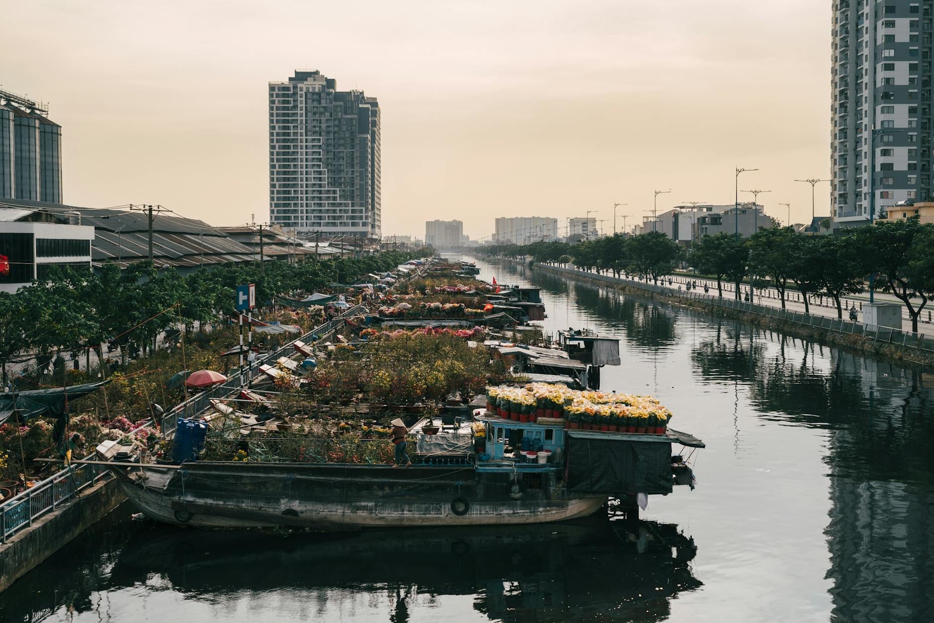
The canal walk does not announce itself. There are no signs directing you here from the main tourist drag, and that low profile is part of the appeal. Ton Duc Thang Street runs parallel to the water on the District 1 side, shaded intermittently by large tropical trees whose roots have had decades to buckle the pavement. The smell changes as you walk: diesel from passing boats, then something organic and brackish from the water, then the warm sweetness of banh mi from a cart around the corner.
The water itself is a deep olive-brown, the color of strong tea left too long in the cup. Flat-bottomed cargo boats move slowly through it at most hours, low in the water and loaded with construction materials or agricultural goods. Watching one pass is a reminder that this canal still functions as genuine infrastructure, not a scenic backdrop repurposed for tourism.
💡 Local tip
For the cleanest light and the fewest motorbikes, arrive between 6:00 and 7:30 AM. Local residents use this window for exercise, and the low sun catches the water at a sharp angle that photographers will appreciate.
By mid-morning the street vendors appear in force along the pavements near Mong Bridge. Midday heat is serious in this city, and the canal walk becomes uncomfortable without shade between roughly 11:00 AM and 3:00 PM. If you visit during those hours, stick to the tree-lined stretches and plan a break at one of the small cafes facing the water.
Tickets & tours
Hand-picked options from our booking partner. Prices are indicative; availability and final rates are confirmed when you complete your booking.
Private full-day trip from Ho Chi Minh City to Mekong Delta
From 52 €Instant confirmationFree cancellationLandmarks of Ho Chi Minh City half-day tour
From 33 €Instant confirmationFree cancellationCu Chi tunnels guided experience from Ho Chi Minh City
From 33 €Instant confirmationFree cancellationHalf-day Cu Chi Tunnels guided tour from Ho Chi Minh City
From 21 €Instant confirmationFree cancellation
Historical and Cultural Context
The Bến Nghé area was the original commercial heart of what would become Saigon. Long before French gunboats appeared in the 1850s, this canal served as the primary conduit for goods moving between the Mekong Delta rice fields and the South China Sea trade routes. The name "Bến Nghé" is often translated as "Buffalo Wharf," a reference to the livestock trade that once characterized the landing.
French colonial planners later used the canal as a geographic boundary when they redesigned the city grid. The grand boulevard now called Ton Duc Thang Street was laid out to connect the colonial administrative core to the riverfront, and the canal formed the southern limit of that formal urban plan. You can trace this logic on foot: north of the canal, the streets are wide, right-angled, and lined with buildings that still carry French proportions. South of it, the grain of the city becomes finer and more irregular.
This context makes the canal walk a useful complement to the more formal colonial landmarks nearby. After visiting the Central Post Office or the People's Committee Building, a walk along the water puts those buildings in geographical perspective.
Time of Day: How the Canal Changes
Early Morning (6:00–8:30 AM)
This is the canal at its most local. Older residents do their morning stretches on the wider pavement sections. A few fishermen sit with lines in the water, seemingly unconcerned with results. The light is soft and directional, ideal for photography, and the traffic on Ton Duc Thang Street has not yet reached its full volume. Street food carts selling bao and black coffee appear at the foot of Mong Bridge around 6:30 AM most mornings.
Late Afternoon and Sunset (4:30–6:30 PM)
As the temperature drops slightly, the canal walk becomes social. Couples sit on the low walls near the bridge. Children ride bicycles on the wider pavement near Ton Duc Thang. The Bitexco Financial Tower catches the last sunlight to the northeast, and the sky above the Saigon River turns shades of copper and grey. This is the most photogenic hour for wide shots that include both the water and the skyline.
From this vantage point you can see the upper floors of Bitexco Financial Tower rising above the surrounding mid-rise blocks, which helps orient you within the wider District 1 layout.
After Dark (7:00 PM onward)
The canal is open around the clock, but the stretches away from Mong Bridge become poorly lit after dark and are not particularly comfortable to walk alone. The bridge itself is well-lit and remains lively, with food vendors and the ambient noise from boat traffic and the elevated road nearby. Night walkers will get more from the lit promenades along Nguyen Hue or the Saigon River waterfront than from the canal in darkness.
Practical Walkthrough: How to Approach the Canal
Most visitors arrive from central District 1, walking south down Ton Duc Thang Street from near the Saigon Opera House or from the waterfront park beside the Saigon River. The walk from Ben Thanh Market takes around 15 minutes on foot through streets that already reward close attention.
Mong Bridge is the natural focal point. It is wide enough to cross comfortably on foot and gives the best view up and down the canal in both directions. From the bridge, you can continue south into District 4, which has its own character: narrower lanes, fewer tourists, and local lunch spots that charge a fraction of District 1 prices.
ℹ️ Good to know
District 4, directly across Mong Bridge, is one of the least-visited neighborhoods adjacent to the tourist center. A 20-minute wander south of the bridge will take you through genuine local market streets without requiring any transport.
Wear lightweight, breathable clothing and footwear with grip, as some pavement sections near the water's edge are uneven. Sunscreen is non-negotiable between 9:00 AM and 4:00 PM. The canal walk is largely flat, though the pavement surface varies considerably, and sections near the water have low barriers rather than high railings. Travelers with mobility limitations should note that accessible infrastructure along the canal itself is minimal.
⚠️ What to skip
Do not lean on or sit on the low concrete walls directly at the canal edge. They are not engineered as seating, and the drop to the water below is unguarded in many sections.
Photography Notes
The canal rewards patient photographers more than casual snapshots. The best compositions involve the contrast between the slow-moving boats on the olive water, the colonial-era facades visible on the northern bank, and the contemporary skyline rising behind them. A wide-angle lens captures this layering well from the midpoint of Mong Bridge.
Morning reflections on the water are clearer before boat traffic picks up around 8:00 AM. In the late afternoon, the light comes from the west, which means standing on the District 4 side of the bridge gives you a better angle on the lit facades of the District 1 bank. Drone photography is restricted in central Ho Chi Minh City without permits; check current regulations before flying.
Who This Walk Is Not For
If your priority is curated sights with clear explanations, the canal walk will feel unstructured. There are no interpretation panels, no guided paths, and the canal itself is not visually pristine. The water is murky and carries some urban odor, particularly on warmer days or at low tide. Travelers expecting a polished riverside promenade similar to those in Singapore or Bangkok will find this rougher and less manicured.
Families with very young children should note the low or absent barriers near the water's edge along some stretches. For a more structured outdoor experience in central Saigon, the Nguyen Hue Walking Street or Saigon Zoo and Botanical Garden are better alternatives.
Insider Tips
- Cross Mong Bridge into District 4 for lunch. The com tam (broken rice) shops on the streets immediately south of the bridge serve the same dish you'd pay double for in District 1, with zero tourist markup.
- The best single viewpoint is the center of Mong Bridge at 6:15 AM on a clear morning: the low sun backlights the cargo boats and throws long reflections across the olive water. Give yourself 20 minutes there before the light shifts.
- If you follow Ton Duc Thang Street north from the canal, it leads directly to the Saigon River waterfront park, making a natural circuit: canal south, river north, with the colonial quarter in between.
- Street coffee vendors near the bridge foot (District 1 side) typically set up by 6:30 AM. A ca phe sua da from a cart here, rather than a cafe, costs around 15,000–20,000 VND and tastes identical.
- Avoid the canal walk entirely between noon and 3:00 PM from March through May. The combination of direct sun, radiant heat from the pavement, and minimal shade on exposed sections makes it genuinely unpleasant.
Who Is Bến Nghé Canal & Riverside Walk For?
- Early risers who want to see how the city operates before the tourist day begins
- History and urban geography enthusiasts tracing the French colonial layout of Saigon
- Photographers looking for layered compositions of old waterways against a modern skyline
- Walkers linking multiple District 1 landmarks into a single self-guided half-day route
- Travelers who find overly managed attractions stifling and prefer unscripted urban exploration
Nearby Attractions
Other things to see while in District 1 (Colonial Quarter):
- Bến Thành Market
Bến Thành Market has anchored the heart of Saigon since 1912 and remains one of Ho Chi Minh City's most recognizable landmarks. With nearly 1,500 booths spread across 13,000 square meters, it sells everything from fresh produce and dried seafood to ao dai fabric, lacquerware, and street food. This guide covers the realities of visiting, including when it is worth your time and when it is not.
- Bitexco Financial Tower & Saigon Skydeck
The Bitexco Financial Tower is District 1's most recognizable skyscraper, its lotus-inspired silhouette rising 262 meters above the Saigon River. The Saigon Skydeck on the 49th floor offers a glass-enclosed, 360-degree panorama that takes in the whole city at once, from colonial rooftops to the river bends to the sprawling suburbs beyond.
- Saigon Central Post Office
Built between 1886 and 1891 and attributed to Gustave Eiffel's engineering office, the Saigon Central Post Office is one of the finest French colonial buildings in Southeast Asia. It functions as a working post office to this day, meaning you can mail a postcard home from inside a genuine architectural landmark. Free to enter and centrally located in District 1, it earns its place on most itineraries.
- Đồng Khởi Street
Once the elegant Rue Catinat of French colonial Saigon, Đường Đồng Khởi runs 630 meters through the heart of District 1, running from Nguyễn Du Street (across from Notre Dame Cathedral) to the Saigon River waterfront at Bạch Đằng Quay. Today it is a compact corridor of colonial facades, high-end boutiques, art galleries, and landmark buildings that together form a living archive of the city's layered history.