Saigon River (Sông Sài Gòn): Ho Chi Minh City's Living Waterway
The Saigon River stretches 251 kilometres from the Cambodia border to the South China Sea, forming the city's eastern boundary and shaping its identity for centuries. Whether you watch the skyline from a slow dinner cruise or walk the waterfront promenade at dusk, the river offers a perspective on Ho Chi Minh City that no street-level tour can replicate.
Quick Facts
- Location
- Eastern edge of Ho Chi Minh City; Bình Thạnh District shoreline
- Getting There
- Bach Dang Wharf, District 1 (taxi/ride-hail from central hotels in 5–10 min)
- Time Needed
- 1–2 hours for a waterfront walk; 2–3 hours for an evening cruise
- Cost
- Free to walk the promenade; river cruises vary by operator
- Best for
- Skyline photography, evening outings, historical context, escaping the city heat
What the Saigon River Actually Is
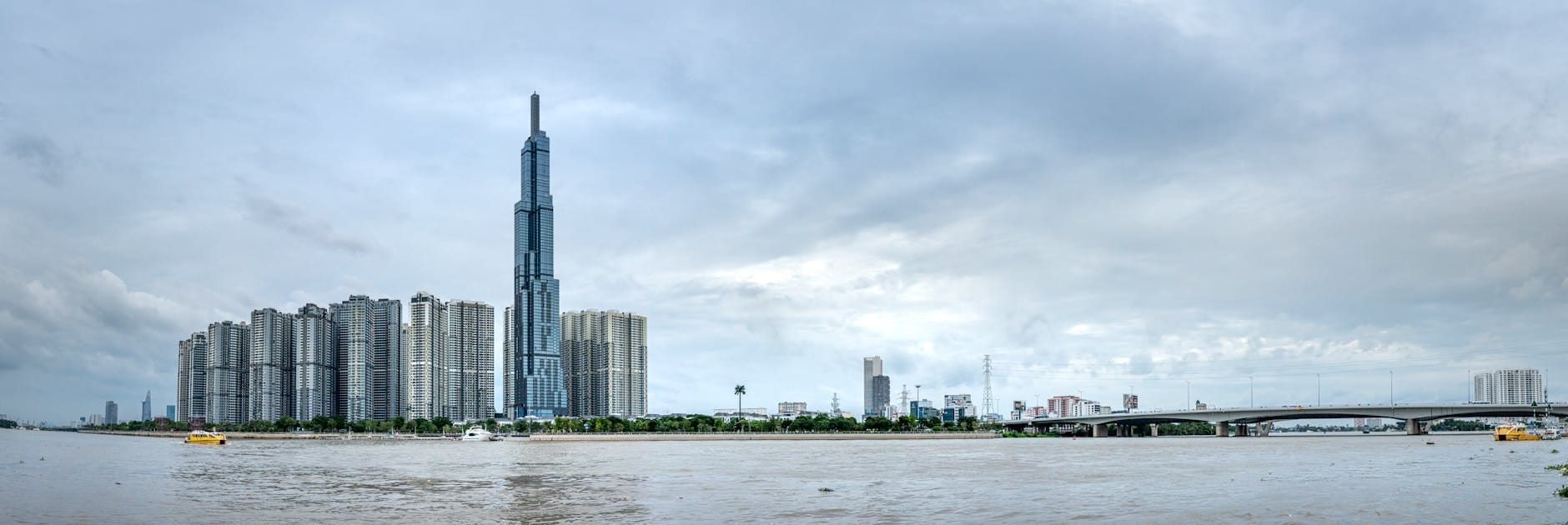
The Saigon River (Sông Sài Gòn) is not a city attraction in the conventional sense. There are no gates, no ticket counters, no opening hours. It is a 251-kilometre working waterway that originates near Phum Daung in southeastern Cambodia, flows south-southeast through the Vietnamese lowlands, hugs the eastern flank of Ho Chi Minh City, and eventually merges with the Đồng Nai River before reaching the South China Sea. The river has been the city's commercial spine since the 17th century, and its western bank, from Saigon Port up through Bình Thạnh District, is where the city's relationship with the water is most legible.
For a traveller, engaging with the river means choosing your vantage point: the waterfront promenade along Bach Dang in District 1, a dinner or sunset cruise departing from that same wharf, a visit to the Bình Quới Tourist Village on the Thanh Đa peninsula in Bình Thạnh District, or simply crossing via one of the modern bridges to catch the skyline from the opposite bank. Each approach gives you a different city.
💡 Local tip
For the clearest views and coolest temperatures, arrive at the riverfront between 5:30 and 7:00 PM. The heat has dropped, the light turns golden over the water, and the Bitexco Financial Tower and Landmark 81 are both visible against the sky.
The River Through History
The Saigon River's strategic value explains why a city grew here at all. French colonial administrators recognized the deep-water access that allowed oceangoing vessels to dock far inland, and Saigon Port became one of the most significant ports in Southeast Asia by the late 19th century. The waterfront warehouses, customs buildings, and wide riverside boulevards that the French laid out still influence the urban fabric of District 1 today.
Two engineering additions reshaped the modern river. The Dầu Tiếng Dam, completed in 1985, altered the upper river's flow for irrigation, reducing the seasonal variation that once defined life along the banks. Then in 2011, the Saigon River Tunnel opened beneath the water, connecting District 1 to the Thủ Thiêm development zone on the eastern bank. It remains one of the longest cross-river road tunnels in Southeast Asia and dramatically accelerated development on the east side, which had been farmland and wetland within living memory.
The skyline visible from the river today, anchored by Landmark 81 to the north and the Bitexco Financial Tower Skydeck in the centre, is almost entirely a product of the post-2000 construction boom. Seeing it from the water compresses four decades of change into a single panorama.
Tickets & tours
Hand-picked options from our booking partner. Prices are indicative; availability and final rates are confirmed when you complete your booking.
Ho Chi Minh Saigon River Dinner Cruise with Live Music
From 81 €Instant confirmationFree cancellationCar hire with driver in Cu Chi from Ho Chi Minh city half-day
From 89 €Instant confirmationFree cancellationSaigon countryside guided bike tour with lunch
From 107 €Instant confirmationFull-day car hire with driver from Ho Chi Minh City to Can Tho
From 175 €Instant confirmationFree cancellation
The Waterfront Promenade: What to Expect on Foot
The most accessible entry point is the Bach Dang Wharf area in District 1, where a paved riverside walkway runs alongside a row of moored river cruise vessels. Early mornings here are genuinely calm: older residents do tai chi on the concrete, fishing lines hang into the brown water, and the opposite bank is still swallowed in haze. The smell is brackish with a faint diesel edge from the working boats.
By midday the sun is aggressive, the walkway offers almost no shade, and the heat reflected off the pavement makes extended walking unpleasant. This is not a waterfront designed for lingering in the middle of the day. Come back at 5 PM and the scene has completely shifted: motorbikes line the railings, couples sit on the low walls, street food sellers set up near the wharf entrance, and the light on the water shifts from white to amber to deep orange over the course of an hour.
⚠️ What to skip
The promenade has limited seating and almost no shade. Bring water, wear light clothing, and avoid the 11 AM to 3 PM window unless temperatures are unusually mild.
River Cruises: What the Experience Is Like
Cruises depart from Bach Dang Wharf and range from simple daytime sightseeing boats to dinner cruises with live music, running roughly two hours. The dinner cruise format is the most popular among visitors, and for practical reasons: the river at night, with the city lights reflected in the water and the bridges lit overhead, is considerably more dramatic than the daytime view, when the industrial character of the far bank is in full evidence.
On a typical cruise heading north, the western bank reveals the transition from the colonial-era downtown to the newer residential towers of Bình Thạnh District, while the eastern bank shows the Thủ Thiêm development zone still mid-construction. The Thu Thiem Bridge, Ba Son Bridge, and Phu My Bridge all come into view depending on the route. The boat traffic itself, container vessels, water taxis, and the occasional traditional wooden craft, adds a layer of activity that makes the river feel genuinely alive rather than purely scenic.
Operators and prices change frequently, so verify current options locally at Bach Dang Wharf or through your hotel. Be aware that budget cruise boats can be very loud inside due to music systems, making conversation difficult. If a quieter experience matters to you, ask before boarding.
Bình Thạnh and the Thanh Đa Peninsula
The Thanh Đa peninsula in Bình Thạnh District is where the Saigon River loops dramatically, almost encircling a narrow finger of land that feels removed from the city despite being only a few kilometres from downtown. The Bình Quới Tourist Village sits on this peninsula, offering gardens, outdoor dining, and a slower pace. It attracts primarily Vietnamese families and is rarely crowded with foreign tourists, which is part of its appeal.
Getting to Thanh Đa from central Ho Chi Minh City takes about 20 minutes by ride-hailing app, crossing the bridge over the river channel that separates the peninsula. The road narrows considerably once you are on the peninsula itself, and motorbikes become the practical mode of movement. The water is visible on both sides at points, and on a quiet weekday morning the area has an almost rural texture: birds, tall trees, and the low sound of river traffic in the distance.
Practical Details for Getting There and Moving Around
The Bach Dang Wharf area is roughly 10 to 15 minutes by taxi or ride-hailing app from the major tourist hotels in District 1. Metro Line 1 (Ben Thanh–Suoi Tien), which opened in late 2024, has a terminus at Ben Thanh Station within walking distance of the waterfront. Buses also serve the area but routes and stop locations are complex for first-time visitors; ride-hailing remains the most practical option.
The Saigon River Tunnel connects District 1 to the Thủ Thiêm area on the eastern bank and is used primarily by private vehicles and motorbikes. Crossing by bridge is a viable option for those on motorbikes who want to photograph the skyline from the eastern bank, where the full width of the waterfront and central skyline is visible without obstruction.
For a broader sense of what to do in the city during your visit, the things to do in Ho Chi Minh City guide covers how the river fits into a full itinerary. If you are planning a longer stay, pairing a river evening with a day along Nguyen Hue Walking Street makes good geographic sense, as both are walkable from the same area of District 1.
Photography and the River
The best skyline photographs from the waterfront happen in the 20 minutes after sunset, when there is still soft blue light in the sky but the building lights are fully on. This window is short; arrive at least 40 minutes before sunset to get positioned. A wide-angle lens or a standard smartphone camera handles the view adequately, but the dynamic range between sky and water can be challenging at midday.
From a cruise boat, photography is easier in some ways and harder in others: you get unobstructed angles on the bridges and skyline, but the boat vibration and movement require faster shutter speeds. Night photography from the water can produce striking results but requires a steady hand or image stabilization. The bridges, particularly Thu Thiem Bridge with its cable-stay structure, are photogenic subjects in their own right.
ℹ️ Good to know
The river's water is brown rather than blue or green year-round, carrying sediment from the upper catchment. Photographs that show the water as a mirror of the sky are typically taken in low light conditions when the colour of the water is less visible.
Honest Assessment: Who Will Get the Most Out of This
The Saigon River rewards travellers who are comfortable making their own experience rather than following a set route. It is not a landmark with a clear arrival and departure point. If you are looking for something to tick off a list, the evening cruise is probably the right format: it gives you a fixed duration, a defined perspective, and a concrete reason to be on the water. If you have more time and curiosity, the combination of the waterfront promenade at dusk and a morning visit to Thanh Đa provides a genuinely textured picture of how the river functions as a living part of the city.
Travellers with only two or three days in the city may find the river best experienced as context rather than destination: visible from the rooftop of a riverside bar, in the background as you walk toward the Central Post Office, or from the window of a Grab crossing one of the bridges. The river is always there; the question is how much time you want to give it directly.
Those who should probably not prioritise the river as a standalone activity: travellers on very short itineraries focused on museums and markets, anyone with limited mobility who would find the unshaded promenade uncomfortable, and visitors who find industrial waterscapes less interesting than historic interiors. The Saigon River does not offer the polish of a purpose-built tourist waterfront; its appeal is partly its working character, and not everyone finds that appealing.
Insider Tips
- The eastern bank in Thủ Thiêm offers the best unobstructed views of the District 1 skyline. Cross via the tunnel or Thu Thiem Bridge by motorbike and find a spot along the undeveloped waterfront on the east side for a perspective most visitors never see.
- If you are booking a dinner cruise, ask specifically whether the route goes north toward Bình Thạnh or south toward Nhà Rồng Harbour. The northern route shows more residential riverbank and the peninsula landscape; the southern route takes you past the historic port area and older industrial infrastructure.
- Weekday mornings between 6:00 and 8:00 AM are the quietest time on the Bach Dang promenade. The light is soft, the cargo boats are active, and the absence of tourist crowds makes the working character of the river more visible.
- The Thanh Đa peninsula in Bình Thạnh is the easiest place to eat a meal beside the river in a garden setting, without the noise and pricing of tourist-oriented cruise restaurants. Bình Quới Tourist Village is the main venue, but smaller local restaurants on the peninsula road also have river views.
- Photographs of the river from ground level tend to show the railing, the pavement, and a narrow strip of water. For a more expansive view, position yourself at one of the bridge pedestrian lanes, where the full width of the river and the city on both sides are visible simultaneously.
Who Is Saigon River For?
- Evening walkers who want to experience the city's scale from outside its streets
- Photographers targeting skyline and bridge shots at golden hour or at night
- Travellers interested in the urban development story of post-reform Vietnam
- Families or couples looking for a relaxed dinner-cruise format away from street noise
- Curious visitors who want to understand why the city exists where it does
Nearby Attractions
Other things to see while in Bình Thạnh & the Saigon River:
- Landmark 81
Standing 461.2 meters above Ho Chi Minh City, Landmark 81 is the tallest building in Vietnam and the focal point of the Vinhomes Central Park development in Binh Thanh District. The Sky View Observatory on floors 79 to 81 delivers sweeping views across the Saigon River, the city grid, and far beyond — on a clear day, the horizon stretches toward the Mekong Delta lowlands. Below the observation deck, a full-scale shopping mall, cinema, and ice rink make this more than a single-purpose attraction.