Yarra River (Birrarung): Melbourne's Living Waterway
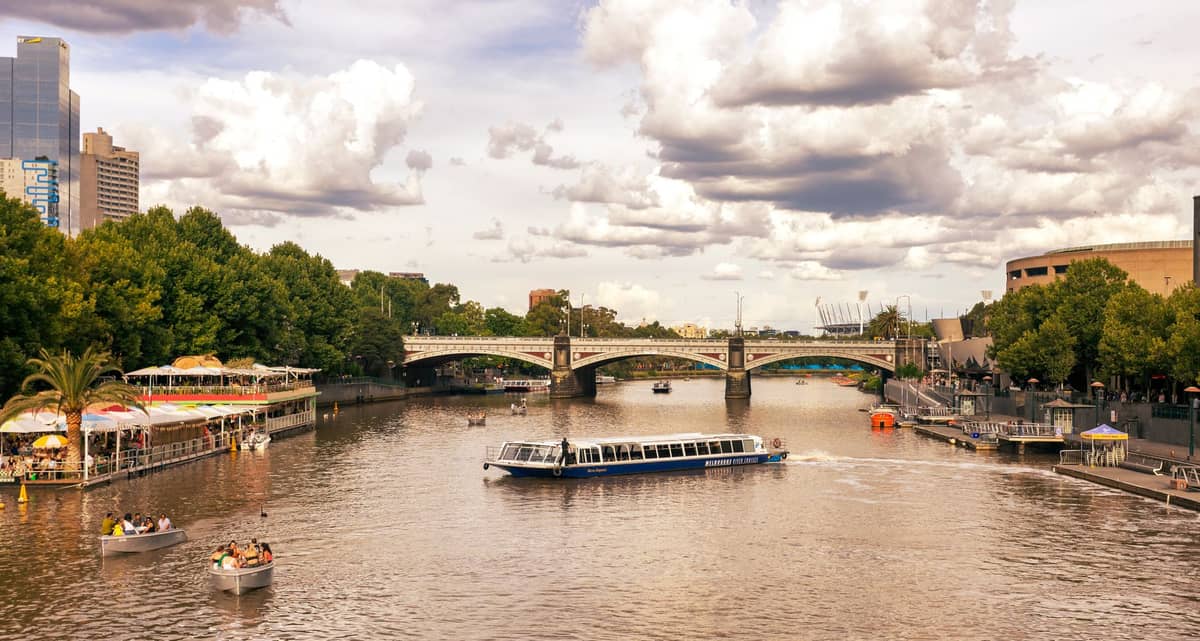
The Yarra River, known to the Wurundjeri people as Birrarung, meaning “a place of mists and shadows,” stretches 242 kilometres through Melbourne and has shaped the city since European settlement in 1835. Along its central reaches, the river offers walking paths, cycling trails, boat cruises, and a front-row view of Melbourne's evolving skyline. It is not a single ticketed attraction but an open, accessible corridor that connects many of the city's most significant precincts.
Quick Facts
- Location
- Central Melbourne, running through the CBD and Southbank precinct
- Getting There
- Flinders Street Station (most metropolitan train lines); cross the pedestrian bridge to reach the Southbank riverfront
- Time Needed
- 1–3 hours for a riverside walk; half a day if combining with cruises or nearby galleries
- Cost
- Free to walk and explore; guided walking tours from A$10 (child) / A$25 (adult); cruise and activity fees vary by operator
- Best for
- Morning walkers, cyclists, architecture enthusiasts, families, and first-time visitors orienting themselves to Melbourne
- Official website
- yarrariver.melbourne
What the Yarra River Actually Is
The Yarra River is not a single managed attraction with gates, tickets, or a reception desk. It is a living waterway, roughly 242 kilometres long, that flows from its source on Mt Baw Baw in the Yarra Ranges National Park through Melbourne's suburbs before emptying into Port Phillip Bay at Hobsons Bay. Its Wurundjeri name, Birrarung, means 'a place of mists and shadows', and that description still holds on cool mornings when low cloud sits above the water between Flinders Street and Southbank.
Melbourne's settlement was established along the lower Yarra in 1835, and the river has been central to the city's identity, commerce, and controversy ever since. For much of the nineteenth and twentieth centuries it was heavily industrialised and polluted. The past few decades have seen significant environmental remediation and urban renewal along its banks, particularly in the central precinct, making the riverfront one of the more pleasant stretches of city walking in Australia.
The river sits on the traditional lands of the Wurundjeri Woi-wurrung and Bunurong peoples of the Kulin Nation. If you want to understand more of that context before or during your visit, Birrarung Marr, the parkland directly east of Federation Square, incorporates Indigenous story markers and art along the river's edge.
ℹ️ Good to know
Access point: The easiest starting point for a riverfront walk is Flinders Street Station. Exit onto Flinders Street, cross the pedestrian bridge at Federation Square, and you are immediately on the Southbank promenade. No ticket required.
How the River Changes Through the Day
Early mornings, roughly between 6 and 8 a.m. are when the Yarra riverfront shows a different character entirely. Rowers in sculls cut the water in long, clean strokes, their oar splashes the clearest sound you will hear here all day. The promenade is occupied by joggers and dog walkers rather than tourist groups, and the light at that hour comes low and golden across the water from the east, catching the glass facades of the Southbank towers and the ironwork of the Princes Bridge.
By mid-morning the cafes on the Southbank promenade begin filling, and by noon the walking path can feel congested between Princes Bridge and the Arts Centre. This stretch is the most photographed section of the river, and it shows: groups tend to cluster at the same three or four viewpoints, particularly at the bend where the MCG's upper tiers are visible to the east. If crowd density matters to you, avoid this corridor on weekends between 11 a.m. and 2 p.m.
Late afternoon shifts the mood again. The western-facing side of the river, toward Docklands, catches direct sun in summer and autumn, while the CBD towers cast long shadows over the Southbank side. Sunset can be genuinely striking from the Sandridge Bridge, which carries a light rail track and a pedestrian walkway and frames the CBD skyline to the north. That bridge also displays a commemorative installation relating to Melbourne's immigration history, worth reading as you cross.
Tickets & tours
Live prices and dates from our booking partner. If you book, we may earn a commission at no extra cost to you.
Yarra Valley Bus Wine Tour including lunch with a glass of wine and chocolate
From 107 €Instant confirmationFree cancellationYarra Valley Gourmet full-day tour
From 113 €Instant confirmationFree cancellationGreat Ocean Road reverse itinerary tour from Melbourne
From 77 €Instant confirmationFree cancellationGreat Ocean Road bus tour with a forest walk
From 90 €Instant confirmationFree cancellation
Walking the Central Riverfront: A Practical Corridor
The most accessible and most visited section of the river runs approximately from the rowing sheds near Princes Park in the east through to Docklands in the west, but most visitors concentrate on the 2-kilometre stretch between Princes Bridge and the Bolte Bridge. You can walk this in under an hour at a casual pace, though the number of stops, viewpoints, and connecting laneways will likely extend that.
Starting at Flinders Street Station and heading east along the northern bank takes you through Birrarung Marr and eventually toward the Melbourne Cricket Ground and the Yarra Park precinct. This direction is less commercial than the Southbank side and gives a better sense of the river as a natural corridor rather than a hospitality strip.
Heading west from Princes Bridge along the southern bank puts you on the Southbank promenade, past the Arts Centre Melbourne and the NGV International (which sits just off the riverfront on St Kilda Road). Continue west and the path eventually connects to the Docklands precinct, though the walk becomes less interesting as it passes through commercial development.
💡 Local tip
Photography tip: The best elevated view of the river corridor is from the upper levels of Eureka Skydeck on the Southbank side, or from the pedestrian deck of the Bolte Bridge further west. Neither requires you to book ahead to appreciate the view from the riverbank itself.
River Cruises and Guided Activities
Several operators run cruises from Federation Wharf (Berth 1 and Berth 2), located beneath the northern bank of the river just east of Princes Bridge. Cruise durations and routes vary; some head upstream toward Richmond and the rowing clubs, others move west toward the city and Docklands. Check individual operators for current schedules and fares, as these change seasonally.
Guided walking tours along the Yarra riverfront are available through the official yarrariver.melbourne programme. At the time of writing, adult tickets are listed at A$25, concession A$21, and children A$10. Verify current pricing and tour availability on the official website before booking, as schedules depend on season and demand.
Kayak and canoe hire is available from operators on the upper Yarra sections, though the central urban stretch near Southbank is not the most practical location for paddling due to boat traffic. Cycling along the shared paths is popular and the Capital City Trail follows the river for a significant portion of its urban loop.
⚠️ What to skip
Water quality: The Yarra's water in the urban reaches is not safe for swimming. Do not enter the water near the CBD. Melbourne Water provides water quality advisories, particularly after heavy rainfall when runoff can significantly affect conditions.
Historical and Cultural Weight
The river's history is layered in ways that take some effort to read on the ground. John Batman arrived at Port Phillip in 1835 and identified the lower Yarra as the site for settlement, a decision that began the displacement of the Wurundjeri people from country they had inhabited for tens of thousands of years. That history is not prominently surfaced along the promenade itself, which tends toward contemporary hospitality rather than historical interpretation.
The built environment tells a different story of layers. Princes Bridge, which crosses the Yarra at Swanston Street, dates to 1888 and is a bluestone and granite structure with ornate lamp standards. Flinders Street Station, whose ochre dome and clocks define the northern riverbank, opened in its current form in 1905. These are not incidental backdrops; they are among the most significant pieces of civic architecture in Victoria.
For visitors interested in Melbourne's architectural evolution, the river corridor provides one of the best cross-sections in the city, from Victorian-era public buildings to the 1990s Southbank development to contemporary towers. The Melbourne architecture guide provides detailed context for what you are looking at from the riverbank.
Practical Considerations Before You Go
Melbourne's weather is famously changeable, and the riverfront is fully exposed to wind. Even on days that start warm, a temperature drop of 10 degrees within a few hours is not unusual, particularly in spring. Bring a layer you can add or remove, and check the Bureau of Meteorology forecast rather than relying on the morning conditions.
The paved promenade surface is flat and generally smooth, making the main Southbank section accessible for wheelchairs and prams. However, some connecting paths and bridge approaches have steps or uneven surfaces, so specific routes should be checked in advance. The City of Melbourne notes that accessibility details for cruise berths are self-reported by operators and not independently verified.
Getting there by public transport is straightforward. All metropolitan train lines stop at Flinders Street Station, and the City Circle Tram and multiple other tram routes run along Flinders Street. On-street parking in the central city is limited and metered; commercial car parks are available nearby but add cost and time to a visit that works better without a vehicle.
The riverfront promenade is free to walk at all hours, though individual venues, cruise operators, and activity providers set their own hours and fees. There is no single authority managing the entire river corridor as a visitor attraction.
💡 Local tip
If you are visiting during summer (December to February), the afternoon westerly wind known locally as the 'Fremantle Doctor' equivalent can make the riverfront noticeably cooler after 3 p.m. Morning walks in summer are more comfortable and less crowded.
Insider Tips
- The Sandridge Bridge, a converted rail bridge east of Princes Bridge, is often overlooked by first-time visitors. Its pedestrian walkway carries a permanent installation of figures representing Melbourne's waves of immigration. Cross it for a less-crowded view of the CBD skyline and the river bend.
- Rowing on the Yarra is a serious Melbourne institution. If you are on the river before 8 a.m. on weekday mornings, you will see club crews training in eights and fours. The stretch between Princes Bridge and the Henley-on-Yarra boathouse is the most active. It is worth timing a walk just to watch.
- The northern bank path between Federation Square and Birrarung Marr is significantly quieter than the Southbank promenade even at peak times, and gives better views back toward Flinders Street Station and Princes Bridge. Most tourists gravitate to the southern side; cross back north for the cleaner sightlines.
- Guided walking tours through the official yarrariver.melbourne programme cover sections of the river not well-served by signage, including Indigenous cultural context that the promenade itself does not explain clearly. These are worth the cost if you want more than a scenic walk.
- The river's condition after heavy rain changes noticeably: the water turns a deep brown from sediment, the smell intensifies, and floating debris appears. If Melbourne has had significant rainfall in the 24 hours before your visit, the visual experience is considerably less appealing than on clear days.
Who Is Yarra River For?
- First-time visitors to Melbourne who want to understand how the city is laid out geographically and architecturally
- Morning walkers and joggers who prefer a flat, riverside route away from the main shopping streets
- Cyclists using the Capital City Trail, which follows the Yarra through the inner city
- Families with prams or young children, given the flat promenade surface and open space in Birrarung Marr
- Architecture and history enthusiasts who want to read Melbourne's development through its riverbank buildings
Nearby Attractions
Other things to see while in Melbourne CBD:
- AC/DC Lane
Renamed in 2004 to honour one of Australia's most iconic rock bands, AC/DC Lane is a compact CBD laneway lined with street art, live music venues, and a raw energy that sets it apart from Melbourne's more polished laneways. Free to visit at any hour, it rewards those who show up after dark.
- Australian Centre for the Moving Image (ACMI)
The Australian Centre for the Moving Image (ACMI) sits at the heart of Federation Square and traces the full arc of screen culture, from silent cinema to interactive digital art. General entry and the permanent exhibition are free, making it one of the most rewarding stops in the Melbourne CBD regardless of your budget or the weather outside.
- Birrarung Marr
Birrarung Marr is a free, open-access riverside park on the northern bank of the Yarra River, a short walk from Flinders Street Station. Built on a former railway yard and opened in 2002, it offers terraced lawns, Indigenous cultural context, city skyline views, and a calendar of public events that transforms the space throughout the year.
- The Block Arcade
Built between 1892 and 1893, The Block Arcade is Melbourne's finest Victorian-era shopping arcade, a covered gallery of mosaic tile floors, ornate plasterwork, and a soaring glazed roof on Collins Street. Free to enter and open daily, it rewards slow exploration and offers one of the CBD's most atmospheric pauses from street-level traffic.
Planning a trip? Discover personalized activities with the Nomado app.