Valle di Lanaittu: Caves, Springs, and Ancient Ruins in the Heart of the Supramonte
Valle di Lanaittu is a rugged limestone valley in the Supramonte highlands of central Sardinia, straddling the municipalities of Oliena and Dorgali in the Province of Nuoro. It serves as the most accessible entry point into one of the island's most ancient and geologically complex landscapes, where prehistoric cave systems, Nuragic ruins, and cold underground springs converge in a single wild corridor.
Quick Facts
- Location
- Between Oliena and Dorgali, Province of Nuoro, Barbagia, Sardinia
- Getting There
- By car from Oliena (approx. 8 km) or Dorgali via local roads and dirt tracks; no public transit serves the valley directly
- Time Needed
- Half day for a basic visit; full day for hiking to Tiscali or exploring multiple cave systems
- Cost
- The valley itself is free to enter; individual caves and archaeological sites charge separate fees (verify locally)
- Best for
- Hikers, geology and archaeology enthusiasts, photographers, and travelers seeking authentic inland Sardinia
- Official website
- www.sardegnaturismo.it/en/explore/valley-lanaitto
What Is Valle di Lanaittu?
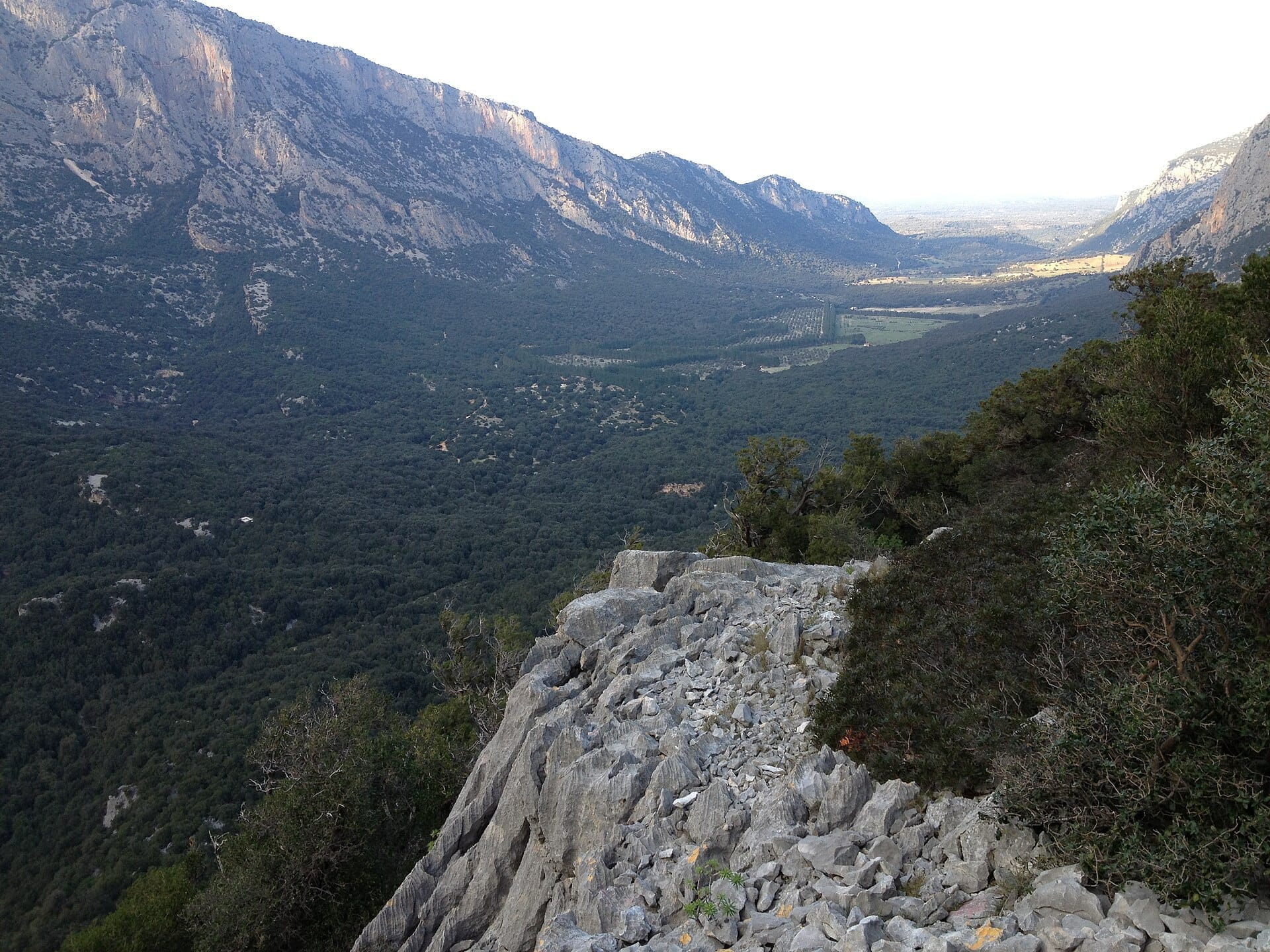
Valle di Lanaittu (also written as Valle di Lanaitto or Valle di Lanaitho in older cartographic sources) is a deep, limestone-carved valley within the Supramonte massif of central Sardinia. It runs in the territories of Oliena and Dorgali, both in the Province of Nuoro, and represents one of the most accessible gateways into one of the most geologically and archaeologically dense areas on the island.
The Supramonte itself is a vast karst plateau, and Lanaittu is one of its most storied interior valleys. The terrain is shaped by millennia of water dissolving the grey limestone bedrock, producing sinkholes, subterranean rivers, cave chambers, and springs that emerge cold and clear from the rock. Above ground, the valley floor and slopes are covered in holm oaks and wild olives, punctuated by pale cliff faces that glow amber in late afternoon light.
What draws serious visitors here is not a single attraction but a layered concentration of them: the prehistoric cave settlement of Tiscali Nuragic Village, cave systems with their own names and access arrangements, and the underground springs that feed the valley's year-round water. This is the kind of place where natural history and human history are difficult to separate.
ℹ️ Good to know
The valley has no fixed entrance gate or staffed visitor center. Access is open, but trails are unpaved and involve rocky, uneven terrain. Bring water, sturdy footwear, and a paper or offline map — mobile signal can be unreliable once you descend into the valley.
The Landscape: What You Actually See
Arriving at Lanaittu from Oliena, the first thing you notice is the change in air temperature. The valley sits lower than the surrounding plateau, and moisture from the underground springs keeps it noticeably cooler and more humid than the scorched hills around it in summer. The smell shifts too: dry limestone dust gives way to damp earth and crushed wild herbs underfoot.
The valley walls are sheer in places, rising as pale grey cliffs that have been sculpted into rounded overhangs and narrow fissures by centuries of erosion. In the lower sections, the ground opens into wider grassy stretches where the light filters through the oak canopy and lands in shifting pools on the valley floor. Goats and horses sometimes wander here, adding to the sense that this landscape has been used, continuously, for thousands of years.
Water is a constant presence. Springs emerge from cracks in the rock, feeding small streams that are audible before they are visible. In early morning, before the sun reaches the valley floor, mist can hang at mid-height on the cliff faces. By midday in summer, that coolness is gone from the exposed sections, so morning starts are not just preferable — they are more comfortable.
Tickets & tours
Hand-picked options from our booking partner. Prices are indicative; availability and final rates are confirmed when you complete your booking.
Santa Teresa di Gallura hiking tour of Valle della Luna
From 30 €Instant confirmationFree cancellationVineyard Guided Tour and 7 Wine Tasting in Palau
From 84 €Instant confirmationFree cancellationFull-Day Sailboat Tour in La Maddalena Archipelago from Cannigione
From 112 €Instant confirmationFree cancellationHiking excursion to the Devil's Saddle
From 35 €Instant confirmationFree cancellation
The Caves: Sa Oche, Su Bentu, and Others
Several cave systems lie within and adjacent to Lanaittu. Among the most significant are Sa Oche and Su Bentu, which together form one of the longest known cave systems in Sardinia. These are not show caves with guided walkways and electric lighting — they require proper caving equipment and in some cases an experienced local guide to enter safely. Access arrangements and any associated fees should be verified directly with local operators or the relevant municipality before visiting.
Even for visitors who have no intention of entering the cave systems, their presence shapes the valley in visible ways. You can see cave mouths opening in the cliff faces, some at ground level and some elevated partway up the rock. The mouths of Sa Oche and Su Bentu draw cold air outward in summer, and standing near them is one of the valley's more unexpected sensory experiences: a sudden chill in the face, and a faint mineral smell from deep underground.
⚠️ What to skip
Do not attempt to enter unmarked cave openings without a licensed guide. The cave systems in this area are extensive and complex. Getting lost underground is a genuine risk, and rescue operations in this terrain are difficult.
Tiscali: The Nuragic Village Inside a Mountain
The most compelling archaeological site accessible from Lanaittu is Tiscali, a Nuragic settlement built inside a collapsed karst sinkhole near the summit of Monte Tiscali. The site is extraordinary in concept: an entire village concealed within the mountain itself, with its stone huts constructed under natural rock overhangs inside a vast cave chamber open to the sky.
The hike to Tiscali from the valley floor takes roughly 1.5 to 2 hours each way, depending on pace and conditions. The trail climbs through limestone terrain and involves some scrambling. It is a proper mountain hike, not a casual walk, and should not be attempted without adequate water, sun protection, and footwear with grip. The route is marked but not always obvious on the steeper sections.
At the site itself, the scale of the sinkhole creates a disorienting sense of enclosure and openness simultaneously: you are inside a mountain, but light pours in from above. The stone structures of the Nuragic settlement are partially reconstructed and partially ruined, giving a clear sense of how densely the space was once inhabited. Tiscali is thought to have been occupied into the Roman period, possibly by communities deliberately retreating from lowland contact.
For context on how Tiscali fits into the broader Nuragic story across Sardinia, the Sardinia Nuragic sites guide covers the major prehistoric monuments island-wide, from the towers of the coastal plain to the remote mountain settlements of the interior.
When to Visit and How the Valley Changes by Season
Spring (April to early June) is the most rewarding time to visit. The valley floor is green, wildflowers push through the limestone scree, and the springs are running at their strongest after winter rains. Temperatures on the valley floor are mild in the mornings, rarely uncomfortable by midday, and the light is excellent for photography from mid-morning onward.
Summer visits are possible but demanding. The Supramonte sits at elevation compared to the coast, so temperatures in the valley are lower than at Cagliari or on the beaches, but midday on exposed trail sections can still be seriously hot. If you are visiting in July or August, start no later than 7am for the Tiscali hike, carry at least two liters of water per person, and plan to be back at your vehicle before noon.
Autumn brings a different quality of light: richer and more directional, with the oak leaves beginning to turn. The valley is quieter than in summer and the walking conditions improve as temperatures drop. Winter visits are for the committed — the trails can be muddy and some sections slippery on wet limestone. But the valley in January, with low mist and no other visitors, has a stillness that the summer version never achieves.
💡 Local tip
The best light for photography in the valley is between 8am and 10am in summer, when the sun is low enough to catch the cliff faces without overexposing the sky. In spring and autumn the window extends to around 11am.
Getting There and Moving Around the Valley
There is no public transport serving Valle di Lanaittu directly. A private vehicle is effectively essential. The two main approach routes are from Oliena to the northwest and from Dorgali to the east. From Oliena, take the SP46 road toward the Supramonte; from Dorgali, the approach involves local roads that transition to dirt tracks as you descend toward the valley. Both routes are manageable in a standard car in dry conditions, but a vehicle with higher ground clearance is preferable on the final dirt sections.
The nearest towns with accommodation and services are Oliena and Dorgali. Both are worth time in their own right: Oliena sits below the Supramonte with views up toward the cliffs, while Dorgali is the gateway to the Cala Gonone coast and the Golfo di Orosei. If you are planning a longer stay in the area, either town makes a practical base. Renting a car from Nuoro (the provincial capital, about 20 km from Oliena) is a sensible option.
Lanaittu fits naturally into a wider exploration of the Barbagia interior. The region around Nuoro rewards travelers who are willing to move slowly and cover ground by road — a Sardinia road trip that includes the Supramonte, the Gennargentu range, and the gorges of the east coast gives this valley its full context.
Practical Details at a Glance
- The valley area is free to access; individual caves and the Tiscali archaeological site may charge entry fees — verify locally before visiting.
- No facilities (toilets, cafes, water points) are available within the valley itself. Carry everything you need.
- Trails are unpaved, rocky, and in places steep. Proper hiking footwear is required — not trail runners or sandals for the Tiscali route.
- Mobile signal is patchy to non-existent in the lower valley. Download offline maps before leaving your accommodation.
- The valley is not wheelchair accessible and there are no adapted facilities of any kind.
- Dogs are commonly brought on trails here by local hikers, but check current access rules for any specific site.
For travelers combining this visit with the broader Barbagia region, the hiking in Sardinia guide covers trail grades, preparation, and the best multi-day routes through the island's interior highlands.
Insider Tips
- If you want to visit both the valley and Tiscali in a single day, park at the trailhead near the valley floor rather than driving to a higher point — the approach through the valley itself adds crucial context to what you find at the top, and the trail is more coherent walked from bottom to top.
- Local guiding cooperatives based in Oliena offer half-day and full-day excursions into Lanaittu that include cave access not available to solo visitors. These are worth booking even if you are an experienced hiker, purely for the cave access they provide.
- The spring at Su Gologone, just a few kilometers from the valley on the Oliena side, is one of the most powerful karst springs in the Mediterranean and emerges with enough force to be visually dramatic even in dry summers. It takes 20 minutes to visit and rounds out the hydrology story of the whole area.
- Bring a light layer even in August. The shaded sections of the valley and the air near cave mouths can drop your body temperature faster than you expect after sweating on an uphill section.
- If you are visiting in September or October, check whether any local festivals in Oliena or Dorgali coincide with your dates. The towns of the Barbagia interior hold autumn food and culture events that are worth timing your visit around.
Who Is Valle di Lanaittu For?
- Hikers and trekkers seeking serious terrain away from the coast
- Archaeology and history travelers interested in Nuragic civilization in its original landscape context
- Photographers looking for dramatic limestone scenery with good morning light
- Travelers who have done the coast and want to understand Sardinia's interior character
- Geology enthusiasts interested in karst landscapes, cave systems, and underground hydrology
Nearby Attractions
Other things to see while in Barbagia & Nuoro:
- Giara di Gesturi
Rising to around 550 metres above central Sardinia, the Giara di Gesturi is a 45-square-kilometre basalt plateau formed by Oligocene volcanic activity. Cork oak forests, seasonal wetlands, and an extraordinary population of small wild horses make it one of the most ecologically singular landscapes on the island.
- Gola di Su Gorropu
Gola di Su Gorropu is a karst canyon in Sardinia's Supramonte massif with walls rising over 500 metres and passages as narrow as 4 metres across. It's a serious hiking destination that rewards physical effort with one of the most dramatic landscapes in the Mediterranean.
- Monte Ortobene
Reaching a maximum elevation of 955 metres above sea level near the inland city of Nuoro, Monte Ortobene is a forested mountain with panoramic views across central Sardinia, a landmark bronze statue of Cristo Redentore, and walking paths through fragrant Mediterranean scrubland. Access is free, the road reaches the summit, and the atmosphere is unlike anything on the coast.
- Murales di Orgosolo
Orgosolo, a small hill town in the Barbagia region of central Sardinia, has covered its streets in around 150 murals since the late 1960s. Free to visit at any hour, the Murales di Orgosolo form one of the most politically charged and visually striking open-air art experiences in Italy.