Undercliff Walk Brighton: The Complete Guide to the Chalk Cliff Coastal Path
The Undercliff Walk stretches just over 5km along Brighton's eastern coast, running between Brighton Marina and Saltdean beneath towering white chalk cliffs. Free, flat, and open year-round, it offers some of the most dramatic coastal scenery in East Sussex without the crowds of the main seafront.
Quick Facts
- Location
- Brighton Marina to Saltdean, Brighton, East Sussex
- Getting There
- Bus stops at Brighton Marina, Roedean Café, Rottingdean, and Saltdean
- Time Needed
- 1.5 to 2.5 hours for the full 5km one-way; shorter sections possible
- Cost
- Free — no admission charge
- Best for
- Walkers, runners, cyclists, families with pushchairs, anyone wanting sea air away from the main seafront
What the Undercliff Walk Actually Is
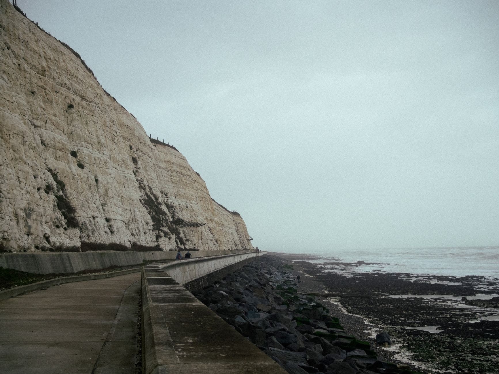
The Undercliff Walk is a paved, traffic-free coastal path that runs for just over 5km (about 3 miles) along the base of Brighton's eastern chalk cliffs, from Brighton Marina all the way to the city boundary at Saltdean. It sits in a narrow strip between the cliff face and the English Channel, sheltered by the chalk above and open to the sea on the other side. There is no equivalent path elsewhere along this stretch of coast, and that geography is what makes it genuinely distinctive.
The path is entirely flat, fully paved, and wide enough for cyclists and walkers to share comfortably. Brighton & Hove City Council maintains it as a public right of way with no charge, no booking system, and no gates. You simply arrive at one of several access points and start walking.
⚠️ What to skip
Parts of the Undercliff Walk are occasionally closed at short notice when the cliffs become unstable. Chalk and flint falls do happen. Always check current closures with Brighton & Hove City Council before planning a visit if you intend to walk the full length.
The History Behind the Path
Construction of the Undercliff Walk began in 1931, primarily as a coastal defence project to protect the chalk cliffs from wave erosion rather than as a leisure amenity. The work involved cutting back and stabilising the cliff base, then constructing the concrete sea wall that the path runs alongside. Construction continued until final completion in 1935.
That engineering context is worth keeping in mind as you walk. The cliffs themselves are natural chalk, formed from marine sediments laid down during the Cretaceous period, roughly 70 to 100 million years ago. The white wall rising above you as you walk is some of the most geologically significant landscape in East Sussex, the same formation that produces the famous Seven Sisters cliffs further along the coast. The concrete path at its base is, in a sense, an attempt by 1930s civil engineers to hold back the sea from eroding that landscape.
The walk sits within the broader coastal strip that connects Brighton's eastern end to the villages of Ovingdean and Rottingdean, the latter a historic downland village that has remained relatively unchanged despite urban expansion. It provides one of the few continuous walking routes from the city into the surrounding coast without using a road. For context on the wider Brighton seafront experience, see the Brighton Beach guide, which covers the main seafront west of the Marina.
Tickets & tours
Hand-picked options from our booking partner. Prices are indicative; availability and final rates are confirmed when you complete your booking.
Explore Brighton self-guided walking tour using an app
From 11 €Instant confirmationBrighton Walk 360
From 46 €Instant confirmationBrighton city lights flight with welcome drink
From 21 €Instant confirmationCycle along the beachfront with Brighton Beach Bikes hire
From 7 €Instant confirmationFree cancellation
What You'll See Walking the Path
Starting from Brighton Marina, the first section of the walk has the most urban character. The Marina's apartment blocks and boat storage facilities are visible above. Within the first ten minutes, though, the cliff height increases and the built environment above recedes. By the time you reach the area below Roedean School, whose red-brick Victorian buildings perch dramatically on the cliff top, the setting feels distinctly less city and more coast.
The chalk face to your left changes texture and colour depending on the light. On overcast mornings, it reads as a flat pale grey. In afternoon sun, particularly in summer, it takes on a warm cream tone and the flint layers embedded in the chalk become visible as dark horizontal bands. Loose chalk sits at the cliff base in places — a reminder that this is active geology, not a decorative backdrop.
The sea is always to your right. Depending on weather and tidal conditions, the colour ranges from a glassy green-grey to a deep slate blue. On clear days, you can see container ships moving across the Channel. The sound of the walk alternates between wind off the water, waves against the sea wall, and the occasional rush of a cyclist passing behind you. Seabirds, mainly herring gulls and occasionally fulmars, use the cliff face throughout the year.
The eastern end of the walk, approaching Rottingdean and then Saltdean, opens up as the cliff height gradually decreases. Rottingdean itself is reachable via the path, and its beach, tea rooms, and historic village green are worth a stop. The Volks Electric Railway operates separately along the western seafront and doesn't connect to the Undercliff, but it gives useful context for Brighton's tradition of unusual coastal infrastructure.
How the Experience Changes by Time of Day and Season
Early morning, particularly on weekdays, the Undercliff Walk has almost no pedestrian traffic. Runners use it regularly from around 6am, and the light at this hour, especially in summer, is exceptional. The low sun catches the chalk from an angle that makes it glow, and the Channel surface reflects colour in a way that it doesn't do at midday. This is the best time for photography and for experiencing the path without sharing it.
By late morning on weekends, particularly from May through September, the walk becomes significantly busier. Families with pushchairs, dog walkers, and cyclists all appear in number. The path is wide enough that this doesn't feel cramped, but if quiet solitude is what you're after, late morning on a Saturday in August is not the time to come.
In winter, the walk takes on a different character entirely. Crowd levels drop sharply, and the coastal exposure becomes more apparent. Wind can be strong along the open stretches, and high tides combined with rough weather occasionally push waves over the sea wall onto the path. The council advises caution in these conditions, and it's a genuine consideration — some sections can become wet and slippery. Bring a wind-resistant layer even if the air temperature seems mild, as the Channel wind has a cutting quality that isn't obvious from the forecast.
💡 Local tip
The section between Ovingdean Gap and Rottingdean tends to be the least busy even during peak summer weekends. If you want to experience the walk without the busier western end near the Marina, access via the stairs at Ovingdean Gap opposite Greenways and walk east.
Getting There and Practical Logistics
The Undercliff Walk has multiple access points, which means you don't need to walk the full 5km unless you want to. Brighton & Hove Buses serve stops at Brighton Marina, Black Rock (Marine Gate), Roedean Café on Marine Drive, the Marine Drive/Greenways junction, Rottingdean, and Saltdean — covering essentially the full length of the path from above. Check current timetables with Brighton & Hove Buses before travel, as routes and schedules are subject to change.
From Brighton city centre, the Marina end of the walk is reachable on foot via the main seafront promenade in around 30 to 40 minutes, passing the Palace Pier and continuing east along Madeira Drive. Cyclists can follow the same route. There is car parking at Brighton Marina if you're driving, though availability and charges should be verified locally.
Access ramps at the entry points make the walk step-free throughout. The surface is firm, even tarmac or concrete, appropriate for wheelchairs, mobility scooters, and pushchairs. The walk does not involve any significant gradient. Dogs are permitted, and the path is popular with dog walkers throughout the year.
If you're spending a full day on the eastern seafront, the Undercliff Walk pairs well with a visit to Brighton Palace Pier as a starting point before heading east, or with a stop at the Brighton Fishing Museum near the arches on your way out. For those planning a broader coastal day, the best beaches in Brighton guide covers how the stretch fits into the wider seafront picture.
Photography and Practical Tips for Getting the Most from the Walk
The western end of the path, from the Marina to roughly below Roedean, gives the best views back toward Brighton's seafront skyline including the i360 tower. This perspective, with the chalk cliff in the foreground and the city in the distance across the bay, is one that most visitors to Brighton don't ever see because it requires walking east first.
The chalk cliff itself is best photographed in afternoon light when shadows define the texture of the face. Abstract compositions focusing on the dark flint bands against white chalk work particularly well. The sea wall and path surface, both weathered concrete, add industrial texture against the natural cliff background.
There are very few cafes or facilities on the path itself. Rottingdean, reachable roughly midway from the Marina end, has a small village with shops and places to eat — useful if you're planning the full length. Carry water, particularly in summer.
ℹ️ Good to know
The Undercliff Walk is not lit at night. After dark, sections away from the access points have no artificial lighting, which is worth factoring into plans if you're walking in autumn or winter when daylight hours are short.
Who Should Reconsider This Walk
The Undercliff Walk is not for everyone. Visitors looking for a short, convenient attraction with facilities nearby may find the logistics — the distance from central Brighton, the lack of cafes on the path, the exposure to weather — more effort than the payoff justifies for a brief visit. If you have limited time in Brighton and want to cover the main highlights, there are more concentrated areas of interest.
Anyone with a strong fear of heights or unstable terrain should be aware that chalk falls from the cliff face do occur, and signs alerting walkers to this are present along the route. The risk is low, but it's real. Similarly, in rough weather with high tides, the exposed sections are genuinely uncomfortable rather than pleasantly dramatic. The Brighton in winter guide has broader advice on managing weather expectations during the colder months.
Insider Tips
- Walk west to east (Marina toward Saltdean) in the morning so the sun is behind you illuminating the cliff face ahead. Reverse the direction for afternoon light on the sea.
- The access ramp from the Asda car park at Brighton Marina is the least scenic entry point. For a more immediate sense of the cliffs, enter via the Roedean Café access point on Marine Drive instead.
- Rottingdean is worth building into your plan as a midpoint stop. The Plough Inn on the High Street and several tea rooms near the village green provide a welcome break before continuing to Saltdean or returning.
- If the full 5km feels ambitious, the stretch from Ovingdean Gap to Rottingdean, about 1.5km, gives you the most dramatic section of cliff without committing to the whole route.
- Check the Brighton & Hove City Council website before visiting to confirm there are no active closures. After storms or heavy rain, sections near the base of loose chalk areas may be temporarily shut.
Who Is Undercliff Walk For?
- Walkers and runners wanting a flat, traffic-free coastal route away from the main seafront crowds
- Families with pushchairs or prams who need an accessible outdoor route with genuine scenery
- Photographers interested in coastal geology, chalk cliff textures, and open sea compositions
- Cyclists looking for a seafront route with less pedestrian congestion than the central promenade
- Anyone on a return visit to Brighton who has already covered the main attractions and wants to see a less visited side of the coast
Nearby Attractions
Combine your visit with:
- Booth Museum of Natural History
Founded in 1874 by naturalist Edward Thomas Booth, the Booth Museum of Natural History is Brighton's free natural history collection housed in a Grade II listed Victorian building on Dyke Road. With over 525,000 specimens, from British birds to butterfly drawers and dinosaur bones, it is one of the most significant natural history collections in southern England. Note: closed to the public since 20 April 2025 for essential works; special event days only, with reopening targeted for later 2026 or early 2027.
- Brighton Racecourse
Perched on Whitehawk Hill roughly a mile from the coast, Brighton Racecourse is one of England's most unusual flat racing venues. The horseshoe-shaped track, open from April to October, offers panoramic views across the city and out to the English Channel, alongside a race day atmosphere that ranges from relaxed midweek afternoons to packed summer festivals.
- Devil's Dyke
Perched around 215 metres above sea level on the South Downs, Devil's Dyke is a National Trust countryside site just north of Brighton. Claimed to be the longest, deepest and widest dry valley in Britain, it offers panoramic views stretching from the English Channel to the Surrey Hills, free access year-round, and walking routes ranging from a gentle ridge stroll to a steep valley descent.
- Preston Manor
Preston Manor is a Grade II* listed historic country house museum in Brighton, open seasonally beside Preston Park. With rooms preserved as they were in 1905 and a history recorded in the Domesday Book, it offers a rare glimpse into upper-middle-class Edwardian life — a world away from the seafront crowds.