Tufia Archaeological Site: Gran Canaria's Forgotten Coastal Settlement
Perched on a rocky promontory above the Atlantic in Telde municipality, the Tufia Archaeological Site preserves one of Gran Canaria's most atmospheric pre-Hispanic settlements. Cave dwellings opening directly to the sea, dry-stone house clusters, and burial grounds tell the story of aboriginal Canarian life between the 4th and 9th centuries AD.
Quick Facts
- Location
- Telde municipality, east coast of Gran Canaria, near Playa de Tufia
- Getting There
- Bus line 2 from Las Palmas toward Telde (alight near El Goro for access to Tufia); by car via GC-1 exit 13 'El Goro', then ~3 km signposted
- Time Needed
- 1 to 2 hours for independent visit; guided visits may run longer
- Cost
- Open-air area freely accessible; guided visits via Cabildo de Gran Canaria (book in advance, fees vary)
- Best for
- History enthusiasts, photography, coastal walks, archaeology
- Official website
- turismo.telde.es/en/what-to-see/archaeology/tufia-site
What Is the Tufia Archaeological Site?
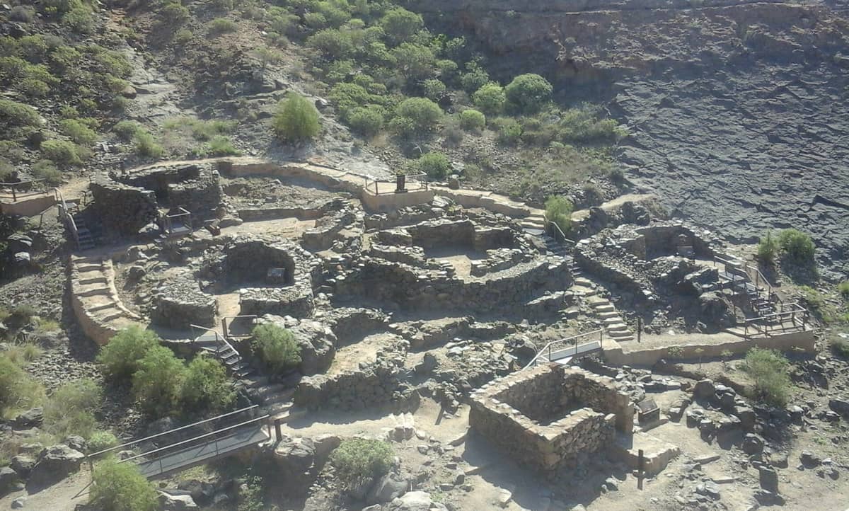
The Tufia Archaeological Site, known in Spanish as Yacimiento Arqueológico de Tufia, sits on a wave-cut volcanic promontory between Playa de Tufia and Playa de Aguadulce on Gran Canaria's eastern coast. It is one of the most complete surviving examples of aboriginal Canarian settlement on the island, combining two distinct types of pre-Hispanic architecture: cave dwellings carved into or formed by the coastal rock, with their openings facing directly over the Atlantic, and clusters of dry-stone surface houses arranged in loose nuclei across the headland.
The site dates broadly between the 4th and 9th centuries AD, predating the Castilian conquest of the Canary Islands by centuries. Its inhabitants were the Guanche-related aboriginal Canarians who settled these coasts long before European contact. The settlement was declared a Historic-Artistic Monument on 5 July 1973 and is today classified as a Bien de Interés Cultural (BIC), Zona Arqueológica under Spanish national heritage law, one of the highest protection categories available for archaeological sites.
ℹ️ Good to know
Guided visits to Tufia must be booked in advance through the Cabildo de Gran Canaria. The open-air promontory area is accessible independently, but a guide adds significant archaeological context that is difficult to piece together from site signage alone.
The Settlement in Detail: What You Are Actually Looking At
Standing on the promontory, the first thing that registers is the scale. This is not a reconstructed heritage park with labeled replicas. The stone walls that survive are original, low and dark with volcanic basalt, their courses laid without mortar in the ancient Canarian technique. Some structures are barely knee-high; others retain enough height to suggest enclosed rooms. Underfoot, the rock is rough and uneven, worn smooth only in narrow paths that locals and visitors have traced over decades.
The cave dwellings are the more visually arresting element. They occupy the seaward face of the promontory, where natural hollows in the volcanic rock were adapted, deepened, and in some cases shaped into usable living spaces. Standing at the edge and looking down, you can see why this location was chosen: the elevated position gives clear sightlines across the water, the cave openings face away from prevailing winds, and the rock itself offers thermal mass that moderates interior temperature. It is a logical, efficient settlement choice, not a dramatic one.
Associated burial grounds complete the picture of a permanent, organized community rather than a temporary camp. The juxtaposition of living spaces and burial areas within a compact headland reflects patterns seen at other Guanche-period sites across the island, including the much larger necropolis at Arteara in the south.
For broader context on Gran Canaria's pre-Hispanic heritage, the Museo Canario in Las Palmas holds the island's primary collection of aboriginal artifacts, skeletal remains, and ethnographic material. Visiting there before Tufia gives you the vocabulary to read the landscape far more clearly.
How the Site Changes Through the Day
Morning visits, especially on weekdays, offer near-solitude. The eastern orientation of the promontory means low morning sun hits the stone walls at an angle that brings out their texture and colour, shifting from dark grey-black in shadow to warm amber where the light catches. The sound at this hour is mainly wind and surf; the GC-1 motorway is audible in the background but does not dominate.
By midday in summer, the exposed headland becomes genuinely hot. There is no shade on the promontory itself, and the dark volcanic rock radiates heat upward. This is also when beachgoers begin to arrive at the adjacent Playa de Tufia, a small sandy cove that draws a loyal local crowd. The contrast between the ancient settlement and the beach umbrellas below is striking, and not entirely comfortable.
Late afternoon light, particularly in autumn and winter, produces the most photogenic conditions. The sun moves around to illuminate the cave openings from the side rather than washing them out, and the sea takes on deeper colour. Winter afternoons can be cool and breezy, which is actually more comfortable for unhurried exploration of the rocky paths.
💡 Local tip
Go early on a weekday morning for the best combination of good light, cool temperatures, and minimal foot traffic. Avoid weekend midday visits in July and August: the beach below fills up, the promontory gets crowded and uncomfortably hot, and the experience loses its contemplative quality entirely.
Getting There: Practical Directions
By car, take the GC-1 motorway and exit at junction 13, signed El Goro. From there, brown heritage signage directs you along approximately 3 km of local road to the Tufia area. Parking near the beach is limited and fills quickly on summer weekends. Arriving before 10:00 makes a significant difference.
By public transport, bus line 2 from Las Palmas runs toward the Tufia area. Gran Canaria's interurban bus network, operated by Global, covers the main coastal corridor, though frequency on this route is lower than on the major resort lines. Verify current timetables before travelling, as schedules change seasonally. The walk from the bus stop to the promontory is short but involves some uneven ground.
If you are planning a broader day on the east coast and want to combine Tufia with other stops, the Gran Canaria transport guide covers car hire, bus routes, and the Global network in detail.
Practical Walkthrough: What to Expect on Arrival
The site is fenced, and access points are gated. Recent conservation works have replaced access gates and repaired protective fencing, so the perimeter is clearly defined. Signage exists but is not extensive; without a guide, you are largely reading the landscape through your own observation. Interpretation panels provide some historical grounding but do not substitute for a knowledgeable guide.
Wear proper shoes. The promontory surface is volcanic rock with irregular edges, loose small stones in places, and slopes that require attention. Sandals are a poor choice. Sun protection is essential in summer and advisable year-round on this exposed coastal site.
Photography: the site does not have restrictions on personal photography for non-commercial purposes. Wide-angle shots from the seaward edge of the promontory capture both the structural remains and the Atlantic backdrop effectively. A polarising filter helps manage glare from the water during midday visits. Drone use requires prior authorization under Spanish aviation regulations; do not assume permission.
⚠️ What to skip
The promontory edges are unfenced in places and drop sharply to the sea. Keep children close and avoid the edges, particularly when it is windy. The rock can be slippery if there has been recent spray or light rain.
Accessibility and Who Should Manage Expectations
The Cabildo de Gran Canaria describes the Tufia route as 'sin dificultad' (without difficulty) for standard visitor groups of 10 to 30 people. This refers to general fitness level, not wheelchair or mobility-aid accessibility. The rocky, uneven terrain of the promontory makes independent access very difficult for wheelchair users or those with significant mobility limitations. There are no paved or leveled paths across the site itself.
Visitors who expect a polished heritage experience with reconstructed structures, multilingual audio guides, and on-site facilities will be disappointed. There are no visitor center buildings, no café, and no toilets at the site. The beach nearby has some seasonal facilities. Tufia rewards visitors who are comfortable with raw, unmediated access to an ancient place and are willing to bring their own context.
For those who want a more fully interpreted pre-Hispanic experience, Cueva Pintada in Gáldar offers a purpose-built museum and one of the most significant collections of aboriginal Canarian painted caves in the archipelago, with proper visitor infrastructure.
Tufia in the Wider Archaeological Landscape of Gran Canaria
Gran Canaria has a remarkable density of pre-Hispanic sites for an island of its size. Tufia is one piece of a broader pattern of coastal and mountain settlements, cave complexes, and burial grounds left by the Guanche-era populations. Understanding where Tufia fits requires some awareness of the island's archaeology as a whole.
The interior of the island holds some of the most dramatic sacred landscapes, including Roque Bentayga, a towering monolith with associated aboriginal ritual sites, and the cave granary complex of Cenobio de Valerón near Santa María de Guía, one of the most architecturally complex pre-Hispanic structures on the island. Tufia, by contrast, represents everyday residential life: a fishing and farming community that chose a defensible coastal position and built to last.
The municipality of Telde itself has deep pre-Hispanic roots and was one of the two major kingdoms of aboriginal Gran Canaria before the Castilian conquest. The Tufia settlement sits within that broader Telde territory, making it contextually significant beyond its modest physical footprint.
Insider Tips
- Book your guided visit with the Cabildo de Gran Canaria well in advance, especially if visiting between October and April when archaeology-focused tourism picks up. Spaces in guided groups are limited and the procedure requires prior confirmation.
- Combine Tufia with a visit to Playa de Tufia immediately below: it is a small, sandy cove that remains relatively uncrowded compared to the major resort beaches. Arrive by 09:00 in summer if you want a spot.
- Bring a printed or downloaded map of the site's approximate layout. The signage on the ground is sparse, and having even a rough plan helps you orient the cave dwellings versus the surface stone houses versus the burial areas.
- The best photographs of the cave openings come from slightly below and to the side, not from directly above. If you can safely position yourself on the lower coastal rocks to look back up at the promontory face, the scale of the dwellings becomes far more apparent.
- If you are driving, the GC-1 exit is signed El Goro, not Tufia. Once off the motorway, follow the brown archaeological heritage signs rather than relying solely on GPS, which can route you onto unsuitable tracks.
Who Is Tufia Archaeological Site For?
- History and archaeology enthusiasts who want direct, unmediated contact with pre-Hispanic Gran Canaria
- Photographers seeking coastal landscape shots combined with ancient architecture
- Travellers combining a beach day with a cultural stop, since Playa de Tufia sits immediately adjacent
- Those on a road trip around Gran Canaria's east coast who want a meaningful detour off the GC-1
- Small groups or families with older children who are comfortable on uneven rocky terrain
Nearby Attractions
Combine your visit with:
- Arteara Necropolis
The Arteara Necropolis is the most extensive aboriginal cemetery on Gran Canaria, with 809 stone burial mounds spread across 13 hectares inside the dramatic Barranco de Fataga gorge. It offers a rare, unhurried encounter with the island's pre-Hispanic Canarii people, well away from the resort crowds of the south.
- Bandama Caldera & Crater Viewpoint
Rising 574 metres above sea level, the Pico de Bandama offers the most striking volcanic panorama on Gran Canaria. Below stretches the Caldera de Bandama, a crater around 200 metres deep and about 1,000 metres across, formed by one of the island's most recent volcanic episodes. It is free to visit, takes under an hour from Las Palmas, and rewards visitors with views that stretch from the island's green interior to the Atlantic coastline.
- Barranco de los Cernícalos
Barranco de los Cernícalos is a 7 km round-trip ravine hike in central-eastern Gran Canaria where a year-round stream cuts through laurel forest, fern-draped cliffs, and small waterfalls. It is free to enter, requires no booking, and remains genuinely quiet compared to the island's more promoted highland routes.
- Cactualdea Park
Cactualdea Park sits in the remote western municipality of La Aldea de San Nicolás, where an extraordinary collection of cacti and succulents grows against a backdrop of volcanic rock and Atlantic light. It rewards visitors who make the journey with something genuinely unusual: a curated desert landscape that feels nothing like the resort south of the island.