The Lakes (Søerne): Copenhagen's Quiet Urban Waterway
Stretching over 3 km along the western edge of the city centre, Copenhagen's three artificial lakes — Sankt Jørgens Sø, Peblinge Sø, and Sortedams Sø — form one of the most-used public spaces in the Danish capital. Free, flat, and open at all hours, they reward walkers, runners, and anyone wanting to see how Copenhagen actually lives.
Quick Facts
- Location
- Western edge of Indre By, Copenhagen — running from Østerbrogade (north) to Gyldenløvesgade near the Tycho Brahe Planetarium (south)
- Getting There
- Forum Metro Station (M1/M2) near the southern end at Sankt Jørgens Sø
- Time Needed
- 45 min for a quick section walk; 90 min for the full 6.3–6.6 km circuit
- Cost
- Free — completely open public space, no tickets required
- Best for
- Morning runs, sunset walks, birdwatching, photography, and everyday Copenhagen street life
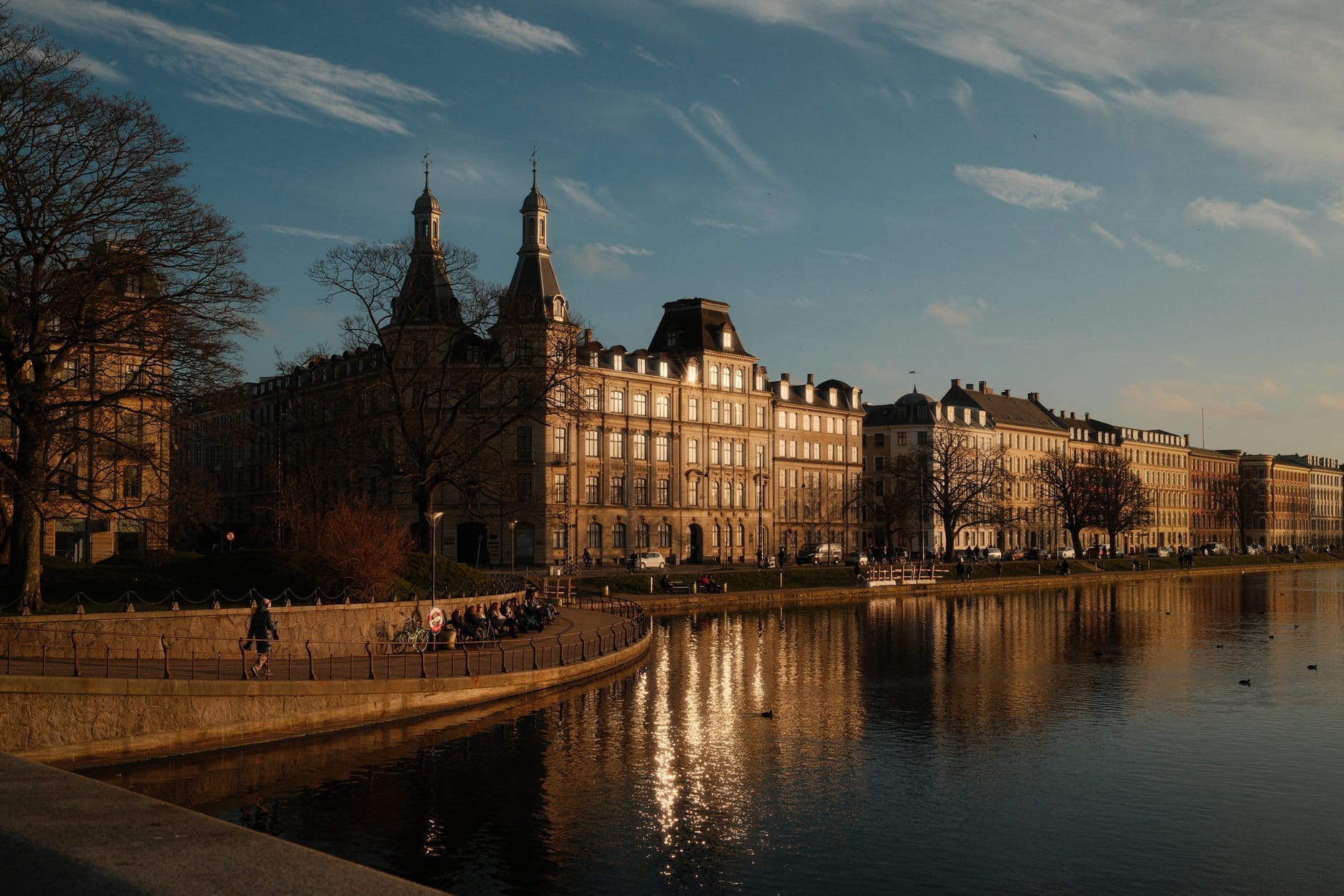
What Are The Lakes?
Søerne — The Lakes — are three connected artificial lakes that trace the old western boundary of Copenhagen's historic city centre. The three bodies of water, Sankt Jørgens Sø, Peblinge Sø, and Sortedams Sø, are divided into five basins and together stretch just over 3.2 km from north to south. They average around 200 metres in width, making them wide enough to feel genuinely open, yet narrow enough that you always have the opposite bank in view.
This is not a manicured park with entrance gates and admission charges. There are no fences, no ticket booths, and no posted hours because there are none to post. The paths along the lakeshores are public right-of-way, used continuously by locals going to work, runners doing laps before breakfast, and retirees walking dogs in the late afternoon. That ordinariness is precisely what makes Søerne worth understanding before you visit.
ℹ️ Good to know
The Lakes are a public outdoor space with no admission fee and no closing time. Access is free 24 hours a day, year-round.
A History Written in Water
The origins of The Lakes reach back to the 16th and 17th centuries, when the City of Copenhagen dammed several small streams along its western edge to create a defensive moat system. Water was a practical military asset: wide, open stretches of it slowed any approaching army and gave defenders time to respond. Later, as the threat of siege receded, the lakes were repurposed as Copenhagen's primary drinking water reservoir, a role they held well into the modern period.
That functional history explains the shape of the lakes today. They are long, narrow, and arranged in a near-straight line, following the old city boundary rather than any natural topography. The bridges that cross them at regular intervals, and the broad pedestrian paths running alongside, were laid out when the city expanded westward in the late 19th century and the lakes shifted from infrastructure to urban amenity. Walking the circuit today, you are following a route shaped by centuries of civic pragmatism rather than landscape design.
Tickets & tours
Hand-picked options from our booking partner. Prices are indicative; availability and final rates are confirmed when you complete your booking.
1-hour boat harbour tour in Copenhagen
From 26 €Instant confirmationFree cancellationSmall group 3-hour walking tour in Copenhagen
From 45 €Instant confirmationFree cancellationCopenhagen to Malmo one-day tour
From 56 €Instant confirmationFree cancellationFull-day tour to Forest Tower and Forgotten Giants from Copenhagen
From 110 €Instant confirmationFree cancellation
What the Walk Actually Looks Like
The full circuit around all three lakes covers roughly 6.3 to 6.6 km of predominantly flat path. The surface is paved for most of the route, with some gravel sections, making it accessible for pushchairs and cyclists as well as pedestrians. There are no significant hills. The paths run directly alongside the water, with benches placed at intervals, and the views across each lake are unobstructed for long stretches.
Each lake has a slightly different feel. Sankt Jørgens Sø, the southernmost basin near the Tycho Brahe Planetarium, tends to attract a denser mix of cyclists and commuters because of its proximity to the Forum Metro station. Peblinge Sø in the middle section is where you will find more benches and more people simply sitting. Sortedams Sø, at the northern end approaching Østerbrogade, is often the quietest of the three, with a slightly wider shoreline margin and more visible birdlife.
If you are planning a longer walk through the city, The Lakes connect naturally to several surrounding districts. The eastern shore runs directly alongside Indre By, while the western shore touches Nørrebro, Vesterbro, and Østerbro at various points, making Søerne a natural dividing line and crossing point between central Copenhagen and its bridge neighborhoods.
How the Experience Changes by Time of Day
Early morning is when The Lakes are closest to empty. Between 6 and 8 am on a weekday, you will share the path mainly with runners doing laps, a few dog walkers, and the occasional cyclist. The water at this hour is often very still, and in cooler months a low mist can sit on the surface, catching the early light in a way that is genuinely striking without requiring any photographic effort.
By mid-morning on a sunny day, particularly in spring and summer, the benches fill up and the paths get considerably more crowded. Lunchtime on a weekday brings office workers out from the surrounding streets. Weekend afternoons are the busiest periods overall: picnic blankets appear on the grass margins, inline skaters use the smoother sections of path, and kayakers occasionally appear on the wider parts of the water. The atmosphere is social rather than meditative at these times.
Evenings around sunset are worth planning for specifically. The long Danish summer evenings (daylight can extend past 9 pm in June) mean the light over the western shore can be exceptional around 8 to 9 pm. The crowds thin out from their afternoon peak, and the city noise drops slightly. This is the window most photographers target.
💡 Local tip
For photography, aim for the hour after sunrise or the 90 minutes before sunset. The low angle of light across the water surface minimises glare and brings out reflections of the city skyline on the opposite bank.
Wildlife and Ecology
Despite being an artificial urban water body, Søerne supports a notable population of waterbirds. Mute swans are the most conspicuous residents and are present year-round, frequently close enough to observe in detail from the shore. Mallards, coots, and great crested grebes are common. In winter, the lakes attract diving ducks that are rarely seen in summer, including tufted duck and occasionally greater scaup.
The lakes are not designated swimming areas. The water quality is managed for ecological purposes rather than bathing, and there are no formal facilities for entering the water for swimming. Kayaking and small non-motorised craft are permitted in sections, and in summer it is possible to rent pedal boats, but this should be verified with current local rules before attempting it.
Getting There and Getting Around
The most straightforward public transport access is Forum Metro Station on the M1/M2 lines, which places you at the southern end of the lakes near Sankt Jørgens Sø and the Tycho Brahe Planetarium. From here, you can join the lakeside path immediately and walk north along the full length if you choose. Multiple bus routes also run along the roads bordering the lakes, particularly along the eastern shore.
Copenhagen is one of the world's most cycle-friendly cities, and reaching The Lakes by bike is often the most practical option. Rental bikes are available across the city centre. For a broader look at navigating Copenhagen by two wheels, the cycling in Copenhagen guide covers routes, rental options, and rules in detail.
The Copenhagen Card covers unlimited public transport, which makes reaching the lakes from any part of the city straightforward, though the card's main value comes from its museum access rather than transit alone.
💡 Local tip
If you are walking from Nyhavn or the inner city, The Lakes are only about a 15-minute walk west from Kongens Nytorv. No transit required.
Seasonal Variations and What to Expect in Each
Spring (April to May) is arguably the most rewarding season. The trees along the paths come into leaf, migratory birds return, and the light quality improves dramatically after the grey winter months. Temperatures are cool but walkable, and crowds are lighter than in summer.
Summer (June to August) brings maximum activity. The paths are busy from morning to evening, and the grass margins become informal gathering spaces on weekends. If you want a quieter experience in summer, the early morning window before 8 am is your best option.
Autumn (September to October) is underrated. The leaf colour along the eastern bank can be striking, the summer crowds are gone, and the lake surface becomes glassy on calm days. Dress for temperatures that can drop quickly after sunset.
Winter (November to March) is cold and often damp. The lakes rarely freeze fully, but they can develop ice in severe cold spells. The walk is still accessible and can be atmospheric in clear winter light, but expect temperatures around 0 to 4°C and dress accordingly. For broader context on what Copenhagen offers in the colder months, the Copenhagen Christmas guide covers the seasonal atmosphere across the city.
Who Should Skip This Attraction
If your priority is indoor cultural experiences, ticketed attractions, or structured sightseeing, The Lakes will not compete with Copenhagen's museums and historic sites for your time. This is an outdoor urban walk, not an attraction with a defined programme. Visitors with limited mobility should note that while the paths are generally flat, some sections have uneven paving, and there are no formal accessible facilities along the route.
On a rainy day in winter, the experience is significantly less rewarding than in better weather. The paths offer no shelter, and the surrounding streetscape, while pleasant, does not compensate for the absence of the views across open water that define the appeal.
Insider Tips
- The northwestern corner of Sortedams Sø, near Dronning Louises Bro (Queen Louise's Bridge), is where locals tend to gather on sunny afternoons. The bridge is a social landmark in its own right and worth pausing on, even if just for the view south along the length of the lakes.
- If you are running laps, the full 6.3–6.6 km circuit is well-marked in the minds of local runners, but unmarked on the ground. Turn right from Forum Metro and simply follow the water; the circuit is obvious and continuous.
- The eastern path, running along the Indre By side, tends to be slightly busier with commuter cyclists. If you want a more relaxed walk, the western shore paths through Nørrebro and Vesterbro are generally quieter on weekday mornings.
- Bring a wide-angle lens or use your phone's panoramic mode on the wider sections of Peblinge Sø. The flat perspective and reflective surface make for striking photos that do not require any particular photographic skill to capture.
- The Tycho Brahe Planetarium at the southern end of Sankt Jørgens Sø doubles as a useful orientation landmark. Its distinctive cylindrical shape is visible from the path and helps you track where you are on the circuit without a map.
Who Is The Lakes (Søerne) For?
- Runners and walkers wanting a flat, scenic, car-free route through a real neighbourhood
- Travellers who want to observe everyday Copenhagen life rather than tourist circuits
- Photographers targeting early-morning reflections or long summer evening light
- Birdwatchers interested in urban waterbirds, particularly in winter when diving ducks are present
- Budget-conscious visitors looking for a genuinely rewarding free outdoor experience
Nearby Attractions
Other things to see while in Indre By (Old Town):
- Amalienborg Palace
Amalienborg is the official home of the Danish royal family and one of Copenhagen's most architecturally coherent ensembles. Four near-identical Rococo palaces frame a grand octagonal square, with the Amalienborg Museum open to visitors inside Christian VIII's Palace. The daily changing of the guard at noon is a punctual, unhurried ceremony worth timing your visit around.
- The Black Diamond
The Black Diamond is the modern extension of the Royal Danish Library, clad in polished black granite and angled toward the harbour on Slotsholmen. Entry is free, the atrium is genuinely impressive, and the building rewards visitors who take time to understand what they are looking at.
- Botanical Garden of the University of Copenhagen
Tucked behind Nørreport Station in the heart of the city, the Copenhagen University Botanical Garden is a 10-hectare green sanctuary with a Victorian glasshouse complex, a tranquil lake, and around 8,000 plant species. Entry to the grounds is free, making it one of the most rewarding stops in central Copenhagen for any pace of traveler.
- Christiansborg Palace
Christiansborg Palace sits on the Slotsholmen islet in central Copenhagen, serving simultaneously as the home of the Danish Parliament, the Supreme Court, the Prime Minister's Office, and the Royal Reception Rooms. It is widely described as uniquely housing all three branches of Denmark’s national government under one roof, and its 106-metre tower offers one of the best free panoramic views in the city.